


Aviation Accident Final Report - National Transportation Safety Board
The National Transportation Safety Board did not travel to the scene of this accident.
Additional Participating Entity:
Federal Aviation Administration / Flight Standards District Office; Lubbock, Texas
Investigation Docket - National Transportation Safety Board:
Location: Lamesa, Texas
Accident Number: CEN22LA108
Date and Time: January 14, 2022, 19:02 Local
Registration: N6916D
Aircraft: Piper PA-22-150
Aircraft Damage: Substantial
Defining Event: Controlled flight into terr/obj (CFIT)
Injuries: 1 None
Flight Conducted Under: Part 91: General aviation - Personal
Analysis
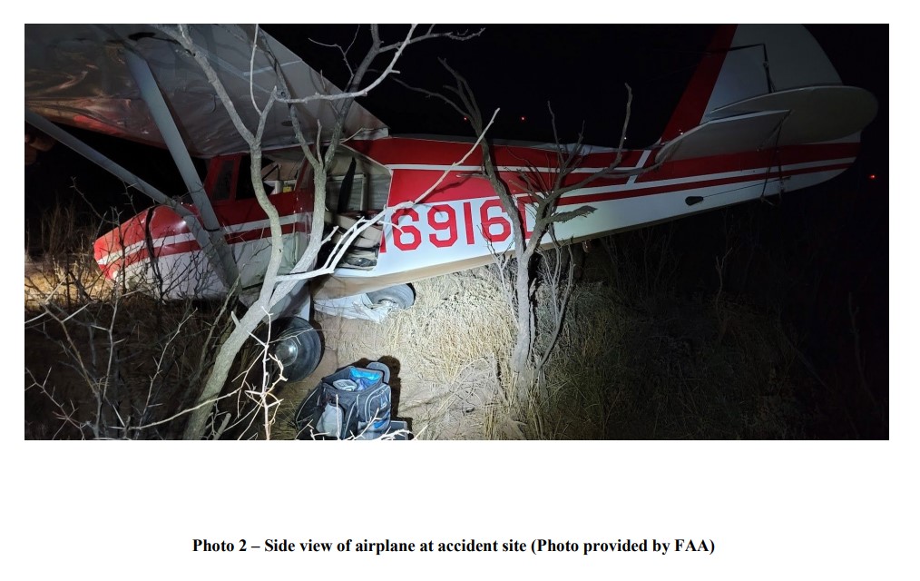
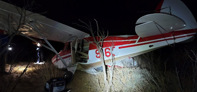
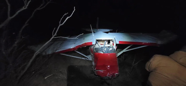
During the night visual flight rules cross-country flight, the pilot monitored weather conditions on his tablet computer and observed “unspecified meteorological conditions,” which encompassed his intended destination. The pilot elected to divert to an alternate destination and climbed to 4,500 ft msl. The pilot noted that he had a kneeboard with destination airport information, and after diverting, he made notes denoting changes to reflect the new destination. He did not recall if he changed the pattern altitude for the new destination. He attributed this omission to distraction during the flight while he modified his flight plan via the airplane radio. As he approached the new destination, the horizon was not “definite,” but he could see the lights of the city and began a shallow descent. While descending, he noted that the city lights disappeared, and as he contemplated why this happened, the airplane struck the ground. He reported that there were no mechanical problems with the airplane before the accident and he “just flew it into the ground.”
The field elevation at the original destination was 1,561 ft msl, and the elevation new destination was 2,999 ft msl.
Probable Cause and Findings
The National Transportation Safety Board determines the probable cause(s) of this accident to be:
The pilot’s failure to maintain clearance from terrain during a descent that resulted in an impact with terrain.
Findings
Aircraft Altitude - Not attained/maintained
Personnel issues Flight planning/navigation - Pilot
Factual Information
History of Flight
Enroute-descent Controlled flight into terr/obj (CFIT) (Defining event)
Pilot Information
Certificate: Private
Age: 70, Male
Airplane Rating(s): Single-engine land
Seat Occupied: Left
Other Aircraft Rating(s): None
Restraint Used: 4-point
Instrument Rating(s): None
Second Pilot Present: No
Instructor Rating(s): None
Toxicology Performed:
Medical Certification: BasicMed Unknown
Last FAA Medical Exam:
Occupational Pilot: No
Last Flight Review or Equivalent:
Flight Time: 1200 hours (Total, all aircraft), 800 hours (Total, this make and model)
Aircraft and Owner/Operator Information
Aircraft Make: Piper
Registration: N6916D
Model/Series: PA-22-150
Aircraft Category: Airplane
Year of Manufacture: 1957
Amateur Built:
Airworthiness Certificate: Normal
Serial Number: 22-4833
Landing Gear Type: Tricycle
Seats: 4
Date/Type of Last Inspection: Unknown
Certified Max Gross Wt.: 2000 lbs
Time Since Last Inspection:
Engines: 1 Reciprocating
Airframe Total Time:
Engine Manufacturer: Lycoming
ELT: Installed, not activated Engine Model/Series: O-320
Registered Owner:
Rated Power: 150
Operator: On file
Operating Certificate(s) Held: None
Meteorological Information and Flight Plan
Conditions at Accident Site: Visual (VMC)
Condition of Light: Night/dark
Observation Facility, Elevation: KGNC,3315 ft msl
Distance from Accident Site: 36 Nautical Miles
Observation Time:
Direction from Accident Site: 264°
Lowest Cloud Condition: Scattered / 1800 ft AGL
Visibility: 5 miles
Lowest Ceiling: Broken / 2400 ft AGL
Visibility (RVR):
Wind Speed/Gusts: 19 knots / 27 knots
Turbulence Type Forecast/Actual: /
Wind Direction: 20°
Turbulence Severity Forecast/Actual: /
Altimeter Setting: 29.97 inches Hg
Temperature/Dew Point: 17°C / -4°C
Precipitation and Obscuration: Moderate - None - Haze
Departure Point: Addison, TX (ADS)
Type of Flight Plan Filed: VFR
Destination: Lamesa, TX
Type of Clearance: None
Departure Time: 16:08 Local
Type of Airspace: Class G
Wreckage and Impact Information
Crew Injuries: 1 None
Aircraft Damage: Substantial
Passenger Injuries: N/A
Aircraft Fire: None
Ground Injuries:
Aircraft Explosion: None
Total Injuries: 1 None
Latitude, Longitude: 32.7376,-101.951(est)


No comments:
Post a Comment