Sunday, January 02, 2022

Loss of Control on Ground: Cessna R182 Skylane RG, N757ZZ; accident occurred May 30, 2021 at Minden-Tahoe Airport (KMEV), Douglas County, Nevada


Aviation Accident Final Report - National Transportation Safety Board
 

The National Transportation Safety Board did not travel to the scene of this accident. 

Additional Participating Entity: 
Federal Aviation Administration / Flight Standards District Office; Reno, Nevada

Investigation Docket - National Transportation Safety Board:
https://data.ntsb.gov/Docket

SkyKing Aviation Services LLC


Location: Minden, Nevada
Accident Number: WPR21LA215
Date and Time: May 30, 2021, 13:15 Local
Registration: N757ZZ
Aircraft: Cessna R182 
Aircraft Damage: Substantial
Defining Event: Loss of control on ground 
Injuries: 1 Minor, 2 None
Flight Conducted Under: Part 91: General aviation - Instructional

Analysis

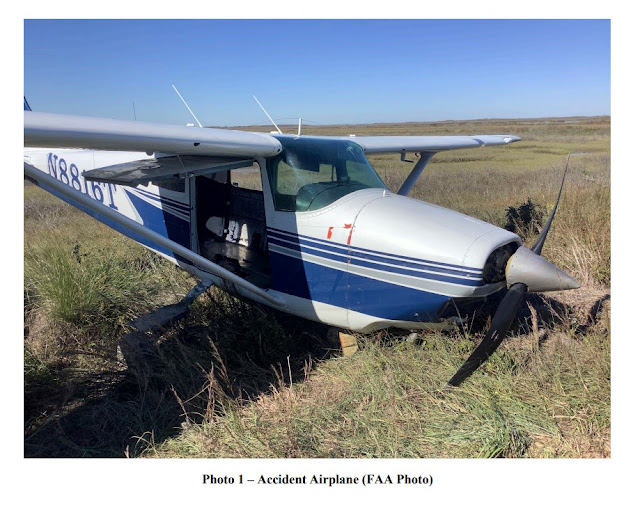
The pilot receiving instruction reported that, during the first landing roll of the instructional flight, the airplane deviated slightly to the right and away from the runway centerline. The pilot receiving instruction corrected to the left and described the subsequent movement of the airplane as crabbing to the left while tracking down the runway. The flight instructor asserted that the pilot receiving instruction overcorrected with excessive left rudder and brake. The flight instructor told the pilot receiving instruction to get off the brake, and she applied right rudder. The instructor stated that the pilot receiving instruction “froze up” and she could not regain directional control of the airplane. The airplane exited the left side of the runway, nosed over and came to rest inverted. The airplane sustained substantial damage to the right-wing lift strut and the empennage.

The flight instructor and the pilot receiving instruction both reported that there were no preaccident mechanical failures or malfunctions with the airplane that would have precluded normal operation. At the time of the accident, the pilot receiving instruction was landing the airplane on runway 34 with variable wind at 5 knots, gusting to 11 knots.

Probable Cause and Findings

The National Transportation Safety Board determines the probable cause(s) of this accident to be:
The pilot receiving instruction’s failure to maintain directional control during the landing roll, and the flight instructor’s delayed remedial action. 

Findings

Personnel issues Aircraft control - Student/instructed pilot
Aircraft Directional control - Not attained/maintained
Personnel issues Delayed action - Instructor/check pilot
Personnel issues Monitoring other person - Instructor/check pilot

Factual Information

History of Flight

Landing-landing roll Loss of control on ground (Defining event)

Flight instructor Information

Certificate: Commercial; Flight instructor; Private
Age: 26, Male
Airplane Rating(s): Single-engine land
Seat Occupied: Right
Other Aircraft Rating(s): Unmanned (sUAS)
Restraint Used: 3-point
Instrument Rating(s): Airplane
Second Pilot Present: Yes
Instructor Rating(s): Airplane single-engine
Toxicology Performed:
Medical Certification: Class 1 None
Last FAA Medical Exam: August 1, 2021
Occupational Pilot: Yes
Last Flight Review or Equivalent: February 18, 2021
Flight Time: (Estimated) 584 hours (Total, all aircraft), 69 hours (Total, this make and model), 85 hours (Last 90 days, all aircraft)

Pilot Information

Certificate: Airline transport; Commercial
Age: 60, Male
Airplane Rating(s): Single-engine land; Multi-engine land
Seat Occupied: Left
Other Aircraft Rating(s): None
Restraint Used: 3-point
Instrument Rating(s): 
Airplane Second Pilot Present: Yes
Instructor Rating(s): None 
Toxicology Performed:
Medical Certification: Class 1 With waivers/limitations 
Last FAA Medical Exam: June 15, 2020
Occupational Pilot: Yes
Last Flight Review or Equivalent: September 3, 2020
Flight Time: (Estimated) 15000 hours (Total, all aircraft), 0 hours (Total, this make and model), 10000 hours (Pilot In Command, all aircraft)

Aircraft and Owner/Operator Information

Aircraft Make: Cessna
Registration: N757ZZ
Model/Series: R182 RG 
Aircraft Category: Airplane
Year of Manufacture: 1979 
Amateur Built:
Airworthiness Certificate: Normal
Serial Number: R18201278
Landing Gear Type: Retractable - Tricycle
Seats: 4
Date/Type of Last Inspection: April 30, 2021 Annual
Certified Max Gross Wt.: 1195 lbs
Time Since Last Inspection: 5039.3 Hrs
Engines: 1 Reciprocating
Airframe Total Time: 5095.2 Hrs at time of accident
Engine Manufacturer: LYCOMING
ELT: C126 installed, not activated
Engine Model/Series: 0-540
Registered Owner:
Rated Power: 250 Horsepower
Operator:
Operating Certificate(s) Held: None

Meteorological Information and Flight Plan

Conditions at Accident Site: Visual (VMC)
Condition of Light: Day
Observation Facility, Elevation: KMEV, 4726 ft msl
Distance from Accident Site: 0 Nautical Miles
Observation Time: 13:35 Local
Direction from Accident Site: 170°
Lowest Cloud Condition: 
Visibility: 10 miles
Lowest Ceiling:
Visibility (RVR):
Wind Speed/Gusts: / 11 knots 
Turbulence Type Forecast/Actual:  /
Wind Direction:
Turbulence Severity Forecast/Actual:  /
Altimeter Setting: 30.08 inches Hg
Temperature/Dew Point: 28°C / -7°C
Precipitation and Obscuration: No Obscuration; No Precipitation
Departure Point: Minden, NV
Type of Flight Plan Filed: None
Destination: Minden, NV 
Type of Clearance: VFR
Departure Time:
Type of Airspace: Class G

Airport Information

Airport: MINDEN-TAHOE MEV
Runway Surface Type: Asphalt
Airport Elevation: 4723 ft msl
Runway Surface Condition: Dry
Runway Used: 16/34
IFR Approach: None
Runway Length/Width: 7399 ft / 100 ft 
VFR Approach/Landing: Stop and go

Wreckage and Impact Information

Crew Injuries: 1 Minor, 1 None
Aircraft Damage: Substantial
Passenger Injuries: 1 None 
Aircraft Fire: None
Ground Injuries:
Aircraft Explosion: None
Total Injuries: 1 Minor, 2 None 
Latitude, Longitude: 39.0005,-119.75111 (est)

Loss of Control on Ground: Cessna 182P Skylane, N47UP; accident occurred May 31, 2021 at McClellan-Palomar Airport (KCRQ), Carlsbad, San Diego County, California


Aviation Accident Final Report - National Transportation Safety Board 

The National Transportation Safety Board did not travel to the scene of this accident. 

Additional Participating Entity: 
Federal Aviation Administration / Flight Standards District Office; San Diego, California

Investigation Docket - National Transportation Safety Board:

Superfast Skylane LLC
Location: Carlsbad, California
Accident Number: WPR21LA217
Date and Time: May 31, 2021, 08:34 Local 
Registration: N47UP
Aircraft: Cessna 182 
Aircraft Damage: Substantial
Defining Event: Loss of control on ground 
Injuries: 1 None
Flight Conducted Under: Part 91: General aviation - Instructional

Analysis

The solo student pilot reported that, during the approach for landing, she was slightly low and added power before touchdown. When the airplane touched down, it bounced, and she increased engine power. The airplane subsequently veered to the left. She then applied right rudder control, but the airplane exited the runway to the left and impacted runway signs. The engine mounts were substantially damaged. The student pilot reported that there were no preaccident mechanical malfunctions or failures with the airplane that would have precluded normal operation.

Probable Cause and Findings

The National Transportation Safety Board determines the probable cause(s) of this accident to be:
The student pilot’s improper landing flare, which resulted in a bounced landing and subsequent loss of directional control.

Findings

Personnel issues Decision making/judgment - Student/instructed pilot
Personnel issues Aircraft control - Student/instructed pilot
Aircraft Landing flare - Not attained/maintained
Environmental issues Sign/marker - Effect on operation

Factual Information

History of Flight

Landing-flare/touchdown Loss of control on ground (Defining event)

Pilot Information

Certificate: Student
Age: 49, Female
Airplane Rating(s): None 
Seat Occupied: Left
Other Aircraft Rating(s): None
Restraint Used:
Instrument Rating(s): None
Second Pilot Present: No
Instructor Rating(s): None 
Toxicology Performed:
Medical Certification: Class 3 With waivers/limitations 
Last FAA Medical Exam: April 1, 2021
Occupational Pilot: No
Last Flight Review or Equivalent:
Flight Time: (Estimated) 32 hours (Total, all aircraft), 7.3 hours (Total, this make and model), 0.3 hours (Pilot In Command, all aircraft), 32 hours (Last 90 days, all aircraft), 14.1 hours (Last 30 days, all aircraft), 0.9 hours (Last 24 hours, all aircraft)

Aircraft and Owner/Operator Information

Aircraft Make: Cessna
Registration: N47UP
Model/Series: 182 P
Aircraft Category: Airplane
Year of Manufacture: 1976
Amateur Built:
Airworthiness Certificate: Normal 
Serial Number: 182649594
Landing Gear Type: Tricycle 
Seats: 4
Date/Type of Last Inspection: April 15, 2021 100 hour 
Certified Max Gross Wt.: 2950 lbs
Time Since Last Inspection: 14.4 Hrs
Engines: 1 Reciprocating
Airframe Total Time: 1362.3 Hrs at time of accident
Engine Manufacturer: Continental
ELT: C91 installed, not activated
Engine Model/Series: D-470-S
Registered Owner:
Rated Power: 230 Horsepower
Operator: 
Operating Certificate(s) Held: None

Meteorological Information and Flight Plan

Conditions at Accident Site: Visual (VMC)
Condition of Light: Day
Observation Facility, Elevation: KCRQ, 328 ft msl
Distance from Accident Site: 0 Nautical Miles
Observation Time: 07:53 Local 
Direction from Accident Site: 105°
Lowest Cloud Condition: 
Visibility: 6 miles
Lowest Ceiling: 
Visibility (RVR):
Wind Speed/Gusts: / 
Turbulence Type Forecast/Actual: None / None
Wind Direction: 
Turbulence Severity Forecast/Actual: N/A / N/A
Altimeter Setting: 29.97 inches Hg 
Temperature/Dew Point: 15°C / 12°C
Precipitation and Obscuration: Moderate - None - Haze
Departure Point: Carlsbad, CA 
Type of Flight Plan Filed: VFR
Destination: Carlsbad, CA
Type of Clearance: None
Departure Time: 
Type of Airspace: Class D

Airport Information

Airport: MC CLELLAN-PALOMAR CRQ
Runway Surface Type: Asphalt
Airport Elevation: 330 ft msl
Runway Surface Condition: Dry
Runway Used: 24 
IFR Approach: None
Runway Length/Width: 4897 ft / 150 ft
VFR Approach/Landing: Touch and go; Traffic pattern

Wreckage and Impact Information

Crew Injuries: 1 None 
Aircraft Damage: Substantial
Passenger Injuries:
Aircraft Fire: On-ground
Ground Injuries: 
Aircraft Explosion: None
Total Injuries: 1 None 
Latitude, Longitude: 33.12825,-117.28008(est)

Hard Landing: LET L-23 Super Blanik, N912B; accident occurred May 31, 2021 at Brokenstraw Airport (P15), Pittsfield, Warren County, Pennsylvania


Aviation Accident Final Report - National Transportation Safety Board

The National Transportation Safety Board traveled to the scene of this accident.

Additional Participating Entity: 
Federal Aviation Administration / Flight Standards District Office; Pittsburgh, Pennsylvania

Investigation Docket - National Transportation Safety Board: 
Location: Pittsfield, Pennsylvania
Accident Number: ERA21LA242
Date and Time: May 31, 2021, 14:00 Local 
Registration: N912B
Aircraft: LET L-23 SUPER BLANIK 
Aircraft Damage: Substantial
Defining Event: Hard landing
Injuries: 1 None
Flight Conducted Under: Part 91: General aviation - Instructional

Analysis

The student pilot had completed a training flight to pattern altitude just prior to the accident flight with his flight instructor. After that flight, the glider was towed to 3,000 feet above ground level and released from the tow rope so the student pilot could get some solo practice. The total duration of the solo flight was approximately 1.5 hours. Nothing unusual occurred with the flight until the student pilot turned on to the final leg of the traffic pattern for landing. The glider descended quicker than usual as the student pilot had the airbrakes (wing spoilers) extended. The pilot also stated that developed a leg cramp in his right leg on final approach. The pilot subsequently landed the glider “hard” and after touchdown, the pilot lost directional control. The glider then veered off the left side of the runway, struck a runway light and a drainage culvert with the right wing leading edge and lower airbrake, and then struck a taxiway light with the left wing. The glider’s right wing and fuselage were substantially damaged.

Probable Cause and Findings

The National Transportation Safety Board determines the probable cause(s) of this accident to be:
The student pilot’s improper landing flare, which resulted in a hard landing and loss of directional control.

Findings

Personnel issues Aircraft control - Student/instructed pilot
Aircraft Landing flare - Not attained/maintained

Factual Information

History of Flight

Landing-flare/touchdown Hard landing (Defining event)
Landing Loss of control on ground

Pilot Information

Certificate: Student 
Age: 67, Male
Airplane Rating(s): None 
Seat Occupied: Front
Other Aircraft Rating(s): None 
Restraint Used: 4-point
Instrument Rating(s): None
Second Pilot Present: No
Instructor Rating(s): None
Toxicology Performed:
Medical Certification: None, None 
Last FAA Medical Exam:
Occupational Pilot: No
Last Flight Review or Equivalent:
Flight Time: 21 hours (Total, all aircraft), 21 hours (Total, this make and model), 3 hours (Pilot In Command, all aircraft), 3 hours (Last 90 days, all aircraft), 3 hours (Last 30 days, all aircraft), 2 hours (Last 24 hours, all aircraft)

Aircraft and Owner/Operator Information

Aircraft Make: LET 
Registration: N912B
Model/Series: L-23 SUPER BLANIK
Aircraft Category: Glider
Year of Manufacture: 1992
Amateur Built:
Airworthiness Certificate: Utility
Serial Number: 917912
Landing Gear Type: Retractable - Tandem 
Seats: 2
Date/Type of Last Inspection: May 10, 2021 Annual 
Certified Max Gross Wt.: 1124 lbs
Time Since Last Inspection: 
Engines: 0
Airframe Total Time: 1274.3 Hrs as of last inspection
Engine Manufacturer:
ELT: Not installed
Engine Model/Series:
Registered Owner: 
Rated Power:
Operator: 
Operating Certificate(s) Held: None

Meteorological Information and Flight Plan

Conditions at Accident Site: Visual (VMC)
Condition of Light: Day
Observation Facility, Elevation: KJHW,1723 ft msl 
Distance from Accident Site: 20 Nautical Miles
Observation Time: 13:56 Local
Direction from Accident Site: 15°
Lowest Cloud Condition: Clear 
Visibility: 10 miles
Lowest Ceiling: None
Visibility (RVR):
Wind Speed/Gusts: 10 knots / 
Turbulence Type
Forecast/Actual:  /
Wind Direction: 270°
Turbulence Severity Forecast/Actual:  /
Altimeter Setting: 30.3 inches Hg 
Temperature/Dew Point: 17°C / 3°C
Precipitation and Obscuration: No Obscuration; No Precipitation
Departure Point: Pittsfield, PA (P15)
Type of Flight Plan Filed: None
Destination: Pittsfield, PA
Type of Clearance: None
Departure Time: 12:30 Local
Type of Airspace: Class G

Airport Information

Airport: BROKENSTRAW P15
Runway Surface Type: Grass/turf
Airport Elevation: 1230 ft msl 
Runway Surface Condition: Dry
Runway Used: 27 
IFR Approach: None
Runway Length/Width: 3650 ft / 100 ft 
VFR Approach/Landing: Full stop; Traffic pattern

Wreckage and Impact Information

Crew Injuries: 1 None 
Aircraft Damage: Substantial
Passenger Injuries:
Aircraft Fire: None
Ground Injuries: 
Aircraft Explosion: None
Total Injuries: 1 None
Latitude, Longitude: 41.83294,-79.360671 (est)

Loss of Control on Ground: Van's RV-6, N16CX; accident occurred May 18, 2021 at Byron Airport (C83), Contra Costa County, California


Aviation Accident Final Report - National Transportation Safety Board 

The National Transportation Safety Board did not travel to the scene of this accident. 

Additional Participating Entity:
Federal Aviation Administration / Flight Standards District Office; Oakland, California

Investigation Docket - National Transportation Safety Board:
Location: Byron, California
Accident Number: WPR21LA199
Date and Time: May 18, 2021, 14:00 Local
Registration: N16CX
Aircraft: Harry Crosby (Vans) RV-6 
Aircraft Damage: Substantial
Defining Event: Loss of control on ground
Injuries: 1 Minor
Flight Conducted Under: Part 91: General aviation - Personal

Analysis

The pilot in the tailwheel-equipped airplane reported that, during the takeoff roll, the wind was variable and gusting from the left. He initiated the takeoff roll and applied left aileron and right rudder pedal pressure. The tailwheel lifted from the ground about 40 knots ground speed and the airplane veered to the left. Subsequently the pilot applied full right rudder and simultaneously applied full left aileron, but the airplane exited the left side of the runway. The pilot continued the takeoff roll as he believed that the airplane would start to climb. However, the airplane collided with a drainage culvert located about 25 ft from the left side of the runway. The airplane sustained substantial damage to the right-wing spar and ribs. The pilot reported that there were no preaccident mechanical failures or malfunctions with the airplane that would have precluded normal operations.

The METAR located at the accident airport reported that about the time of the accident, the wind direction was from 230° with a velocity of 20 knots and gusting to 25 knots. The pilot was departing from runway 23.

Probable Cause and Findings

The National Transportation Safety Board determines the probable cause(s) of this accident to be:
The pilot’s failure to maintain directional control of the airplane during takeoff while operating in gusting wind conditions, which resulted in a runway excursion and subsequent collision with terrain. 

Findings

Aircraft Directional control - Not attained/maintained
Personnel issues Aircraft control - Pilot
Environmental issues Gusts - Effect on operation

Factual Information

History of Flight

Takeoff Loss of control on ground (Defining event)

Pilot Information

Certificate: Private 
Age: 88, Male
Airplane Rating(s): Single-engine land
Seat Occupied: Left
Other Aircraft Rating(s): None 
Restraint Used: 5-point
Instrument Rating(s): None
Second Pilot Present: No
Instructor Rating(s): None 
Toxicology Performed:
Medical Certification: Sport pilot With waivers/limitations
Last FAA Medical Exam: October 27, 2020
Occupational Pilot: No
Last Flight Review or Equivalent: November 21, 2020
Flight Time: (Estimated) 2074 hours (Total, all aircraft), 1814 hours (Total, this make and model), 2031 hours (Pilot In Command, all aircraft), 28 hours (Last 90 days, all aircraft), 13 hours (Last 30 days, all aircraft), 1 hours (Last 24 hours, all aircraft)

Aircraft and Owner/Operator Information

Aircraft Make: Harry Crosby (Vans)
Registration: N16CX
Model/Series: RV-6
Aircraft Category: Airplane
Year of Manufacture: 2004
Amateur Built: Yes
Airworthiness Certificate: Experimental (Special) 
Serial Number: 23159
Landing Gear Type: Tailwheel
Seats: 2
Date/Type of Last Inspection: June 11, 2020 Condition
Certified Max Gross Wt.: 1800 lbs
Time Since Last Inspection: 25 Hrs
Engines: 1 Reciprocating
Airframe Total Time: 1809.5 Hrs at time of accident
Engine Manufacturer: Lycoming
ELT: C91 installed, not activated
Engine Model/Series: O-360-A1A
Registered Owner: 
Rated Power: 180 Horsepower
Operator: 
Operating Certificate(s) Held: None

Meteorological Information and Flight Plan

Conditions at Accident Site: Visual (VMC) 
Condition of Light: Day
Observation Facility, Elevation: KC83,393 ft msl
Distance from Accident Site: 12 Nautical Miles
Observation Time: 14:53 Local 
Direction from Accident Site: 228°
Lowest Cloud Condition: Clear 
Visibility: 9 miles
Lowest Ceiling: 
Visibility (RVR):
Wind Speed/Gusts: 20 knots / 25 knots 
Turbulence Type Forecast/Actual:  /
Wind Direction: 230° 
Turbulence Severity Forecast/Actual:  /
Altimeter Setting: 29.99 inches Hg 
Temperature/Dew Point: 28°C / 4°C
Precipitation and Obscuration: No Obscuration; No Precipitation
Departure Point: Byron, CA
Type of Flight Plan Filed: None
Destination: Livermore, CA (LVK)
Type of Clearance: VFR
Departure Time: 
Type of Airspace: Class G

Airport Information

Airport: BYRON C83
Runway Surface Type: Asphalt
Airport Elevation: 78 ft msl 
Runway Surface Condition: Dry
Runway Used: 23 
IFR Approach: None
Runway Length/Width: 3000 ft / 75 ft
VFR Approach/Landing: None

Wreckage and Impact Information

Crew Injuries: 1 Minor
Aircraft Damage: Substantial
Passenger Injuries:
Aircraft Fire: None
Ground Injuries: 
Aircraft Explosion: None
Total Injuries: 1 Minor 
Latitude, Longitude: 37.828444,-121.62583 (est)

Loss of Control on Ground: Maule M-4, N4718T; accident occurred June 02, 2021 at Mahoney Creek USFS Airport (0U3), Cascade, Valley County, Idaho


Aviation Accident Final Report - National Transportation Safety Board 

The National Transportation Safety Board did not travel to the scene of this accident. 

Additional Participating Entity: 
Federal Aviation Administration / Flight Standards District Office; Boise, Idaho 

Investigation Docket - National Transportation Safety Board:
Location: Cascade, Idaho
Accident Number: WPR21LA229
Date and Time: June 2, 2021, 10:05 Local
Registration: N4718T
Aircraft: Maule M-4
Aircraft Damage: Substantial
Defining Event: Loss of control on ground
Injuries: 1 None
Flight Conducted  Under: Part 91: General aviation - Personal

Analysis

The pilot of the tailwheel-equipped airplane reported that, after landing, and during taxi to the end of the runway to turn around to park, he did not see a deep steep ditch at the end of the runway. The airplane traveled into the ditch as the pilot applied full right rudder and full right brake in an attempt to turn, however, the airplane continued to slide into the ditch where the left-wing impact terrain.

The airplane sustained substantial damage to the left wing.

The pilot reported that there were no preaccident mechanical failures or malfunctions with the airplane that would have precluded normal operation.

Probable Cause and Findings

The National Transportation Safety Board determines the probable cause(s) of this accident to be:
The pilot’s failure to maintain clearance from a ditch, which resulted in impact with terrain.

Findings

Personnel issues Monitoring environment - Pilot
Environmental issues Sloped/uneven terrain - Effect on equipment

Factual Information

History of Flight

Taxi-from runway Loss of control on ground (Defining event)

Pilot Information

Certificate: Private
Age: 73, Male
Airplane Rating(s): Single-engine land 
Seat Occupied: Unknown
Other Aircraft Rating(s): None 
Restraint Used: Unknown
Instrument Rating(s): None
Second Pilot Present:
Instructor Rating(s): None
Toxicology Performed:
Medical Certification: Class 3 With waivers/limitations 
Last FAA Medical Exam: September 4, 2020
Occupational Pilot: No 
Last Flight Review or Equivalent: May 17, 2021
Flight Time: (Estimated) 1045 hours (Total, all aircraft), 615 hours (Total, this make and model), 977 hours (Pilot In Command, all aircraft), 24.4 hours (Last 90 days, all aircraft), 24.4 hours (Last 30 days, all aircraft), 3.7 hours (Last 24 hours, all aircraft)

Aircraft and Owner/Operator Information

Aircraft Make: Maule
Registration: N4718T
Model/Series: M-4 
Aircraft Category: Airplane
Year of Manufacture: 1964
Amateur Built:
Airworthiness Certificate: Normal
Serial Number: 61
Landing Gear Type: Tailwheel
Seats: 4
Date/Type of Last Inspection: October 1, 2020 Annual
Certified Max Gross Wt.: 2100 lbs
Time Since Last Inspection: 31 Hrs
Engines: 1 Reciprocating
Airframe Total Time: 2750.9 Hrs at time of accident
Engine Manufacturer: Continental
ELT: C126 installed, not activated 
Engine Model/Series: O-300-A
Registered Owner: 
Rated Power: 145 Horsepower
Operator: 
Operating Certificate(s) Held: None

Meteorological Information and Flight Plan

Conditions at Accident Site: Visual (VMC) 
Condition of Light: Day
Observation Facility, Elevation: KLLJ, 5072 ft msl
Distance from Accident Site: 33 Nautical Miles
Observation Time: 09:55 Local
Direction from Accident Site: 114°
Lowest Cloud Condition: Clear
Visibility: 10 miles
Lowest Ceiling: 
Visibility (RVR):
Wind Speed/Gusts: 3 knots / 
Turbulence Type Forecast/Actual: None / None
Wind Direction: 60° 
Turbulence Severity Forecast/Actual: N/A / N/A
Altimeter Setting: 30.12 inches Hg
Temperature/Dew Point: 21°C / 6°C
Precipitation and Obscuration: No Obscuration; No Precipitation
Departure Point: Soldier Bar, ID (85U)
Type of Flight Plan Filed: None
Destination: Cascade, ID
Type of Clearance: Unknown
Departure Time: 
Type of Airspace: Class G

Airport Information

Airport: MAHONEY CREEK USFS 0U3
Runway Surface Type: Dirt
Airport Elevation: 4618 ft msl
Runway Surface Condition: Dry
Runway Used: 04
IFR Approach: None
Runway Length/Width: 2150 ft / 15 ft 
VFR Approach/Landing: None

Wreckage and Impact Information

Crew Injuries: 1 None 
Aircraft Damage: Substantial
Passenger Injuries:
Aircraft Fire: None
Ground Injuries: 
Aircraft Explosion: None
Total Injuries: 1 None 
Latitude, Longitude: 44.744583,-114.92138

Loss of Tail Rotor Effectiveness: (Hughes) TH55A/269A, N41G; accident occurred June 03, 2021 at Monroe Regional Airport (KMLU), Ouachita Parish, Louisiana


Aviation Accident Final Report - National Transportation Safety Board 

The National Transportation Safety Board did not travel to the scene of this accident.

Additional Participating Entity: 
Federal Aviation Administration / Flight Standards District Office; Baton Rouge, Louisiana

Investigation Docket - National Transportation Safety Board:
Location: Monroe, Louisiana
Accident Number: CEN21LA253
Date and Time: June 3, 2021, 12:15 Local
Registration: N41G
Aircraft: SCHWEIZER(HUGHES) AIRCRAFT CORP TH55A/269A 
Aircraft Damage: Substantial
Defining Event: Loss of tail rotor effectiveness 
Injuries: 2 None
Flight Conducted Under: Part 91: General aviation - Personal

Analysis

The pilot reported that on short final to land, the helicopter lost tail rotor authority and the helicopter began an uncommanded right yaw. He attempted to recover and landed on a grass area which resulted in a hard landing. The fuselage and skids sustained substantial damage. The pilot noted on his report of the accident that there were no mechanical failures or malfunctions of the helicopter that would have precluded normal operations.

Probable Cause and Findings

The National Transportation Safety Board determines the probable cause(s) of this accident to be:
The pilot’s failure to maintain yaw control during landing which resulted in a loss of tail rotor effectiveness.

Findings

Personnel issues Aircraft control - Pilot
Aircraft Yaw control - Not attained/maintained

Factual Information

History of Flight

Approach-VFR pattern final Loss of tail rotor effectiveness (Defining event)
Landing Hard landing

Pilot Information

Certificate: Commercial; Private 
Age: 34, Male
Airplane Rating(s): Single-engine land
Seat Occupied: Right
Other Aircraft Rating(s): Helicopter
Restraint Used: 4-point
Instrument Rating(s): Airplane; Helicopter 
Second Pilot Present: No
Instructor Rating(s): None
Toxicology Performed:
Medical Certification: Class 1 Without waivers/limitations
Last FAA Medical Exam: January 4, 2021
Occupational Pilot: Yes 
Last Flight Review or Equivalent:
Flight Time: 2620 hours (Total, all aircraft), 12 hours (Total, this make and model), 2210 hours (Pilot In Command, all aircraft), 55 hours (Last 90 days, all aircraft), 21 hours (Last 30 days, all aircraft), 1 hours (Last 24 hours, all aircraft)

Aircraft and Owner/Operator Information

Aircraft Make: SCHWEIZER(HUGHES)AIRCRAFT CORP
Registration: N41G
Model/Series: TH55A/269A 
Aircraft Category: Helicopter
Year of Manufacture: 1969
Amateur Built:
Airworthiness Certificate: Normal 
Serial Number: 291097(67-16990)
Landing Gear Type: Skid 
Seats: 2
Date/Type of Last Inspection: July 12, 2020 Annual
Certified Max Gross Wt.: 1670 lbs
Time Since Last Inspection: 77 Hrs 
Engines: 1 Reciprocating
Airframe Total Time: 10324 Hrs as of last inspection
Engine Manufacturer: Lycoming
ELT: Installed, not activated 
Engine Model/Series: HIO-360-B1A
Registered Owner: 
Rated Power: 180 Horsepower
Operator:
Operating Certificate(s) Held: None

Meteorological Information and Flight Plan

Conditions at Accident Site: Visual (VMC) 
Condition of Light: Day
Observation Facility, Elevation: KMLU,79 ft msl
Distance from Accident Site: 0 Nautical Miles
Observation Time: 12:23 Local 
Direction from Accident Site: 0°
Lowest Cloud Condition: Clear
Visibility: 10 miles
Lowest Ceiling: None 
Visibility (RVR):
Wind Speed/Gusts: / 
Turbulence Type Forecast/Actual:  /
Wind Direction:
Turbulence Severity Forecast/Actual:  /
Altimeter Setting: 30.02 inches Hg
Temperature/Dew Point: 27°C / 18°C
Precipitation and Obscuration: No Obscuration; No Precipitation
Departure Point: Monroe, LA 
Type of Flight Plan Filed: None
Destination: Monroe, LA
Type of Clearance: VFR
Departure Time: 
Type of Airspace: Class D

Airport Information

Airport: MONROE RGNL MLU
Runway Surface Type:
Airport Elevation: 79 ft msl 
Runway Surface Condition: Dry
Runway Used: 
IFR Approach: None
Runway Length/Width:
VFR Approach/Landing: Traffic pattern

Wreckage and Impact Information

Crew Injuries: 1 None
Aircraft Damage: Substantial
Passenger Injuries: 1 None
Aircraft Fire: None
Ground Injuries: 
Aircraft Explosion: None
Total Injuries: 2 None
Latitude, Longitude: 32.510861,-92.037667

Fuel Starvation: Van's RV-9A, N20YY; accident occurred June 04, 2021 in West Portsmouth, Scioto County, Ohio


Aviation Accident Final Report - National Transportation Safety Board

The National Transportation Safety Board did not travel to the scene of this accident. 

Additional Participating Entity: 
Federal Aviation Administration / Flight Standards District Office; Cincinnati, Ohio 

Investigation Docket - National Transportation Safety Board: 

Location: West Portsmouth, Ohio
Accident Number: CEN21LA250
Date and Time: June 4, 2021, 18:45 Local 
Registration: N20YY
Aircraft: Vans RV9 
Aircraft Damage: Substantial
Defining Event: Fuel starvation 
Injuries: 1 Minor, 1 None
Flight Conducted Under: Part 91: General aviation - Personal

Analysis

The pilot reported he’d taken off and was about 10 minutes from the airport when the airplane’s engine lost power and began to descend. The pilot misdiagnosed the power loss as an electronic ignition problem and troubleshot it as such. However, after turning on the electric fuel pump and switching fuel tanks several times, the pilot was unable to restore engine power and elected to perform a forced landing to a field. During the forced landing the airplane nosed over and came to rest inverted. The airplane sustained substantial damage to the rudder. Federal Aviation Administration inspectors reported that during a postaccident examination of the airplane the right fuel tank was empty, and the left fuel tank had about 4 gallons of fuel. The fuel selector had the right fuel tank selected. No other mechanical failures or malfunctions with the airplane were found that would have precluded normal operations. The pilot reported he spoke with the previous owner and was unaware that when switching fuel tanks, it could take about 10 seconds for the new tank to pick up fuel. The pilot reported that he had never run a fuel tank empty and was not familiar with how the engine would respond, and how long it would take for fuel to return to the engine when another fuel tank was selected.

Probable Cause and Findings

The National Transportation Safety Board determines the probable cause(s) of this accident to be:
The pilot’s improper use of the airplane’s fuel system, which resulted in a total loss of engine power due to fuel starvation.

Findings

Personnel issues Knowledge of equipment - Pilot
Aircraft Fuel - Fluid management
Environmental issues (general) - Contributed to outcome

Factual Information

History of Flight

Initial climb Fuel starvation (Defining event)
Initial climb Loss of engine power (total)
Landing-flare/touchdown Off-field or emergency landing

Pilot Information

Certificate: Private 
Age: 43, Male
Airplane Rating(s): Single-engine land 
Seat Occupied: Left
Other Aircraft Rating(s): None
Restraint Used: 3-point
Instrument Rating(s): None
Second Pilot Present:
Instructor Rating(s): None 
Toxicology Performed:
Medical Certification: Class 3 With waivers/limitations 
Last FAA Medical Exam: November 22, 2016
Occupational Pilot: No
Last Flight Review or Equivalent: September 14, 2020
Flight Time: 276.5 hours (Total, all aircraft), 225 hours (Total, this make and model), 276.5 hours (Pilot In Command, all aircraft), 24.6 hours (Last 90 days, all aircraft), 8 hours (Last 30 days, all aircraft), 3 hours (Last 24 hours, all aircraft)

Aircraft and Owner/Operator Information

Aircraft Make: Vans 
Registration: N20YY
Model/Series: RV9 A
Aircraft Category: Airplane
Year of Manufacture: 2006
Amateur Built: Yes
Airworthiness Certificate: Experimental (Special) 
Serial Number: 90778
Landing Gear Type: Tricycle
Seats: 2
Date/Type of Last Inspection: May 11, 2021 Condition
Certified Max Gross Wt.:
Time Since Last Inspection: 15 Hrs
Engines: 1 Reciprocating
Airframe Total Time: 971 Hrs as of last inspection
Engine Manufacturer: Continental Titan
ELT: Installed, not activated 
Engine Model/Series: X-361-A1A
Registered Owner: 
Rated Power: 185 Horsepower
Operator: On file
Operating Certificate(s) Held: None

Meteorological Information and Flight Plan

Conditions at Accident Site: Visual (VMC) 
Condition of Light: Day
Observation Facility, Elevation: KDWU, 546 ft msl
Distance from Accident Site: 19 Nautical Miles
Observation Time: 18:56 Local
Direction from Accident Site: 138°
Lowest Cloud Condition: Clear 
Visibility: 10 miles
Lowest Ceiling: None
Visibility (RVR):
Wind Speed/Gusts: 4 knots / 
Turbulence Type Forecast/Actual:  /
Wind Direction: 280°
Turbulence Severity Forecast/Actual:  /
Altimeter Setting: 30 inches Hg
Temperature/Dew Point: 28°C / 17°C
Precipitation and Obscuration: No Obscuration; No Precipitation
Departure Point: Portsmouth, OH (KPMH) 
Type of Flight Plan Filed: VFR
Destination: Flemingsburg, KY (KFGX)
Type of Clearance: VFR
Departure Time: 18:45 Local
Type of Airspace: Class G

Wreckage and Impact Information

Crew Injuries: 1 None
Aircraft Damage: Substantial
Passenger Injuries: 1 Minor
Aircraft Fire: None
Ground Injuries: 
Aircraft Explosion: None
Total Injuries: 1 Minor, 1 None
Latitude, Longitude: 38.791468,-83.014358 (est)

Cessna 182C Skylane, N8816T: Accident occurred January 01, 2022 near Mustang Beach Airport (KRAS), Port Aransas, Nueces County, Texas


This is preliminary information, subject to change, and may contain errors. Any errors in this report will be corrected when the final report has been completed. 

The National Transportation Safety Board did not travel to the scene of this accident. 

Additional Participating Entity:
Federal Aviation Administration / Flight Standards District Office; San Antonio, Texas

Investigation Docket - National Transportation Safety Board:

SafeSix Aviation LLC

Skydive jump pilot


Location: Port Aransas, Texas
Accident Number: CEN22LA094
Date and Time: January 1, 2022, 12:20 Local
Registration: N8816T
Aircraft: Cessna 182C 
Injuries: 1 None
Flight Conducted Under: Part 91: General aviation - Skydiving

Aircraft and Owner/Operator Information

Aircraft Make: Cessna 
Registration: N8816T
Model/Series: 182C 
Aircraft Category: Airplane
Amateur Built:
Operator: 
Operating Certificate(s) Held: None
Operator Designator Code:

Meteorological Information and Flight Plan

Conditions at Accident Site: VMC
Condition of Light:
Observation Facility, Elevation: KTFP, 17 ft msl
Observation Time: 12:15 Local
Distance from Accident Site: 9 Nautical Miles
Temperature/Dew Point: 30°C /22°C
Lowest Cloud Condition: Clear 
Wind Speed/Gusts, Direction: 8 knots / , 220°
Lowest Ceiling: None 
Visibility: 10 miles
Altimeter Setting: 29.69 inches Hg 
Type of Flight Plan Filed:
Departure Point:
Destination:

Wreckage and Impact Information

Crew Injuries: 1 None 
Aircraft Damage: Substantial
Passenger Injuries: 
Aircraft Fire: None
Ground Injuries: N/A
Aircraft Explosion: None
Total Injuries: 1 None
Latitude, Longitude: 27.808258,-97.08233 (est)


PORT ARANSAS, Texas — Multiple agencies responded to a plane crash in Port Aransas Saturday evening. Luckily there were no injuries.

Texas Department of Public Safety tells us that around 5:15 Saturday afternoon a plane crashed into the water, just west of the runway at Port Aransas Airport.

The pilot and one other person were onboard and escaped with no injuries, according to DPS. They are suspecting the crash is due to a mechanical failure, but can’t be certain until their investigation is complete.

Assisting on the scene were Port Aransas police and fire departments, Texas General Land Office and the Coast Guard. The airport will reopen Sunday. DPS plans to file their official report Sunday morning.