Tuesday, December 28, 2021

Runway Incursion - Vehicle: Stinson 108-3 Voyager, N6548M; accident occurred June 27, 2021 near Key Way Airport (19WA), Stevenson, Skamania County, Washington


Aviation Accident Final Report - National Transportation Safety Board

The National Transportation Safety Board did not travel to the scene of this accident. 

Additional Participating Entity: 
Federal Aviation Administration / Flight Standards District Office; Portland, Oregon

Investigation Docket - National Transportation Safety Board:


Location: Stevenson, Washington 
Accident Number: WPR21LA251
Date and Time: June 27, 2021, 08:28 Local 
Registration: N6548M
Aircraft: Stinson 108-3
Aircraft Damage: Destroyed
Defining Event: Runway incursion veh/AC/person 
Injuries: 2 Serious
Flight Conducted Under: Part 91: General aviation - Personal

Analysis

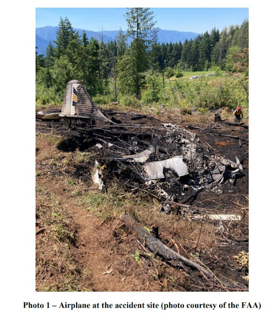
The pilot reported that, he planned to fly one circuit in the traffic pattern, and then land from the south. The landing approach was uneventful, and having reached midfield, he began to initiate the flare. A van then crossed the runway directly in front of the airplane, and the pilot decided to perform a go-around. Although the airplane began to slowly climb, it was not climbing at a rate sufficient to clear the approaching rising terrain, and within a few seconds they reached the end of the runway. The pilot attempted to perform a forced landing into a clearing about 1,000 ft beyond the end of the runway, and shortly after impacting the ground,
the airplane caught fire and was destroyed.

The pilot reported that there were no preaccident mechanical failures or malfunctions with the airplane or engine that would have precluded normal operation. He stated that standard procedures called for retracting the flaps once a positive rate of climb had been established, however he did not do so because the climb performance was not sufficient.

The airport owner reported that, due to rising terrain to the north of the 2,300 ft-long private turf airstrip, landing approaches from the south were recommended. The airstrip was 100 ft wide and bound by trees immediately to the left and right.

Probable Cause and Findings

The National Transportation Safety Board determines the probable cause(s) of this accident to be:
A runway incursion, which resulted in a go-around, and subsequent forced landing when the airplane was not able to climb at a rate sufficient to clear approaching rising terrain. 

Findings
Environmental issues Ground vehicle - Effect on operation
Environmental issues Mountainous/hilly terrain - Contributed to outcome

Factual Information

History of Flight

Landing-flare/touchdown Runway incursion veh/AC/person (Defining event)
Approach-VFR go-around Collision during takeoff/land

Pilot Information

Certificate: Private 
Age: 52, Male
Airplane Rating(s): Single-engine land 
Seat Occupied: Rear
Other Aircraft Rating(s): None
Restraint Used: 4-point
Instrument Rating(s): None 
Second Pilot Present:
Instructor Rating(s): None 
Toxicology Performed:
Medical Certification: BasicMed Without waivers/limitations
Last FAA Medical Exam: May 27, 2021
Occupational Pilot: No 
Last Flight Review or Equivalent:
Flight Time: (Estimated) 988 hours (Total, all aircraft), 214 hours (Total, this make and model)

Aircraft and Owner/Operator Information

Aircraft Make: Stinson 
Registration: N6548M
Model/Series: 108-3
Aircraft Category: Airplane
Year of Manufacture: 1948 
Amateur Built:
Airworthiness Certificate: Normal 
Serial Number: 108-4548
Landing Gear Type: Tailwheel
Seats: 4
Date/Type of Last Inspection: October 18, 2020 Annual 
Certified Max Gross Wt.: 2400 lbs
Time Since Last Inspection: 30 Hrs
Engines: 1 Reciprocating
Airframe Total Time: 3100 Hrs as of last inspection
Engine Manufacturer: Franklin
ELT: C91A installed, not activated 
Engine Model/Series: 6A-4165-B3
Registered Owner: 
Rated Power: 105 Horsepower
Operator: On file
Operating Certificate(s) Held: None

Meteorological Information and Flight Plan

Conditions at Accident Site: Visual (VMC)
Condition of Light: Day
Observation Facility, Elevation: KTTD,29 ft msl 
Distance from Accident Site: 24 Nautical Miles
Observation Time: 08:53 Local
Direction from Accident Site: 245°
Lowest Cloud Condition: Clear
Visibility: 10 miles
Lowest Ceiling: None
Visibility (RVR):
Wind Speed/Gusts: / 
Turbulence Type Forecast/Actual:  /
Wind Direction:
Turbulence Severity Forecast/Actual:  /
Altimeter Setting: 29.83 inches Hg
Temperature/Dew Point: 29°C / 15°C
Precipitation and Obscuration: No Obscuration; No Precipitation
Departure Point: Stevenson, WA (19WA)
Type of Flight Plan Filed: None
Destination: Stevenson, WA 
Type of Clearance: None
Departure Time: 08:15 Local 
Type of Airspace: Class G

Airport Information

Airport: KEY WAY 19WA 
Runway Surface Type: Grass/turf
Airport Elevation: 972 ft msl 
Runway Surface Condition: Dry
Runway Used: 15/33
IFR Approach: None
Runway Length/Width: 2300 ft / 100 ft 
VFR Approach/Landing: Go around

Wreckage and Impact Information

Crew Injuries: 1 Serious 
Aircraft Damage: Destroyed
Passenger Injuries: 1 Serious 
Aircraft Fire: On-ground
Ground Injuries: 
Aircraft Explosion: None
Total Injuries: 2 Serious
Latitude, Longitude: 45.724543,-121.88893


Loss of Control in Flight: Best Off Skyranger B, N7714E; accident occurred June 27, 2021 in Ellicott, El Paso County, Colorado


Aviation Accident Final Report - National Transportation Safety Board 

The National Transportation Safety Board did not travel to the scene of this accident.

Additional Participating Entity:
Federal Aviation Administration / Flight Standards District Office; Denver, Colorado

Investigation Docket - National Transportation Safety Board:


Location: Ellicott, Colorado
Accident Number: CEN21LA292
Date and Time: June 27, 2021, 10:20 Local
Registration: N7714E
Aircraft: CURNUTT ELTON E SKY RANGER B 
Aircraft Damage: Substantial
Defining Event: Loss of control in flight
Injuries: 2 Minor
Flight Conducted Under: Part 91: General aviation - Personal

Analysis

The pilot reported the flight’s purpose was to fly “low and slow” over the riverbed for a ceremony. During a left turn initiated about 250 ft above ground level, the pilot noticed a sink rate develop. The pilot applied full power, but the sink rate continued, and the airplane struck a tree that resulted in substantial damage to both wings and the fuselage. The pilot reported that there were no preaccident mechanical malfunctions or failures with the airplane that would have precluded normal operation.

Probable Cause and Findings

The National Transportation Safety Board determines the probable cause(s) of this accident to be:
The pilot’s loss of control while maneuvering at low altitude.

Findings

Personnel issues Aircraft control - Pilot
Aircraft Airspeed - Not attained/maintained

Factual Information

History of Flight

Maneuvering-low-alt flying Loss of control in flight (Defining event)
Uncontrolled descent Collision with terr/obj (non-CFIT)

Pilot Information

Certificate: Private 
Age: 65, Male
Airplane Rating(s): Single-engine land
Seat Occupied: Right
Other Aircraft Rating(s): None
Restraint Used: 4-point
Instrument Rating(s): None 
Second Pilot Present: No
Instructor Rating(s): None 
Toxicology Performed:
Medical Certification: None 
Last FAA Medical Exam:
Occupational Pilot: No 
Last Flight Review or Equivalent: July 16, 2020
Flight Time: 662 hours (Total, all aircraft), 662 hours (Total, this make and model), 11 hours (Last 90 days, all aircraft), 8 hours (Last 30 days, all aircraft), 0 hours (Last 24 hours, all aircraft)

Aircraft and Owner/Operator Information

Aircraft Make: CURNUTT ELTON E 
Registration: N7714E
Model/Series: SKY RANGER B 
Aircraft Category: Airplane
Year of Manufacture: 2005 
Amateur Built:
Airworthiness Certificate: Experimental light sport (Special)
Serial Number: SKR 0503 573
Landing Gear Type: Tricycle
Seats: 2
Date/Type of Last Inspection: June 28, 2020 Condition 
Certified Max Gross Wt.: 1320 lbs
Time Since Last Inspection: 19 Hrs 
Engines: 1 Reciprocating
Airframe Total Time: 682 Hrs at time of accident 
Engine Manufacturer: Rotax
ELT: C126 installed, activated, aided in locating accident
Engine Model/Series: 912ULS
Registered Owner: 
Rated Power: 100 Horsepower
Operator: 
Operating Certificate(s) Held: None

Meteorological Information and Flight Plan

Conditions at Accident Site: Visual (VMC)
Condition of Light: Day
Observation Facility, Elevation: KABH,6030 ft msl 
Distance from Accident Site: 8 Nautical Miles
Observation Time: 09:58 Local
Direction from Accident Site: 146°
Lowest Cloud Condition: Scattered / 7000 ft AGL 
Visibility: 10 miles
Lowest Ceiling: Overcast / 10000 ft AGL 
Visibility (RVR):
Wind Speed/Gusts: 5 knots / 
Turbulence Type Forecast/Actual: None / None
Wind Direction: 340° 
Turbulence Severity Forecast/Actual: N/A / N/A
Altimeter Setting: 30.28 inches Hg 
Temperature/Dew Point: 16°C / 8°C
Precipitation and Obscuration: No Obscuration; No Precipitation
Departure Point: Peyton, CO (KFLY)
Type of Flight Plan Filed: None
Destination: Peyton, CO (KFLY) 
Type of Clearance: None
Departure Time: 10:00 Local 
Type of Airspace: Class G

Wreckage and Impact Information

Crew Injuries: 1 Minor 
Aircraft Damage: Substantial
Passenger Injuries: 1 Minor
Aircraft Fire: None
Ground Injuries:
Aircraft Explosion: None
Total Injuries: 2 Minor 
Latitude, Longitude: 38.914,-104.443 (est)

Loss of Control in Flight: Cessna A185F Skywagon 185, N8216J; accident occurred June 27, 2021 at Nushagak Airport (AK21), Dillingham, Alaska


Aviation Accident Final Report - National Transportation Safety Board 

The National Transportation Safety Board did not travel to the scene of this accident. 

Additional Participating Entity: 
Federal Aviation Administration / Flight Standards District Office; Anchorage, Alaska

Investigation Docket - National Transportation Safety Board:
Location: Dillingham, Alaska
Accident Number: ANC21LA050
Date & Time: June 27, 2021, 17:00 Local
Registration: N8216J
Aircraft: Cessna A185F 
Aircraft Damage: Substantial
Defining Event: Loss of control in flight 
Injuries: 3 None
Flight Conducted Under: Part 91: General aviation - Business

Analysis

The pilot reported that, just after takeoff from the narrow brush lined airstrip, he encountered a wind gust which pushed the airplane to the left. The left wing struck the brush and the airplane spun around and impacted terrain sustaining substantial damage to the fuselage. The pilot reported that there were no preaccident mechanical malfunctions or anomalies that would have precluded normal operation.

Probable Cause and Findings

The National Transportation Safety Board determines the probable cause(s) of this accident to be:
The pilot’s failure to maintain directional control during takeoff in gusting wind conditions which resulted in a loss of control and impact with terrain.

Findings

Aircraft Directional control - Not attained/maintained
Personnel issues Aircraft control - Pilot
Environmental issues Gusts - Effect on operation

Factual Information

History of Flight

Takeoff Loss of control in flight (Defining event)

Pilot Information

Certificate: Private
Age: 59, Male
Airplane Rating(s): Single-engine land; Single-engine sea
Seat Occupied: Left
Other Aircraft Rating(s): None 
Restraint Used: 3-point
Instrument Rating(s): None 
Second Pilot Present:
Instructor Rating(s): None 
Toxicology Performed:
Medical Certification: Class 3 With waivers/limitations 
Last FAA Medical Exam: June 8, 2021
Occupational Pilot: No
Last Flight Review or Equivalent: September 7, 2019
Flight Time: 1907 hours (Total, all aircraft), 1267 hours (Total, this make and model), 1826 hours (Pilot In Command, all aircraft), 56 hours (Last 90 days, all aircraft), 39 hours (Last 30 days, all aircraft), 2 hours (Last 24 hours, all aircraft)

Aircraft and Owner/Operator Information

Aircraft Make: Cessna
Registration: N8216J
Model/Series: A185F 
Aircraft Category: Airplane
Year of Manufacture: 1976 
Amateur Built:
Airworthiness Certificate: Normal 
Serial Number: 18502864
Landing Gear Type: Tailwheel
Seats:
Date/Type of Last Inspection: May 15, 2021 Annual 
Certified Max Gross Wt.: 3350 lbs
Time Since Last Inspection: 
Engines: 1 Reciprocating
Airframe Total Time: 
Engine Manufacturer: CONT MOTOR
ELT: C126 installed, activated
Engine Model/Series: IO 520 D
Registered Owner: 
Rated Power: 300 Horsepower
Operator: On file 
Operating Certificate(s) Held: None

Meteorological Information and Flight Plan

Conditions at Accident Site: Visual (VMC) 
Condition of Light: Day
Observation Facility, Elevation: PAJZ, 270 ft msl 
Distance from Accident Site: 17 Nautical Miles
Observation Time: 16:56 Local
Direction from Accident Site: 121°
Lowest Cloud Condition: 
Visibility: 6 miles
Lowest Ceiling: Overcast / 3700 ft AGL 
Visibility (RVR):
Wind Speed/Gusts: 3 knots / 
Turbulence Type Forecast/Actual:  /
Wind Direction: 170° 
Turbulence Severity Forecast/Actual:  /
Altimeter Setting: 30.23 inches Hg
Temperature/Dew Point: 14°C / 8°C
Precipitation and Obscuration: Moderate - None - Haze
Departure Point: Dillingham, AK 
Type of Flight Plan Filed: None
Destination: Portage Creek , AK
Type of Clearance: None
Departure Time: 
Type of Airspace: Class G

Airport Information

Airport: NUSHAGAK AK21 
Runway Surface Type: Grass/turf
Airport Elevation: 40 ft msl 
Runway Surface Condition: Rough
Runway Used: 16/34
IFR Approach: None
Runway Length/Width: 1000 ft / 50 ft
VFR Approach/Landing: None

Wreckage and Impact Information

Crew Injuries: 1 None
Aircraft Damage: Substantial
Passenger Injuries: 2 None 
Aircraft Fire: None
Ground Injuries:
Aircraft Explosion: None
Total Injuries: 3 None 
Latitude, Longitude: 59.88313,-157.76075

Aerodynamic Stall / Spin: Piper PA-32-260 Cherokee Six, N55455; fatal accident occurred January 25, 2020 near Cannon Creek Airpark (15FL), Lake City, Columbia County, Florida

Salena Short
~


Salena Gail Short
1959 - 2020
~


Aviation Accident Final Report - National Transportation Safety Board

The National Transportation Safety Board traveled to the scene of this accident.

Additional Participating Entities:
Federal Aviation Administration / Flight Standards District Office; Orlando, Florida
Lycoming; Williamsburg, Pennsylvania
Piper; Vero Beach, Florida

Investigation Docket - National Transportation Safety Board:


Location: Lake City, Florida
Accident Number: ERA20FA085
Date and Time: January 25, 2020, 09:30 Local
Registration: N55455
Aircraft: Piper PA32
Aircraft Damage: Destroyed
Defining Event: Aerodynamic stall/spin 
Injuries: 1 Fatal
Flight Conducted Under: Part 91: General aviation - Personal

Analysis

A witness described that, when the pilot arrived at the airport several days before the accident, the airplane’s engine “cut out” while on final approach to the runway. After landing uneventfully, the pilot had a mechanic service the airplane, and the engine performed normally. On the day of the accident, as the airplane departed, the witness reported that he watched the airplane turn “hard left” after it cleared trees near the runway. He later heard a loud bang, then saw smoke. He drove over to the smoke and saw that the airplane was completely engulfed in flames. The airplane came to rest in the yard of a residence about 1,000 feet left of the runway’s midpoint.

Postaccident examination of the airplane was limited due to impact and postcrash fire damage; however, no defects consistent with a preimpact failure or malfunction of either the airframe or engine were observed. Additionally, a sound spectrum analysis of the audio from a video recording showed that the engine was likely running slightly below full throttle before the accident. Given this information, there was no evidence that a loss of engine power preceded the accident.

The witness’s description that the airplane was in a “hard left” turn, the location of the accident site relatively close to the runway, the lack of a discernable horizontal wreckage path, and little fragmentation of the wreckage to suggest a high-energy impact, were consistent with the airplane impacting the ground in a near-vertical descent at a relatively low speed. Thus, it is likely that the pilot exceeded the airplane’s critical angle of attack during the steep, low-altitude turn shortly after takeoff, which resulted in an aerodynamic stall and loss of airplane control at an altitude too low for recovery.

Probable Cause and Findings

The National Transportation Safety Board determines the probable cause(s) of this accident to be:
The pilot's exceedance of the airplane's critical angle of attack, which resulted in an aerodynamic stall and subsequent loss of control at low altitude.

Findings

Personnel issues Aircraft control - Pilot
Aircraft Angle of attack - Not attained/maintained

Factual Information

HISTORY OF FLIGHT

On January 25, 2020, about 0930 eastern standard time, a Piper PA32-260, N55455, was destroyed when was involved in an accident near Lake City, Florida. The private pilot was fatally injured. The airplane was operated as a Title 14 Code of Federal Regulations Part 91 personal flight.

A witness stated that the pilot flew to Cannon Creek Airpark (15FL), Lake City, Florida, the weekend before the accident. At that time, the pilot said the engine “cut out” on short final approach to the runway; however, after landing, the pilot performed an engine run-up, and the engine performed normally. The pilot and the witness subsequently opened the engine cowling and observed an oil leak. The pilot contacted a local mechanic to fix the oil leak. A couple of days later, the pilot ran the engine, and no oil leaks were noted. The night before the accident flight, the pilot and the witness taxied the airplane to the fuel tank and topped off the wing tanks and left-wing tip tank, but they did not put fuel in the right-wing tip tank because it had a fuel leak.

On the morning of the accident, the witness and pilot performed a preflight inspection of the airplane and noted no anomalies. The witness watched the airplane take off from runway 36 and noticed that the pilot “turned hard left” after the airplane cleared the trees, which was earlier than normal. The witness returned to his vehicle when he heard a loud bang and saw smoke. He drove over to the smoke and saw that the airplane was engulfed in flames.

WRECKAGE AND IMPACT INFORMATION

The airplane came to rest on the side of a house in a subdivision about 1,000 ft to the west side of the midpoint of the runway. The wreckage was oriented on a heading of 215° and there was no discernable horizontal wreckage path. A postaccident fire consumed the airplane, and only the tail section remained intact and undamaged by fire. The cockpit, instrument panel, firewall, fuselage, and wings were all destroyed by the fire, and the engine accessory case was consumed by fire; the magnetos, fuel pump, carburetor, vacuum pump, and oil filter were destroyed. All major components of the airplane were accounted for at the scene. Control cable continuity was confirmed to the respective controls.

Postaccident examination of the engine revealed the engine crankcase and cylinders were intact. The top spark plugs were removed, and a borescope examination of the cylinder walls, exhaust, intake valves and piston heads revealed no anomalies. The engine’s crankshaft was rotated by hand and thumb compression was established on all cylinders. Valve train continuity was established throughout the engine by observing movement of the rocker arms and rear accessory case gears.

Both propeller blades remained attached to the hub. One blade was bent aft about midblade, and both blades were twisted near the tip. 

A witness near the airport captured the airplane engine noise on a video camera. The airplane was not captured by the video, and its position, ground track, speed, and therefore at what point during the accident sequence the captured audio occurred could not be determined. A sound spectrum analysis of the audio by the National Transportation Safety Board Vehicle Recorders Laboratory revealed that during the time audio from the accident airplane’s engine was recorded, the engine rpm was approximately 2,584 rpm, which was slightly below the maximum rated 2,700 rpm.

MEDICAL AND PATHOLOGICAL INFORMATION

An autopsy performed on the pilot by the Office of the Office of the Medical Examiner, Jacksonville, Florida, reported the cause of death as blunt force trauma.

Toxicology testing performed at the FAA Forensic Sciences Laboratory found no tested-for drugs or alcohol.

History of Flight

Initial climb Aerodynamic stall/spin (Defining event)
Uncontrolled descent Collision with terr/obj (non-CFIT)

Pilot Information

Certificate: Private
Age: 61,Female
Airplane Rating(s): Single-engine land 
Seat Occupied: Left
Other Aircraft Rating(s): None 
Restraint Used: Unknown
Instrument Rating(s): None
Second Pilot Present: No
Instructor Rating(s): None 
Toxicology Performed: Yes
Medical Certification: Class 3 With waivers/limitations 
Last FAA Medical Exam: July 15, 2016
Occupational Pilot: No 
Last Flight Review or Equivalent:
Flight Time: 172.5 hours (Total, all aircraft), 172.5 hours (Total, this make and model)

Aircraft and Owner/Operator Information

Aircraft Make: Piper
Registration: N55455
Model/Series: PA32 260 
Aircraft Category: Airplane
Year of Manufacture: 1973
Amateur Built:
Airworthiness Certificate: Normal 
Serial Number: 32-7300038
Landing Gear Type: Tricycle
Seats: 6
Date/Type of Last Inspection: August 1, 2019 Annual 
Certified Max Gross Wt.: 3400 lbs
Time Since Last Inspection:
Engines: 1 Reciprocating
Airframe Total Time: 3554.3 Hrs as of last inspection
Engine Manufacturer: Lycoming
ELT: Installed, not activated
Engine Model/Series: O-540-E4B5
Registered Owner: 
Rated Power: 250 Horsepower
Operator: On file 
Operating Certificate(s) Held: None

Meteorological Information and Flight Plan

Conditions at Accident Site: Visual (VMC)
Condition of Light: Day
Observation Facility, Elevation: KGNV,123 ft msl 
Distance from Accident Site: 35 Nautical Miles
Observation Time: 14:53 Local
Direction from Accident Site: 144°
Lowest Cloud Condition: Clear 
Visibility: 10 miles
Lowest Ceiling: None 
Visibility (RVR):
Wind Speed/Gusts: 7 knots / 
Turbulence Type Forecast/Actual: None / None
Wind Direction: 330°
Turbulence Severity Forecast/Actual: N/A / N/A
Altimeter Setting: 30.18 inches Hg 
Temperature/Dew Point: 13°C / 7°C
Precipitation and Obscuration: No Obscuration; No Precipitation
Departure Point: Lake City, FL (15FL) 
Type of Flight Plan Filed: None
Destination: Tyler, TX (38XA) 
Type of Clearance: None
Departure Time: 09:30 Local 
Type of Airspace: 

Airport Information

Airport: Cannon Creek Airpark 15FL
Runway Surface Type: Asphalt
Airport Elevation: 125 ft msl 
Runway Surface Condition: Dry
Runway Used: 36
IFR Approach: None
Runway Length/Width: 3500 ft / 25 ft
VFR Approach/Landing: None

Wreckage and Impact Information

Crew Injuries: 1 Fatal 
Aircraft Damage: Destroyed
Passenger Injuries:
Aircraft Fire: On-ground
Ground Injuries: 
Aircraft Explosion: None
Total Injuries: 1 Fatal 
Latitude, Longitude: 30.156944,-82.669166


Aviat Husky A-1A, N111XJ: Accident occurred December 09, 2021 in Saint Jo, Montague County, Texas

This is preliminary information, subject to change, and may contain errors. Any errors in this report will be corrected when the final report has been completed.

The National Transportation Safety Board did not travel to the scene of this accident.

Additional Participating Entity:
Federal Aviation Administration / Flight Standards District Office; Irving, Texas

Aerial Photographers LLC


Location: St. Jo, Texas
Accident Number: CEN22LA076
Date and Time: December 9, 2021, 16:52 Local
Registration: N111XJ
Aircraft: AVIAT AIRCRAFT INC A-1A 
Injuries: 1 Serious, 1 Minor
Flight Conducted Under: Part 91: General aviation - Personal

On December 9, 2021, about 1652 central daylight time, an Aviat Aircraft A-1A, N111XJ, was substantially damaged when it was involved in an accident near St. Jo, Texas. The pilot received minor injuries and the passenger received serious injuries. The airplane was operated as a Title 14 Code of Federal Regulations Part91 personal flight.

According to the pilot, while in cruise flight the engine lost power. He executed a forced landing to a field and the airplane nosed over.

Subsequent to the accident it was noted that the bottom of the fuselage was covered with oil.

Aircraft and Owner/Operator Information

Aircraft Make: AVIAT AIRCRAFT INC 
Registration: N111XJ
Model/Series: A-1A 
Aircraft Category: Airplane
Amateur Built:
Operator: On file
Operating Certificate(s) Held: None
Operator Designator Code:

Meteorological Information and Flight Plan

Conditions at Accident Site: 
Condition of Light:
Observation Facility, Elevation: KNFW, 608 ft msl
Observation Time: 16:52 Local
Distance from Accident Site: 6 Nautical Miles
Temperature/Dew Point: 26°C /12°C
Lowest Cloud Condition: Scattered / 20000 ft AGL
Wind Speed/Gusts, Direction: 4 knots / , 140°
Lowest Ceiling: Broken / 25000 ft AGL
Visibility: 10 miles
Altimeter Setting: 29.76 inches Hg
Type of Flight Plan Filed:
Departure Point: 
Destination:

Wreckage and Impact Information

Crew Injuries: 1 Minor 
Aircraft Damage: Substantial
Passenger Injuries: 1 Serious 
Aircraft Fire: None
Ground Injuries: 
Aircraft Explosion: None
Total Injuries: 1 Serious, 1 Minor
Latitude, Longitude: 32.694828,-97.522525 (est)


MONTAGUE COUNTY, Texas — The Texas Department of Public Safety has identified two hospitalized occupants of a small plane that crashed near Saint Jo Thursday afternoon.

John Irving, the pilot of the plane, and Donald White, a passenger, both of Denton, Texas, were hospitalized following the crash.

Around 5 p.m. Thursday, December 9, a single-engine plane crashed north of Saint Jo, off of Cobb Hollow Road.

According to DPS Sgt. Dan Buesing, both Irving and White were transported with non-life-threatening injuries.

The cause of the crash is believed to be possible engine failure.

An Federal Aviation Administration crash investigation team is expected to be on the scene Friday, December 10.

Learjet 35A, N880Z: Fatal accident occurred December 27, 2021 in El Cajon, San Diego County, California

Learjet crash victims Tina Ward, Julian Bugaj, Laurie Gentz and Douglas Grande (clockwise from bottom). 


This is preliminary information, subject to change, and may contain errors. Any errors in this report will be corrected when the final report has been completed. 

Investigator In Charge (IIC): Cawthra, Joshua
The National Transportation Safety Board traveled to the scene of this accident. 

Additional Participating Entity:
Jonathan Burgess; Federal Aviation Administration / Flight Standards District Office; San Diego, California

Med Jet LLC


Location: El Cajon, California 
Accident Number: WPR22FA068
Date and Time: December 27, 2021, 19:14 Local 
Registration: N880Z
Aircraft: GATES LEARJET CORPORATION 35A
Injuries: 4 Fatal
Flight Conducted Under: Part 91: General aviation - Positioning

On December 27, 2021, about 1914 Pacific standard time, a Gates Learjet Corporation 35A, N880Z, was destroyed when it was involved in an accident near El Cajon, California. The 2 pilots, and 2 flight nurses were fatally injured. The airplane was operated as a Title 14 Code of Federal Regulations Part 91 repositioning flight.

Earlier in the day, the flight crew had flown from Lake Havasu City Airport (HII), Lake Havasu, Arizona, to John Wayne / Orange County Airport (SNA), Santa Ana, California, for a patient transfer. They departed SNA about 1856 to reposition to their home base at Gillespie Field (SEE), El Cajon, California.

Review of preliminary communication recordings revealed that at 1908:23, the pilot contacted the SEE Air Traffic Control Tower (ATCT) and reported to the controller they were on the GPS approach to runway 17. The controller issued the current wind and cleared the pilot to land on runway 17. At 1912:03, the pilot reported the airport in sight and requested to squawk VFR. The controller did not acknowledge the request to squawk VFR, however, he reissued the landing clearance for runway 17.

At 1912:13, the pilot requested to land on runway 27. The controller asked the pilot if they wanted to cancel their IFR flight plan, to which the pilot replied, “yes sir.” The controller acknowledged that the IFR cancelation was received and instructed the pilot to overfly the field and enter left traffic for runway 27R and cleared them to land runway 27R. At 1912:30, the pilot requested that the runway lights for runway 27R be increased, however, the controller informed them that the lights were already at 100 percent.

Preliminary Automatic Dependent Surveillance-Broadcast (ADS-B) data showed that after departure from SNA, the flight made a left turn out over the waters of the Pacific Ocean and flew generally south – southeast along the coast and ascended to a cruise barometric altitude of about 11,000 ft sea level (MSL). After the flight passed Carlsbad, California, the airplane turned left and began to descend toward SEE. As shown in figure 1, ADS-B data showed that the airplane overflew SEE at a barometric altitude of about 775 ft MSL (407 ft above ground level) and entered a left downwind for runway 27R. While on the downwind leg, the airplane descended to a barometric altitude of 700 ft MSL, then ascended to a barometric altitude of 950 ft MSL while on the base leg. The last recorded ADS-B target was at 1914:09, at a barometric altitude of 875 ft MSL. 

Examination of the accident site revealed that the airplane struck a set of power lines and subsequently impacted the yard of a residential home about 1.43 nautical miles east of the approach end of runway 27R. The airplane came to rest upright on a heading of about 118°, at an elevation of about 595 ft msl. The wreckage debris path was oriented on a heading of about 310° and was about 186 ft long and 90 ft wide. All major structural components of the airplane were located throughout the wreckage debris path. The wreckage was recovered to a secure location for further examination.

At 1855, recorded weather data at SEE showed weather conditions were variable wind at 5 knots, visibility of 3 statute miles, mist, broken cloud layer at 2,000 ft, overcast cloud layer at 2,600 ft, temperature of 10° C, dew point temperature of 8° C, and an altimeter setting of 29.98 inches of mercury. No precipitation was indicated.

At 1955, SEE reported a variable wind of 5 knots, visibility 3 statute miles, mist, broken cloud layer at 1,100 ft, overcast cloud layer at 2,600 ft, temperature of 10°C, dew point temperature of 8°C, and an altimeter setting of 29.96 inches of mercury. No precipitation was indicated.


Aircraft and Owner/Operator Information

Aircraft Make: GATES LEARJET CORPORATION
Registration: N880Z
Model/Series: 35A
Aircraft Category: Airplane
Amateur Built:
Operator: 
Operating Certificate(s) Held: On-demand air taxi (135)
Operator Designator Code:

Meteorological Information and Flight Plan

Conditions at Accident Site: VMC 
Condition of Light: Night
Observation Facility, Elevation: KSEE, 387 ft msl 
Observation Time: 18:55 Local
Distance from Accident Site: 1.4 Nautical Miles
Temperature/Dew Point: 10°C /8°C
Lowest Cloud Condition:
Wind Speed/Gusts, Direction: / ,
Lowest Ceiling: Broken / 2000 ft AGL 
Visibility: 3 miles
Altimeter Setting: 29.98 inches Hg 
Type of Flight Plan Filed: IFR
Departure Point: Santa Ana, CA (SNA)
Destination: El Cajon, CA

Wreckage and Impact Information

Crew Injuries: 2 Fatal
Aircraft Damage: Destroyed
Passenger Injuries: 2 Fatal
Aircraft Fire: Unknown
Ground Injuries: 
Aircraft Explosion: Unknown
Total Injuries: 4 Fatal 
Latitude, Longitude: 32.821182,-116.93942 (est)

Those who may have information that might be relevant to the National Transportation Safety Board (NTSB) investigation may contact them by email witness@ntsb.gov, and any friends and family who want to contact investigators about the accident should email assistance@ntsb.gov. You can also call the NTSB Response Operations Center at 844-373-9922 or 202-314-6290.


Tina Ward, Flight Nurse
~