
Federal Aviation Administration / Flight Standards District Office; Scottsdale, Arizona
Aircraft landed gear up.
Aircraft restoration service enhancements LLC
https://registry.faa.gov/N6708V
Date: 27-JAN-20
Time: 19:00:00Z
Regis#: N6708V
Aircraft Make: BELLANCA
Aircraft Model: 17
Event Type: INCIDENT
Highest Injury: NONE
Aircraft Missing: No
Damage: MINOR
Activity: PERSONAL
Flight Phase: LANDING (LDG)
Operation: 91
City: MARICOPA
State: ARIZONA
Tuesday, January 28, 2020
Piper PA-28R-201, N2103M: Incident occurred January 27, 2020 at Oakland International Airport (KOAK), California
Federal Aviation Administration / Flight Standards District Office; Oaklands, California
Aircraft had a propeller strike on landing since gear did not fully extend.
https://registry.faa.gov/N2103M
Date: 27-JAN-20
Time: 02:13:00Z
Regis#: N2103M
Aircraft Make: PIPER
Aircraft Model: PA28R
Event Type: INCIDENT
Highest Injury: NONE
Aircraft Missing: No
Damage: UNKNOWN
Activity: PERSONAL
Flight Phase: LANDING (LDG)
Operation: 91
City: OAKLAND
State: CALIFORNIA
Cirrus SR22T G6, N288WT: Accident occurred January 27, 2020 near Aspen Pitkin County Airport (KASE), Pitkin County, Colorado
Aviation Accident Preliminary Report - National Transportation Safety Board
The National Transportation Safety Board did not travel to the scene of this accident.
Additional Participating Entities:
Federal Aviation Administration / Flight Standards District Office; Denver, Colorado
Cirrus; Duluth, Minnesota
Location: Woody Creek, CO
Accident Number: CEN20LA069
Date & Time: 01/27/2020, 1524 MST
Registration: N288WT
Aircraft: Cirrus SR22
Injuries: 2 None
Flight Conducted Under: Part 91: General Aviation - Personal
On January 27, 2020, about 1524 mountain standard time, a Cirrus SR22T airplane, N288WT, descended under the canopy of a Cirrus Airframe Parachute System (CAPS) and impacted trees and terrain near Woody Creek, Colorado. The instrument rated private pilot and his passenger were uninjured. The airplane sustained substantial damage. The airplane was registered to Noel Development LLC and was operated by the pilot as a Title 14 Code of Federal Regulations Part 91 personal flight. Day instrument meteorological conditions prevailed in the area about the time of the accident, and the flight was operated on an activated instrument flight rules flight plan. The flight originated from the Aspen-Pitkin County Airport/Sardy Field (ASE), near Aspen, Colorado, about 1520 and was destined for the Eagle County Regional Airport, near Eagle, Colorado.
According to initial information from the Federal Aviation Administration, the airplane's pilot reported an airspeed failure indication. The pilot lost ground contact and requested vectors back to ASE. The pilot later reported that he activated the CAPS chute and subsequently reported that the airplane was on the ground. The airplane's empennage separated from its fuselage during the impact.
At 1453, the recorded weather at ASE was: Wind 350° at 10 kts, gusting to 15 kts; visibility 3 statute miles; present weather haze; sky condition overcast clouds 900 ft; temperature -2° C; dew point -5° C; altimeter 30.02 inches of mercury; remarks snow ended at 1449.
Aircraft and Owner/Operator Information
Aircraft Make: Cirrus
Registration: N288WT
Model/Series: SR22 T
Aircraft Category: Airplane
Amateur Built: No
Operator: On file
Operating Certificate(s) Held: None
Meteorological Information and Flight Plan
Conditions at Accident Site: Instrument Conditions
Condition of Light: Day
Observation Facility, Elevation: KASE, 7720 ft msl
Observation Time: 1453 MST
Distance from Accident Site: 4 Nautical Miles
Temperature/Dew Point: -2°C / -5°C
Lowest Cloud Condition:
Wind Speed/Gusts, Direction: 10 knots / 15 knots, 350°
Lowest Ceiling: Overcast / 900 ft agl
Visibility: 3 Miles
Altimeter Setting: 30.02 inches Hg
Type of Flight Plan Filed: IFR
Departure Point: Aspen, CO (ASE)
Destination: Eagle, CO (EGE)
Wreckage and Impact Information
Crew Injuries: 1 None
Aircraft Damage: Substantial
Passenger Injuries: 1 None
Aircraft Fire: None
Ground Injuries: N/A
Aircraft Explosion: None
Total Injuries: 2 None
Latitude, Longitude: 39.267222, -106.810278 (est)

By the time Mountain Rescue Aspen volunteers made it within a half-mile of a small plane crash Monday evening near Lenado, it was pitch dark, snowing heavily and the wind was blowing hard.
Seven teams of rescuers — 25 people in all — had been breaking trail through waist-deep snow and were coming at the plane’s reported GPS coordinates at about 9,400 feet from different directions, Patrol Capt. Jesse Steindler of the Pitkin County Sheriff’s Office said Tuesday.
“At that point, we called the pilot (on his cellphone) and asked him to turn on as many lights (in the plane) as he could,” Steindler said. “It was those lights that attracted the rescuers to the location.”
The Cirrus SR22T G6 had been flying Monday afternoon from Aspen to Eagle County when, the pilot later told authorities, his instruments “went haywire” and indicated the plane’s engine was stalling, Steindler said. The pilot, 50-year-old Tyler Noel of Verona, Wisconsin, later said he didn’t think the plane was actually stalling, though he only had seconds to decide whether to deploy the plane’s parachute, which he did, he said.
The plane — which also was carrying Noel’s 49-year-old wife, Kristina — came down deep in the forest on a heavily wooded, long, steep mountainside, Steindler said.
“I can’t emphasize enough how steep it was,” he said.
The tower at the Aspen-Pitkin County airport notified emergency dispatchers of the crash at 3:25 p.m., which it said was about 5 miles north of Aspen in the Woody Creek area, according to a Sheriff’s Office news release. The Noels reported they were uninjured and sheltering inside the plane, though they were not equipped to spend the night in that condition, the release states.
“The rescuers reported that the aircraft was lodged on a very steep slope amidst a forest of pine trees,” according to the release.
The airplane’s parachute was tangled in the trees above the plane and was holding the aircraft in place and keeping it from sliding down the slope, Steindler said.
Rescuers, however, were able to extricate the couple, who were cold and suffering from wet gloves, from the plane without any issues. Mountain Rescue volunteers brought extra clothes, snowshoes, food and water for the Noels, then guided them out of the wilderness starting about 9:15 p.m., Steindler said.
The hike out took about three hours, he said.
“It was very difficult for Mountain Rescue just getting there, then getting back out again,” Steindler said.
A message left Tuesday for the Noels seeking comment was not returned.
Original article can be found here ➤ https://www.aspentimes.com
Additional Participating Entities:
Federal Aviation Administration / Flight Standards District Office; Denver, Colorado
Cirrus; Duluth, Minnesota
Location: Woody Creek, CO
Accident Number: CEN20LA069
Date & Time: 01/27/2020, 1524 MST
Registration: N288WT
Aircraft: Cirrus SR22
Injuries: 2 None
Flight Conducted Under: Part 91: General Aviation - Personal
On January 27, 2020, about 1524 mountain standard time, a Cirrus SR22T airplane, N288WT, descended under the canopy of a Cirrus Airframe Parachute System (CAPS) and impacted trees and terrain near Woody Creek, Colorado. The instrument rated private pilot and his passenger were uninjured. The airplane sustained substantial damage. The airplane was registered to Noel Development LLC and was operated by the pilot as a Title 14 Code of Federal Regulations Part 91 personal flight. Day instrument meteorological conditions prevailed in the area about the time of the accident, and the flight was operated on an activated instrument flight rules flight plan. The flight originated from the Aspen-Pitkin County Airport/Sardy Field (ASE), near Aspen, Colorado, about 1520 and was destined for the Eagle County Regional Airport, near Eagle, Colorado.
According to initial information from the Federal Aviation Administration, the airplane's pilot reported an airspeed failure indication. The pilot lost ground contact and requested vectors back to ASE. The pilot later reported that he activated the CAPS chute and subsequently reported that the airplane was on the ground. The airplane's empennage separated from its fuselage during the impact.
At 1453, the recorded weather at ASE was: Wind 350° at 10 kts, gusting to 15 kts; visibility 3 statute miles; present weather haze; sky condition overcast clouds 900 ft; temperature -2° C; dew point -5° C; altimeter 30.02 inches of mercury; remarks snow ended at 1449.
Aircraft and Owner/Operator Information
Aircraft Make: Cirrus
Registration: N288WT
Model/Series: SR22 T
Aircraft Category: Airplane
Amateur Built: No
Operator: On file
Operating Certificate(s) Held: None
Meteorological Information and Flight Plan
Conditions at Accident Site: Instrument Conditions
Condition of Light: Day
Observation Facility, Elevation: KASE, 7720 ft msl
Observation Time: 1453 MST
Distance from Accident Site: 4 Nautical Miles
Temperature/Dew Point: -2°C / -5°C
Lowest Cloud Condition:
Wind Speed/Gusts, Direction: 10 knots / 15 knots, 350°
Lowest Ceiling: Overcast / 900 ft agl
Visibility: 3 Miles
Altimeter Setting: 30.02 inches Hg
Type of Flight Plan Filed: IFR
Departure Point: Aspen, CO (ASE)
Destination: Eagle, CO (EGE)
Wreckage and Impact Information
Crew Injuries: 1 None
Aircraft Damage: Substantial
Passenger Injuries: 1 None
Aircraft Fire: None
Ground Injuries: N/A
Aircraft Explosion: None
Total Injuries: 2 None
Latitude, Longitude: 39.267222, -106.810278 (est)

Seven teams of rescuers — 25 people in all — had been breaking trail through waist-deep snow and were coming at the plane’s reported GPS coordinates at about 9,400 feet from different directions, Patrol Capt. Jesse Steindler of the Pitkin County Sheriff’s Office said Tuesday.
“At that point, we called the pilot (on his cellphone) and asked him to turn on as many lights (in the plane) as he could,” Steindler said. “It was those lights that attracted the rescuers to the location.”
The Cirrus SR22T G6 had been flying Monday afternoon from Aspen to Eagle County when, the pilot later told authorities, his instruments “went haywire” and indicated the plane’s engine was stalling, Steindler said. The pilot, 50-year-old Tyler Noel of Verona, Wisconsin, later said he didn’t think the plane was actually stalling, though he only had seconds to decide whether to deploy the plane’s parachute, which he did, he said.
The plane — which also was carrying Noel’s 49-year-old wife, Kristina — came down deep in the forest on a heavily wooded, long, steep mountainside, Steindler said.
“I can’t emphasize enough how steep it was,” he said.
The tower at the Aspen-Pitkin County airport notified emergency dispatchers of the crash at 3:25 p.m., which it said was about 5 miles north of Aspen in the Woody Creek area, according to a Sheriff’s Office news release. The Noels reported they were uninjured and sheltering inside the plane, though they were not equipped to spend the night in that condition, the release states.
“The rescuers reported that the aircraft was lodged on a very steep slope amidst a forest of pine trees,” according to the release.
The airplane’s parachute was tangled in the trees above the plane and was holding the aircraft in place and keeping it from sliding down the slope, Steindler said.
Rescuers, however, were able to extricate the couple, who were cold and suffering from wet gloves, from the plane without any issues. Mountain Rescue volunteers brought extra clothes, snowshoes, food and water for the Noels, then guided them out of the wilderness starting about 9:15 p.m., Steindler said.
The hike out took about three hours, he said.
“It was very difficult for Mountain Rescue just getting there, then getting back out again,” Steindler said.
A message left Tuesday for the Noels seeking comment was not returned.
Original article can be found here ➤ https://www.aspentimes.com
Piper PA-31-350 Chieftain, N606JS: Incident occurred January 15, 2020 at Benjamin Taisacan Manglona International Airport (PGRO), Rota Island, Northern Mariana Islands
Federal Aviation Administration / Flight Standards District Office; Honolulu
Aircraft initiated a go-around when first attempt to land with gear up.
Star Marianas Aviation School Inc
https://registry.faa.gov/N606JS
Date: 15-JAN-20
Time: 00:30:00Z
Regis#: N606JS
Aircraft Make: PIPER
Aircraft Model: PA31
Event Type: INCIDENT
Highest Injury: NONE
Aircraft Missing: No
Damage: MINOR
Activity: PERSONAL
Flight Phase: LANDING (LDG)
Operation: 91
City: ROTA ISLAND
State: N MARIANA ISLANDS
Cessna 210L Centurion, N732GP: Accident occurred January 27, 2020 at John Murtha Johnstown-Cambria County Airport (KJST), Pennsylvania
Federal Aviation Administration / Flight Standards District Office; Allegheny, Pennsylvania
Aircraft landed gear collapsed and experienced a propeller strike.
Gulf Pop Aviation
https://registry.faa.gov/N732GP
Date: 27-JAN-20
Time: 19:54:00Z
Regis#: N732GP
Aircraft Make: CESSNA
Aircraft Model: 210
Event Type: ACCIDENT
Highest Injury: NONE
Aircraft Missing: No
Damage: SUBSTANTIAL
Activity: PERSONAL
Flight Phase: APPROACH (APR)
Operation: 91
City: JOHNSTOWN
State: PENNSYLVANIA
Beech C90 King Air, N73PH: Incident occurred January 27, 2020 at Memphis International Airport (KMEM), Shelby County, Tennessee
Federal Aviation Administration / Flight Standards District Office; Memphis, Tennessee
Aircraft struck a hawk on landing.
Bronson Air LLC
https://registry.faa.gov/N73PH
Date: 27-JAN-20
Time: 20:46:00Z
Regis#: N73PH
Aircraft Make: BEECH
Aircraft Model: 90
Event Type: INCIDENT
Highest Injury: NONE
Aircraft Missing: No
Damage: UNKNOWN
Activity: PERSONAL
Flight Phase: LANDING (LDG)
Operation: 91
City: MEMPHIS
State: TENNESSEE
Visual Flight Rules Encounter with Instrument Meteorological Conditions: Aeropro CZ Aerotrek A220, N214K; fatal accident occurred January 27, 2020 in Grafton, Taylor County, West Virginia


The National Transportation Safety Board traveled to the scene of this accident.
Additional Participating Entities:
Federal Aviation Administration / Flight Standards District Office; Charleston, West Virginia
Rotax Aircraft Engines; Vernon, British Columbia, Canada
Investigation Docket - National Transportation Safety Board:
Location: Grafton, West Virginia
Accident Number: ERA20FA088
Date Time: January 27, 2020, 12:54 Local
Registration: N214K
Aircraft: AEROPRO CZ A220
Aircraft Damage: Destroyed
Defining Event: VFR encounter with IMC
Injuries: 1 Fatal
Flight Conducted Under: Part 91: General aviation - Personal
Analysis
The pilot took delivery of his newly assembled special light sport airplane a few days before the accident and received about 5 hours of instruction in the airplane. On the morning of the accident, he departed on the cross-country flight to his home airport after indicating to the mechanic and flight instructor who assisted with the airplane’s delivery and transition training that he was going to “scud run.” After stopping for fuel enroute, the pilot departed to continue the flight.
According to automatic dependent surveillance-broadcast data, for the first 5 minutes after takeoff, the airplane appeared to be performing a normal en route to cruise climb, but, when the airplane reached about 3,000 ft mean sea level (msl), the climb rate increased considerably. For the next 2 to 3 minutes, the airplane climbed at an accelerated rate, its groundspeed slowed, and the course heading deviated to the left and right. During the final 10-15 seconds of data, the airplane completed a 180°, rapidly descending left turn. The final reported position showed the airplane at 4,300 ft msl, about 1/4 mile from the accident site.
The condition and orientation of the wreckage indicated that the airplane impacted terrain in a steep and rapid descent. The wreckage was heavily fragmented and further damaged by a postcrash fire. Examination of the wreckage did not reveal evidence of a preimpact mechanical malfunction. Remnants of the whole airframe parachute system were not identifiable; whether the pilot attempted to activate the system could not be determined based on the available information.
Review of weather conditions indicated that the airplane likely entered an overcast cloud layer and instrument meteorological conditions around 3,000 ft msl and remained in those conditions for the entire climb to a maximum altitude of about 5,500 ft msl. In the cloud layer, conditions were conducive to the development of light-to-moderate rime airframe icing. The overcast layer of clouds likely had tops near 11,500 ft msl, so it is unlikely that the pilot entered visual flight rules (VFR) conditions above the cloud layer. Several weather observations and forecasts available to the pilot before departure called for these conditions. Although there was no evidence that the pilot obtained an official weather briefing, statements made by the pilot on the morning of the accident indicated that he was aware of the poor weather conditions and that he intended to continue VFR flight to his destination regardless of the forecast conditions. The pilot was instrument rated and current; however, the airplane was neither certified nor equipped for flight in instrument or icing conditions.
It is likely that the pilot was attempting to maintain control of the airplane in instrument meteorological conditions after accumulating structural icing that degraded the aerodynamic characteristics of the airplane. In addition, the pilot may have experienced erroneous flight instrument indications due to an icing-induced pitot-static system blockage. These factors indicate that the pilot likely lost control of the airplane after his continued VFR flight into instrument meteorological and icing conditions and subsequently entered a steep descent and spiral from which he did not recover.
Probable Cause and Findings
The National Transportation Safety Board determines the probable cause(s) of this accident to be:
The pilot’s decision to continue a visual flight rules flight into instrument meteorological conditions and conditions favorable for airframe icing, which resulted in a loss of control of the airplane.
Findings
Personnel issues Decision making/judgment - Pilot
Aircraft Instrument flight capability - Capability exceeded
Aircraft (general) - Not attained/maintained
Environmental issues (general) - Effect on operation
Factual Information
History of Flight
Enroute-climb to cruise VFR encounter with IMC (Defining event)
Enroute-climb to cruise Loss of control in flight
On January 27, 2020, at 1254 eastern standard time, an Aeropro CZ A220 airplane, N214K, was destroyed when it was involved in an accident near Grafton, West Virginia. The private pilot was fatally injured. The airplane was operated by the pilot as a Title 14 Code of Federal Regulations (CFR) Part 91 personal flight.
According to Federal Aviation Administration (FAA) airworthiness and registration records, the pilot purchased the newly assembled airplane on January 23, 2020. The mechanic who completed the airplane’s final assembly reported that the pilot arrived at Shawnee Field Airport (1I3), Bloomfield, Indiana, on January 25, 2020, to begin taking delivery of the airplane. He reported that the pilot completed multiple training flights with a flight instructor the day before the accident.
The mechanic further reported that, on the morning of the accident, the pilot planned to begin his trip toward his home in Massachusetts. He added that the pilot told him that he would be “scud running” most the morning in order to “clear some miles.” The instructor who flew with the pilot over the weekend reported that, “I was afraid he [the pilot] was going to try to scud run,” because the pilot stated to him on the morning of the accident, he was going to “scud run.” The mechanic and flight instructor reported that the pilot departed from 1I3 for the cross-country flight about 0900. They both added that, at the time of his departure from 1I3, low ceilings and visibility with fog persisted in the area.
According to fixed-based operator (FBO) employees and fuel receipt records, the airplane arrived at North Central West Virginia Airport (CKB), Clarksburg, West Virginia, shortly before 1230. The pilot requested to fuel the airplane himself and he subsequently added a total of 16 gallons of 100 low-lead aviation fuel divided between both wing fuel tanks. He informed the FBO employees that he was headed to Massachusetts; however, he did not provide any specific intermediate destination. Before departing, he showed the airplane’s parachute system to one of the employees. The other employee reported that the pilot, prior to departing, stated, “your weather is bad.”
Review of FAA air traffic control (ATC) communications revealed that the pilot was given clearance by a CKB tower controller to taxi and subsequently depart runway 21 under visual flight rules (VFR). The pilot departed the area to the northeast, a frequency change was approved, and there were no further communications with ATC.
Review of FAA automatic dependent surveillance-broadcast (ADS-B) tracking data revealed that the airplane departed runway 21 at 1246 and proceeded to climb to about 3,000 ft mean sea level (msl) on a northeast heading for 4 minutes. The airplane leveled off for about 1 minute, then re-entered a climb at an increased rate. For the next three minutes, the airplane continued to climb, its groundspeed slowed significantly, and the airplane’s course began to deviate to the left and right.
In the final minute of the flight, the airplane reached a maximum altitude of about 5,500 ft msl, and then descended about 600 ft before climbing to 5,100 ft. Subsequently, the flight track showed the airplane complete a 180° rapidly descending left turn. The final data point was at 1254:16, which depicted the airplane about .25 nautical mile from the accident site heading south, at 4,300 ft msl. Figure 1 provides an overview of the final few minutes of the flight.
Figure 2 provides a three-dimensional view of the ADS-B data for the final minute of the flight.
Figure 3 is a chart of the reported altitude and groundspeed for the entire flight. The source of this data is from L3 Harris OPSVUE.
Pilot Information
Certificate: Private
Age: 67, Male
Airplane Rating(s): Single-engine land
Seat Occupied: Left
Other Aircraft Rating(s): None
Restraint Used: Unknown
Instrument Rating(s): Airplane
Second Pilot Present: No
Instructor Rating(s): None
Toxicology Performed: Yes
Medical Certification: Class 3 Without waivers/limitations
Last FAA Medical Exam: June 5, 2018
Occupational Pilot: No
Last Flight Review or Equivalent: September 8, 2018
Flight Time: 967 hours (Total, all aircraft), 5.3 hours (Total, this make and model), 25 hours (Last 90 days, all aircraft), 8 hours (Last 30 days, all aircraft)
A review of the pilot's logbook revealed the pilot had logged 967 total hours of flight experience, of which 5.3 hours were instructional hours in the accident airplane recorded the day before the accident. The pilot logged 25 and 8 hours in the past 90 and 30 days, respectively. From August 8, 2019, to January 26, 2020, the pilot had logged 7 hours of actual instrument fight time and accumulated 16 instrument approaches. His most recent flight review was completed on September 8, 2018. Several pages of the pilot’s logbook were damaged by the postcrash fire and were not legible.
The instructor who completed the 5.3 hours of initial training in the accident airplane with the pilot reported that the pilot performed “just fine” in their flights, which included takeoffs, landings, maneuvering, and simulated instrument conditions. He recalled stating to the pilot, that the airplane “would be very difficult” to fly in clouds. The instructor believed that the airplane’s flight manual stated that the airplane must be flown only under day visual flight rules conditions. He could not recall having any conversation with the pilot about the whole airframe parachute system installed on the airplane.
Aircraft and Owner/Operator Information
Aircraft Make: AEROPRO CZ
Registration: N214K
Model/Series: A220 NO SERIES
Aircraft Category: Airplane
Year of Manufacture: 2020
Amateur Built:
Airworthiness Certificate: Special light-sport (Special)
Serial Number: 57819
Landing Gear Type: Tailwheel
Seats: 2
Date/Type of Last Inspection: December 26, 2019 Condition
Certified Max Gross Wt.: 1235 lbs
Time Since Last Inspection: 8 Hrs
Engines: 1 Reciprocating
Airframe Total Time: 8 Hrs at time of accident
Engine Manufacturer: Rotax
ELT: C126 installed, not activated
Engine Model/Series: 912 ULS
Registered Owner:
Rated Power: 100 Horsepower
Operator: On file
Operating Certificate(s) Held: None
According to FAA airworthiness records, the 2-seat, single-engine, high-wing special light sport airplane was issued a special airworthiness certificate on January 23, 2020. It was powered by a Rotax 912 ULS 100-horsepower engine and was equipped with a BRS Aerospace Whole Aircraft Rescue Parachute System. According to a bill of sale and registration application, the pilot purchased and
registered the airplane on January 23, 2020.
The operating limitations in the Pilot’s Operating Handbook (POH) provided a warning against flight into instrument and icing conditions.
The POH stated that the aerodynamic stall speed was 43 mph (37 knots) with flaps down, and 49 mph (42 knots) with flaps up. It also provided an additional warning that stated, “The stall speed mentioned above are with wings level. Once any angle of bank (e.g. turn) is encountered the stall speed is significantly increasing. Example: angle of bank 60° ……. VS = 73 MPH [63 knots].”
A review of the POH found that the airplane was not equipped with any anti-ice or de-ice equipment, including pitot heat.
Meteorological Information and Flight Plan
Conditions at Accident Site: Instrument (IMC)
Condition of Light: Day
Observation Facility, Elevation: CKB,1203 ft msl
Distance from Accident Site: 10 Nautical Miles
Observation Time: 12:53 Local
Direction from Accident Site: 235°
Lowest Cloud Condition: 1800 ft AGL
Visibility 10 miles
Lowest Ceiling: Broken / 1800 ft AGL
Visibility (RVR):
Wind Speed/Gusts: 6 knots /
Turbulence Type Forecast/Actual: Terrain-Induced / Unknown
Wind Direction: 260°
Turbulence Severity Forecast/Actual: Light / Unknown
Altimeter Setting: 29.82 inches Hg
Temperature/Dew Point: 4°C / -2°C
Precipitation and Obscuration: No Obscuration; No Precipitation
Departure Point: Clarksburg, WV (CKB)
Type of Flight Plan Filed: None
Destination:
Type of Clearance: VFR
Departure Time: 12:46 Local
Type of Airspace: Class G
The route of flight and accident site were located immediately northeast of a stationary front and behind a trough in an area of general low pressure. Weather observations near the route of flight about the time of the accident indicated marginal VFR conditions and instrument flight rules (IFR) conditions.
The 1253 recorded weather observation at CKB (the departure airport), which was located about 10 miles southwest of the accident site at an elevation of 1,224 ft, included a broken ceiling at 1,800 ft above ground level (agl), an overcast ceiling at 2,300 ft agl, 10 statute miles visibility, wind 260° at 6 knots, temperature was 4°C, dew point -2°C, and an altimeter setting of 29.83 inches of Hg.
The 1253 recorded weather observation at Morgantown Municipal Airport (MGW), Morgantown, West Virginia, which was located about 16 miles north of the accident site at an elevation of 1,244 ft, included an overcast ceiling of 2,100 ft agl, 10 statute miles visibility, wind 280° at 7 knots, temperature 3°C, dew point -2°C, and an altimeter setting of 29.82 inches of Hg.
The 1255 recorded weather observation at Garrett County Airport (2G4), Oakland, Maryland, approximately 34 miles northeast of the accident site at an elevation of 2,933 ft, included, ceiling overcast at 600 ft agl, wind from 260° at 10 knots gusting to 16 knots, wind from 242° variable 302°, 10 miles or more visibility, temperature -2°C, dew point -3°C, altimeter 29.72 inches of Hg.
According to a High-Resolution Rapid Refresh (HRRR) numerical model performed for the area surrounding the accident site, a cloud layer existed from about 2,600 ft msl through 11,500 ft msl. The freezing level was about 1,800 ft msl, which supported conditions conducive to structural airframe icing in the clouds with a mixture of clear to rime type icing at moderate intensities. The model also identified possible mountain wave turbulence in the clouds.
According to Leidos Flight Service, there was no record that the pilot received a weather briefing or filed flight plans on the day of the accident. Forecast weather products that would have been available to the pilot included a terminal aerodrome forecast (TAF) and AIRMETs calling for overcast clouds, IFR conditions, moderate icing, and mountain obscuration conditions.
Wreckage and Impact Information
Crew Injuries: 1 Fatal
Aircraft Damage: Destroyed
Passenger Injuries: N/A
Aircraft Fire: On-ground
Ground Injuries: N/A
Aircraft Explosion: On-ground
Total Injuries: 1 Fatal
Latitude, Longitude: 39.393054,-80.048889
The initial impact point coincided with a 100-ft-tall tree, about 110 ft from the main wreckage. The angle of descent from the top of the tree where the airplane first collided to the main wreckage was about -55° and oriented on a 175° true heading. The accident site elevation was about 1,480 ft msl.
Figure 5 provides an overview of the accident site.
All major components of the airplane were found near the main wreckage. Flight control continuity could not be established due to the highly fragmented wreckage and postcrash fire that consumed most of the fuselage; however, fragments of each flight control surface, forward and rear wing spars, and wingtips were located with the main wreckage.
The cockpit, instrument panel, seats, and fuselage were largely consumed by the postcrash fire. A fragmented and fire-damaged airspeed indicator was found indicating about 40 mph (35 knots). The main fuel shutoff valve was found selected to an on/open position. A search performed at the accident site and again at the recovery facility was unable to identify any remnants of the BRS parachute system.
The engine was located with the main wreckage, partially embedded in the ground. It sustained heavy impact damage; the No. 2 cylinder was found about 5 ft from the remainder of the engine. The propeller hub had fragmented into several pieces and all three propeller blades were located near the main wreckage.
All spark plugs were located and each sustained impact and fire damage. They exhibited normal combustion signatures. Both carburetors were displaced from their respective intake manifolds and were heavily fragmented. Internal examination of each cylinder’s rocker arms, valves, and valve springs revealed no evidence of preimpact anomalies.
Additional Information
According to the FAA Airmen’s Information Manual (AIM), the following references are provided for light and moderate airframe icing intensities:
Light. The rate of accumulation may create a problem if flight is prolonged in this environment (over 1 hour). Occasional use of deicing/anti-icing equipment removes/prevents accumulation. It does not present a problem if the deicing/anti-icing equipment is used.
Moderate. The rate of accumulation is such that even short encounters become potentially hazardous and use of deicing/anti-icing equipment or flight diversion is necessary.
The AIM also defined clear and rime inflight icing:
Rime Ice. A rough, milky, opaque ice formed by the rapid freezing of supercooled drops/droplets after they strike the aircraft. The rapid freezing results in air being trapped, giving the ice its opaque appearance and making it porous and brittle. Rime ice typically accretes along the stagnation line of an airfoil and is more regular in shape and conformal to the airfoil than glaze ice. It is the ice shape, rather than the clarity or color of the ice, which is most likely to be accurately assessed from the cockpit.
Clear Ice or Glaze Ice. Ice, sometimes clear and smooth, but usually containing some air pockets, which results in a lumpy translucent appearance. Glaze ice results from supercooled drops/droplets striking a surface but not freezing rapidly on contact. Glaze ice is denser, harder, and sometimes more transparent than rime ice. Factors, which favor glaze formation, are those that favor slow dissipation of the heat of fusion (i.e., slight supercooling and rapid accretion). With larger accretions, the ice shape typically includes “horns” protruding from unprotected leading edge surfaces. It is the ice shape, rather than the clarity or color of the ice, which is most likely to be accurately assessed from the cockpit. The terms “clear” and “glaze” have been used for essentially the same type of ice accretion, although some reserve “clear” for thinner accretions which lack horns and conform to the airfoil.
FAA Advisory Circular 61-134 states:
Operating in marginal VFR/IMC conditions is more commonly known as scud running…some pilots, including some with instrument ratings, continue to fly VFR in conditions less than that specified for VFR. The result is often a CFIT accident when the pilot tries to continue flying or maneuvering beneath a lowering ceiling and hits an obstacle or terrain or impacts water.
Preventing Similar Accidents
Manage Risk: Good Decision-making and Risk Management Practices are Critical
Although few pilots knowingly accept severe risks, accidents can also result when several risks of marginal severity are not identified or are ineffectively managed by the pilot and compound into a dangerous situation. Accidents also result when the pilot does not accurately perceive situations that involve high levels of risk. Ineffective risk management or poor aeronautical decision-making can be associated with almost any type of fatal general aviation accident.
By identifying personal attitudes that are hazardous to safe flying, applying behavior modification techniques, recognizing and coping with stress, and effectively using all resources, pilots can substantially improve the safety of each flight. Remember that effective risk management takes practice. It is a decision-making process by which pilots can systematically identify hazards, assess the degree of risk, and determine the best course of action. Pilots should plan ahead with flight diversion or cancellation alternatives and not be afraid to change their plans; it can sometimes be the difference between arriving safely late or not arriving at all.
See http://www.ntsb.gov/safety/safety-alerts/documents/SA_023.pdf for additional resources.
The NTSB presents this information to prevent recurrence of similar accidents. Note that this should not be considered guidance from the regulator, nor does this supersede existing FAA Regulations (FARs).
Location: Grafton, WV
Accident Number: ERA20FA088
Date & Time: 01/27/2020, 1255 EST
Registration: N214K
Aircraft: AEROPRO CZ A220
Injuries: 1 Fatal
Flight Conducted Under: Part 91: General Aviation - Personal
On January 27, 2020, about 1255 eastern standard time, an Aeropro CZ A220, N214K, was destroyed when it impacted trees and terrain while en route near Grafton, West Virginia. The private pilot was fatally injured. The airplane was operated by the pilot as a personal flight conducted under the provisions of Title 14 Code of Federal Regulations Part 91. There was no flight plan filed for the flight that originated from North Central West Virginia Airport (CKB), Clarksburg, West Virginia.
According to an employee of the business that sold the airplane to the accident pilot, the pilot arrived at Shawnee Field Airport (1I3), Bloomfield, Indiana on January 25, 2020, to take delivery of the newly manufactured airplane. He reported that the pilot completed multiple training flights with a flight instructor over the weekend and then departed for the cross-country flight to his home in Massachusetts about 0900 on the day of the accident.
According to fixed-based operator (FBO) employees and fuel receipt records, when the airplane arrived at CKB about 1220, the pilot informed the employees he was making a fuel stop and was on his way to Massachusetts. He added 16 gallons of fuel to the airplane and remarked that "your weather is bad" to one of the employees. He subsequently paid for his fuel, left the FBO building, and departed.
According to Leidos Flight Service, there was no record that the pilot received a weather briefing or filed flight plans on the day of the accident.
Review of preliminary Federal Aviation Administration (FAA) air traffic control (ATC) communications revealed that the pilot was given clearance by the CKB ATC tower to taxi and subsequently depart runway 21 under visual flight rules (VFR). The pilot departed the area to the northeast and there were no further communications with ATC.
Review of preliminary FAA radar track data revealed that the accident airplane departed runway 21 at 1246 and proceeded to climb to about 3,000 ft mean sea level (msl) on a heading of about 050° for 4 minutes. The airplane leveled off for about 1 minute, then re-entered a climb at an increased rate. Two minutes later, radar data depicted the airplane at 5,500 ft msl with an indicated groundspeed of 46 knots. Subsequently, the flight track showed the airplane complete a tight 180° left turn. The final radar data depicted the airplane about .25 nautical mile from the location of the main wreckage heading 212° at 5,100 ft msl with an indicated groundspeed of 105 knots.
According to FAA airman records, the pilot held a private pilot certificate with ratings for airplane single-engine land and instrument airplane. The pilot was issued an FAA third-class medical certificate June 5, 2018. A review of the pilot's logbook revealed the pilot had logged a total flight time of 967 hours, in which 5.3 hours were instructional hours in the accident airplane recorded on January 26, 2020. The pilot logged 25 and 8 hours in the past 90 and 30 days respectively. From August 8, 2019, to January 26, 2020, the pilot had logged 7 hours of actual instrument fight time and accumulated 16 instrument approaches. His most recent flight review was completed on September 8, 2018. Several pages of the pilot's logbook were damaged by the postcrash fire and were not legible.
According to FAA airworthiness records, the 2-seat, single-engine, high-wing special light sport (S-LSA) airplane was issued a special airworthiness certificate on January 23, 2020. It was powered by a Rotax 912 ULS 100-horsepower engine and was equipped with a BRS Aerospace Whole Aircraft Rescue Parachute System. According to a bill of sale and registration application, the pilot purchased and registered the airplane to himself on January 23, 2020.
 Figure 1: The Accident Airplane During Assembly in December 2019.
The initial impact point coincided with a tree, about 110 ft from where the main wreckage was located. The angle of descent from the top of the tree where the airplane first collided to the main wreckage was about -55° and oriented 175° true. The accident site elevation was about 1,480 ft msl. All major components of the airplane were found near the main wreckage. Flight control continuity could not be established due to the highly fragmented wreckage and postcrash fire that consumed most of the fuselage; however, fragments of each flight control surface, forward and rear wing spars, and wingtips were located with the main wreckage.
The cockpit, instrument panel, seats, and fuselage were largely consumed by the postcrash fire. A fragmented and fire damaged airspeed indicator was found indicating about 40 mph (35 knots). Several instrument casings were located, but each sustained significant fire damage. The main fuel shutoff valve was located in the debris and found selected to an on/open position. There was no evidence that the aircraft rescue parachute system had activated; however, the system was not identified in the postcrash fire debris.
The engine was located with the main wreckage, partially submerged in the terrain. It sustained heavy impact damage; the No. 2 cylinder was found partially submerged in terrain about 5 ft from the remainder of the engine. The propeller hub had fragmented into several pieces and all three propeller blades were located near the main wreckage. Each had fragmented into several pieces and separated from its hub. The carburetor sustained impact damage but remained partially connected to the engine. The butterfly valve was observed closed and could not be moved due to impact damage.
The 1253 recorded weather observation at CKB, which was located about 10 miles southwest of the accident site, included a broken ceiling at 1,800 ft above ground level (agl), an overcast ceiling at 2,300 ft agl, visibility 10 statute miles, wind 260° at 6 knots, temperature was 4° C, dew point -2° C, and an altimeter setting of 29.83 inches of mercury.
The 1253 recorded weather observation at Morgantown Municipal Airport (MGW), Morgantown, West Virginia, which was located about 16 miles north of the accident site, included an overcast ceiling of 2,100 ft agl, visibility 10 statute miles, wind 280° at 7 knots, temperature 3° C, dew point -2° C, and an altimeter setting of 29.82 inches of mercury. According to a first responder who observed the weather conditions at the accident site shortly after the accident, there was an overcast cloud layer, the temperature was about freezing, and there was an occasional flurry, but the visibility was "not an issue."
The wreckage was retained for further examination.
Aircraft and Owner/Operator Information
Aircraft Make: AEROPRO CZ
Registration: N214K
Model/Series: A220
Aircraft Category: Airplane
Amateur Built: No
Operator: On file
Operating Certificate(s) Held: None
Meteorological Information and Flight Plan
Conditions at Accident Site: Unknown
Condition of Light: Day
Observation Facility, Elevation: KCKB, 1203 ft msl
Observation Time: 1253 EST
Distance from Accident Site: 10 Nautical Miles
Temperature/Dew Point: 4°C / -2°C
Lowest Cloud Condition:
Wind Speed/Gusts, Direction: 6 knots / , 260°
Lowest Ceiling: Broken / 1800 ft agl
Visibility: 10 Miles
Altimeter Setting: 29.83 inches Hg
Type of Flight Plan Filed: None
Departure Point: Clarksburg, WV (CKB)
Destination:
Wreckage and Impact Information
Crew Injuries: 1 Fatal
Aircraft Damage: Destroyed
Passenger Injuries: N/A
Aircraft Fire: On-Ground
Ground Injuries: N/A
Aircraft Explosion: On-Ground
Total Injuries: 1 Fatal
Latitude, Longitude: 39.393056, -80.048889

SPRINGFIELD, MA (WGGB/WSHM) - A pilot killed in a small airplane crash in West Virginia has been identified as a former neurosurgeon at Baystate Medical Center.
Patients and former co-workers of Dr. Thomas Kaye are now sharing their memories of him.
Those who knew Dr. Kaye, who worked at Baystate for much of his career, say he was the type of doctor who took time out of his day to make sure his patients were comfortable.
"He had a way of making people not afraid of what was going on," local resident Jennifer Pecor tells us.
Investigators say neurosurgeon Dr. Thomas Kaye was flying to Massachusetts Monday afternoon in the plane he recently purchased came crashing down in West Virginia.
One of his former patients, Jennifer Pecor, tells Western Mass News not only did he operate on her when she was ten years old, but her daughter as well many years later.
"They told us she wasn't going to make it. Dr.Kaye and Dr. Oh had said they were actually going to operate on her. They basically saved her life. I’m pretty sure if it wasn't for him, she wouldn't be here today," stated Pecor.
She remembers him as a caring doctor who had a real impact on her family.
"When I was little, I was pretty terrified of a lot of things and a lot of surgeries, and he calmed my nerves and then when my daughter was in a cardiac arrest he was all sorts of jokes and laughter and calmed me when i was by myself terrified that she was going to die," explained Pecor.
Dr. Kaye worked at Baystate Medical Center for more than twenty years.
Chief of neurosurgery, Dennis Oh, says he looked up to him as a surgeon, because of how kind he was to patients and their families.
"He has a special touch of holding your hand and helping you get through the difficult episode of neurosurgical care for your child, so he was a pediatric neurosurgeon, but also treated adults. He treated everything," says Dr.Oh.
Dr. Oh says his former colleague will be greatly missed.
"It's devastating. I think, you know, when you lose someone of not just his magnitude, but his charisma and how widely loved as he was, it just shocks everyone," added Dr. Oh.
Dr. Kaye was the only person in the plane at the time of the crash.
He was 67-years-old.
Circumstances surrounding Monday's crash are still under investigation.
https://www.westernmassnews.com

UPDATE (1/29/2020 11:55 a.m.):
GRAFTON, W.Va. (WBOY) – The Taylor County Detachment of the West Virginia State Police has released the name of the deceased pilot of the plane that crashed in Taylor County on Monday.
According to state police, the man has been identified as Thomas Kaye, 67, of Haydenville, Massachusetts. Kaye was a neurosurgeon at Baystate Medical Center in Massachusetts, until he retired in 2018, according to a spokesman at the medical center.
The Taylor County Sheriff’s Office believes Kaye has just purchased the plane and was flying it home when the accident occurred.
UPDATE (1/28/20 2:20 p.m.):
New information is available in a plane crash January 27 in Taylor County that killed one person.
The plane involved is an Aeropro CZ A220 registered to Rollison Light Sport Aircraft, Inc., which is based out of Bloomfield, Indiana. The registration number is N214K. This is a two-seat, single-engine propeller airplane that is typically used for recreational purposes.
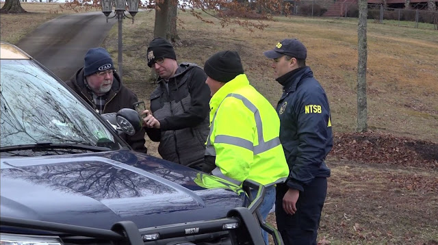
Federal officials are on scene to determine what happened in the crash and why, according to Adam Gerhardt, an air safety investigator with the National Transportation Safety Board.
One of the key pieces of the investigation involves determining if the four corners of the plane, the right and left wings, the nose and the tail, are at the accident site. Investigators are looking at the plane itself, the engine, the pilot and any challenges the pilot may have encountered and weather conditions at the time.
Investigators are working to determine what the weather conditions were like across the area to understand what the pilot encountered when the plane crashed.
According to Gerhardt, the plane left Indiana and made a refueling stop at the North Central West Virginia Airport in Bridgeport. The plane was then continuing on toward the Massachusetts area, although Gerhardt said it is uncertain which airport the pilot was flying to.
The plane’s direction of travel at the time of the crash is still under review, according to Gerhardt.
The plane was not equipped with a black box, and Gerhardt said it is not required to be. Investigators are looking for non-volatile memory, such as an iPad or GPS device, that could contain relevant data.
The NTSB and the Federal Aviation Administration will be on site for about three to five days. A recovery crew will take the airplane to Springfield, Tennessee to continue the investigation, Gerhardt said.
A preliminary report will be released in about 10 days. A final report will take between 12 and 18 months and will include the full factual and analysis and probable cause for the crash, according to Gerhardt.
The FAA is on site to assist the NTSB, with a focus on what regulatory items applied to the plane and to the flight. If there are any urgent safety recommendations, the two agencies can make any needed changes, said Gerhardt.
Gerhardt added that the whole reason for being on site is to prevent future accidents.
Story and video ➤ https://www.wboy.com

GRAFTON — An aircraft that crashed in Taylor County Monday afternoon was en route to Massachusetts from Indiana when the accident occurred, according to investigators.
The Aeropro CZ Model A220, described as a special light-sport aircraft, went down approximately 10 minutes after taking off from the North Central West Virginia Airport, where the pilot had stopped to refuel, according to National Transportation Safety Board spokesman Peter Knudson.
The accident occurred in Taylor County not far from the Marion County line in a wooded area near Valley Falls Road, according to a press release issued Monday evening by West Virginia State Police.
The pilot, who was the sole occupant of the plane, was killed, according to local law enforcement.
The identity of the deceased had not yet been released as of Tuesday afternoon, pending notification of next of kin, according to a representative of the West Virginia State Police.
The pilot was “not from this area,” said Taylor County Sheriff Terry Austin.
Along with State Police, first responders from Taylor and Marion counties responded to the accident scene on Monday afternoon.
The aircraft was “still smoldering with fire in the woods” when first responders arrived, according to the State Police press release.
NTSB investigators arrived at the “highly fragmented” crash scene around 8 a.m. Tuesday, according to Knudson.
North Central West Virginia Airport staff have been in contact with investigators and are assisting investigation efforts “anyway we can,” said North Central West Virginia Airport Director Rick Rock.
According to Rock, airport staff members interacted with the pilot and there was “nothing apparent” that was amiss at the time of the refueling.
“It’s a really unfortunate thing. Our hearts go out to the family and the first responders,” Rock said.
Investigators are not aware of any distress call from the pilot, nor did the pilot receive any air traffic control services, according to Knudson.
The pilot was flying under visual flight rules rather than instrument flight rules, and was therefore not required to have contact with air traffic control, he said.
An aircraft recovery company team is expected to arrive at the crash site on Wednesday, and on-site investigation and cleanup are expected to be completed by the afternoon, he said.
Preliminary radar data will also be used in the investigation, he said.
No eye or ear witnesses have yet come forward. Anyone who may have seen or heard the crash is asked to email witness@ntsb.gov.
A preliminary report on aircraft accidents is typically completed in the weeks following the crash, but a final report, including the cause and contributing factors, can take anywhere from 12 to 24 months to complete, Knudson said.
https://www.wvnews.com

A retired Baystate Medical Center neurosurgeon died Monday when he crashed his small private aircraft in a wooded section of West Virginia 10 miles south of the Pennsylvania line.
West Virginia state police identified the deceased as Thomas Kaye, 67, of the Haydenville section of Williamsburg, Massachusetts. He was the only occupant of the aircraft, according to WTAP news in Parkersburg, West Virginia.
He was killed Monday afternoon when his single-engine Aeropro A220 light-sport aircraft crashed in a wooded area near Grafton, West Virginia.
WVNews cites a National Transportation Safety Board official who said the plane was heading from Indiana to Massachusetts. It had stopped to refuel at North Central West Virginia Airport in Clarksburg, and then crashed around 10 minutes after resuming its flight.
Keith O’Connor, spokesman for Baystate Medical Center in Springfield, said Kaye worked at the hospital for nearly two decades as a neurosurgeon before he retired in 2018.
The crash is being investigated by West Virginia State Police and the NTSB.
https://www.masslive.com

TAYLOR COUNTY, West Virginia (WDTV) - UPDATE: 01/29/20 11:40 A.M.
West Virginia State Police have released the name of the man killed in a plane crash Monday.
Thomas Kaye, 67, of Haydenville, Massachusetts, was flying from Indiana to Massachusetts. He stopped at North Central West Virginia Airport to refuel shortly before crashing.
A NTSB spokesperson told 5 News investigators haven't found witnesses to the crash.
The debris field was “highly fragmented," Knudson said. The plane was an experimental Aeropro A220. Kaye did not send out a distress signal before crashing and didn't have air traffic control services like flight following, investigators learned.
NTSB crash investigators are expected to remain at the crash site until sometime Wednesday. A preliminary crash report could be finalized within one to two weeks, but the official investigation could take 12-24 months to complete.
Investigators want to talk to anyone who may have saw the plane crash. They should contact witness@NTSB.gov if they have information that could help the investigation.
https://www.wtap.com


TAYLOR COUNTY, W.Va. (WDTV)-- UPDATE 01/29/2020 @ 2:45 p.m.
A neurosurgeon based in New England was killed when the plane he was flying crashed in Taylor County Monday.
Dr. Thomas Kay worked with Trinity Health of New England Medical Group. Dr. Christopher Comey, the chair of the surgery department at Saint Francis Hospital and Medical Center, released a statement to 5 News regarding the death of his colleague:
"On Monday our community lost my friend and our colleague Dr. Tom Kaye to an aviation accident. I have known and worked with Tom for over 20 years and his kindness, focus on patient care, and willingness to assist other colleagues was unmatched.
"Tom was happily retired when I asked him to come on board to work with Dr. Michael Hill at Saint Mary's Hospital in Waterbury. He willingly returned to patient care with great skill and enthusiasm. Tom also spent some time at Saint Francis as things got set up in Waterbury.
"I received continual feedback that he was kind and patient when called at any hour of the day or night. Tom was truly a special person, and our community mourns his passing."
Kaye, who West Virginia State Police troopers said was from Haydenville, Massachusetts, went to medical school at the Albert Einstein College of Medicine in Bronx, New York.
NTSB investigators said he was flying to Massachusetts from Indiana. He refueled at the North Central West Virginia Airport in Clarksburg Monday afternoon. His plane crashed 10 minutes after takeoff from Clarksburg, investigators said. He didn't send a distress signal and it's not known what caused the crash.
The NTSB was expected to finish collecting evidence from the "highly fragmented" debris field near the Marion-Taylor County line Wednesday.
Anyone who may have seen the plane crash should contact witness@NTSB.gov if they have information that could help the investigation.
UPDATE 01/29/2020 @ 11:02 a.m.
The pilot killed in Monday's plane crash in Taylor County has been identified by West Virginia State Police.
Thomas Kaye, 67, of Haydenville, Massachusetts, was flying from Indiana to Massachusetts. He stopped at North Central West Virginia Airport to refuel shortly before crashing.
A NTSB spokesperson told 5 News investigators haven't found witnesses to the crash.
The debris field was “highly fragmented," Knudson said. The plane was an experimental Aeropro A220. Kaye did not send out a distress signal before crashing and didn't have air traffic control services like flight following, investigators learned.
NTSB crash investigators are expected to remain at the crash site until sometime Wednesday. A preliminary crash report could be finalized within one to two weeks, but the official investigation could take 12-24 months to complete.
Investigators want to talk to anyone who may have seen the plane crash. They should contact witness@NTSB.gov if they have information that could help the investigation.
ORIGINAL STORY
Investigators haven't found witnesses to Monday's plane crash in Taylor County, an NTSB spokesperson told 5 News.
The plane left Indiana and was en route to Massachusetts, according to Peter Knudson with the NTSB. It crashed near the Marion-Taylor County line 10 minutes after taking off from a fuel stop at the North Central West Virginia Airport in Clarksburg.
The debris field was “highly fragmented," Knudson said. The plane was an experimental Aeropro A220. The pilot did not send out a distress signal before crashing and didn't have air traffic control services like flight following, investigators learned.
NTSB crash investigators are expected to remain at the crash site until sometime Wednesday. A preliminary crash report could be finalized within one to two weeks, but the official investigation could take 12-24 months to complete.
The pilot's name hasn't been released.
Investigators want to talk to anyone who may have saw the plane crash. They should contact witness@NTSB.gov if they have information that could help the investigation.
Accident Number: ERA20FA088
Date & Time: 01/27/2020, 1255 EST
Registration: N214K
Aircraft: AEROPRO CZ A220
Injuries: 1 Fatal
Flight Conducted Under: Part 91: General Aviation - Personal
On January 27, 2020, about 1255 eastern standard time, an Aeropro CZ A220, N214K, was destroyed when it impacted trees and terrain while en route near Grafton, West Virginia. The private pilot was fatally injured. The airplane was operated by the pilot as a personal flight conducted under the provisions of Title 14 Code of Federal Regulations Part 91. There was no flight plan filed for the flight that originated from North Central West Virginia Airport (CKB), Clarksburg, West Virginia.
According to an employee of the business that sold the airplane to the accident pilot, the pilot arrived at Shawnee Field Airport (1I3), Bloomfield, Indiana on January 25, 2020, to take delivery of the newly manufactured airplane. He reported that the pilot completed multiple training flights with a flight instructor over the weekend and then departed for the cross-country flight to his home in Massachusetts about 0900 on the day of the accident.
According to fixed-based operator (FBO) employees and fuel receipt records, when the airplane arrived at CKB about 1220, the pilot informed the employees he was making a fuel stop and was on his way to Massachusetts. He added 16 gallons of fuel to the airplane and remarked that "your weather is bad" to one of the employees. He subsequently paid for his fuel, left the FBO building, and departed.
According to Leidos Flight Service, there was no record that the pilot received a weather briefing or filed flight plans on the day of the accident.
Review of preliminary Federal Aviation Administration (FAA) air traffic control (ATC) communications revealed that the pilot was given clearance by the CKB ATC tower to taxi and subsequently depart runway 21 under visual flight rules (VFR). The pilot departed the area to the northeast and there were no further communications with ATC.
Review of preliminary FAA radar track data revealed that the accident airplane departed runway 21 at 1246 and proceeded to climb to about 3,000 ft mean sea level (msl) on a heading of about 050° for 4 minutes. The airplane leveled off for about 1 minute, then re-entered a climb at an increased rate. Two minutes later, radar data depicted the airplane at 5,500 ft msl with an indicated groundspeed of 46 knots. Subsequently, the flight track showed the airplane complete a tight 180° left turn. The final radar data depicted the airplane about .25 nautical mile from the location of the main wreckage heading 212° at 5,100 ft msl with an indicated groundspeed of 105 knots.
According to FAA airman records, the pilot held a private pilot certificate with ratings for airplane single-engine land and instrument airplane. The pilot was issued an FAA third-class medical certificate June 5, 2018. A review of the pilot's logbook revealed the pilot had logged a total flight time of 967 hours, in which 5.3 hours were instructional hours in the accident airplane recorded on January 26, 2020. The pilot logged 25 and 8 hours in the past 90 and 30 days respectively. From August 8, 2019, to January 26, 2020, the pilot had logged 7 hours of actual instrument fight time and accumulated 16 instrument approaches. His most recent flight review was completed on September 8, 2018. Several pages of the pilot's logbook were damaged by the postcrash fire and were not legible.
According to FAA airworthiness records, the 2-seat, single-engine, high-wing special light sport (S-LSA) airplane was issued a special airworthiness certificate on January 23, 2020. It was powered by a Rotax 912 ULS 100-horsepower engine and was equipped with a BRS Aerospace Whole Aircraft Rescue Parachute System. According to a bill of sale and registration application, the pilot purchased and registered the airplane to himself on January 23, 2020.
 Figure 1: The Accident Airplane During Assembly in December 2019.
Rollison Light Sport Aircraft Inc
The initial impact point coincided with a tree, about 110 ft from where the main wreckage was located. The angle of descent from the top of the tree where the airplane first collided to the main wreckage was about -55° and oriented 175° true. The accident site elevation was about 1,480 ft msl. All major components of the airplane were found near the main wreckage. Flight control continuity could not be established due to the highly fragmented wreckage and postcrash fire that consumed most of the fuselage; however, fragments of each flight control surface, forward and rear wing spars, and wingtips were located with the main wreckage.
The cockpit, instrument panel, seats, and fuselage were largely consumed by the postcrash fire. A fragmented and fire damaged airspeed indicator was found indicating about 40 mph (35 knots). Several instrument casings were located, but each sustained significant fire damage. The main fuel shutoff valve was located in the debris and found selected to an on/open position. There was no evidence that the aircraft rescue parachute system had activated; however, the system was not identified in the postcrash fire debris.
The engine was located with the main wreckage, partially submerged in the terrain. It sustained heavy impact damage; the No. 2 cylinder was found partially submerged in terrain about 5 ft from the remainder of the engine. The propeller hub had fragmented into several pieces and all three propeller blades were located near the main wreckage. Each had fragmented into several pieces and separated from its hub. The carburetor sustained impact damage but remained partially connected to the engine. The butterfly valve was observed closed and could not be moved due to impact damage.
The 1253 recorded weather observation at CKB, which was located about 10 miles southwest of the accident site, included a broken ceiling at 1,800 ft above ground level (agl), an overcast ceiling at 2,300 ft agl, visibility 10 statute miles, wind 260° at 6 knots, temperature was 4° C, dew point -2° C, and an altimeter setting of 29.83 inches of mercury.
The 1253 recorded weather observation at Morgantown Municipal Airport (MGW), Morgantown, West Virginia, which was located about 16 miles north of the accident site, included an overcast ceiling of 2,100 ft agl, visibility 10 statute miles, wind 280° at 7 knots, temperature 3° C, dew point -2° C, and an altimeter setting of 29.82 inches of mercury. According to a first responder who observed the weather conditions at the accident site shortly after the accident, there was an overcast cloud layer, the temperature was about freezing, and there was an occasional flurry, but the visibility was "not an issue."
The wreckage was retained for further examination.
Aircraft and Owner/Operator Information
Aircraft Make: AEROPRO CZ
Registration: N214K
Model/Series: A220
Aircraft Category: Airplane
Amateur Built: No
Operator: On file
Operating Certificate(s) Held: None
Meteorological Information and Flight Plan
Conditions at Accident Site: Unknown
Condition of Light: Day
Observation Facility, Elevation: KCKB, 1203 ft msl
Observation Time: 1253 EST
Distance from Accident Site: 10 Nautical Miles
Temperature/Dew Point: 4°C / -2°C
Lowest Cloud Condition:
Wind Speed/Gusts, Direction: 6 knots / , 260°
Lowest Ceiling: Broken / 1800 ft agl
Visibility: 10 Miles
Altimeter Setting: 29.83 inches Hg
Type of Flight Plan Filed: None
Departure Point: Clarksburg, WV (CKB)
Destination:
Wreckage and Impact Information
Crew Injuries: 1 Fatal
Aircraft Damage: Destroyed
Passenger Injuries: N/A
Aircraft Fire: On-Ground
Ground Injuries: N/A
Aircraft Explosion: On-Ground
Total Injuries: 1 Fatal
Latitude, Longitude: 39.393056, -80.048889

Patients and former co-workers of Dr. Thomas Kaye are now sharing their memories of him.
Those who knew Dr. Kaye, who worked at Baystate for much of his career, say he was the type of doctor who took time out of his day to make sure his patients were comfortable.
"He had a way of making people not afraid of what was going on," local resident Jennifer Pecor tells us.
Investigators say neurosurgeon Dr. Thomas Kaye was flying to Massachusetts Monday afternoon in the plane he recently purchased came crashing down in West Virginia.
One of his former patients, Jennifer Pecor, tells Western Mass News not only did he operate on her when she was ten years old, but her daughter as well many years later.
"They told us she wasn't going to make it. Dr.Kaye and Dr. Oh had said they were actually going to operate on her. They basically saved her life. I’m pretty sure if it wasn't for him, she wouldn't be here today," stated Pecor.
She remembers him as a caring doctor who had a real impact on her family.
"When I was little, I was pretty terrified of a lot of things and a lot of surgeries, and he calmed my nerves and then when my daughter was in a cardiac arrest he was all sorts of jokes and laughter and calmed me when i was by myself terrified that she was going to die," explained Pecor.
Dr. Kaye worked at Baystate Medical Center for more than twenty years.
Chief of neurosurgery, Dennis Oh, says he looked up to him as a surgeon, because of how kind he was to patients and their families.
"He has a special touch of holding your hand and helping you get through the difficult episode of neurosurgical care for your child, so he was a pediatric neurosurgeon, but also treated adults. He treated everything," says Dr.Oh.
Dr. Oh says his former colleague will be greatly missed.
"It's devastating. I think, you know, when you lose someone of not just his magnitude, but his charisma and how widely loved as he was, it just shocks everyone," added Dr. Oh.
Dr. Kaye was the only person in the plane at the time of the crash.
He was 67-years-old.
Circumstances surrounding Monday's crash are still under investigation.
https://www.westernmassnews.com

GRAFTON, W.Va. (WBOY) – The Taylor County Detachment of the West Virginia State Police has released the name of the deceased pilot of the plane that crashed in Taylor County on Monday.
According to state police, the man has been identified as Thomas Kaye, 67, of Haydenville, Massachusetts. Kaye was a neurosurgeon at Baystate Medical Center in Massachusetts, until he retired in 2018, according to a spokesman at the medical center.
The Taylor County Sheriff’s Office believes Kaye has just purchased the plane and was flying it home when the accident occurred.
UPDATE (1/28/20 2:20 p.m.):
New information is available in a plane crash January 27 in Taylor County that killed one person.
The plane involved is an Aeropro CZ A220 registered to Rollison Light Sport Aircraft, Inc., which is based out of Bloomfield, Indiana. The registration number is N214K. This is a two-seat, single-engine propeller airplane that is typically used for recreational purposes.
Federal officials are on scene to determine what happened in the crash and why, according to Adam Gerhardt, an air safety investigator with the National Transportation Safety Board.
One of the key pieces of the investigation involves determining if the four corners of the plane, the right and left wings, the nose and the tail, are at the accident site. Investigators are looking at the plane itself, the engine, the pilot and any challenges the pilot may have encountered and weather conditions at the time.
Investigators are working to determine what the weather conditions were like across the area to understand what the pilot encountered when the plane crashed.
According to Gerhardt, the plane left Indiana and made a refueling stop at the North Central West Virginia Airport in Bridgeport. The plane was then continuing on toward the Massachusetts area, although Gerhardt said it is uncertain which airport the pilot was flying to.
The plane’s direction of travel at the time of the crash is still under review, according to Gerhardt.
The plane was not equipped with a black box, and Gerhardt said it is not required to be. Investigators are looking for non-volatile memory, such as an iPad or GPS device, that could contain relevant data.
The NTSB and the Federal Aviation Administration will be on site for about three to five days. A recovery crew will take the airplane to Springfield, Tennessee to continue the investigation, Gerhardt said.
A preliminary report will be released in about 10 days. A final report will take between 12 and 18 months and will include the full factual and analysis and probable cause for the crash, according to Gerhardt.
The FAA is on site to assist the NTSB, with a focus on what regulatory items applied to the plane and to the flight. If there are any urgent safety recommendations, the two agencies can make any needed changes, said Gerhardt.
Gerhardt added that the whole reason for being on site is to prevent future accidents.
Story and video ➤ https://www.wboy.com

GRAFTON — An aircraft that crashed in Taylor County Monday afternoon was en route to Massachusetts from Indiana when the accident occurred, according to investigators.
The Aeropro CZ Model A220, described as a special light-sport aircraft, went down approximately 10 minutes after taking off from the North Central West Virginia Airport, where the pilot had stopped to refuel, according to National Transportation Safety Board spokesman Peter Knudson.
The accident occurred in Taylor County not far from the Marion County line in a wooded area near Valley Falls Road, according to a press release issued Monday evening by West Virginia State Police.
The pilot, who was the sole occupant of the plane, was killed, according to local law enforcement.
The identity of the deceased had not yet been released as of Tuesday afternoon, pending notification of next of kin, according to a representative of the West Virginia State Police.
The pilot was “not from this area,” said Taylor County Sheriff Terry Austin.
Along with State Police, first responders from Taylor and Marion counties responded to the accident scene on Monday afternoon.
The aircraft was “still smoldering with fire in the woods” when first responders arrived, according to the State Police press release.
NTSB investigators arrived at the “highly fragmented” crash scene around 8 a.m. Tuesday, according to Knudson.
North Central West Virginia Airport staff have been in contact with investigators and are assisting investigation efforts “anyway we can,” said North Central West Virginia Airport Director Rick Rock.
According to Rock, airport staff members interacted with the pilot and there was “nothing apparent” that was amiss at the time of the refueling.
“It’s a really unfortunate thing. Our hearts go out to the family and the first responders,” Rock said.
Investigators are not aware of any distress call from the pilot, nor did the pilot receive any air traffic control services, according to Knudson.
The pilot was flying under visual flight rules rather than instrument flight rules, and was therefore not required to have contact with air traffic control, he said.
An aircraft recovery company team is expected to arrive at the crash site on Wednesday, and on-site investigation and cleanup are expected to be completed by the afternoon, he said.
Preliminary radar data will also be used in the investigation, he said.
No eye or ear witnesses have yet come forward. Anyone who may have seen or heard the crash is asked to email witness@ntsb.gov.
A preliminary report on aircraft accidents is typically completed in the weeks following the crash, but a final report, including the cause and contributing factors, can take anywhere from 12 to 24 months to complete, Knudson said.
https://www.wvnews.com

West Virginia state police identified the deceased as Thomas Kaye, 67, of the Haydenville section of Williamsburg, Massachusetts. He was the only occupant of the aircraft, according to WTAP news in Parkersburg, West Virginia.
He was killed Monday afternoon when his single-engine Aeropro A220 light-sport aircraft crashed in a wooded area near Grafton, West Virginia.
WVNews cites a National Transportation Safety Board official who said the plane was heading from Indiana to Massachusetts. It had stopped to refuel at North Central West Virginia Airport in Clarksburg, and then crashed around 10 minutes after resuming its flight.
Keith O’Connor, spokesman for Baystate Medical Center in Springfield, said Kaye worked at the hospital for nearly two decades as a neurosurgeon before he retired in 2018.
The crash is being investigated by West Virginia State Police and the NTSB.
https://www.masslive.com

TAYLOR COUNTY, West Virginia (WDTV) - UPDATE: 01/29/20 11:40 A.M.
West Virginia State Police have released the name of the man killed in a plane crash Monday.
Thomas Kaye, 67, of Haydenville, Massachusetts, was flying from Indiana to Massachusetts. He stopped at North Central West Virginia Airport to refuel shortly before crashing.
A NTSB spokesperson told 5 News investigators haven't found witnesses to the crash.
The debris field was “highly fragmented," Knudson said. The plane was an experimental Aeropro A220. Kaye did not send out a distress signal before crashing and didn't have air traffic control services like flight following, investigators learned.
NTSB crash investigators are expected to remain at the crash site until sometime Wednesday. A preliminary crash report could be finalized within one to two weeks, but the official investigation could take 12-24 months to complete.
Investigators want to talk to anyone who may have saw the plane crash. They should contact witness@NTSB.gov if they have information that could help the investigation.
https://www.wtap.com


A neurosurgeon based in New England was killed when the plane he was flying crashed in Taylor County Monday.
Dr. Thomas Kay worked with Trinity Health of New England Medical Group. Dr. Christopher Comey, the chair of the surgery department at Saint Francis Hospital and Medical Center, released a statement to 5 News regarding the death of his colleague:
"On Monday our community lost my friend and our colleague Dr. Tom Kaye to an aviation accident. I have known and worked with Tom for over 20 years and his kindness, focus on patient care, and willingness to assist other colleagues was unmatched.
"Tom was happily retired when I asked him to come on board to work with Dr. Michael Hill at Saint Mary's Hospital in Waterbury. He willingly returned to patient care with great skill and enthusiasm. Tom also spent some time at Saint Francis as things got set up in Waterbury.
"I received continual feedback that he was kind and patient when called at any hour of the day or night. Tom was truly a special person, and our community mourns his passing."
Kaye, who West Virginia State Police troopers said was from Haydenville, Massachusetts, went to medical school at the Albert Einstein College of Medicine in Bronx, New York.
NTSB investigators said he was flying to Massachusetts from Indiana. He refueled at the North Central West Virginia Airport in Clarksburg Monday afternoon. His plane crashed 10 minutes after takeoff from Clarksburg, investigators said. He didn't send a distress signal and it's not known what caused the crash.
The NTSB was expected to finish collecting evidence from the "highly fragmented" debris field near the Marion-Taylor County line Wednesday.
Anyone who may have seen the plane crash should contact witness@NTSB.gov if they have information that could help the investigation.
UPDATE 01/29/2020 @ 11:02 a.m.
The pilot killed in Monday's plane crash in Taylor County has been identified by West Virginia State Police.
Thomas Kaye, 67, of Haydenville, Massachusetts, was flying from Indiana to Massachusetts. He stopped at North Central West Virginia Airport to refuel shortly before crashing.
A NTSB spokesperson told 5 News investigators haven't found witnesses to the crash.
The debris field was “highly fragmented," Knudson said. The plane was an experimental Aeropro A220. Kaye did not send out a distress signal before crashing and didn't have air traffic control services like flight following, investigators learned.
NTSB crash investigators are expected to remain at the crash site until sometime Wednesday. A preliminary crash report could be finalized within one to two weeks, but the official investigation could take 12-24 months to complete.
Investigators want to talk to anyone who may have seen the plane crash. They should contact witness@NTSB.gov if they have information that could help the investigation.
ORIGINAL STORY
Investigators haven't found witnesses to Monday's plane crash in Taylor County, an NTSB spokesperson told 5 News.
The plane left Indiana and was en route to Massachusetts, according to Peter Knudson with the NTSB. It crashed near the Marion-Taylor County line 10 minutes after taking off from a fuel stop at the North Central West Virginia Airport in Clarksburg.
The debris field was “highly fragmented," Knudson said. The plane was an experimental Aeropro A220. The pilot did not send out a distress signal before crashing and didn't have air traffic control services like flight following, investigators learned.
NTSB crash investigators are expected to remain at the crash site until sometime Wednesday. A preliminary crash report could be finalized within one to two weeks, but the official investigation could take 12-24 months to complete.
The pilot's name hasn't been released.
Investigators want to talk to anyone who may have saw the plane crash. They should contact witness@NTSB.gov if they have information that could help the investigation.
Subscribe to:
Posts (Atom)


