Wednesday, March 16, 2022

ICON A5, N288PJ: Incident occurred March 16, 2022 in Granite Shoals, Burnet County, Texas

Federal Aviation Administration / Flight Standards District Office; San Antonio, Texas

Aircraft gear was not up while landing on the Colorado River damaging the landing gear. 


Date: 16-MAR-22
Time: 15:10:00Z
Regis#: N288PJ
Aircraft Make: ICON
Aircraft Model: A5
Event Type: INCIDENT
Highest Injury: NONE
Aircraft Missing: No
Damage: UNKNOWN
Activity: PERSONALFlight Phase: LANDING (LDG)
Operation: 91
City: GRANITE SHOALS
State: TEXAS


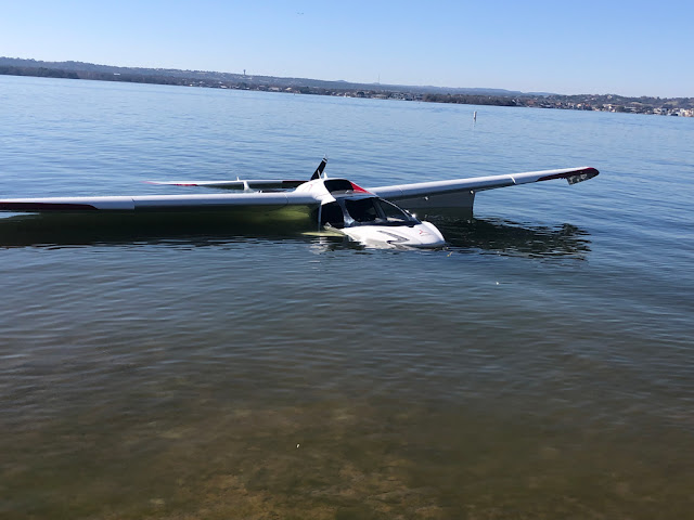
A ICON A5 aircraft landed gear down into Lake Lyndon B. Johnson on Wednesday, March 16, resulting in damage to the plane but no injuries to the pilot, a Kingsland resident.

“A gentleman from the Shirley Williams Airport in Kingsland, where he keeps his plane, was landing on Lake Lyndon B. Johnson,” Granite Shoals Fire Chief Tim Campbell told DailyTrib.com. “It’s the kind of plane that lands on both water and land, and he forgot to retract the landing gear for a water landing.”

When the plane hit the lake, it nosedived, breaking the windshield and filling with water, Campbell said. As it started to sink, a passerby helped get the pilot safely out then tied a rope to the aircraft and dragged it to shore.

Granite Shoals Fire and Rescue, the Granite Shoals and Marble Falls police departments, and Granite Shoals EMS all assisted. The case will be turned over to the Texas Department of Public Safety and then to the Federal Aviation Administration. 

“We didn’t have to do a lot,” Campbell said. “We used some of our ropes to tie it off so it wouldn’t float off and be an obstacle out in the middle of the lake.” 

The plane was secured next to 2510 Belair East Lane until a tow truck hauled it off. The Icon A5 light sport plane has retractable wings, which were folded up and out of the way so it could be towed. It is a two-person plane, but only the pilot was onboard at the time. 

Bombardier Challenger 300 N303JE: Incident occurred March 17, 2022 at George Bush Intercontinental Airport (KIAH), Houston, Texas

Federal Aviation Administration / Flight Standards District Office; Houston, Texas

Aircraft experienced smoke in the cargo hold, diverted to George Bush Intercontinental Airport (KIAH), landed and the fire was extinguished. 

1384 Charter LLC


Date: 17-MAR-22
Time: 19:03:00Z
Regis#: N303JE
Aircraft Make: BOMBARDIER
Aircraft Model: BD-100-1A10
Event Type: INCIDENT
Highest Injury: NONE
Aircraft Missing: No
Damage: FIRE
Activity: UNKNOWN
Flight Phase: EN ROUTE (ENR)
Operation: 91
City: HOUSTON
State: TEXAS

Controlled Flight into Terrain: Cirrus SR22, N7GA; fatal accident occurred November 26, 2019 in North Las Vegas, Nevada

Gregory Steven Akers

Valeriya Anatoliivna Slyzko

Nina Victorovna Morozova


Aviation Accident Final Report - National Transportation Safety Board

The National Transportation Safety Board traveled to the scene of this accident.

Additional Participating Entities: 
Federal Aviation Administration / Flight Standards District Office; Las Vegas, Nevada 
Cirrus Aircraft; Duluth, Minnesota 
Continental Motors Inc; Mobile, Alabama

Investigation Docket - National Transportation Safety Board:


Location: North Las Vegas, Nevada 
Accident Number: WPR20FA034
Date and Time: November 26, 2019, 17:30 Local
Registration: N7GA
Aircraft: Cirrus SR-22 
Aircraft Damage: Destroyed
Defining Event: Controlled flight into terr/obj (CFIT)
Injuries: 3 Fatal
Flight Conducted Under: Part 91: General aviation - Personal

Analysis

The pilot was conducting a visual flight rules (VFR) personal flight with two passengers during dark night conditions. Prior to the flight, the pilot had filed and subsequently activated a VFR flight plan from his point of departure to his intended destination.

As the pilot neared his intended destination, he contacted Nellis Air Traffic Control Facility and reported his altitude of 6,500 ft and that he had the weather at his destination airport. He also requested a practice instrument landing system (ILS) approach. The controller acknowledged the request and advised the pilot to expect the ILS approach. Throughout the following 7 minutes, the controller issued various heading changes to the pilot due to departing traffic at a nearby Air Force base, which the pilot acknowledged. The controller then issued the pilot a left turn to a westerly heading and informed the pilot that altitude was his discretion, which the pilot acknowledged.

About 1 minute, 54 seconds later, the pilot transmitted “we’re getting a low altitude alert for N7GA, we gotta turn left.” Shortly after, the controller instructed the pilot to “turn left heading 250°,” which the pilot acknowledged. No further communications from the pilot were received despite multiple attempts from the controller. Throughout this timeframe, recorded radar data showed the airplane at an altitude of 6,500 ft msl.

The airplane impacted mountainous terrain at an elevation of 6,500 ft msl, about 400 ft below the peak. The wreckage was fragmented and mostly consumed by fire. Examination revealed no anomalies with the airframe or engine that would have precluded normal operation.

Based on the available evidence, it is likely that the pilot had some sort of terrain awareness warning available; however, it was undetermined what type of system it was. While the pilot reported that he received a “low altitude alert” from an unknown source about 22 seconds before the last radar target, it’s likely that the pilot did not have sufficient time to maneuver to avoid terrain.

Probable Cause and Findings

The National Transportation Safety Board determines the probable cause(s) of this accident to be:
The pilot’s failure to maintain clearance from terrain during cruise flight in dark night conditions.

Findings

Personnel issues Monitoring environment - Pilot
Aircraft Altitude - Not attained/maintained
Personnel issues Use of equip/system - Pilot
Environmental issues Dark - Effect on operation
Environmental issues Mountainous/hilly terrain - Not specified

Factual Information

History of Flight

Enroute-cruise Controlled flight into terr/obj (CFIT) (Defining event)

On November 26, 2019, about 1730 Pacific standard time, a Cirrus SR-22 airplane, N7GA, was destroyed when it was involved in an accident near North Las Vegas, Nevada. The pilot and 2 passengers were fatally injured. The airplane was operated as a Title 14 Code of Federal Regulations Part 91 personal flight.

The pilot filed and activated a visual flight rules flight plan from his departure airport of Lake Havasu City Airport (HII), Lake Havasu, Arizona, to his intended destination of North Las Vegas Airport (VGT), North Las Vegas, Nevada.

Review of recorded communication and transcripts revealed that, at 1720:23, the pilot contacted Nellis Air Traffic Control Facility and reported an altitude of 6,500 ft and that he had “information papa.” The controller advised the pilot that the transmission was “broken” and confirmed that the pilot had information papa. The pilot responded that he had information papa for North Las Vegas and requested a practice instrument landing system (ILS) approach to runway 12 left. The controller acknowledged and informed the pilot to expect the ILS approach.

At 1723:48, the controller instructed the pilot to turn left heading 270° due to a departure of a flight of four F-35s, which were climbing through 2,200 ft, which the pilot acknowledged. At 1724:40, the controller instructed the pilot to turn left heading 240°, which the pilot read back; he also stated that he had [in sight] the last F-35 off the departure end. At 1725:30, the controller instructed the pilot to fly heading 280°, which the pilot acknowledged. The controller then advised the pilot that a flight of four F-22s would be departing runway 21 and climbing to the north. The pilot responded that he was searching. At 1726:03, the pilot asked the controller to verify that the F-22s were departing runway 21. The controller responded affirmative and subsequently instructed the pilot to fly a heading of 310° and advised the pilot that the F-22s were departing. The pilot read back his instruction.

At 1726:54, the controller instructed the pilot to turn right heading 360°, which the pilot acknowledged. At 1727:58, the controller instructed the pilot to turn left heading 270°, which the pilot acknowledged. Five seconds later, the controller instructed the pilot, “N7GA, altitude your discretion,” which the pilot responded with his call sign. At 1729:52, the pilot stated, “we’re getting a low altitude alert for N7GA, we gotta turn left.” Shortly after, the controller instructed the pilot to “turn left heading 250°,” which the pilot acknowledged. No further communications from the pilot were received despite multiple attempts from the controller.

Recorded radar data showed a flight track consistent with communication between the pilot and the controller. From 1727:28 to 1730:14, the radar data showed the airplane on a westnorthwesterly heading at an altitude of about 6,500 ft msl, with a groundspeed varying between 161 knots and 171 knots until radar contact was lost in the area of Gass Peak.

Pilot Information

Certificate: Private
Age: 60, Male
Airplane Rating(s): Single-engine land
Seat Occupied: Unknown
Other Aircraft Rating(s): None
Restraint Used: Unknown
Instrument Rating(s): Airplane 
Second Pilot Present: No
Instructor Rating(s): None
Toxicology Performed: Yes
Medical Certification: Class 3 With waivers/limitations 
Last FAA Medical Exam: February 22, 2019
Occupational Pilot: No 
Last Flight Review or Equivalent: April 27, 2019
Flight Time: 446.7 hours (Total, all aircraft), 123.6 hours (Total, this make and model), 35.5 hours (Last 90 days, all aircraft), 7 hours (Last 30 days, all aircraft)

The pilot’s personal logbook was not located. However, a digital logbook was obtained from ForeFlight, which contained logbook entries between April 20, 1986, through November 12, 2019, for a total of 246.5 hours of flight experience. The pilot reported on his most recent Federal Aviation Administration (FAA) medical application, dated February 22, 2019, he had accumulated 446.7 hours of flight experience, of which 2.4 hours were in the previous 6 months. Additionally, the pilot and airplane were based at VGT.

Aircraft and Owner/Operator Information

Aircraft Make: Cirrus
Registration: N7GA
Model/Series: SR-22 
Aircraft Category: Airplane
Year of Manufacture: 2001
Amateur Built:
Airworthiness Certificate: Normal
Serial Number: 00015
Landing Gear Type: Tricycle
Seats: 4
Date/Type of Last Inspection: Unknown
Certified Max Gross Wt.: 3600 lbs
Time Since Last Inspection: 
Engines: 1 Reciprocating
Airframe Total Time: 
Engine Manufacturer: Continental
ELT: C126 installed, activated, did not aid in locating accident
Engine Model/Series: IO-550-N
Registered Owner:
Rated Power: 310 Horsepower
Operator: On file 
Operating Certificate(s) Held: None

The airplane was equipped with an Aspen PDF1000 Pro display, which was not equipped with terrain avoidance alerts. Additionally, the airplane was equipped with a Avidyne FlightMax EX5000C multi-function color display. It was not determined if the EX5000C was configured with an optional terrain awareness warning system.

The pilot had a ForeFlight Pro Plus subscription for their electronic flight book application. Per representatives from ForeFlight, based upon his subscription, the pilot would have had access to the Hazard Advisor feature of the application, however, it would have required an Apple iPad to either have a cellular option or external GPS for location reference. The pilot also had access to the Synthetic Vision feature of the application, which would have required the use a compatible altitude and heading reference system (AHRS) device.

Meteorological Information and Flight Plan

Conditions at Accident Site: Visual (VMC) 
Condition of Light: Night/dark
Observation Facility, Elevation: KVGT, 2203 ft msl 
Distance from Accident Site: 11 Nautical Miles
Observation Time: 00:53 Local 
Direction from Accident Site: 184°
Lowest Cloud Condition: Clear
Visibility: 10 miles
Lowest Ceiling: None
Visibility (RVR):
Wind Speed/Gusts: 6 knots /
Turbulence Type Forecast/Actual: None / None
Wind Direction: 110° 
Turbulence Severity Forecast/Actual: N/A / N/A
Altimeter Setting: 29.86 inches Hg 
Temperature/Dew Point: 8°C / -10°C
Precipitation and Obscuration: No Obscuration; No Precipitation
Departure Point: Lake Havasu, AZ 
Type of Flight Plan Filed: VFR/IFR
Destination: North Las Vegas, NV (VGT) 
Type of Clearance: VFR
Departure Time: 16:43 Local
Type of Airspace: Class B

Official sunset occurred at 1627 with end of civil twilight at 1655. The moon was in a new moon phase.

Airport Information

Airport: NORTH LAS VEGAS VGT
Runway Surface Type:
Airport Elevation: 2205 ft msl
Runway Surface Condition: Unknown
Runway Used: 
IFR Approach: None
Runway Length/Width:
VFR Approach/Landing: None

Wreckage and Impact Information

Crew Injuries: 1 Fatal
Aircraft Damage: Destroyed
Passenger Injuries: 2 Fatal
Aircraft Fire: None
Ground Injuries:
Aircraft Explosion: None
Total Injuries: 3 Fatal
Latitude, Longitude: 36.400001,-115.18083

Examination of the accident site by representatives of the FAA revealed that the airplane impacted terrain about 400 ft below the summit of Gass Peak in the vicinity of the last recorded radar target at an elevation of about 6,500 ft mean sea level. The wreckage was fragmented and mostly consumed by a postimpact fire.

Examination of the recovered airframe and engine revealed no evidence of any preexisting mechanical malfunction that would have precluded normal operation.

Additional Information

Federal Aviation Administration (FAA) order JO 7110.65Y, Air Traffic Control, paragraph 7-6-1. “Application” described basic radar services that controllers provided to a VFR aircraft.

The paragraph stated in part:

a. Basic radar services for VFR aircraft must include:

1. Safety alerts.
2. Traffic advisories.
3. Limited radar vectoring when requested by the pilot.
4. Sequencing at locations where procedures have been established for this purpose and/or when covered by a LOA [Letter of Agreement].

FAA order JO 7110.65Y, Air Traffic Control, paragraph 2-1-6, “Safety Alert,” described procedures and circumstances when controllers would provide a safety alert to a pilot. 

The paragraph stated in part:

Issue a safety alert to an aircraft if you are aware the aircraft is in a position/altitude that, in your judgment, places it in unsafe proximity to terrain, obstructions, or other aircraft. Once the pilot informs you action is being taken to resolve the situation, you may discontinue the issuance of further alerts. Do not assume that because someone else has responsibility for the aircraft that the unsafe situation has been observed and the safety alert issued; inform the appropriate controller.

NOTE-1. The issuance of a safety alert is a first priority…once the controller observes and recognizes a situation of unsafe aircraft proximity to terrain, obstacles, or other aircraft. Conditions, such as workload, traffic volume, the quality/limitations of the radar system, and the available lead time to react are factors in determining whether it is reasonable for the controller to observe and recognize such situations. While a controller cannot see immediately the development of every situation where a safety alert must be
issued, the controller must remain vigilant for such situations and issue a safety alert when the situation is recognized.

Aeronautical Information Manual (AIM), paragraph 4-1-18, “Terminal Radar Services for VFR Aircraft,” described the pilot’s responsibilities when operating VFR and receiving radar services.

The paragraph stated in part:

e. PILOT RESPONSIBILITY. These services are not to be interpreted as relieving pilots of their responsibilities to see and avoid other traffic operating in basic VFR weather conditions, to adjust their operations and flight path as necessary to preclude serious wake encounters, to maintain appropriate terrain and obstruction clearance, or to remain in weather conditions equal to or better than the minimums required by 14 CFR section 91.155. Whenever compliance with an assigned route, heading and/or altitude is likely to compromise pilot responsibility respecting terrain and obstruction clearance, vortex exposure, and weather minimums, approach control should be so advised, and a revised clearance or instruction obtained.

Gregory Steven Akers, age 60, passed away tragically November 26th 2019 in a plane crash on Gass Peak north of Las Vegas along with his wife Valeriya Slyzko and mother-in-law Nina Victorovna Morozova. He began his passion for flying in 1981, which led to his career as an Air Traffic Controller starting in Dallas/Ft Worth, Texas and retiring in 2015 from MaCarren International Air Port, Las Vegas, Nevada.

Gregory was born in 1959 at Shaw AFB, South Carolina. As a Military Brat he lived in Ft. Walton Beach, Florida, Tampa, Florida, Medenbach, Germany, Wiesbaden, Germany and Universal City Texas. He attended Wiesbaden Highschool and Judson Highschool. He enjoyed going back to Wiesbaden which he considered home and he travelled throughout Europe extensively. He was passionate about flying, fast cars, and photography the latter which became his profession after retiring from the FAA.

Gregory is survived by his father, William Akers; brother Jeff Akers and sister in law Terry Akers, nephew Jack Akers, ex-wife Ilia Akers, his beloved Chihuahua puppies Billy, Heidi, and Olav; numerous cousins and many, many friends who will miss him immensely.

Gregory was preceded in death by his mother Chris Akers. Mass will be held for Greg, Valeriya and Nina at 10:00 am, Friday December 20th 2019 at St Peter the Apostle, 204 South Boulder Hwy, Henderson Nevada and Memorial Service on Saturday December 21st 2019 at 2:00pm with a Missing Man Flyover at 2:30pm, at Davis Funeral Home, 6200 South Eastern Ave, Las Vegas, Nevada.

Valeriya Anatoliivna Slyzko, age 48, passed away tragically November 26th 2019 in a plane crash on Gass Peak north of Las Vegas along with her husband Greg Akers and mother Nina Victorovna Morozova. Valeriya was born in 1971 in Kadiivka City, Ukraine. She moved to Dallas, Texas in 1997 and married Greg in 1998, where they lived till moving to Henderson, Nevada in 2003.

Valeriya worked for the United States Postal Service processing office where she had many friends where all say they were blessed to have known her. She was known as a very kind person who always had a smile, who loved everybody, defended everybody and never had a bad word to say about anyone.

Valeriya is survived by her father in law, William Akers; brother in law Jeff Akers and sister in law Terry Akers, nephew Jack Akers, her beloved Chihuahua puppies Billy, Heidi, and Olav; and many, many friends who will miss her immensely. Mass will be held for Valeriya at 10:00 am, Friday December 20th 2019 at St Peter the Apostle, 204 South Boulder Hwy, Henderson Nevada and Memorial Service on Saturday December 21st 2019 at 2:00pm, at Davis Funeral Home, 6200 South Eastern Ave, Las Vegas, Nevada.

Nina Victorovna Morozova, age 71, passed away tragically November 26th 2019 in a plane crash on Gass Peak north of Las Vegas along with her daughter Valeriya Anatoliivna Slyzko and son in law Greg Akers. 

Nina was born 1948 in Ukraine. She moved to Henderson, Nevada with her daughter and son in law in 2015. She was known as a very kind person by all who knew her and her neighbors who spoke fondly of her remember her daily walks with their puppies. Mass will be held for Nina at 10:00 am, Friday December 20th 2019 at St Peter the Apostle, 204 South Boulder Hwy, Henderson Nevada and Memorial Service on Saturday December 21st 2019 at 2:00pm at Davis Funeral Home, 6200 South Eastern Ave, Las Vegas, Nevada.

Collision During Landing: Piper PA22-150, N6755B; accident occurred March 07, 2022 at Boundary County Airport (65S), Bonners Ferry, Idaho


Aviation Accident Final Report - National Transportation Safety Board

Additional Participating Entity:
Federal Aviation Administration / Flight Standards District Office; Spokane, Washington

The National Transportation Safety Board did not travel to the scene of this accident.

Investigation Docket - National Transportation Safety Board:


Location: Bonners Ferry, Idaho
Accident Number: WPR22LA118
Date and Time: March 7, 2022, 18:30 Local
Registration: N6755B
Aircraft: Piper PA-22-150
Aircraft Damage: Substantial
Defining Event: Collision during takeoff/land
Injuries: 1 None
Flight Conducted Under: Part 91: General aviation - Personal

Analysis

The pilot of the tailwheel equipped airplane reported that, during the landing the airplane bounced, he added power and landed a second time about halfway down the runway. Subsequently, he lost directional control which resulted in a ground loop and runway excursion. The left wing, left horizontal stabilizer and left elevator were substantially damaged.

The pilot reported no preaccident mechanical malfunctions or failures with the airplane that would have precluded normal operation.

Probable Cause and Findings

The National Transportation Safety Board determines the probable cause(s) of this accident to be:
The pilot’s improper landing flare, and bounced landing, which resulted in a ground loop and runway excursion.

Findings

Personnel issues Aircraft control - Pilot
Aircraft Directional control - Not attained/maintained
Aircraft Landing flare - Not attained/maintained

Factual Information

History of Flight

Landing-flare/touchdown Collision during takeoff/land (Defining event)

Pilot Information

Certificate: Private
Age: 35,Male
Airplane Rating(s): Single-engine land; Single-engine sea
Seat Occupied: Left
Other Aircraft Rating(s): None 
Restraint Used: None
Instrument Rating(s): None
Second Pilot Present:
Instructor Rating(s): None 
Toxicology Performed:
Medical Certification: Class 3 Without waivers/limitations
Last FAA Medical Exam: March 3, 2021
Occupational Pilot: No 
Last Flight Review or Equivalent: June 8, 2021
Flight Time: (Estimated) 138 hours (Total, all aircraft), 28.6 hours (Total, this make and model), 82 hours (Pilot In Command, all aircraft), 28.6 hours (Last 90 days, all aircraft), 19.8 hours (Last 30 days, all aircraft), 6.1 hours (Last 24 hours, all aircraft)

Aircraft and Owner/Operator Information

Aircraft Make: Piper
Registration: N6755B
Model/Series: PA-22-150 NO SERIES 
Aircraft Category: Airplane
Year of Manufacture: 1956
Amateur Built:
Airworthiness Certificate: None
Serial Number: 22-4089
Landing Gear Type: Tailwheel 
Seats: 4
Date/Type of Last Inspection: June 16, 2021 Annual
Certified Max Gross Wt.: 1800 lbs
Time Since Last Inspection: 35 Hrs
Engines: 1 Reciprocating
Airframe Total Time: 2116 Hrs at time of accident
Engine Manufacturer: Lycoming
ELT: C91A installed, not activated 
Engine Model/Series: O-320-A1A
Registered Owner:
Rated Power: 150 Horsepower
Operator: 
Operating Certificate(s) Held: None

Meteorological Information and Flight Plan

Conditions at Accident Site: Visual (VMC)
Condition of Light: Night
Observation Facility, Elevation: 2337 ft msl 
Distance from Accident Site: 0 Nautical Miles
Observation Time: 18:30 Local
Direction from Accident Site: 0°
Lowest Cloud Condition: Scattered / 5000 ft AGL
Visibility: 
Lowest Ceiling: Broken 
Visibility (RVR):
Wind Speed/Gusts: 5 knots / 
Turbulence Type Forecast/Actual: Unknown / Unknown
Wind Direction: 300° 
Turbulence Severity Forecast/Actual: Unknown / Unknown
Altimeter Setting: 
Temperature/Dew Point: 2.2°C
Precipitation and Obscuration:
Departure Point: Salmon, ID (SMN) 
Type of Flight Plan Filed: None
Destination: Bonners Ferry, ID
Type of Clearance: None
Departure Time: 15:50 Local 
Type of Airspace: Class E

Airport Information

Airport: Boundary County Airport 65S 
Runway Surface Type: Asphalt
Airport Elevation: 2337 ft msl
Runway Surface Condition: Dry
Runway Used: 02
IFR Approach: None
Runway Length/Width: 4000 ft / 75 ft 
VFR Approach/Landing:

Wreckage and Impact Information

Crew Injuries: 1 None
Aircraft Damage: Substantial
Passenger Injuries:
Aircraft Fire: None
Ground Injuries:
Aircraft Explosion: None
Total Injuries: 1 None
Latitude, Longitude: 48.726447,-116.2946(est)


Location: Bonners Ferry, Idaho
Accident Number: WPR22LA118
Date and Time: March 7, 2022, 18:30 Local 
Registration: N6755B
Aircraft: Piper PA-22-150 
Injuries: 1 None
Flight Conducted Under: Part 91: General aviation - Personal

Aircraft and Owner/Operator Information

Aircraft Make: Piper
Registration: N6755B
Model/Series: PA-22-150 
Aircraft Category: Airplane
Amateur Built:
Operator: 
Operating Certificate(s) Held: None
Operator Designator Code:

Meteorological Information and Flight Plan

Conditions at Accident Site:
Condition of Light:
Observation Facility, Elevation: 
Observation Time:
Distance from Accident Site: 
Temperature/Dew Point:
Lowest Cloud Condition: 
Wind Speed/Gusts, Direction: / ,
Lowest Ceiling: Visibility:
Altimeter Setting: 
Type of Flight Plan Filed:
Departure Point: 
Destination:

Wreckage and Impact Information

Crew Injuries: 1 None
Aircraft Damage: Substantial
Passenger Injuries: 
Aircraft Fire: None
Ground Injuries:
Aircraft Explosion: None
Total Injuries: 1 None 
Latitude, Longitude: 48.726447,-116.2946 (est)

Aircraft on landing, lost control, ground looped and struck a snowbank. 

Date: 08-MAR-22
Time: 02:30:00Z
Regis#: N6755B
Aircraft Make: PIPER
Aircraft Model: PA22
Event Type: INCIDENT
Highest Injury: NONE
Aircraft Missing: No
Damage: MINOR
Activity: PERSONAL
Flight Phase: LANDING (LDG)
Operation: 91
City: BONNERS FERRY
State: IDAHO

Loss of Control on Ground: TBM 850, N755ZR; accident occurred March 11, 2022 at Taylorville Municipal Airport (KTAZ), Christian County, Illinois


Aviation Accident Final Report - National Transportation Safety Board

The National Transportation Safety Board did not travel to the scene of this accident. 

Additional Participating Entity:
Federal Aviation Administration / Flight Standards District Office; Springfield, Illinois

Investigation Docket - National Transportation Safety Board: https://data.ntsb.gov/Docket


Location: Taylorville, Illinois 
Accident Number: CEN22LA143
Date and Time: March 11, 2022, 15:05 Local 
Registration: N755ZR
Aircraft: Socata TBM 700
Aircraft Damage: Substantial
Defining Event: Loss of control on ground
Injuries: 4 None
Flight Conducted Under: Part 91: General aviation - Personal

Analysis

The pilot reported that the airplane encountered a crosswind gust during the landing roll and subsequently departed the left side of the runway pavement. The left main and nose landing gear sunk into the soft ground adjacent to the runway which resulted in substantial damage to the engine mount.

The pilot stated that there were no preaccident mechanical failures or malfunctions with the airplane that would have precluded normal operation.

Probable Cause and Findings

The National Transportation Safety Board determines the probable cause(s) of this accident to be:
The pilot’s failure to maintain directional control during the landing roll in gusting wind conditions.

Findings

Personnel issues Aircraft control - Pilot
Aircraft Directional control - Not attained/maintained
Environmental issues Crosswind - Effect on operation

Factual Information

History of Flight

Landing-landing roll Other weather encounter
Landing-landing roll Loss of control on ground (Defining event)
Landing-landing roll Runway excursion

Pilot Information

Certificate: Private 
Age: 50, Male
Airplane Rating(s): Single-engine land
Seat Occupied: Left
Other Aircraft Rating(s): None
Restraint Used: 4-point
Instrument Rating(s): Airplane
Second Pilot Present: No
Instructor Rating(s): None 
Toxicology Performed: No
Medical Certification: Class 2 With waivers/limitations
Last FAA Medical Exam: June 3, 2021
Occupational Pilot: No 
Last Flight Review or Equivalent: November 3, 2021
Flight Time: 1082 hours (Total, all aircraft), 351 hours (Total, this make and model), 807 hours (Pilot In Command, all aircraft), 11 hours (Last 90 days, all aircraft), 8 hours (Last 30 days, all aircraft), 0 hours (Last 24 hours, all aircraft)

Aircraft and Owner/Operator Information

Aircraft Make: Socata
Registration: N755ZR
Model/Series: TBM 700 
Aircraft Category: Airplane
Year of Manufacture: 2012 
Amateur Built:
Airworthiness Certificate: Normal 
Serial Number: 637
Landing Gear Type: Retractable - Tricycle
Seats: 7
Date/Type of Last Inspection: April 15, 2021 Annual
Certified Max Gross Wt.: 7394 lbs
Time Since Last Inspection: 
Engines: 1 Turbo prop
Airframe Total Time: 1390 Hrs at time of accident
Engine Manufacturer: Pratt and Whitney Canada
ELT: Installed, not activated
Engine Model/Series: PT6A-66D
Registered Owner:
Rated Power: 850 Horsepower
Operator: On file 
Operating Certificate(s) Held: None

Meteorological Information and Flight Plan

Conditions at Accident Site: Visual (VMC)
Condition of Light: Day
Observation Facility, Elevation: KTAZ,622 ft msl 
Distance from Accident Site: 0.5 Nautical Miles
Observation Time: 15:00 Local 
Direction from Accident Site: 360°
Lowest Cloud Condition: Clear
Visibility: 10 miles
Lowest Ceiling: None 
Visibility (RVR):
Wind Speed/Gusts: 14 knots / 19 knots 
Turbulence Type Forecast/Actual:  /
Wind Direction: 300°
Turbulence Severity Forecast/Actual:  /
Altimeter Setting: 30.1 inches Hg
Temperature/Dew Point: -1°C / -8°C
Precipitation and Obscuration: No Obscuration; No Precipitation
Departure Point: Perry, IA (KPRO)
Type of Flight Plan Filed: IFR
Destination: Taylorville, IL (KTAZ)
Type of Clearance: None
Departure Time: 14:06 Local 
Type of Airspace: Class G

Airport Information

Airport: Taylorville Municipal TAZ 
Runway Surface Type: Asphalt
Airport Elevation: 622 ft msl 
Runway Surface Condition: Dry
Runway Used: 27L 
IFR Approach: None
Runway Length/Width: 3501 ft / 60 ft
VFR Approach/Landing: Full stop; Traffic pattern

Wreckage and Impact Information

Crew Injuries: 1 None 
Aircraft Damage: Substantial
Passenger Injuries: 3 None 
Aircraft Fire: None
Ground Injuries: N/A
Aircraft Explosion: None
Total Injuries: 4 None 
Latitude, Longitude: 39.53259,-89.33071(est)


Location: Taylorville, Illinois
Accident Number: CEN22LA143
Date and Time: March 11, 2022, 15:05 Local
Registration: N755ZR
Aircraft: Socata TBM 700
Injuries: 1 None
Flight Conducted Under: Part 91: General aviation - Personal

Aircraft and Owner/Operator Information

Aircraft Make: Socata
Registration: N755ZR
Model/Series: TBM 700
Aircraft Category: Airplane
Amateur Built:
Operator: On file 
Operating Certificate(s) Held: None
Operator Designator Code:

Meteorological Information and Flight Plan

Conditions at Accident Site: VMC 
Condition of Light: Day
Observation Facility, Elevation: KTAZ,622 ft msl 
Observation Time: 15:00 Local
Distance from Accident Site: 0.5 Nautical Miles
Temperature/Dew Point: -1°C /-8°C
Lowest Cloud Condition: Clear 
Wind Speed/Gusts, Direction: 14 knots / 19 knots, 300°
Lowest Ceiling: None 
Visibility: 10 miles
Altimeter Setting: 30.1 inches Hg 
Type of Flight Plan Filed:
Departure Point: 
Destination:

Wreckage and Impact Information

Crew Injuries: 1 None 
Aircraft Damage: Substantial
Passenger Injuries: N/A 
Aircraft Fire: None
Ground Injuries: N/A 
Aircraft Explosion: None
Total Injuries: 1 None 
Latitude, Longitude: 39.53259,-89.33071 (est)

Aeronca 11AC Chief, N9588E: Accident occurred March 16, 2022 in Harveysburg, Warren County, Ohio

This is preliminary information, subject to change, and may contain errors. Any errors in this report will be corrected when the final report has been completed. 

The National Transportation Safety Board did not travel to the scene of this accident. 

Additional Participating Entity:
Federal Aviation Administration / Flight Standards District Office; Cincinnati, Ohio

Location: Harveysburg, Ohio
Accident Number: ERA22LA157
Date and Time: March 16, 2022, 15:56 Local
Registration: N9588E
Aircraft: Aeronca 11AC
Injuries: 2 None
Flight Conducted Under: Part 91: General aviation - Instructional

On March 16, 2020, about 1556 eastern daylight time, an Aeronca 11AC, N9588E, was substantially damaged when it was involved in an accident near Harveysburg, Ohio. The pilot and passenger were not injured. The airplane was operated as a Title 14 Code of Federal Regulations Part 91 instructional flight.

According to the instructor, prior to the flight he met with his new student at his hangar at Warren County Airport / John Lane Field (I68), Lebanon, Ohio. They spoke briefly about what they wanted to accomplish for the instructional flight, mostly aircraft familiarization and basic control coordination skills. They conducted a preflight inspection of the airplane and added about 10 gallons of automotive fuel from a jerry can, to bring the total fuel on board to about 14 gallons. Following a successful run-up, they proceeded to runway 19 and departed at about 1500.

After the airplane was climbed to 3,000 ft, the instructor began to give instruction in basic flight maneuvers including shallow coordinated turns. After several maneuvers they had descended to 2,500 ft. They then flew straight and level as they entered the class E airspace around and above Caesars Creek Lake. While they were over the center of the lake, at about 2,400 ft with the engine running at 2,100 rpm, the engine suffered a “severe loss of power.” The instructor immediately took the controls while trying to diagnose the problem. After the power loss he quickly pitched for 55-60 MPH, the published best glide speed. He observed the oil temperature and pressure gauges to be normal just prior to and after the power loss. The fuel quantity gauge was still indicating “F” (Full).

The instructor attempted to restore power by moving the throttle in and out, but engine power was only regained for one or two seconds and then lost once again. He then applied carburetor heat to no avail, and the propeller continued to windmill under no power. He quickly observed that their glidepath would not permit them to fly beyond the high, dense tree line surrounding the lake in any direction. Thus, he elected to pitch down and fly as close to the bank as possible without impacting the tree line with the airplane’s right wingtip.

As they were gliding only a few feet over the water, the instructor bled off all excess airspeed gained in the descent. Once they were at a minimum controllable airspeed, he pulled back on the stick in hopes of dragging the tailwheel through the water to reduce the forward momentum. As the main wheels impacted the water the airplane nosed over and stopped, resting on the leading edge of the wing, windscreen, propeller, and spinner.

Examination of the airplane revealed that during the accident sequence, the aft fuselage had been twisted, the top of the vertical stabilizer and rudder had been crushed. The propeller spinner and nose bowl were impact damaged, and the right lower corner of the fire wall was bent. The left wingtip displayed crush and compression damage. The outer right wing was twisted, and compression damage
was visible on the aft portion of the right wing at the wing root.

Aircraft and Owner/Operator Information

Aircraft Make: Aeronca
Registration: N9588E
Model/Series: 11AC
Aircraft Category: Airplane
Amateur Built:
Operator: On file 
Operating Certificate(s) Held: None
Operator Designator Code:

Meteorological Information and Flight Plan

Conditions at Accident Site: VMC 
Condition of Light: Day
Observation Facility, Elevation: KMGY,953 ft msl 
Observation Time: 15:53 Local
Distance from Accident Site: 12 Nautical Miles
Temperature/Dew Point: 20°C /2°C
Lowest Cloud Condition: Clear 
Wind Speed/Gusts, Direction: 7 knots / , 130°
Lowest Ceiling: None 
Visibility: 10 miles
Altimeter Setting: 29.97 inches Hg 
Type of Flight Plan Filed: None
Departure Point: Lebanon, OH (I68) 
Destination: Harveysburg, OH

Wreckage and Impact Information

Crew Injuries: 1 None 
Aircraft Damage: Substantial
Passenger Injuries: 1 None
Aircraft Fire: None
Ground Injuries: 
Aircraft Explosion: None
Total Injuries: 2 None 
Latitude, Longitude: 39.510981,-83.994678 (est)

Aircraft departed and crashed in Caesar's Creek due to a rough running engine.

Date: 16-MAR-22
Time: 19:56:00Z
Regis#: N9588E
Aircraft Make: AERONCA
Aircraft Model: 11AC
Event Type: INCIDENT
Highest Injury: NONE
Aircraft Missing: No
Damage: UNKNOWN
Activity: INSTRUCTION
Flight Phase: TAKEOFF (TOF)
Operation: 91
City: HARVEYSBURG
State: OHIO


WAYNESVILLE, Ohio — Two people were rescued after a plane crashed into a Warren County lake Wednesday afternoon.

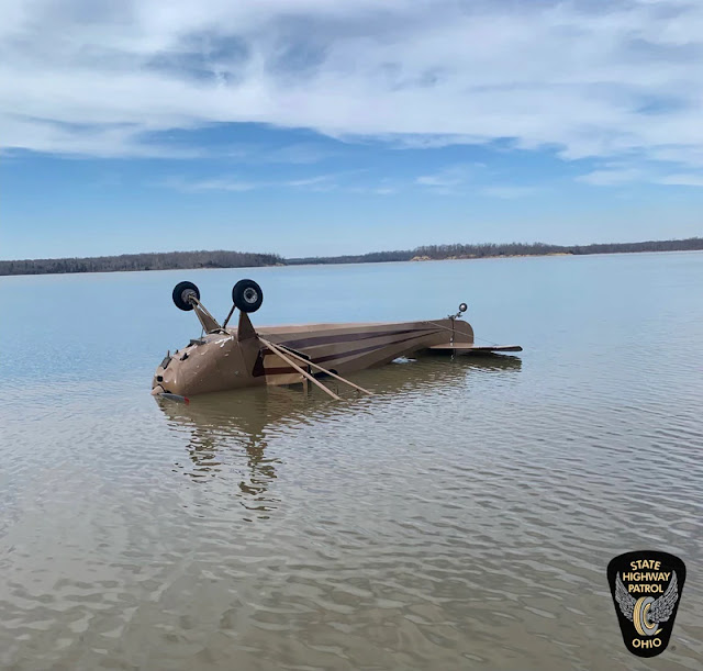
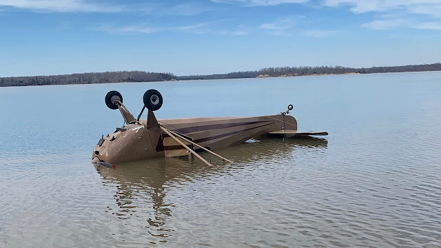
Investigators with Ohio State Highway Patrol said the engine of a small aircraft failed as it crossed Caesar Creek Lake. The pilot tried to set it down as close as it could to the bank. Though it flipped over on the water, both people inside were able to get out safely.

"I would have to give great thanks to my instructors, my support and my mentors along the path," pilot Ryan Pennington said. "As an instructor myself, I try to provide a good example to my students — always make good decisions, make quick decisions when things are going right and when things don't go as expected."

Ohio State Highway Patrol is investigating the crash.


WAYNESVILLE, Ohio (WKRC) - Ohio State Highway Patrol is investigating after a small plane crashed into a local lake Wednesday.

The incident happened at Caesar Creek. The 1946 plane was carrying a flight  instructor and student pilot  when the engine failed.

The plane landed in the water about 40 feet offshore.

Both the student and instructor made it out of the plane safely and were not injured.

Ohio State Highway Patrol is looking into what caused the plane to crash and working to recover the plane from the water.

Pilot Ryan Pennington told Local 12 he has only had the plane for a few months and now he fears it’ll never fly again.


HARVEYSBURG, Warren County — State troopers are investigating a plane crash near Caesar Creek State Park off Harveysburg Road Wednesday afternoon.

The crash was reported just before 4 p.m. and involves a single-engine plane, according to the Ohio State Highway Patrol. Troopers shared a photo of the plane, which shows it upside down in the lake

Troopers said there were two people onboard and there were no injuries.

The airplane involved in the crash is a 1946 Aeronca 11AC fixed-wing single-engine plane, according to FAA records.

The pilot of the plane told News Center 7 on scene that engine failure led to the crash.


WARREN COUNTY, Ohio (WXIX) - Two men are okay after a plane crashed into Caesar Creek Lake in Warren County, according to the Ohio State High Patrol Lebanon Post.

The plane went down around 4 p.m. Wednesday, OSHP said.

OSHP said the plane crashed in the lake just north of SR-73.


Cessna A185F Skywagon, N321JP: Incident occurred March 15, 2022 at Wrangell Airport (PAWG), Alaska

Federal Aviation Administration / Flight Standards District Office; Juneau, Alaska

Aircraft landed gear up on pontoons. 

Azure Skyes Holding LLC


Date: 15-MAR-22
Time: 17:48:00Z
Regis#: N321JP
Aircraft Make: CESSNA
Aircraft Model: A185
Event Type: INCIDENT
Highest Injury: NONE
Aircraft Missing: No
Damage: UNKNOWN
Activity: PERSONAL
Flight Phase: LANDING (LDG)
Operation: 91
City: WRANGELL
State: ALASKA

Cessna 172S Skyhawk SP, N653ND: Accident occurred March 06, 2022 and Incident occurred April 08, 2019

This is preliminary information, subject to change, and may contain errors. Any errors in this report will be corrected when the final report has been completed. 

The National Transportation Safety Board did not travel to the scene of this accident. 

Additional Participating Entity: 
Federal Aviation Administration / Flight Standards District Office; San Jose, California

UND Aerospace Foundation


Location: San Carlos, California 
Accident Number: WPR22LA123
Date and Time: March 6, 2022, 16:15 Local
Registration: N653ND
Aircraft: Cessna 172S 
Injuries: 1 None
Flight Conducted Under: Part 91: General aviation - Instructional

Aircraft and Owner/Operator Information

Aircraft Make: Cessna
Registration: N653ND
Model/Series: 172S
Aircraft Category: Airplane
Amateur Built:
Operator: 
Operating Certificate(s) Held: Pilot school (141)
Operator Designator Code:

Meteorological Information and Flight Plan

Conditions at Accident Site:
Condition of Light:
Observation Facility, Elevation: 
Observation Time:
Distance from Accident Site: 
Temperature/Dew Point:
Lowest Cloud Condition: 
Wind Speed/Gusts, Direction: / ,
Lowest Ceiling:
Visibility:
Altimeter Setting:
Type of Flight Plan Filed:
Departure Point:
Destination:

Wreckage and Impact Information

Crew Injuries: 1 None 
Aircraft Damage: Substantial
Passenger Injuries: N/A 
Aircraft Fire: None
Ground Injuries: 
Aircraft Explosion: None
Total Injuries: 1 None
Latitude, Longitude: 37.3071,-122.1497 

Federal Aviation Administration / Flight Standards District Office; Scottsdale, Arizona

April 08, 2019: Veered off runway at Phoenix-Mesa Gateway Airport (KIWA), Maricopa County, Arizona.

UND Aerospace Foundation

https://registry.faa.gov/N653ND

Date: 08-APR-19
Time: 23:10:00Z
Regis#: N653ND
Aircraft Make: CESSNA
Aircraft Model: 172S
Event Type: INCIDENT
Highest Injury: NONE
Aircraft Missing: No
Damage: MINOR
Activity: INSTRUCTION
Flight Phase: LANDING (LDG)
Operation: 91
City: PHOENIX
State: ARIZONA

Cessna 182K Skylane, N3136Q: Incidents occurred September 03, 2022 and March 15, 2022

Federal Aviation Administration / Flight Standards District Office; Las Vegas, Nevada

September 03, 2022: Aircraft made an emergency landing on a highway in Searchlight, Clark County, Nevada.

https://registry.faa.gov/N3136Q 

Date: 03-SEP-22
Time: 03:29:00Z
Regis#: N3136Q
Aircraft Make: CESSNA
Aircraft Model: 182
Event Type: INCIDENT
Highest Injury: NONE
Flight Crew: 1 No Injuries
Pax: 0
Aircraft Missing: No
Damage: UNKNOWN
Activity: PERSONAL
Flight Phase: EN ROUTE (ENR)
Operation: 91
City: SEARCHLIGHT
State: NEVADA

Federal Aviation Administration / Flight Standards District Office; Las Vegas, Nevada

March 15, 2022:  Aircraft landed and veered off runway striking a taxiway sign at Boulder City Municipal Airport (KBVU), Clark County, Nevada.


Date: 15-MAR-22
Time: 20:55:00Z
Regis#: N3136Q
Aircraft Make: CESSNA
Aircraft Model: 182
Event Type: INCIDENT
Highest Injury: NONE
Aircraft Missing: No
Damage: UNKNOWN
Activity: PERSONAL
Flight Phase: LANDING (LDG)
Operation: 91
City: BOULDER CITY
State: NEVADA

Embraer ERJ-175LR, N450YX: Incident occurred March 15, 2022 at Rhode Island T.F. Green International Airport (KPVD), Warwick, Kent County, Rhode Island

Federal Aviation Administration / Flight Standards District Office; Boston, Massachusetts

Aircraft struck a bird during departure damaging #2 engine cowling and blades. 

Republic Airways Inc


Date: 15-MAR-22
Time: 15:55:00Z
Regis#: N450YX
Aircraft Make: YABORA
Aircraft Model: ERJ170
Event Type: INCIDENT
Highest Injury: NONE
Aircraft Missing: No
Damage: UNKNOWN
Activity: COMMERCIAL
Flight Phase: TAKEOFF (TOF)
Operation: 121
Aircraft Operator: REPUBLIC AIRWAYS
Flight Number: RPA4639
City: PROVIDENCE
State: RHODE ISLAND