Wednesday, August 10, 2022

Cirrus SR22 G2, N379DH: Fatal accident occurred August 10, 2022 in Blyn, Washington

David Hodges


This is preliminary information, subject to change, and may contain errors. Any errors in this report will be corrected when the final report has been completed.

Investigator In Charge (IIC): Cawthra, Joshua

The National Transportation Safety Board traveled to the scene of this accident.

Additional Participating Entities:
Federal Aviation Administration / Flight Standards District Office; Seattle, Washington 
Justin Hanson; Federal Aviation Administration; Des Moines, Iowa
Cirrus Aircraft; Duluth, Minnesota 


Location: Blyn, Washington
Accident Number: WPR22FA298
Date and Time: August 10, 2022, 14:59 Local 
Registration: N379DH
Aircraft: CIRRUS DESIGN CORP SR22
Injuries: 1 Fatal
Flight Conducted Under: Part 91: General aviation - Personal

On August 10, 2022, about 1459 Pacific daylight time, a Cirrus SR22, N379DH, was substantially damaged when it was involved in an accident near Blyn, Washington. The pilot was fatally injured. The airplane was operated as a Title 14 Code of Federal Regulations Part 91 personal flight.

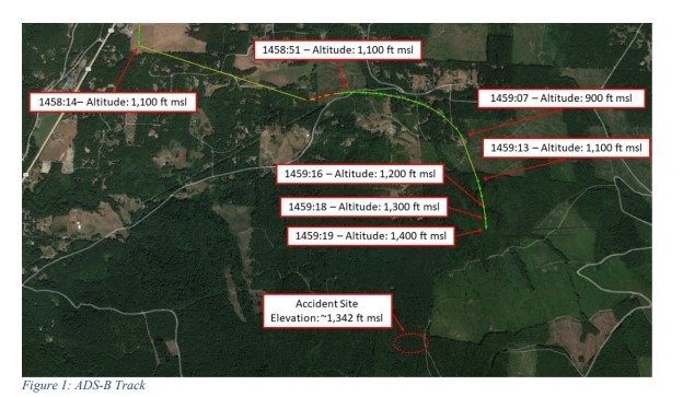
Recorded Automatic Dependent Surveillance Broadcast (ADS-B) data showed the airplane departed Friday Harbor Airport, Friday Harbor, Washington, about 1445, and proceeded on a southerly heading as it ascended to an altitude of about 1,100 ft mean sea level (msl). The airplane continued south until about 1458:14, when a loss of ADS-B coverage occurred. At 1458:51, ADS-B contact was reestablished,
and the data showed the airplane on an easterly heading. About 1 second later, a right turn to a southerly heading along with a descent to 900 ft msl. At 1459:07, a second loss of ADS-B coverage occurred, and was reestablished about 6 seconds later. The data showed the airplane on a southerly heading, at an altitude of 1,100 ft msl. The last ADS-B target was at 1459:19, at an altitude of 1,400 ft msl, located about 0.63 miles northeast of the accident site.

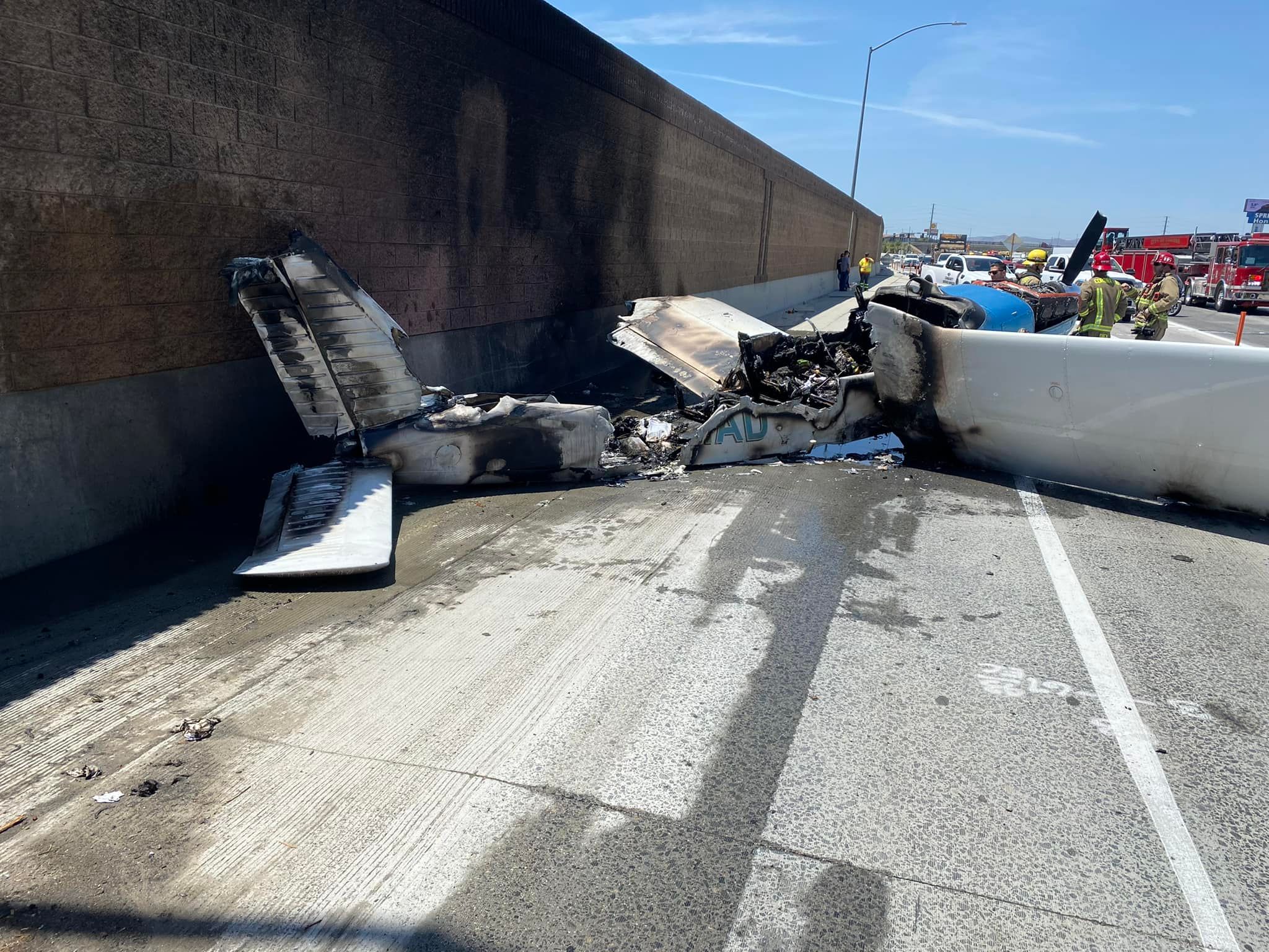
Examination of the accident site revealed that the airplane impacted a heavily wooded area. The first identified point of contact was a freshly topped tree, with composite material fragments located near the tree root. The debris path initially extended along an approximate 270° heading, for about 300 ft, before shifting to an approximate 312° heading, which extended for about 155 ft. The fuselage came to rest inverted on a heading of about 301°. All major structural components of the airplane were located within the debris path. The wreckage was recovered to a secure location for further examination.


Aircraft and Owner/Operator Information

Aircraft Make: CIRRUS DESIGN CORP
Registration: N379DH
Model/Series: SR22 
Aircraft Category: Airplane
Amateur Built:
Operator: On file 
Operating Certificate(s) Held: None
Operator Designator Code:

Meteorological Information and Flight Plan

Conditions at Accident Site: VMC 
Condition of Light: Day
Observation Facility, Elevation: KCLM, 273 ft msl
Observation Time: 14:53 Local
Distance from Accident Site: 23 Nautical Miles 
Temperature/Dew Point: 19°C /14°C
Lowest Cloud Condition:
Wind Speed/Gusts, Direction: 8 knots / , 260°
Lowest Ceiling: Overcast / 1300 ft AGL
Visibility: 10 miles
Altimeter Setting: 30.06 inches Hg
Type of Flight Plan Filed: None
Departure Point: Friday Harbor, WA (FHR)
Destination: Olympia, WA (OLM)

Wreckage and Impact Information

Crew Injuries: 1 Fatal
Aircraft Damage: Substantial
Passenger Injuries: 
Aircraft Fire: None
Ground Injuries: 
Aircraft Explosion: None
Total Injuries: 1 Fatal 
Latitude, Longitude: 48.025685,-122.94394

Aircraft crashed under unknown circumstances. 

Date: 10-AUG-22
Time: 22:10:00Z
Regis#: N379DH
Aircraft Make: CIRRUS
Aircraft Model: SR22
Event Type: ACCIDENT
Highest Injury: FATAL
Total Fatal: 1
Flight Crew: 1 Fatal
Pax: 0
Aircraft Missing: No
Damage: UNKNOWN
Activity: PERSONAL
Flight Phase: UNKNOWN (UNK)
Operation: 91
City: BLYN
State: WASHINGTON

Those who may have information that might be relevant to the National Transportation Safety Board (NTSB) investigation may contact them by email witness@ntsb.gov, and any friends and family who want to contact investigators about the accident should email assistance@ntsb.gov. You can also call the NTSB Response Operations Center at 844-373-9922 or 202-314-6290.


David Hodges
1956 - 2022


In loving memory of David William Hodges, who passed unexpectedly on August 10th, 2022. In the name of the many who loved him, we mourn his loss and cherish his memory. Survived by his wife Nancy Marlett-Hodges, mother Mildred Hodges, his five children, and four grandchildren. Beloved by the community he built in both Santa Rosa and Friday Harbor, David was a songwriter, performer, businessman, hunting and fishing enthusiast, but above all an amazing family man. If he touched your life in the way he did ours, take a moment to remember the joy and generosity David was known for. Whether it be a joke, a gift from the sea, a shared adventure or story, please keep him in your thoughts and in your hearts. A memorial will be held at 1pm on October 1st, 2022 at the Santa Rosa Christian Church, located at 1315 Pacific Ave, Santa Rosa, CA 95404.


The pilot who perished in a plane crash Wednesday west of Discovery Bay has been identified as David William Hodges, 66, of Friday Harbor.

"At this point there is no confirmed cause for the crash," Detective Brett Anglin  of the Jefferson County Sheriff's Office said Thursday in an email to The Leader.

The aircraft went down on Washington State Department of Natural Resources land

in the area between Diamond Point Road and the Maynard Peak radio site.

Hodges was believed to have been flying from Friday Harbor to Olympia.

"It is suspected at this point in time that fog may have been the cause, or contributed to the crash," Anglin added. "There was a significant fog bank in the area at the time, limiting visibility for our rescue crews."

Officials from the National Transportation Safety Board and the Federal Aviation Administration were at the crash site Thursday conducting an investigation.

The aircraft was identified as a Cirrus SR22, a single-engine four- or five-seat composite aircraft built by Cirrus Aircraft of Duluth, Minnesota.

"These incidents are always tragic event for the family involved, the first responders, and the neighbors who witnessed the event," Anglin added. "The quick actions by the community to report their observations proved vital in narrowing down the location of this scene."

Authorities earlier said a witness near the suspected crash site gave an excellent description of where they thought the plane had gone down, with the presumed crash location about a mile away in thick-forested land.

The Clallam County Fire District and Clallam County Sheriff’s Office initially responded to the report in the Blyn/Gardiner area.

The response included a fire engine and aid car from the Diamond Point station, an engine with medic from the Blyn station, and a rescue truck and medic unit from the Sequim station.

The Clallam County Sheriff’s Office search-and-rescue team, as well as a search-and-rescue helicopter from Naval Air Station Whidbey Island, were also requested.

Deputies from the Jefferson County Sheriff's Office arrived on scene quickly and added two unmanned aerial vehicles, better known as drones, to the search. Meanwhile, both the Clallam and Jefferson County search-and-rescue teams staged and prepared to look for the downed aircraft.

It was determined the crash site was likely in Jefferson County, so a unified command was established with Jefferson County Sheriff's Office and the fire district.

Shortly thereafter the search-and-rescue helicopter arrived and took over the aerial search.

Fog in the area hampered the view, but when a break in weather occurred, the helicopter was able to locate the crash site between Diamond Point Road and the Maynard Peak radio site and lower crews down.

A single victim was found, and the body was recovered and flown from the site.

Crews then entered the crash site on foot to conduct a search to confirm that there were no additional victims.

"As the responding duty chief, I was very impressed with the level of assistance, co-operation, coordination and expertise shown by all of the responders,” Andrews said.

”Several community members with local knowledge were also a great help in locating and accessing the crash site as quickly as we did. The effectiveness of this operation was due to everyone truly working together towards a common objective,” he added.

Loss of Control in Flight: Socata TBM700N (TBM850), N965DM; fatal accident occurred October 02, 2020 in Curfu, Genesee County, New York

Attorney Elizabeth Barnes


Aviation Accident Final Report - National Transportation Safety Board


Investigator In Charge (IIC): Kemner, Heidi

Additional Participating Entities:
Federal Aviation Administration / Flight Standards District Office; Buffalo, New York
Daher Aircraft; Paris
Hartzell; Piqua, Ohio
Bureau d'Enquetes et d'Analyses; Le Bourget
Transportation Safety Board of Canada
Pratt & Whitney Canada; Bridgeport, West Virginia

Investigation Docket - National Transportation Safety Board:

N965DM LLC


Location: Corfu, New York
Accident Number: ERA21LA003
Date and Time: October 2, 2020, 11:44 Local
Registration: N965DM
Aircraft: Socata TBM700 
Aircraft Damage: Destroyed
Defining Event: Loss of control in flight
Injuries: 2 Fatal
Flight Conducted Under: Part 91: General aviation - Personal

Analysis

The airplane was in cruise flight at FL280 when the instrument-rated pilot failed to contact air traffic control (ATC) following a frequency change assignment. After about 25 minutes, and when 30 miles east of the destination airport, the pilot contacted ATC on a frequency other than the one that was assigned. He requested the instrument landing system (ILS) approach at his intended destination, and the controller instructed the pilot to descend to 8,000 ft and to expect vectors for the ILS approach at the destination airport. The controller asked the pilot if everything was “okay,” to which the pilot replied, “yes sir, everything is fine.” The controller
then observed the airplane initiate a descent. About 2 minutes later, the controller asked the pilot where he was headed, and the pilot provided a garbled response. The controller instructed the pilot to stop his descent at 10,000 ft, followed by an instruction to stop the descent at any altitude. The pilot did not respond, and additional attempts to contact the pilot were unsuccessful. The airplane impacted terrain in a heavily wooded area 17 miles from the destination airport.

All major components of the airplane were located in the vicinity of the main wreckage. Examination of the airframe and engine revealed no preimpact mechanical malfunctions or failures with the airplane that would have precluded normal operation.

The investigation was unable to determine why the pilot was not in contact with ATC for 25 minutes. The pilot’s eventual contact with ATC about 30 miles from his intended destination, while still operating at his cruise altitude, suggests a clear breakdown in awareness of his position through distraction or impairment. However, upon re-establishing contact with ATC, the pilot’s communications were clear, nominal, and timely, which did not suggest impairment or use of an oxygen mask. Additionally, in response to a direct query from ATC the pilot did not indicate any difficulty. Further, there was no sign of airframe depressurization and examination of the wreckage did not reveal deployment of the passenger oxygen masks. Toxicology results were positive for ethanol at a low level, which was likely due to post-mortem production. 

Meteorological data and a performance study indicated that the pilot initiated a descent through multiple cloud layers about 15 seconds after acknowledging the descent clearance. During the initial portion of the airplane’s descent, its airspeed and rate of descent appeared to be nominal. About 2 minutes later, excessive airspeeds, descent rates, bank angles, and pitch attitudes were achieved. The performance study depicted the airplane entering a spiral dive during which the airplane exceeded airspeed, maneuvering, structural, and autopilot limitations. At 6,000 ft above ground level, and about 10 seconds before ground contact, the airplane descended through a final cloud layer, the descent profile shallowed, and the rate of descent decreased to 6,800 ft/min before radar data ended.

In addition, there were no clearances issued by ATC that would have required the pilot to change either the airplane’s rate of descent or track about this time; however, the airplane’s proximity to the destination airport may have created a heightened sense of urgency for the pilot to descend and or configure his avionics for the approach, which may have served as an operational distraction. Although it was possible that restrictions to visibility during the descent may have affected the pilot’s ability to maintain positive airplane control, there is insufficient information to determine how or why the pilot lost control.

Probable Cause and Findings

The National Transportation Safety Board determines the probable cause(s) of this accident to be:
The pilot’s failure to maintain control of the airplane for undetermined reasons during the descent to the destination airport.
Findings

Personnel issues Aircraft control - Pilot

Factual Information

History of Flight

Enroute-descent Loss of control in flight (Defining event)

On October 2, 2020, at 1144 eastern daylight time, a Socata TBM 700, N965DM, was destroyed when it was involved in an accident near Corfu, New York. The private pilot and passenger were fatally injured. The airplane was operated as a Title 14 Code of Federal Regulations Part 91 personal flight.

The airplane was serviced with 173 gallons of Jet A fuel on the morning of the accident, which filled the tanks. The first flight departed Buffalo Niagara International Airport (BUF), Buffalo, New York, at 0747 and landed at Manchester Airport (MHT), Manchester, New Hampshire, at 0914, where the passenger was boarded. No services were received before the airplane departed on the accident flight.

Radar data provided by the Federal Aviation Administration (FAA) depicted its departure at 1019, and a climb to flight level (FL) 280 where it remained in level flight. Air traffic control (ATC) voice communication data revealed the pilot checked in with the Boston Air Route Traffic Control Center following a frequency change issued by a previous controller, and about 25 minutes elapsed before the pilot established communication with Buffalo Approach Control when he was about 30 miles east of BUF.

On the initial contact, the pilot told the radar controller he had lost communication with center and was level at FL280. About 1141, the controller instructed him to descend to 8,000 ft and to expect the instrument landing system (ILS) runway 23 approach; radar data show the airplane began its descent about this time. A few seconds later, the controller asked the pilot if “everything was okay...” and the pilot responded, “yes sir, everything’s fine.” The controller then cleared the pilot to fly direct to BUF and to expect vectors for a left downwind to the runway 23 ILS. The pilot acknowledged this clearance.

About 2 minutes later, the controller asked the pilot where he was headed, and the pilot provided a “garbled” response. The controller then instructed the pilot to stop his descent and to maintain 10,000 ft, followed by an instruction to stop his descent and to maintain any altitude. The pilot did not respond, and several additional attempts to contact the pilot were unsuccessful.

Witnesses in the area surrounding the crash site reported that the engine sound was “very loud” before the sound of impact was heard.

Pilot Information

Certificate: Private 
Age: 62, Male
Airplane Rating(s): Single-engine land
Seat Occupied: Left
Other Aircraft Rating(s): None
Restraint Used: 4-point
Instrument Rating(s): Airplane 
Second Pilot Present: No
Instructor Rating(s): None
Toxicology Performed: Yes
Medical Certification: Class 3 Without waivers/limitations
Last FAA Medical Exam: May 29, 2020
Occupational Pilot: No 
Last Flight Review or Equivalent: March 30, 2019
Flight Time: (Estimated) 960 hours (Total, all aircraft), 239.2 hours (Total, this make and model)

The pilot reported having flown 60 hours during the 6 months before his last FAA medical examination. The pilot’s logbook reflected a flight on May 20, 2019, and completion of a SimCom recurrent course for the TBM850 on February 9, 2020. A summary of the logbook review revealed the pilot’s hours of flight experience during the 4 years prior to the accident.

Aircraft and Owner/Operator Information

Aircraft Make: Socata
Registration: N965DM
Model/Series: TBM700
Aircraft Category: Airplane
Year of Manufacture: 2009 
Amateur Built:
Airworthiness Certificate: Normal 
Serial Number: 527
Landing Gear Type: Retractable - Tricycle 
Seats: 6
Date/Type of Last Inspection: December 6, 2019 Annual 
Certified Max Gross Wt.:
Time Since Last Inspection:
Engines: 1
Airframe Total Time: 1181.8 Hrs as of last inspection
Engine Manufacturer:
ELT: Installed
Engine Model/Series:
Registered Owner: 
Rated Power:
Operator: On file 
Operating Certificate(s) Held: None

According to FAA records, the pilot purchased the airplane in June 2016. It was powered by a Pratt & Whitney Canada PT6A-66D, 850-horsepower engine equipped with a Hartzell constant-speed propeller.

According to the airplane flight manual, the airplane was equipped with an altimetric valve that provided an automatic passenger mask actuation function at a cabin altitude between 13,000 ft and 14,000 ft when the oxygen switch was set to ON.

Meteorological Information and Flight Plan

Conditions at Accident Site: Visual (VMC)
Condition of Light: Day
Observation Facility, Elevation: BUF, 716 ft msl
Distance from Accident Site: 16 Nautical Miles
Observation Time: 11:54 Local
Direction from Accident Site: 265°
Lowest Cloud Condition: Few / 2000 ft AGL 
Visibility 10 miles
Lowest Ceiling: Broken / 6000 ft AGL 
Visibility (RVR):
Wind Speed/Gusts: 9 knots /
Turbulence Type Forecast/Actual:  /
Wind Direction: 250° 
Turbulence Severity Forecast/Actual:  /
Altimeter Setting: 29.97 inches Hg 
Temperature/Dew Point: 13°C / 8°C
Precipitation and Obscuration: No Obscuration; No Precipitation
Departure Point: Manchester, NH (MHT) 
Type of Flight Plan Filed: IFR
Destination: Buffalo, NY (BUF)
Type of Clearance: IFR
Departure Time: 10:18 Local 
Type of Airspace:

The 1154 recorded weather observation at BUF, located about 17 miles west of the accident location, included wind from 250° at 9 knots, visibility 10 miles, few clouds at 2,000 ft above ground level (agl) and 3,500 ft agl, broken cloud layers at 6,000 ft agl and 14,000 ft agl, temperature 13°C, dew point 8°C, and an altimeter setting of 29.97 inches of mercury.

According to high-resolution rapid refresh model sounding for the accident site around 1200, the wind at FL190 was from the west about 25 knots. Relative humidity about FL190 was 33% and the relative humidity was above 90% for the entire atmosphere above about 9,000 ft. The freezing level was identified as about 5,200 ft. Calculations made by the Rawinsonde Observation Program (RAOB) did not identify any potential for icing, clouds, or significant turbulence between about 9,000 and 27,000 ft.

Wreckage and Impact Information

Crew Injuries: 1 Fatal
Aircraft Damage: Destroyed
Passenger Injuries: 1 Fatal 
Aircraft Fire: On-ground
Ground Injuries: N/A
Aircraft Explosion: None
Total Injuries: 2 Fatal 
Latitude, Longitude: 42.971879,-78.382376

The airplane impacted a heavily wooded, swampy area. The airplane was fragmented and damaged by post-crash fire. Wreckage and components of the airplane were buried 15 ft below the surface. All of the major components were accounted for at the scene. An odor of Jet A aviation fuel was noted at the accident site by first responders.

The fuselage was fragmented by impact forces. The door locking pins on the main cabin door were extended and the door handle was in the closed position. A passenger emergency oxygen mask was located separated from the airframe, but the mask remained inside its housing. Control cable continuity could not be confirmed due to the fragmentation of the fuselage. All sections of the cables and push-pull tubes located exhibited tensile overload fractures. The autopilot aileron and trip servos were located, and all cables exhibited tensile overload failures. A majority of each primary and secondary flight control surfaces were in the fragmented wreckage.

Both the forward and aft sections of the center wing spar were bent symmetrically about 43° aft from their original positions. The left elevator trim tab was separated from the left elevator and located in four sections. The inboard section of the right elevator trim remained attached to the elevator. The elevator trim actuators were located and measured 16mm, consistent with a neutral position. The rudder was impact separated from the vertical stabilizer. The top section of the rudder and rudder trim tab were not located. The tail-cone was impact separated and located in the wreckage.

Examination of the engine revealed that the accessory gearbox and inlet case were impact separated, and they were not located. Multiple parts of the power turbine section and compressor section of the engine exhibited rotational scoring. Multiple blades were fractured, smeared, and bent the opposite direction of travel. The fracture surfaces that were not smeared exhibited features consistent with overload.

The propeller hub was impact-separated from the engine. All five blades were impact separated from the hub. A portion of each of the five blades was found in the wreckage.

Additional Information

Performance Study

A performance study was conducted using airplane weight, radar, communications, and weather data. The results indicated the airplane was in cruise flight at 28,000 ft and about 190 knots calibrated airspeed (KCAS) until 1141:17, when over a 30-second span, the nose pitched down about 10° and the rate of descent increased to 4,500 ft/minute. The descent was initiated 15 seconds after the airplane was cleared to descend from its cruising altitude. The airplane maintained its assigned heading until 1143:31. At that time, the airplane descended through 19,300 ft and accelerated through its maximum operating speed of 271 KCAS.

The study showed that the airplane then entered a right banking turn that reached nearly 90°, with a pitch-down attitude of 47°. Both airspeed and rate of descent increased in the descending turn. Airspeed reached 350 KCAS and the rate of descent peaked at 28,400 ft/min at 1144:13, and then decreased to 6,800 ft/min at the end of the data. The computed normal load factor increased to about 3.8 G during the descent. The study noted the descent profile was consistent with a spiral dive.

Limitations

According to the manufacturer, the airplane autopilot engagement limitation for angle of bank was +/-45° and -15° for descending pitch angle. In addition, the autopilot operational envelope (commands limit) was +/- 25° for bank angle and -10° for descending pitch angle. Furthermore, the airplane was equipped with an emergency descent mode that, when engaged, would signal the autopilot to initiate a 90° left turn and descent up to 4,000 ft/min (depending on airplane loading, power lever positions, and weather conditions) until the airplane reached the target altitude of 15,000 ft msl.

Medical and Pathological Information

According to the autopsy report from the Office of the Medical Examiner, Monroe County, New York, the cause of the pilot’s death was multiple blunt force injuries, and the manner of death was accident. The examination was limited by the extensive injuries.

Toxicology testing performed by the FAA Forensic Sciences Laboratory detected ethanol in the pilot’s muscle tissue at 0.022 grams per hectogram (gm/hg). No other tested for drugs were detected in his muscle tissue. Toxicology testing performed for the medical examiner’s office was negative for ethanol and tested for drugs in the pilot’s muscle tissue.

Ethanol is a social drug commonly consumed by drinking beer, wine, or liquor. It acts as a central nervous system depressant; it impairs judgment, psychomotor functioning, and vigilance. Ethanol is water soluble, and after absorption it quickly and uniformly distributes throughout the body’s tissues and fluids. The distribution pattern parallels water content and blood supply of the tissue. Ethanol can be produced after death by microbial activity; sometimes in conjunction with other alcohols, such as propanol. Extensive trauma increases the spread of bacteria and raises the risk of ethanol production after death.

Sonex Waiex, N51YX: Fatal accident occurred August 09, 2022 in Maxwell, Colusa County, California

This is preliminary information, subject to change, and may contain errors. Any errors in this report will be corrected when the final report has been completed.

Aviation Accident Preliminary Report - National Transportation Safety Board

Investigator In Charge (IIC): Hodges, Michael

The National Transportation Safety Board traveled to the scene of this accident.

Additional Participating Entity:
Federal Aviation Administration / Flight Standards District Office; Sacramento, California 


Location: Maxwell, California
Accident Number: CEN22FA375
Date and Time: August 9, 2022, 11:06 Local 
Registration: N51YX
Aircraft: Sonex Aircraft Waiex 
Injuries: 1 Fatal
Flight Conducted Under: Part 91: General aviation - Personal

On August 9, 2022, about 1106 pacific daylight time, a Sonex Aircraft Waiex airplane, N51YX, was destroyed when it was involved in an accident near Maxwell, California. The pilot sustained fatal injuries. The airplane was operated as a Title 14 Code of Federal Regulations Part 91 personal flight.

A preliminary review of Automatic Dependent Surveillance – Broadcast (ADS-B) data showed that the airplane departed runway 13 at the Colusa County Airport (O08), Colusa, California, about 1027. The airplane traveled to the north of Colusa and then traveled to the west. After the airplane crossed the I-5 highway, the airplane traveled to the north of Maxwell, California, where the ADS-B data terminated in a remote area populated with fields used for agricultural work.

The airplane came to rest nose down, in a flat dirt field. The wreckage sustained fire damage.

The wreckage was recovered from the accident site for a future examination.

The estimated density altitude for the accident site was 1,449 ft above msl.

Aircraft and Owner/Operator Information

Aircraft Make: Sonex Aircraft 
Registration: N51YX
Model/Series: Waiex 
Aircraft Category: Airplane
Amateur Built: Yes
Operator: On file 
Operating Certificate(s) Held: None
Operator Designator Code: None
  
Meteorological Information and Flight Plan

Conditions at Accident Site: VMC 
Condition of Light: Day
Observation Facility, Elevation: KOVE,187 ft msl 
Observation Time: 10:53 Local
Distance from Accident Site: 29 Nautical Miles
Temperature/Dew Point: 25°C /14°C
Lowest Cloud Condition: Clear 
Wind Speed/Gusts, Direction: 8 knots / , 150°
Lowest Ceiling: None
Visibility: 10 miles
Altimeter Setting: 29.95 inches Hg 
Type of Flight Plan Filed: None
Departure Point: Colusa, CA (O08)
Destination: Maxwell, CA

Wreckage and Impact Information

Crew Injuries: 1 Fatal
Aircraft Damage: Destroyed
Passenger Injuries: N/A 
Aircraft Fire: On-ground
Ground Injuries: N/A 
Aircraft Explosion: Unknown
Total Injuries: 1 Fatal 
Latitude, Longitude: 39.378551,-122.22683 (est)

Those who may have information that might be relevant to the National Transportation Safety Board (NTSB) investigation may contact them by email witness@ntsb.gov, and any friends and family who want to contact investigators about the accident should email assistance@ntsb.gov. You can also call the NTSB Response Operations Center at 844-373-9922 or 202-314-6290. 


According to a press release issued Thursday, August 11, by the Colusa County Sheriff’s Office, the pilot who was killed in an aircraft crash on Tuesday has been identified as Jack Davis of Sacramento.

As reported yesterday in The Observer, at about 10:55 a.m. on Tuesday, August 9, Glenn County Sheriff’s deputies responded to the area of County Roads 71 and F for a report of a downed aircraft. The location of the crash was soon determined to be in Colusa County, just south of the Colusa-Glenn County line.

Besides the Glenn County Sheriff’s Office, the Colusa County Sheriff’s Office, the Willows Fire Department, the Maxwell Fire Department, and Enloe Ambulance also responded.

The Glenn County Sheriff’s log gave the tail number, or N-number, of the plane: N51YX. This number can guide one to numerous websites with useful information.

The aircraft was a 2007 Sonex Waiex, a fixed-wing single-engine plane. The builder (and, apparently, longtime owner) of this kit plane was Raymond A. Krause of Sacramento and Colusa.

Apparently since June 4, the plane was co-owned by Jack R. Davis of Sacramento and Clinton B. Jewett of Colusa. According to Thursday’s press release from the Colusa County Sheriff’s Office, the pilot who was killed was Jack Rodney Davis, 73.

The Federal Aviation Administration (FAA) and National Transportation Safety Board (NTSB) were notified and have taken over the investigation. The Colusa County Sheriff’s Office asks that anyone with information call Lt. Jose Ruiz at 530-458-0200.


Aircraft crashed under unknown circumstances and post crash fire. 

Date: 09-AUG-22
Time: 18:06:00Z
Regis#: N51YX
Aircraft Make: SONEX
Aircraft Model: WAIEX
Event Type: ACCIDENT
Highest Injury: FATAL
Total Fatal: 1
Flight Crew: 1 Fatal
Pax:  0
Aircraft Missing: No
Damage: DESTROYED
Activity: PERSONAL
Flight Phase: UNKNOWN (UNK)
Operation: 91
City: MAXWELL
State: CALIFORNIA

Those who may have information that might be relevant to the National Transportation Safety Board (NTSB) investigation may contact them by email witness@ntsb.gov, and any friends and family who want to contact investigators about the accident should email assistance@ntsb.gov. You can also call the NTSB Response Operations Center at 844-373-9922 or 202-314-6290. 


COLUSA COUNTY, California — One person is dead after a plane crash in Colusa County.

The Colusa County Sheriff's Office responded to a reported plane crash near McDermott Road and the Glenn-Colusa County line in Maxwell just after 11 a.m. 

Arriving first responders found the crash and confirmed that the pilot was dead at the scene.

The cause of death has not been determined at this time, and the investigation into the crash is ongoing. The Federal Aviation Administration and the National Transportation Safety Board are investigating the crash.

Anyone with information regarding the crash can call Lt. J. Ruiz at (530) 458-0200.

WILLOWS — The pilot of a small plane died in a crash Tuesday near McDermott Road by the Glenn and Colusa county line, according to a press release from the Colusa County Sheriff’s Office. 

The Willows Fire Department along with Glenn County Sheriff’s Office responded to the plane crash with fire around 11:06 a.m. 

The Colusa County Sheriff’s Office along with the Maxwell Fire Department were also dispatched. 

Fire crews put flames out while trying to preserve the crash site. 

Lt. Jose Ruiz of the Colusa County Sheriff’s Office said that the National Transportation Safety Board and the Federal Aviation Administration investigators would not be out until Wednesday and a deputy would be at the site overnight.

Cessna 182Q Skylane II, N727PC: Fatal accident occurred August 09, 2022 near Centennial Airport (KAPA), Denver, Colorado

This is preliminary information, subject to change, and may contain errors. Any errors in this report will be corrected when the final report has been completed.

Investigator In Charge (IIC): Gallo, Mitchell

The National Transportation Safety Board traveled to the scene of this accident.

Additional Participating Entities:
Scott Farron; Federal Aviation Administration / Flight Standards District Office; Denver, Colorado
Textron Aviation; Wichita, Kansas

PB&J Holding LLC


Location: Centennial, Colorado
Accident Number: CEN22FA376
Date and Time: August 9, 2022, 12:50 Local 
Registration: N727PC
Aircraft: Cessna 182Q
Injuries: 1 Fatal
Flight Conducted Under: Part 91: General aviation - Unknown

On August 9, 2022, at 1250 mountain daylight time, a Cessna 182Q, N727PC, was destroyed when it was in involved in an accident near Centennial, Colorado. The pilot was fatally injured. The airplane was operated as a Title 14 Code of Federal Regulations Part 91 flight.

The airplane owner stated that he did not know why the pilot was flying the airplane and that the pilot had been checked out in the airplane. A flight instructor, who had flown with the pilot for purposes of an airplane checkout, stated that the pilot had not completed an airplane checkout and that the planned checkout had a five-hour flight duration. The last entry in the pilot’s logbook was dated July 15, 2022, for a flight in the accident airplane that was 1.2 hours in duration, and it was the only logbook entry listing the accident airplane.

A witness stated that the airplane “did not sound right.” He said the airplane was “sputtering,” and about 150 – 200 ft above ground level, the airplane nose went down, the airplane rapidly lost altitude, and the airplane impacted the ground.

A post-accident examination of the airplane revealed a nose-low, low-speed impact with terrain, consistent with an aerodynamic stall. There was no fuel in either wing tank. The fuel system header tank contained about ½ pint of fuel. There was no fuel in the fuel lines leading to the engine. The examination confirmed flight control continuity.

The wreckage was retained for further examination.

Aircraft and Owner/Operator Information

Aircraft Make: Cessna
Registration: N727PC
Model/Series: 182Q
Aircraft Category: Airplane
Amateur Built:
Operator: On file
Operating Certificate(s) Held: None
Operator Designator Code:

Meteorological Information and Flight Plan

Conditions at Accident Site: VMC 
Condition of Light: Day
Observation Facility, Elevation: APA,5885 ft msl
Observation Time: 12:53 Local
Distance from Accident Site: 0.8 Nautical Miles
Temperature/Dew Point: 32°C /9°C
Lowest Cloud Condition: Few / 8000 ft AGL 
Wind Speed/Gusts, Direction: 9 knots / , 40°
Lowest Ceiling: None
Visibility: 10 miles
Altimeter Setting: 30.27 inches Hg
Type of Flight Plan Filed:
Departure Point: Centennial, CO
Destination:

Wreckage and Impact Information

Crew Injuries: 1 Fatal 
Aircraft Damage: Destroyed
Passenger Injuries:
Aircraft Fire: None
Ground Injuries: 
Aircraft Explosion: None
Total Injuries: 1 Fatal
Latitude, Longitude: 39.570119,-104.84929 (est)

Aircraft crashed under unknown circumstances after departure. 

Date: 09-AUG-22
Time: 18:50:00Z
Regis#: N727PC
Aircraft Make: CESSNA
Aircraft Model: 182
Event Type: ACCIDENT
Highest Injury: FATAL
Total Fatal: 1
Flight Crew: 1 Fatal
Pax: 0
Aircraft Missing: No
Damage: UNKNOWN
Activity: PERSONAL
Flight Phase: TAKEOFF (TOF)
Operation: 91
City: DENVER
State: COLORADO

Those who may have information that might be relevant to the National Transportation Safety Board (NTSB) investigation may contact them by email witness@ntsb.gov, and any friends and family who want to contact investigators about the accident should email assistance@ntsb.gov. You can also call the NTSB Response Operations Center at 844-373-9922 or 202-314-6290. 


Jim Shumway
~

James "Jim" William Shumway, 57, of Parker, Colorado, entered into heaven on August 9th, 2022 as a result of a single-engine plane crash at Centennial Airport, Douglas County.

Jim was born in Salt Lake City, UT on March 10th, 1965 to Ronald F. Shumway and Rosa L. Basham Shumway. He was the 2nd of 3 children.

Jim was raised in Hinkley, Millard County, UT. He graduated from Hinkley Elementary and Delta High School.

Jim learned how to work hard from a very young age. He raised animals and grew giant gardens on the family farm. But he learned how to truly labor work alongside his dad in his construction business.

Jim was called to serve a mission for the Church of Jesus Christ of Latter-Day Saints to the Alberta, Calgary MISSION, 1984-1986.

Jim finished his degree at Southern Utah University in Cedar City where he made lifelong friends. Jim's quiet and unassuming nature and fun sense of humor drew people to him.

Jim met Rebecca while working in Sedona in 1991. They were married in the St. George Temple on May 22, 1993.

While living in Las Vegas from 1993-2002, the Shumway family grew to include 4 children: Brittany, Alex, Ashley and Lilly. He received his MBA at UNLV.

In 2002 they moved to Parker, Colorado where they currently love living and had their fifth child, Maxwell.

Since 2005 Jim has loved working at ET investments, LLC with so many wonderful people.

Jim started flying in 2017 and got his pilots license in 2018 which quickly became a passion.

When he wasn't working or flying, he enjoyed fishing, hunting, building and grilling and of course, his family.

The world is a darker, less colorful place without Jim. He was a true gentleman. His kindness, compassion and generosity has touched more lives than he ever realized. His warm smile will continue in our hearts and memories but his presence leaves a gaping hole in our lives.

He is survived by his Wife of 29 years, Rebecca Shumway; Children: Brittany Belle, Alexander James, Ashley Rose, Lilly Elizabeth, and Maxwell William; Siblings: Sister: Georgia Shumway Crouch and spouse, Rob and children, Kevin, Dani, Bryan and Camille, Brother: Mark Shumway and spouse Nana and their children Eric, Ethan and Avery. Preceded in death by his parents: Ronald Franklin and Rosa Basham Shumway.

Graveside 3:00 pm at Franktown Cemetery.

Services: Visitation 10:30 am to 11:30 am with Funeral Service 11:30 am on Friday, August 19, 2022 at The Church of Jesus Christ of Latter-Day Saints, 7160 Bayou Gulch Rd in Parker CO. Graveside 3:00 pm at Franktown Cemetery, Franktown, CO.


DOUGLAS COUNTY, Colorado — A coroner has identified the pilot who died in a single-engine plane crash east of Centennial Airport on Tuesday afternoon.

The Douglas County Coroner’s Office identified the pilot as 57-year-old James Shumway, of Parker. Shumway was the only person in the plane.

An autopsy has been scheduled and the coroner will rule on the cause and manner of death after the investigation is complete.

On Tuesday afternoon, South Metro Fire Rescue (SMFR) and the Douglas County Sheriff's Office responded to the crash, which happened near a FedEx facility north of E-470 and west of the S. Chambers Road exit, after a person called 911 around 12:50 p.m., said Eric Hurst, public information officer with SMFR.

Hurst said the plane crashed a few seconds after takeoff from the Centennial Airport.

The National Transportation Safety Board will investigate the cause of the crash.

No buildings or passing people or vehicles were damaged.

Piper PA-32-300 Cherokee Six, N841AD: Accident occurred occurred August 09, 2022 near Corona Municipal Airport (KAJO), Riverside County, California

This is preliminary information, subject to change, and may contain errors. Any errors in this report will be corrected when the final report has been completed.

Aviation Accident Preliminary Report - National Transportation Safety Board

Investigator In Charge (IIC): Gutierrez, Eric

The National Transportation Safety Board did not travel to the scene of this accident.

Additional Participating Entity:
Federal Aviation Administration / Flight Standards District Office; Riverside, California

Cedar Real Estate Inc
Location: Corona, California 
Accident Number: WPR22LA296
Date and Time: August 9, 2022, 12:31 Local
Registration: N841AD
Aircraft: Piper PA-32-300 
Injuries: 2 None
Flight Conducted Under: Part 91: General aviation - Personal

On August 9, 2022, about 1231 Pacific daylight time, a Piper, PA-32-300, N841AD, was substantially damaged when it was involved in an accident near Corona, California. The pilot and passenger were not injured. The airplane was operated as a Title 14 Code of Federal Regulations Part 91 personal flight. The pilot reported that he adjusted the engine power to level off and reduce airspeed while entering the downwind leg of the traffic pattern for runway 25. He stated the engine did not respond and he cycled the throttle several times with no change. The airplane was unable to maintain altitude and the pilot elected to make a forced landing onto the eastbound lanes of US freeway 91. During the landing flare, to prevent the airplane from impacting a car, the pilot intentionally stalled the airplane. The airplane subsequently landed hard, rotated to the right (clockwise) and impacted freeway barrier. He and the passenger exited the airplane. A postaccident fire ensured.

The wreckage was recovered to a secure location for further examination.

Aircraft and Owner/Operator Information

Aircraft Make: Piper
Registration: N841AD
Model/Series: PA-32-300 
Aircraft Category: Airplane
Amateur Built:
Operator: 
Operating Certificate(s) Held: None
Operator Designator Code:

Meteorological Information and Flight Plan

Conditions at Accident Site: VMC 
Condition of Light: Day
Observation Facility, Elevation: KAJO,533 ft msl 
Observation Time: 12:56 Local
Distance from Accident Site: 0 Nautical Miles 
Temperature/Dew Point: 36°C /13°C
Lowest Cloud Condition: Clear
Wind Speed/Gusts, Direction: 10 knots / , 280°
Lowest Ceiling: None
Visibility: 10 miles
Altimeter Setting: 29.92 inches Hg
Type of Flight Plan Filed: None
Departure Point: Corona, CA 
Destination: Corona, CA

Wreckage and Impact Information

Crew Injuries: 1 None 
Aircraft Damage: Substantial
Passenger Injuries: 1 None
Aircraft Fire: On-ground
Ground Injuries:
Aircraft Explosion: None
Total Injuries: 2 None 
Latitude, Longitude: 33.897654,-117.60244 (est)

Aircraft experienced engine issues, made an emergency landing on a highway and post crash fire.  

Date: 09-AUG-22
Time: 19:31:00Z
Regis#: N841AD
Aircraft Make: PIPER
Aircraft Model: PA32
Event Type: ACCIDENT
Highest Injury: NONE
Aircraft Missing: No
Damage: SUBSTANTIAL
Activity: PERSONAL
Flight Phase: APPROACH (APR)
Operation: 91
City: CORONA
State: CALIFORNIA

“It was like a heavy blow. It’s hard to describe,” pilot Andrew Cho told KTLA. “We were four to five feet in the air when the plane came to a complete stop and fell to the ground.”


The pilot and passenger of a single-engine plane escaped unscathed after it crash-landed on a California freeway Tuesday afternoon.

Andrew Cho, who was flying a Piper PA-32-300 Cherokee Six, lost engine power and decided to use the 91 Freeway near Corona in Riverside County, east of Los Angeles, as an airstrip.

Dashcam footage captured the dramatic moment the plane managed to land between cars around 12.30 pm in the eastbound lanes.

The landing was nearly flawless until one of the wings caught a passing pickup truck, tearing off one of its wings and spinning the plane, spilling flammable fuel onto the road surface.

The plane caught fire as it traveled along the freeway lanes before coming to rest on the shoulder.

Seconds later, passing drivers captured the moment Cho and his business partner, a passenger, escaped from the burning wreckage as thick black smoke billowed into the air.

“It was like a heavy blow. It’s hard to describe,” Cho told KTLA. “We were four to five feet in the air when the plane came to a complete stop and fell to the ground.”

Cho said that it was all thanks to training that he was able to make an emergency landing.

“Your training kicks in and you’re doing the right things. As long as you don’t panic, you’ll get the best result,” he explained.

“The pilot states that he may have experienced engine failure on his final approach to the Corona Municipal Airport,” California Highway Patrol Capt. Levi Miller said.

“We were very fortunate today that the traffic was light and the pilot appears to have navigated the landing well, averting what could have been a very scary tragedy,” Miller added.

The driver and three passengers of the pickup truck, which was also hit by one of the plane’s wings, were also not injured.

Parts of the freeway were closed for several hours while the wreckage was cleared and Federal Aviation Administration investigators tried to determine the cause of the crash.


CORONA, Calif. (CNS) — A single-engine airplane experiencing engine trouble crash-landed on the Riverside (91) Freeway in Corona Tuesday, triggering a fire from which the plane's occupants narrowly escaped unharmed.

The forced landing involving the  Piper PA-32-300 Cherokee Six occurred at 12:30 p.m. on the eastbound 91 at Lincoln Avenue, according to the Federal Aviation Administration and the California Highway Patrol.

The aircraft was "flying to Corona Municipal Airport (when) ... the pilot reported an engine issue," according to an FAA statement.

The pilot was unable to make the turn north toward the airfield, possibly due to a rapid loss of altitude, and opted to make an emergency landing straight ahead on the freeway. The aircraft made contact with a Toyota Tundra pickup truck, causing unspecified minor damage, but did not injure the driver, officials said.

Images captured on motorists' dashcams, as well as Caltrans' freeway cameras, showed the plane coming down hard and clipping a retaining wall, igniting a fire on board, then bouncing to a stop, with the nose of the Cherokee pointing into lanes and the tail on the shoulder of the eastbound 91.

Corona Fire Department engine crews reached the location within five minutes and discovered the plane in flames. The pilot and passenger, neither of whom were identified, self-extricated themselves from the wrecked aircraft and did not require medical aid.

No motorists were injured.

Corona firefighters extinguished the blaze just before 1 p.m.

There was no word on the airport from which the aircraft departed. According to FAA records the tail number N841AD is owned by a company in Anaheim.

Eastbound 91 traffic came to a virtual standstill immediately after the crash. However, CHP officers only closed the No. 4 and 5 lanes, where the plane went down. The Lincoln Avenue on-ramp was also closed. Three lanes, plus the fast-track lane, remained open.

As of 5 p.m., the burned-out remains of the aircraft were still on the freeway, but the wreckage was expected to be cleared Tuesday night.

Honda HA-420 HondaJet, N227WP: Judge Orders Forfeiture of Michael Avenatti’s Jet, Purchased with Stolen Client Money and Seized in 2019


https://registry.faa.gov/N227WP


Case SACR 19-061-JVS


A federal judge today ordered the forfeiture of a jet Michael Avenatti bought with stolen client money.

The five-page order from Senior U.S. District Judge James V. Selna in the Central District of California provides 30 days for anyone other than Avenatti to request a hearing “to adjudicate the validity” of their claimed interest in the Honda HA-420 HondaJet, originally valued at $4.5 million.

There are at least a few possibilities of that occurring, as Alexis Gardner, the client whose settlement money Avenatti used to buy the jet, already has a claim for it pending in a separate U.S. District Court action.

The jet also was not fully Avenatti’s property: It was half owned by William Parrish, another Avenatti client, who was investing in business with him after Avenatti helped secure a $39 million settlement for him and his friend Timothy Fitzgibbons in a trade secrets lawsuit.

As acknowledged in his guilty pleas before Selna in June, Avenatti admitted to embezzling $2.5 million from Gardner’s settlement and transferring it to another law firm, which, as established in trial last year, was controlled by his former law partner Filippo Marchino.

Marchino then used the money to pay for Avenatti’s share of the jet. In a twist, Marchino is now representing Gardner in a crossclaim that says the jet’s value “is about the same as Gardner’s compensatory damages and Gardner should be awarded a 100% ownership interest in the Subject Aircraft.”

The crossclaim was filed in a federal lawsuit brought by Starr Indemnity & Liability Co., through which Parrish and Avenatti insured the jet, that says it never would have extended them policies if they’d known Avenatti had paid for part of the jet with stolen money.

Marchino could not immediately be reached for comment on Tuesday. He’s fighting his own Avenatti-related case in U.S. Bankruptcy Court, as the trustee for bankrupt Eagan Avenatti LLP is accusing him of conspiring to hide Avenatti’s assets by moving lucrative cases away from the firm.

Parrish’s lawyer Larry Conlan told Law&Crime today that Parrish may contest the forfeiture.

“We are analyzing the situation now,” Conlan said in an email.

Read Judge Selna’s full order:  https://lawandcrime.com

de Havilland Canada DHC-2 Beaver Mk 1, N1249K: Fatal accident August 05, 2021 in Ketchikan, Alaska

Families of 4 killed in Alaska floatplane crash sue Holland America, alleging cruise company pressures excursion operators

Pilot Rolf Lanzendorfer


The families of four tourists killed in an Alaskan floatplane crash last year have sued Holland America Line, alleging the Seattle-based cruise company pressures outside excursion operators to take unnecessary risks to meet cruise schedules and doesn’t warn passengers of excursion dangers.

The lawsuit, filed in U.S. District Court in Seattle, alleges Holland America knew of the dangers because passengers on previous trips had died in similar crashes. Rather than warning its passengers that such trips come with risks, the lawsuit accuses Holland America of merely requiring floatplane excursion operators — most of which are independent businesses — to add the cruise line company to their insurance policies.

“Under maritime law, the Holland Defendants had a duty to warn passengers of these risks,” the lawsuit says. “Thus, the Holland Defendants response … was to protect itself from liability rather than protect its cruise passengers — by mitigating associated risks or warning its passengers of the risks involved in floatplane excursions.”

The lawsuit was filed on behalf of the families of Andrea McArthur, 55, and her 20-year-old daughter, Rachel McArthur, both of Woodstock, Georgia; Jacquelyn Komplin, 60, of Napa, California; and Janet Kroll, 77, of Mount Prospect, Illinois.

The four were among six people killed when a floatplane owned by Southeast Aviation of Ketchikan, Alaska, slammed into a mountainside while touring Misty Fjords National Monument in bad weather Aug. 5, 2021.

All of the flight’s passengers had been aboard Holland America’s ship Nieuw Amsterdam, which was docked in Ketchikan as part of a seven-day “Alaska Explorer” cruise, according to the lawsuit.

Also killed were pilot Rolf Lanzendorfer, 64, of Cle Elum, Kittitas County, who’s named as a defendant, and Mark Henderson, 69, of Napa, whose family is not a party to the lawsuit.

The lawsuit alleges Lanzendorfer had only recently returned to work at Southeast Aviation after having been involved in another floatplane crash a month earlier. According to news reports, National Transportation and Safety Board regional chief Clint Johnson said Lanzendorfer was flying alone in a Southeast floatplane when he hit a buoy shortly after takeoff and flipped the plane.

The lawsuit claims that a Federal Aviation Administration investigation found Lanzendorfer acted “carelessly” when he failed to properly taxi and clear his takeoff in the July 9, 2021, crash.

The fatal August 5, 2021, crash came as Lanzendorfer was trying to return to Ketchikan to get his passengers to the Holland America ship before it departed at 4 p.m. According to weather reports cited in the lawsuit, the cloud ceiling was as low as 600 feet that day.

The lawsuit notes that Misty Fjords National Monument “takes its name for the near constant precipitation … which causes mist and low clouds that often cling to sheer cliffs rising from the fjords and obscure the mountaintops.”

The lawsuit alleges Lanzendorfer flew the floatplane “intentionally, carelessly, recklessly and with conscious disregard for the safety of the paying passengers … into unsafe weather conditions, which increased the probability that serious harm and fatalities would result.”

The lawsuit notes that the tourists who were killed purchased their excursions through a private travel agent or operator. However, the lawsuit claims Holland America promoted those excursions in its literature and on its website, stating that “only by air can you fully appreciate the dramatic beauty of land slowly crafted by nature over tens of thousands of years.”

“They use these exciting excursions to sell cruises,” said Atlanta attorney Ranse Partin, the lead plaintiff attorney.

James Rogers, a Seattle lawyer for the plaintiffs, said Holland America failed to warn its passengers “of the dangers posed by these flights, which they well know.”

The lawsuit alleges that Holland America knows its schedules “heavily influence the tour schedules of shore excursion operators.” And while Holland America doesn’t provide the excursions, the cruise line advertises and markets them to “promote the overall cruise experience,” the lawsuit says, noting that both the cruise line and third-party operators benefit from high numbers of cruise passengers booking excursions.

The lawsuit also states that the NTSB has expressed concerns about this relationship and the pressures it puts on excursion providers. The agency reported that seaplane and floatplane excursions in Alaska were involved in 207 crashes involving 80 fatalities between January 2008 and June 2019.

“The mountainous terrain coupled with hazardous weather conditions, high aviation traffic and tight sightseeing floatplane tour schedules due to a desire for operators and cruise lines to maximize the number of participating passengers for increased profits, created an unreasonably dangerous excursion,” the lawsuit claims.

The lawsuit references two other fatal floatplane crashes involving cruise passengers, including a June 2015 crash that killed eight passengers and the pilot on a similar excursion to view Misty Fjords National Monument. The NTSB in its final report “attributed that crash to scheduling pressures that force some seaplane operators to fly in marginal weather conditions.”

The agency asked the Cruise Lines International Association in a subsequent letter to investigate the dynamics of the relationship between cruise lines and excursion operators to try to mitigate some of those risks, the lawsuit claims.

A Holland America spokesperson, who declined to be named, said in a statement: “We were incredibly saddened by this tragedy and our hearts go out to the families of those who died.”

“This floatplane excursion was independently operated and purchased separately by the impacted guests and not sold through or advertised by Holland America Line,” the statement said. “Safety is of utmost importance to us, and our contracts with tour operators emphasize it as a top priority.”

An individual who identified himself as Jim Kosmos, answering a Monday phone call to the offices of Southeast Aviation, declined to provide his position with the company and said he had no comment on the lawsuit.

Records show Kosmos is the company’s owner.


Pilot Rolf Lanzendorfer, 64, of Cle Elum, Washington.


This is preliminary information, subject to change, and may contain errors. Any errors in this report will be corrected when the final report has been completed.

Investigator In Charge (IIC): Kemner, Heidi

The National Transportation Safety Board traveled to the scene of this accident.

Additional Participating Entities:
Federal Aviation Administration / Flight Standards District Office; Anchorage, Alaska
Federal Aviation Administration Accident Investigation and Prevention AVP-100; Washington, District of Columbia
Hartzell Propellers; Piqua, Ohio
Southeast Aviation; Ketchikan, Alaska 

Investigation Docket - National Transportation Safety Board:

Snow Mountain Enterprises LLC

Southeast Aviation 


Location: Ketchikan, AK 
Accident Number: ANC21FA069
Date & Time: August 5, 2021, 10:50 Local
Registration: N1249K
Aircraft: DEHAVILLAND DHC-2 MK.I
Injuries: 6 Fatal
Flight Conducted Under: Part 135: Air taxi & commuter - Non-scheduled - Sightseeing

On August 5, 2021, about 1050 Alaska daylight time, a DeHavilland DHC-2, N1249K, was destroyed when it was involved in an accident near Ketchikan, Alaska. The airline transport pilot and five passengers were fatally injured. The airplane was operated by Southeast Aviation, LLC, as a Title 14 Code of Federal Regulations Part 135 on-demand sightseeing flight.

On the morning of the accident, an airplane fueler noted that the pilot performed a preflight inspection of the airplane and then asked the fueler to fuel the airplane so that the front tank was full (35 gallons) and the center tank was filled to 20 gallons of fuel. The pilot departed on the first passenger flight of the day about 0752 and returned to the dock about 0921. He again asked the fueler to fill and top off the front tank and fill the center tank to 20 gallons (totaling 55 gallons of fuel). Then, the pilot departed on the second passenger flight of the day, the accident flight, about 0939.

The airplane was equipped with a Spidertracks flight tracking system, which provides real-time aircraft flight tracking data. The flight tracking information is transmitted via Iridium satellites to an internet-based storage location, at one-minute intervals. The first part of the flight the airplane flew through the Misty Fjord Monument and landed on Big Goat Lake about 1018. Then at 1027, the airplane departed the lake and was en route to return to Ketchikan Harbor. The last satellite tracking system transmission from the airplane was at 1048; when the airplane was at an altitude of 1,730 ft mean sea level (msl) and on a ground track of 261° true.

About 1050, the United States Coast Guard (USCG) Alaska received a 406 Mhz emergency locator transmitter (ELT) signal assigned to the accident airplane. After being notified of an overdue airplane and after learning about reports of an ELT signal along the accident pilot’s anticipated flight route, search and rescue personnel from the U.S. Coast Guard Air Station Sitka and Temsco Helicopters, Inc. began searching for the missing airplane. The airplane was located about 1120 and USCG rescue personnel reached the accident site later that afternoon and confirmed that there were no survivors. 


The airplane impacted heavily wooded, mountainous terrain about 18 miles northeast of Ketchikan, Alaska, and 1.46 miles from the last satellite tracking system point at an elevation of about 1,750 ft msl. The airplane initially impacted a tree about 435 ft from the main wreckage location, and the outboard section of the left wing was located at the base of the tree. The inboard section of the left wing was located in a tree along the debris path, which had a heading of 242°. All major components of the airplane were located in the vicinity of the main wreckage. 


The fuselage came to rest on the left side and was impact crushed. The right wing remained attached to the fuselage. The outboard section of the right wing was impact separated but remained attached through a cable. The empennage remained attached to the fuselage and was impact damaged. The rudder and vertical stabilizer remained attached to the empennage, but the vertical stabilizer tip was separated. The left horizontal stabilizer and elevator were impact separated. The right horizontal stabilizer remained attached to the empennage and exhibited leading edge damage. The right elevator was impact separated. The floats were impact separated. The forward section of the left float was impact damaged. Flight control continuity was confirmed from the flight controls in the cockpit to all flight control surfaces.

The airplane was equipped with a Pratt & Whitney R-985 series engine. The engine remained attached to the airframe though several of the engine mounts were separated and the engine exhibited damage signatures consistent with impact damage. The oil sump was impact damaged and had a hole in it. Fuel was noted in the line from the firewall to the engine. A detailed engine examination is pending.

The airplane was equipped with a 3-blade, controllable pitch propeller. All blades remained attached to the hub. The spinner was removed and exhibited impact damage. The propeller blades exhibited bending and chordwise scratching in several locations.

Other pilots who were flying passenger flights on the morning of the accident stated that there were low clouds in the valley in which the accident occurred. Pilots who were assisting with the search and rescue efforts reported that the weather was overcast and the mountain tops were obscured. In addition, the clouds were as low as 600-800 ft overcast above ground level in some of the valleys, including the valley of the accident location.

Aircraft and Owner/Operator Information

Aircraft Make: DEHAVILLAND
Registration: N1249K
Model/Series: DHC-2 MK.I
Aircraft Category: Airplane
Amateur Built:
Operator: 
Operating Certificate(s) Held: On-demand air taxi (135)
Operator Designator Code: S03A

Meteorological Information and Flight Plan

Conditions at Accident Site: VMC 
Condition of Light: Day
Observation Facility, Elevation: PAKT,80 ft msl
Observation Time: 10:53 Local
Distance from Accident Site: 16 Nautical Miles
Temperature/Dew Point: 13°C /13°C
Lowest Cloud Condition: Few / 700 ft AGL
Wind Speed/Gusts, Direction: 6 knots / , 150°
Lowest Ceiling: Broken / 1800 ft AGL
Visibility: 3 miles
Altimeter Setting: 29.9 inches Hg 
Type of Flight Plan Filed: VFR
Departure Point: Misty Fjords, AK
Destination: Ketchikan, AK

Wreckage and Impact Information

Crew Injuries: 1 Fatal 
Aircraft Damage: Destroyed
Passenger Injuries: 5 Fatal 
Aircraft Fire: None
Ground Injuries: N/A 
Aircraft Explosion: None
Total Injuries: 6 Fatal
Latitude, Longitude: 55.482583,-131.22532 

Those who may have information that might be relevant to the National Transportation Safety Board (NTSB) investigation may contact them by email witness@ntsb.gov, and any friends and family who want to contact investigators about the accident should email assistance@ntsb.gov. You can also call the NTSB Response Operations Center at 844-373-9922 or 202-314-6290.