Sunday, January 10, 2021

St. Louis Lambert International (KSTL) earns Airport Health Accreditation


St. Louis Lambert International Airport is among member airports of the Airports Council International trade group that recently earned Airport Health Accreditation for its efforts to provide a safer airport experience.

The health accreditation process is voluntary, initiated by the airport and is open to all Council member airports of all sizes in all regions. As travel restrictions were lifted at airports around the world due to the coronavirus pandemic, the Council states on its website that many health-related measures were implemented to protect passengers and workers. Those measures include cleaning and disinfection, physical distancing (where feasible and practical), staff protection, physical layout, passenger communications and passenger facilities.

The Council said all passenger areas and processes are considered in the certification process, including terminal access, check-in areas, security screening, boarding gates, lounges, retail, food and beverages, gate equipment such as boarding bridges, escalators and elevators, border control areas and facilities (in collaboration with authorities), baggage claim area and arrivals exit.

“We believe this accreditation shows STL is dedicated to doing the utmost to keep our passengers safe during this period of COVID-19,” said Rhonda Hamm-Niebruegge, director of St. Louis Lambert International Airport.

“Each day is a new challenge in keeping our own standards at their highest to ensure our passengers’ health and safety,” she said.

The standards are from ACI’s Aviation Business Restart and Recovery guidelines and recommendations made by the International Civil Aviation Organization’s Recovery Task Force.

According to ACI, “This accreditation program is designed to help reassure the traveling public that airport facilities remain safe and that precautions are being taken to reduce any risk to their health.”

ACI is headquartered in Montreal, Quebec, Canada, and has offices in Washington, D.C.

Aircraft tail section display


"This tail section was obtained from a wreck and will make a great display at your hangar, home, man cave or? It can be transported in a pickup bed or small trailer. First $250 cash takes it!"  


Lancair 235, N16JB: Incidents occurred January 10, 2021 and June 06, 2020

Federal Aviation Administration / Flight Standards District Office; Van Nuys, California

January 10, 2021:  Aircraft landed on a street after experiencing engine issues near near Oxnard Airport (KOXR), Ventura County, California


Date: 10-JAN-21
Time: 15:15:00Z
Regis#: N16JB
Aircraft Make: LANCAIR
Aircraft Model: 235
Event Type: INCIDENT
Highest Injury: NONE
Aircraft Missing: No
Damage: UNKNOWN
Activity: PERSONAL
Flight Phase: EN ROUTE (ENR)
Operation: 91
City: OXNARD
State: CALIFORNIA


No injuries were reported after the pilot of a light aircraft made an emergency landing on an Oxnard surface street Sunday morning, police said.

The Lancair 235 aircraft took off from Oxnard Airport early in the morning and then turned back when the pilot began suspecting a mechanical issue, according to the Federal Aviation Administration and Oxnard police.

But before the pilot could reach the airport runway, his engine began to fail, Oxnard police Cmdr. Marc Amon said in a statement.

The pilot managed to land the aircraft safely on Fifth Street west of Victoria Avenue, near the airport, at around 7:20 a.m.

No one was injured and no vehicles or infrastructure were impacted, officials said.

Officers cleared the scene of the landing around 9 a.m. and the aircraft was later towed back to the airport.

The FAA said it will be investigating the incident. 


Lancair 235, N16JB: Incident occurred June 06, 2020 at  Tucson International Airport (KTUS), Pima County, Arizona


Federal Aviation Administration / Flight Standards District Office; Scottsdale, Arizona


June 06, 2020:   Aircraft landed and gear collapsed.

Date: 06-JUN-20
Time: 00:35:00Z
Regis#: N16JB
Aircraft Make: LANCAIR
Aircraft Model: 235
Event Type: INCIDENT
Highest Injury: NONE
Aircraft Missing: No
Damage: UNKNOWN
Activity: PERSONAL
Flight Phase: LANDING (LDG)
Operation: 91
City: TUCSON
State: ARIZONA

Cessna 421B Golden Eagle II, N421DP: Accident occurred January 10, 2021 near Republic Airport (KFRG), Nassau County, New York

This is preliminary information, subject to change, and may contain errors. Any errors in this report will be corrected when the final report has been completed.

The National Transportation Safety Board did not travel to the scene of this accident.

Additional Participating Entity:
Federal Aviation Administration / Flight Standards District Office; Farmingdale, New York

850 Atlantic Collision Inc


Location: Old Bethpage, NY
Accident Number: ERA21LA098
Date & Time: January 10, 2021, 13:02 Local
Registration: N421DP
Aircraft: Cessna 421B
Injuries: 1 Serious
Flight Conducted Under: Part 91: General aviation - Personal

On January 10, 2021, about 1302 eastern standard time, a Cessna 412B, N421DP, was substantially damaged when it was involved in an accident near Old Bethpage, New York. The pilot was seriously injured. The airplane was operated as a Title 14 Code of Federal Regulations Part 91 personal flight.

According to an inspector with the Federal Aviation Administration (FAA), the pilot took off on runway 32 from Republic Airport (FRG), Farmingdale, New York about 1254 on a local flight. Shortly after departure, the pilot reported that he had a loss of power on both engines and was returning to FRG to land on runway 14. The airplane impacted a solid waste disposal facility, about 2.3 nm northwest of FRG. The pilot was met by first responders and taken to a local hospital for treatment. There was no postaccident fire.

Inspectors with the FAA responded to the accident site about one hour after the accident and examined the wreckage. Substantial damage was evident to the fuselage, both wings, and empennage.

The wreckage was retained for further examination.

Aircraft and Owner/Operator Information

Aircraft Make: Cessna
Registration: N421DP
Model/Series: 421B 
Aircraft Category: Airplane
Amateur Built: No
Operator: 
Operating Certificate(s) Held: None
Operator Designator Code:

Meteorological Information and Flight Plan

Conditions at Accident Site: VMC
Condition of Light: Day
Observation Facility, Elevation: KFRG,81 ft msl 
Observation Time: 13:53 Local
Distance from Accident Site: 2 Nautical Miles 
Temperature/Dew Point: 5°C /-7°C
Lowest Cloud Condition: Clear 
Wind Speed/Gusts, Direction: 8 knots / , 330°
Lowest Ceiling: None
Visibility: 10 miles
Altimeter Setting: 30.18 inches Hg 
Type of Flight Plan Filed: None
Departure Point: Farmingdale, NY (FRG)
Destination: Old Bethpage, NY

Wreckage and Impact Information

Crew Injuries: 1 Serious
Aircraft Damage: Substantial
Passenger Injuries: 
Aircraft Fire: None
Ground Injuries: 
Aircraft Explosion: None
Total Injuries: 1 Serious
Latitude, Longitude: 40.7598,-73.4465 (est)


The pilot of a Cessna 421B Golden Eagle II that crashed in Old Bethpage Sunday afternoon reported engine trouble moments before the aircraft went down, according to the Federal Aviation Administration.

Officials said the Cessna C421, a twin-engine turboprop that can seat between six and eight people, crashed just after 1 p.m. on Bethpage-Sweet Hollow Road, about 1.5 miles short of Republic Airport.

The National Transportation Safety Board is in charge of the crash investigation, the FAA said in a statement.

Records show the plane is registered to 850 Atlantic Collision Inc., on Blake Avenue in Brooklyn.

It was not clear Monday whether the pilot, the only person aboard, declared an emergency before the crash.

Officials have not provided the identification of the male pilot, who was taken to Nassau University Medical Center in East Meadow. Town of Oyster Bay Supervisor Joseph Saladino said Monday the pilot was in "serious condition." He had just taken off from Republic Airport, Saladino said.

According to the Aviation Safety Network website, the plane was on its way to Connecticut.

In a statement, the FAA said: "A Cessna 421B Golden Eagle II crashed on Bethpage Sweet Hollow Road in Bethpage, New York, approximately 1.5 miles from Republic Airport in East Farmingdale, New York, yesterday [Sunday] at 1:04 p.m. local time. The pilot reported engine problems."

Before the crash, a highway patrol officer "observed a small plane descending" that "appeared to be in distress," Nassau police said in a statement. Afterward, the officer located the wreckage, entered the plane "and found the pilot pinned in the cockpit."

The chief executive of 850 Atlantic Collision Inc. is Marc Capus, according to state incorporation records. Capus' wife, Cinzia, said late Sunday afternoon that the family is from Bellmore and her husband, who flies recreationally, was in surgery.

She said she had gotten a call while in church about the crash.

The Cessna 421B Golden Eagle II struck a fence and the pilot narrowly missed an abandoned trash building about 50 yards away from the crash site, Saladino said at a news conference near the crash scene Sunday. The site of the crash is just west of several industrial parks and a half-mile east of Plainview Fire Department Station 3 as well as a densely populated residential area.

The former trash building is on a 135-acre town complex that includes a 40,000-square-foot solid-waste transfer station; a landfill gas collection system; a facility to weigh garbage and recyclables; a treatment facility for water that flows through municipal waste; and a vehicle maintenance garage, as well as offices and two incinerators that are not in use, according to a November article in Newsday.

"Had [the plane] gone 50 yards further," Saladino said, "it would have crashed into that abandoned building, and it most likely would have been a fatality."

Saladino returned to the crash scene Monday and said after rescuers offered to airlift the pilot to a hospital he told them: "Absolutely not. I don't want to go back up in the air."


Plainview Volunteer Fire Department
 
At 1:10 pm on Sunday the Plainview FD was alerted for a small plane crash at the town dump on Spagnoli Road - multiple agencies including Republic Airport Rescue, East Farmingdale, Bethpage and Melville fire departments along with Nassau and Suffolk county police departments responded.

One (1) precautionary line was stretched and foam was flowed to address an active fuel leak.

The pilot was extracted and transported to a local hospital.

All units were up after two (2) hours.

Thank you to all the departments for the mutual aid response.


OLD BETHPAGE, Long Island (WABC) -- A small aircraft crashed on Long Island on Sunday afternoon and it was captured on the town's security camera.

The Town of Oyster Bay shared the shocking video of the crash on their social media pages.

The incident happened around 1 p.m. Sunday in Old Bethpage about 1.5 miles from Republic Airport in East Farmingdale.

The FAA said the pilot reported engine problems.

Nassau County Police Department officers quickly responded to the scene.

The 57-year-old pilot was the only one on board.

He suffered serious injuries but was conscious when rescuers got to him and is expected to survive.

The FAA and National Transportation Safety Board are investigating the crash.


Marc Capus
COURTESY NASSAU COUNTY POLICE DEPARTMENT

A Bellmore man was arrested and charged with reckless endangerment over the weekend for allegedly flying his plane below the federal minimum safe altitude near a Bellmore-Merrick Central District high school, police said.

According to authorities, Marc Capus, 49, flew his 1972 Cessna at altitudes as low as 200 feet above Kennedy High in Bellmore on June 17, 2012 while also making “sharp banking maneuvers” as he came in low.

Police arrested Capus on August 4, 2012 at 4:50 p.m. He was taken into custody a month and a half after the incident because Nassau officials needed time to work with the Federal Aviation Administration and other agencies to identify the plane, its owner and the airport where it took off.

On Saturday, control tower personnel at Republic Airport in Farmingdale identified Capus to Nassau County Air Bureau police after he landed his plane. Seventh Squad detectives arrested Capus at his home on Judith Drive with assistance from the FAA. He was charged with first-degree reckless endangerment.

Police said that they did not have a motive why Capus allegedly flew so low. Bellmore-Merrick Central High School District officials declined to comment about the incident.

Dynamic Rollover: Aerospatiale AS 350B2 Ecureuil, N346AE; accident occurred January 11, 2019 at Ponca City Regional Airport (KPNC), Oklahoma


Aviation Accident Final Report - National Transportation Safety Board

The National Transportation Safety Board not travel to the scene of this accident.

Additional Participating Entity: 

Federal Aviation Administration / Flight Standards District Office; Oklahoma City, Oklahoma

Investigation Docket - National Transportation Safety Board:


Location: Ponca City, Oklahoma
Accident Number: CEN19LA068
Date & Time: January 11, 2019, 11:45 Local
Registration: N346AE
Aircraft: Aerospatiale AS350
Aircraft Damage: Substantial
Defining Event: Dynamic rollover
Injuries: 2 None
Flight Conducted Under: Part 91: General aviation - Positioning

Analysis

The pilot and an air ambulance crewmember were repositioning the helicopter due to incoming inclement weather. About halfway into the flight, the front windshields were fogging over, and the pilot increased the demister. Upon reaching the destination, the pilot hovered near the company hangar; by this time, the windshields had completely fogged over. The crewmember warned the pilot that he was getting close to the hangar, which was on the helicopter's left side. The pilot felt that he was high enough off the ground to move the helicopter several feet to the right, but the right skid was too low and contacted the ground, which resulted in a dynamic rollover. The helicopter sustained substantial damage to the rotor blades, fuselage, and tailboom.

Based on the available information, the dynamic rollover was a result of the pilot's failure to maintain altitude during the hover operation with a fogged-over windshield.

Probable Cause and Findings

The National Transportation Safety Board determines the probable cause(s) of this accident to be:
The pilot's failure to maintain altitude during the hover operation while his view was obstructed due to the fogged-over windshield.

Findings

Aircraft Altitude - Not attained/maintained
Personnel issues Monitoring environment - Pilot
Aircraft Flight compartment windows - Not specified

Factual Information

On January 11, 2019, about 1145 central standard time, an Airbus Helicopters AS350B2 helicopter, N346AE, sustained substantial damage during a dynamic rollover during landing at the Ponca City Regional Airport (PNC), Ponca City, Oklahoma. The airline transport pilot and helicopter air ambulance crewmember were not injured. The helicopter was registered to and operated by Air Evac EMS, Inc. under the provisions of Title 14 Code of Federal Regulations Part 91 as a positioning flight. Day instrument meteorological conditions prevailed for the flight, which operated on company visual flight rules flight plan. The flight originated from the Ponca City Hospital about 1141.

The pilot was a repositioning the helicopter due to incoming inclement weather. The weather conditions at the time included light rain and a temperature of about 38° F. He contacted the company Operations Control Center (OCC) and he and the OCC staff agreed that the flight could be conducted within the company safety requirements.

The flight was initiated and about halfway into the flight the front windshields were fogging over and the pilot increased the demister. Upon reaching the destination, the pilot hovered near the company hangar by which time the windshields had completely fogged over. The passenger warned the pilot that he was getting close to the hangar which was on the helicopter's left side. The pilot noted that he was looking out of the left chin bubble windshield while attempting to move the helicopter laterally to the right. He felt that he was high enough off the ground to move the helicopter several feet to the right, but the right skid was too low and contacted the ground resulting in a dynamic rollover.

Examination of the helicopter revealed substantial damage to the rotor blades, fuselage, and tail boom.

History of Flight

Landing-flare/touchdown Dynamic rollover (Defining event)

Pilot Information

Certificate: Airline transport; Commercial Age: 75,Male
Airplane Rating(s): Single-engine land; Multi-engine land
Seat Occupied: Right
Other Aircraft Rating(s): Helicopter
Restraint Used: 5-point
Instrument Rating(s): Airplane; Helicopter
Second Pilot Present: No
Instructor Rating(s): None
Toxicology Performed: No
Medical Certification: Class 2 With waivers/limitations
Last FAA Medical Exam: November 6, 2018
Occupational Pilot: Yes
Last Flight Review or Equivalent:
Flight Time: 6617 hours (Total, all aircraft), 2522 hours (Total, this make and model), 4720 hours (Pilot In Command, all aircraft), 23 hours (Last 90 days, all aircraft), 8 hours (Last 30 days, all aircraft), 0 hours (Last 24 hours, all aircraft)

Aircraft and Owner/Operator Information

Aircraft Make: Aerospatiale 
Registration: N346AE
Model/Series: AS350 B2 
Aircraft Category: Helicopter
Year of Manufacture: 1996
Amateur Built: No
Airworthiness Certificate: Normal
Serial Number: 2946
Landing Gear Type: High skid
Seats: 4
Date/Type of Last Inspection: January 8, 2019 100 hour 
Certified Max Gross Wt.: 4961 lbs
Time Since Last Inspection: 
Engines: 1 Turbo shaft
Airframe Total Time: 11499 Hrs as of last inspection
Engine Manufacturer: Honeywell
ELT: C126 installed, not activated 
Engine Model/Series: LTS-101-700D
Registered Owner: 
Rated Power: 732 Horsepower
Operator: 
Operating Certificate(s) Held: On-demand air taxi (135)
Operator Does Business As: 
Operator Designator Code: EVCA

Meteorological Information and Flight Plan

Conditions at Accident Site: Instrument (IMC)
Condition of Light: Day
Observation Facility, Elevation: PNC,1008 ft msl
Distance from Accident Site: 0 Nautical Miles
Observation Time: 17:42 Local 
Direction from Accident Site: 0°
Lowest Cloud Condition: Unknown
Visibility 4 miles
Lowest Ceiling: Broken / 900 ft AGL 
Visibility (RVR):
Wind Speed/Gusts: 12 knots / 
Turbulence Type Forecast/Actual:  /
Wind Direction: 130° 
Turbulence Severity Forecast/Actual:  /
Altimeter Setting: 30.01 inches Hg 
Temperature/Dew Point: 4°C / 2°C
Precipitation and Obscuration: Moderate - None - Mist
Departure Point: Ponca City, OK 
Type of Flight Plan Filed: Company VFR
Destination: Ponca City, OK (PNC)
Type of Clearance: None
Departure Time: 11:41 Local 
Type of Airspace: Class E

Airport Information

Airport: Ponca City Regional Airport PNC
Runway Surface Type:
Airport Elevation: 1008 ft msl 
Runway Surface Condition: Unknown
Runway Used: 
IFR Approach: None
Runway Length/Width:
VFR Approach/Landing: Unknown

Wreckage and Impact Information

Crew Injuries: 2 None 
Aircraft Damage: Substantial
Passenger Injuries:
Aircraft Fire: None
Ground Injuries: N/A
Aircraft Explosion: None
Total Injuries: 2 None
Latitude, Longitude: 36.725276,-97.101943

Muncie Aviation acquires Des Moines Flying Service


MUNCIE, Indiana — The Muncie Aviation Company (MAC) and Des Moines Flying Service (DMFS), two of the longest-standing general aviation sales and service centers in the world, have merged.

The companies announced last week that MAC had acquired DMFS as of Jan. 1. The acquisition has been ongoing for about two years and was slowed down a little due to the pandemic, said Steve Thompson, executive vice president of MAC.

Thompson told The Star Press on Thursday the move was a natural fit for the companies, and that the stakeholders of the Iowa company didn't have much of a succession plan in place. Both started in the 1930s, the companies have similar sales territories, which determines what type of planes are sold and where. 

The Muncie Aviation Company expanded by recently acquiring Des Moines Flying Service. 

"It’s people that some of us who’ve worked here for a long time have known forever," Thompson said. "We know their employees, we know what they do. They’re a great company. It was a real natural fit."

According to a release, DMFS is an authorized Honda Jet dealer, and has been an authorized Piper Aircraft dealer for more than 75 years. As the longest-ranking Piper dealer in the world, MAC will further bolster its sales and service capabilities with the acquisition.

In 2019, Thompson said JETNET, the world leader in aviation market intelligence, reported that there were only three organizations in the country that sold more airplanes than MAC did.

The Muncie Aviation Company expanded by recently acquiring Des Moines Flying Service. 

"That wasn’t even a particularly good year. I think we’ll rank higher in 2020, but we don’t know that yet," Thompson said. "Obviously, with this acquisition, it will make us one of the top one or two sales organizations in the United States."

In 2020, Thompson said MAC sold about 51 airplanes, while DMFS had an average year, selling around 12. While he said it's a big difference, he hopes to help them boost sales.

"We’ll move that forward, that’s part of what we’ll do out there," Thompson said.

While DMFS was acquired, Thompson said the companies will operate separately, not just for liability, but also so the Iowa company can keep its image and reputation. Thompson will take on the role of president and DMFS, and Martin Ingram, who is president of MAC, will be chairman of the board.

“We would like to thank Don Jay and John Lowe of Des Moines Flying Services for making this win-win acquisition possible. We look forward to taking our common values and business drives and expanding on DMFS’s already considerable abilities,” Thompson said in the release. “The DMFS team has much to be proud of, and my teammates and I look forward to working with them as partners.”

Muncie Aviation was founded in 1932 by the Ball Brothers; the Ball family sold the company to the employees in 2004, according to the release.

A boost in sales during a pandemic

Despite the COVID-19 pandemic shuttering the airline industry in 2020, many smaller aviation businesses saw an increase in sales.

Thompson said MAC had a record year, with sales around $100 million. Since he started working with the company in 2005, sales have grown five times what they were 15 years ago.

Like RV and motorcycle dealers, aviation companies saw the same pattern in 2020, almost selling out of their inventory, Thompson said. At first, he thought it might be because buying a smaller plane allowed people to travel alone without risking getting on a plan with potential virus carriers. 

But in reality, what MAC is is expensive, Thompson said. His buyers typically already own an airplane and are looking to upgrade.

The Muncie Aviation Company expanded by recently acquiring Des Moines Flying Service. 
"It’s just people have some time on their hands, they’re interested in their hobbies," Thompson said. "It may be the component of, 'Life’s short and I’ve always wanted a new airplane, now I can afford one, I’m doing it.'  We got some of that, and hopefully it continues."

While in the middle of the acquisition, DMFS had more of a neutral year. The company is building an all-new facility at the Des Moines International Airport, and is on track to be completed by the end of March. 

"(DMFS) were great to deal with through the transaction, very encouraging, very kind," Thompson said. "They did a great job growing their business, and hopefully, we can take it to the next step."


Airport commission to consider repairs to Precision Approach Path Indicators at Alva Regional (KAVK)


The Alva Airport Commission will hear about repairs needed to the PAPI lights and evaluate the airport manager at Monday’s regular meeting. The commission will meet at 7 p.m. in the airport terminal.

First, the commission will hear a report from the city council including financial statements. The airport manager will give his report. Then board members will discuss an estimate from Wise Electric Company to repair the PAPI (precision approach path indicator) lights. These lights positioned along the runway warn incoming pilots about too high or too low approaches. Wise estimates repairs will cost no more than $4,800, and the commission members will vote on approving these repairs.

A closed executive session will be held to evaluate the airport manager following completion of his first 90 days in that position. On return to the open session, the commission may vote on the evaluation and the hiring of the airport manager.

At the end of the meeting, commission members may make remarks or inquiries on any topic. That will be followed by comments from members of the public who are present. Public comments are  limited to two minutes per speaker.


Medical Event: Cessna Citation 560, N3RB / N561EJ; fatal accident occurred January 09, 2021 in Warm Springs, Oregon

Richard W. "Rick" Boehlke


Aviation Accident Final Report - National Transportation Safety Board

Investigator In Charge (IIC): Simpson, Eliott

The National Transportation Safety Board did not travel to the scene of this accident.

Additional Participating Entities:
Darren K Vaughn; Federal Aviation Administration / Flight Standards District Office; Portland, Oregon
Textron Aviation; Wichita, Kansas
Transportation Safety Board of Canada

Investigation Docket - National Transportation Safety Board:

 
Location: Warm Springs, Oregon 
Accident Number: WPR21LA082
Date and Time: January 9, 2021, 13:37 Local 
Registration: N3RB
Aircraft: Cessna 560
Aircraft Damage: Destroyed
Defining Event: Medical event
Injuries: 1 Fatal
Flight Conducted Under: Part 91: General aviation - Personal


During the first 15 minutes of the flight, the pilot of the complex, high performance, jet airplane appeared to have difficulty maintaining the headings and altitudes assigned by air traffic controllers, and throughout the flight, responded intermittently to controller instructions. After reaching an altitude of 27,000 ft, the airplane began to deviate about 30° right of course while continuing to climb. The controller alerted the pilot, who did not respond, and the airplane continued to climb. Two minutes later, the airplane entered a tight, spiraling descent that lasted 8 minutes until the airplane impacted the ground at high speed in a rightwing-low attitude.

The airplane was highly fragmented on impact; however, examination did not reveal any evidence of structural failure, in-flight fire, a bird strike, or a cabin depressurization event, and both engines appeared to be producing power at impact.

Although the 72-year-old private pilot had extensive flight experience in multiple types of aircraft, including jets, he did not hold a type rating in the accident airplane, and the accident flight was likely the first time he had flown it solo. He had received training in the airplane about two months before the accident but was not issued a type rating and left before the training was complete. During the training, he struggled significantly in high workload environments and had difficulty operating the airplane’s avionics suite, which had recently been installed. He revealed to a fellow pilot that he preferred to “hand fly” the airplane rather
than use the autopilot.

The airplane’s heading and flight path before the spiraling descent were consistent with the pilot not using the autopilot; however, review of the flight path during the spiraling descent indicated that the speed variations appeared to closely match the airplane’s open loop phugoid response as documented during manufacturer flight tests; therefore, it is likely that the pilot was not manipulating the controls during that time.

Review of the pilot’s medical history uncovered a number of conditions and medications that the pilot had not reported to the Federal Aviation Administration. The severity of injuries precluded obtaining any useful information regarding natural disease during autopsy, and no toxicology was performed. None of the pilot’s known medical conditions or medications would have directly caused incapacitation, but the pilot may have had undiagnosed disease or had some acute event that would have incapacitated him. His age, gender, high blood pressure, and hypertension placed him at risk for a heart attack or stroke. While the available evidence is consistent with a loss of airplane control following pilot incapacitation, the reason for his incapacitation could not be determined.

Probable Cause and Findings

The National Transportation Safety Board determines the probable cause(s) of this accident to be:
A loss of airplane control due to pilot incapacitation for reasons that could not be determined.

Findings
Personnel issues Aircraft control - Pilot
Personnel issues Other loss of consciousness - Pilot
Not determined (general) - Unknown/Not determined

Factual Information

History of Flight

Enroute-climb to cruise Medical event (Defining event)
Uncontrolled descent Collision with terr/obj (non-CFIT)

On January 9, 2021, at 1337 Pacific standard time, a Cessna 560, N3RB, was destroyed when it was involved in an accident near Warm Springs, Oregon. The pilot, who was the sole occupant, was fatally injured. The airplane was operated as a Title 14 Code of Federal Regulations Part 91 flight.

The pilot filed an instrument flight rules (IFR) flight plan to Boise Air Terminal/Gowen Field, Boise, Idaho. The reason for the flight could not be determined; however, family members and acquaintances stated that the pilot usually travelled with his dog, and because on this occasion he did not, he was likely planning to return that day. A friend also stated that Boise was a typical lunch destination for the pilot, and it would not be unusual for him to make a return trip in one day.

Security video footage from a fixed base operator at the departure airport in Troutdale, Oregon, revealed that the pilot boarded the airplane and closed the cabin door at 1244. Federal Aviation Administration (FAA) air traffic control audio recordings indicated that, about five minutes later, he initiated radio contact with the clearance controller and requested to open his IFR clearance. The controller provided the clearance, the pilot read it back correctly, and about nine minutes later, the pilot stated that he was ready to taxi and that he had information Foxtrot. The controller stated that information Golf was current and provided instructions to taxi to runway 07. The pilot replied, but only stated the altimeter setting, “3025”, and the ground controller asked him to respond with the full taxi instructions. The pilot responded, and about 1300 the airplane began to taxi to the runway hold short line.

The airplane arrived at the runway hold short line about 1304, and the ground controller asked if the pilot was ready for departure, to which the pilot replied, “just a minute.” About two minutes later, a partial transmission of the pilot’s voice could be heard, and the local controller asked twice if it was N3RB. The pilot stated that it was him, and the controller issued a takeoff clearance. The pilot responded, and at 1307, the airplane had taken off.

The pilot subsequently contacted the Portland Approach controller and was provided instructions to climb and maintain 15,000 ft mean sea level (msl). The pilot responded with, “up to 15,” following which the controller confirmed radar contact and instructed the pilot to turn left to a heading of 310°. The pilot did not respond, airplane did not turn, and over the next minute, both the Portland Approach and Troutdale Tower controllers made multiple attempts to contact the pilot. On the fifth attempt by the approach controller, the pilot responded and was again instructed to turn left. Automatic Dependent Surveillance – Broadcast (ADS-B) data indicated that the airplane then began to turn left; after one minute, the controller issued a heading of 180° and told the pilot to expect vectors for the TIMEE intersection after reaching 10,000 ft. The pilot did not respond until the controller issued the instructions a second time.

About one minute later, the airplane had reached 10,000 ft msl and was on a southbound heading. The controller then issued a clearance direct to the TIMEE intersection.

The pilot responded, and the airplane began to turn left; however, its heading was about 15° left of that required to reach the TIMEE intersection.

By 1315:30, the airplane had reached an altitude of 12,000 ft msl, and the controller asked the pilot to verify he was direct TIMEE. The pilot responded that he was; however, the airplane’s track had not changed, and the airplane was flying directly toward Mount Hood, about 27 miles to the east-southeast.

After the airplane had reached an altitude of 13,000 ft, the controller issued a right turn to 130°, and the pilot repeated the instructions correctly, but the airplane turned left. The controller asked of the pilot was flying direct TIMEE, to which the pilot replied, “I was.” The controller explained that the pilot was in fact flying northeast and provided another right turn to a heading of 130°. The pilot responded, and the airplane began a right turn, eventually rolling out on a 130° track, after which the controller issued a frequency change to Seattle Center. The pilot responded with the correct frequency, but about one minute later, he called back with a confirmation of the Seattle center frequency.

By this time, the airplane had reached an altitude of 14,000 ft, and after the pilot made contact with the Seattle Center controller, the controller immediately issued a low altitude alert warning, stating that the airplane was just above the minimum IFR altitude for that sector (at this time, the airplane was flying just south of the peak of Mount Hood). The controller then issued him a clearance to 23,000 ft msl.

The pilot responded, and the airplane continued to climb. The controller then asked the pilot if he was having problems with his radio, to which responded, “no, I think it’s cleared up now, radio loud and clear.” The controller subsequently issued the pilot with a clearance direct to BOI.

About 1323, as the airplane reached an altitude of 19,000 ft, the pilot was provided a new frequency for Seattle Center. He responded with an incorrect frequency and was corrected by the controller. The pilot then successfully made contact with the new controller, who issued a clearance to climb to 37,000 ft msl. The pilot responded, and the airplane continued to track in the general direction of BOI while continuing to climb.

At 1327, the airplane had reached an altitude of 27,000 ft when it began to deviate to the right while continuing to climb. The controller alerted the pilot that he was about 30° right of course, but the pilot did not respond. The airplane continued to climb until 1328:45, when it reached its highest altitude of 31,000 ft. The airplane began to descend and remained for the next eight minutes in a spiraling and descending 1-mile radius right turn. (see Figure 1.) The last ADS-B target was recorded at 1336:27, with the airplane on a northwest heading at an altitude of 3,800 ft.

The airplane impacted the ground in the Mutton Mountain Range, at an elevation of 3,600 ft msl about 450 ft north of the last ADS-B target.

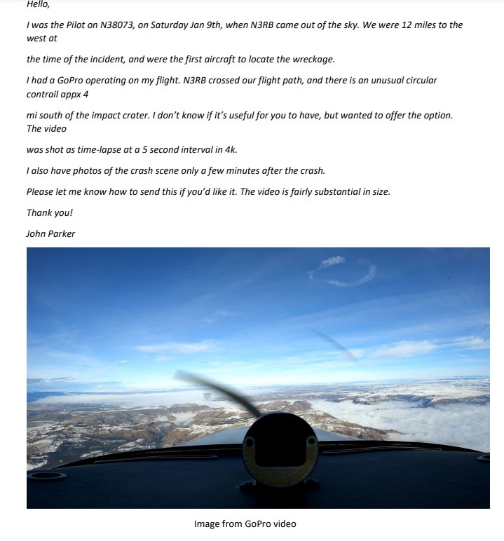
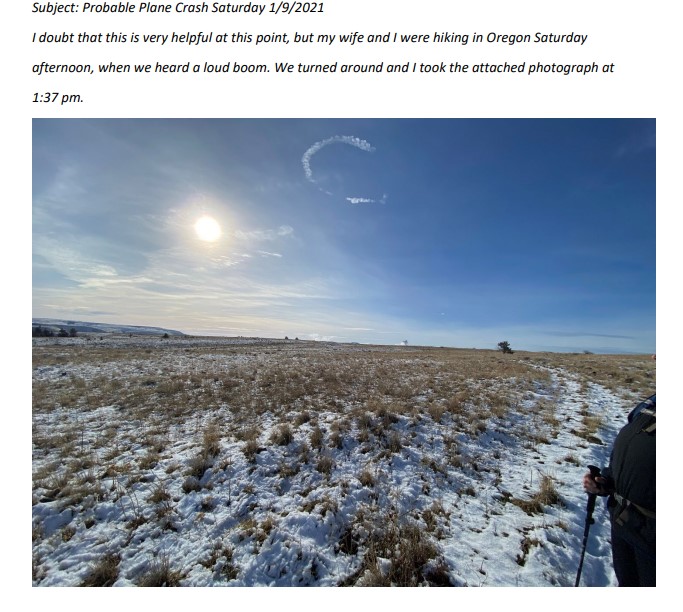
Hikers in the vicinity of the accident took photos of the smoke rising from the debris field. One of the photos captured a single, circular contrail at high altitude above the accident site. Likewise, the pilot of a single-engine airplane flying in the area, was able to capture the circular contrail on a forward-mounted video camera. The images did not reveal any evidence of smoke trails. A commercial airline flight crew overflying the area saw the airplane just before impact and did not see any vapors or smoke trailing from it.

Pilot Information

Certificate: Private 
Age: 72, Male
Airplane Rating(s): Single-engine land; Single-engine sea; Multi-engine land; Multiengine sea
Seat Occupied: Left
Other Aircraft Rating(s): Helicopter 
Restraint Used: 4-point
Instrument Rating(s): Airplane
Second Pilot Present:
Instructor Rating(s): None 
Toxicology Performed:
Medical Certification: Class 2 With waivers/limitations 
Last FAA Medical Exam: September 2, 2020
Occupational Pilot: No 
Last Flight Review or Equivalent:
Flight Time: (Estimated) 12350 hours (Total, all aircraft), 15 hours (Total, this make and model)

The pilot held a private pilot certificate, and although he held type ratings for the Grumman G111 Albatross and Learjet, FAA records did not indicate that he held a type rating for the Citation 560.

The pilot had taken Citation 560 training toward the end of 2020 at a facility in Arizona. The owner of that facility provided some of the flight training and stated that, when the pilot had initially approached him, his plan was to accomplish both his commercial pilot certificate, Citation type rating, and single-pilot exemption consecutively. They developed a custom syllabus to meet these goals; however, after the first few flights, it became apparent that, while the commercial and Citation ratings were possible, the single-pilot exemption would likely take significantly more time to accomplish. The decision was then made to abandon the single-pilot exemption and focus on a “crew method” of training.

As the training progressed, the pilot encountered significant difficulty mastering the operation of the autopilot and the Garmin 750 avionics suite, which had recently been installed. The owner of the training facility stated that the pilot struggled significantly in high-workload environments, such as while flying instrument approaches, where multiple configuration changes needed to be accomplished in a short amount of time, and that the presence of the Garmin 750 appeared to aggravate the situation. He stated that as his instructor/first officer, he was never able to transition from “instructor” into “first officer” mode. The pilot would typically make some progress on one flight, but during following flights, the results could be unpredictable, and the pilot could not make consistent, repeatable progress mastering the airplane. Additionally, although the pilot had a good general grasp of standard airwork, he was struggling in particular with steep turns.

After over a dozen flights over the course of 3 weeks, the training was not complete, and the pilot decided that he needed to leave to take care of some business at home and planned to return later to resume training. At that time, he had not performed to a level sufficient to be issued the type rating.

Since October 2020, the pilot had an arrangement with a contract pilot who flew the accident airplane, while he sat in the right seat. The contract pilot stated that he did not get a chance to see the pilot fly the airplane; however, during one of their flights, the pilot stated that he preferred to “hand fly” the airplane rather than use the autopilot, because he did not consider himself a professional pilot.

Review of historical flight data and statements provided by acquaintances and other pilots who flew with him indicated that the accident flight was likely the first time the pilot had flown the airplane solo.

Aircraft and Owner/Operator Information

Aircraft Make: Cessna
Registration: N3RB
Model/Series: 560 
Aircraft Category: Airplane
Year of Manufacture: 1989
Amateur Built:
Airworthiness Certificate: Normal
Serial Number: 560-0035
Landing Gear Type: Retractable - Tricycle
Seats: 11
Date/Type of Last Inspection: January 6, 2020 Continuous airworthiness
Certified Max Gross Wt.: 16630 lbs
Time Since Last Inspection: 100 Hrs
Engines: 2 Turbo fan
Airframe Total Time: 13727.8 Hrs as of last inspection
Engine Manufacturer: P&W CANADA
ELT: Installed, not activated 
Engine Model/Series: JT15D 5 SER
Registered Owner:
Rated Power: 2900 Lbs thrust
Operator: On file 
Operating Certificate(s) Held: None

Ownership of the airplane was transferred to the pilot in July 2020. As part of the negotiations for sale, an avionics upgrade was performed in April 2020, which included the addition of a Garmin 650 Xi and 750Xi avionics suite, along with a Garmin 335R ADS-B transponder, and a GDL 69A datalink receiver.

The current maintenance records were not located and were presumed to have been destroyed in the accident. The most recent recovered records indicated that a Phase B check was completed on January 6, 2020, at an airframe total time of 13,727.8 flight hours.

The airplane was serviced with 150 gallons of Jet A fuel 6 days before the accident.

Meteorological Information and Flight Plan

Conditions at Accident Site: Visual (VMC)
Condition of Light: Day
Observation Facility, Elevation: DLS, 247 ft msl
Distance from Accident Site: 41 Nautical Miles
Observation Time: 13:53 Local
Direction from Accident Site: 357°
Lowest Cloud Condition: Clear
Visibility 10 miles
Lowest Ceiling: Overcast / 10000 ft AGL
Visibility (RVR):
Wind Speed/Gusts: 8 knots / 
Turbulence Type Forecast/Actual:  /
Wind Direction: 70°
Turbulence Severity Forecast/Actual:  /
Altimeter Setting: 30.4 inches Hg
Temperature/Dew Point: 4°C / 1°C
Precipitation and Obscuration: No Obscuration; No Precipitation
Departure Point: Troutdale, OR (TTD)
Type of Flight Plan Filed: IFR
Destination: Boise, ID (BOI) 
Type of Clearance: IFR
Departure Time: 13:07 Local
Type of Airspace: Class E

Wreckage and Impact Information

Crew Injuries: 1 Fatal
Aircraft Damage: Destroyed
Passenger Injuries:
Aircraft Fire: On-ground
Ground Injuries: 
Aircraft Explosion: None
Total Injuries: 1 Fatal
Latitude, Longitude: 44.996186,-121.13765

Due to the Covid-19 pandemic, neither the NTSB nor the FAA responded to the accident site, and onsite photographic documentation was accomplished by local law enforcement personnel. A complete airframe and engine examination was later performed by representatives from the NTSB, FAA, Textron Aviation, and Pratt and Whitney Canada International at a recovery facility.

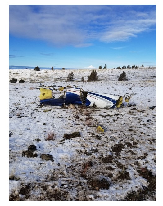
Review of photographs of the accident site revealed a 1,500-ft-long debris field on an approximate heading of 330° magnetic. The entire airplane sustained significant fragmentation and thermal damage, with the right wing displaying the most extensive fragmentation. All major structural and flight control surfaces were recovered in the immediate vicinity of the accident site. The thrust reverser assemblies were found in the stowed position and both engines displayed damage signatures consistent with operation at impact.

There was no evidence of bird strike, in-flight fire, or door opening.

Remnants of three emergency oxygen system mask assemblies were located. Two of the assemblies sustained damage preventing an assessment of their operational status, but the mask for one passenger system remained within its housing assembly, indicating that the oxygen system had not deployed. According to the Pilot’s Operating Handbook, should the cabin altitude exceed 13,500 +/-600 ft, an altitude sensing switch will electrically actuate the passenger solenoid valve, supplying 70-psi oxygen pressure to the passenger manifold. This pressure is sufficient to operate the passenger mask actuators, deploy the doors, and drop the continuous-flow masks at each passenger seat. The oxygen control panel was located; however, the control valve switch was detached, and a determination of its status at the time of the accident could not be ascertained. The valves for the oxygen cylinder were broken off; therefore, the tanks were empty, and their oxygen quantity at impact could not be determined.

Flight recorders 

The airplane was equipped with a cockpit voice recorder that was recovered and sent to the NTSB Recorders Division for data extraction. Examination revealed that the recorder had sustained a pre-existing internal failure and its recording tape contained no information from either the accident or any previous flights.

Medical and Pathological Information

During the 72-year-old pilot’s most recent medical examination, on September 2, 2020, he reported having seasonal allergies and the use of loratadine (Claritin) to treat them. This drug is not considered impairing.

According to the autopsy performed by the Wasco County Medical Examiner’s Office, the cause of death was generalized blunt force trauma and the manner of death was accident. Due to the severity of injury, a limited external examination was performed, and no specimens were submitted for toxicology testing. No natural disease was identified in the limited exam.

According to personal medical records, the pilot had a number of longstanding diagnoses, including anxiety, depression, high blood pressure, seasonal allergies, glaucoma, and high cholesterol.

His regular medications over the year preceding the accident included alprazolam and sertraline for his psychiatric disease, atorvastatin and fenofibrate for his high cholesterol, lisinopril-hydrochlorothiazide for his blood pressure, and three different eye drops to treat his glaucoma. In March 2020, he reported using cetirizine/pseudoephedrine (Zyrtec-D) to treat his seasonal allergies. He did not report the use of these medications during his most recent FAA medical exam.

Alprazolam is an FAA, “Do Not Fly” medication; air medical examiners are instructed not to issue medical certificates to applicants who use it. Sertraline, an SSRI medication, cannot be taken unless authorized by the FAA. The FAA considers cetirizine a conditionally acceptable sedating medication that may be used occasionally one to two times per week, but not for daily use.

Family members and friends of the pilot who listened to the audio recordings of the pilot’s interaction with air traffic control stated that he was generally quiet and soft spoken and that his voice sounded normal to them.

Tests and Research

Performance Study

Interpolation of the ADS-B data during the spiraling descent indicated a right bank angle of between 60° and 70° and a descent rate of between -2,500 to -5,000 ft/min to impact.

The data also revealed 50- to 100-knot oscillations in groundspeed during the descent. The data was compared to flight test data for the Citation 560 series airplane, specifically the data used to simulate the longitudinal, open-loop, long period (or phugoid) response of the airplane after a pitch disturbance.

The data for the accident airplane displayed longitudinal dynamic characteristics that were similar to the flight test data for over a period of oscillation, or approximately 90 seconds.

============

Location: Warm Springs, OR
Accident Number: WPR21LA082
Date & Time: January 9, 2021, 13:36 Local 
Registration: N3RB
Aircraft: Cessna 560 Injuries: 1 Fatal
Flight Conducted Under: Part 91: General aviation - Personal

On January 9, at 1336 Pacific standard time (PST), a Cessna 560, N3RB, was destroyed when it was involved in an accident near Warm Springs, Oregon. The pilot, who was the sole occupant, was fatally injured. The airplane was operated as a Title 14 Code of Federal Regulations Part 91 flight.

The pilot had filed an instrument flight rules (IFR) flight plan to Boise Air Terminal/Gowen Field (BOI), Boise, Idaho. Security video footage from a local fixed base operator at the departure airport in Troutdale, Oregon, revealed that the pilot boarded the airplane and closed the cabin door at 1244. Preliminary FAA air traffic control audio data indicated that about 5 minutes later, he initiated radio contact with the Troutdale clearance controller, and requested to open his IFR clearance. The ground controller provided the clearance, the pilot read it back correctly, and about nine minutes later, the pilot stated that he was ready to taxi and that he had information Foxtrot. The controller stated that information Golf was current, and provided instructions to taxi to runway 07. The pilot replied, but only stated the altimeter setting, “3025”, and the ground controller asked him to respond with the full taxi instructions. The pilot responded, and about 1300 the airplane began to taxi to the runway hold short line.

The airplane arrived at the hold short line about 1304, and the ground controller asked if the pilot was ready for departure, to which he replied, “just a minute”. About two minutes later, a partial transmission of the pilot’s voice could be heard, and the local controller asked twice if it was N3RB. The pilot stated that it was him, and the controller issued a takeoff clearance. The pilot responded, and by 1307 the airplane had taken off. Shortly after departure, the controller requested that the pilot contact Portland Approach/Departure controllers, and he responded in the affirmative.

The pilot then contacted Portland Approach, and was provided instructions to ident and to climb and maintain 15,000 ft. The pilot responded with a partial response of, “up to 15”, following which the controller confirmed radar contact, and provided a heading change left to 310. The pilot did not respond, and airplane did not turn, and over the next minute, both the Portland Approach and Troutdale Tower controller made multiple attempts to contact the pilot. On the fifth attempt by the approach controller, the pilot responded and was provided the left heading. The airplane then began to turn left, and after one minute the controller issued a heading update to 180, and told the pilot to expect vectors for the TIMEE intersection after reaching 10,000 ft. The pilot did not respond until the controller issued the instruction a second time.

About one minute later, the airplane had reached 10,000 ft and was on a southbound track. The controller then issued a clearance direct to the TIMEE intersection. The pilot responded, and the airplane began to turn left, however its heading was about 15° left of what was required to reach the TIMEE intersection.

By 1315:30, the airplane had reached an altitude of 12,000 ft, and the controller asked the pilot to verify he was direct TIMEE. The pilot responded that he was, however, the airplanes track had not changed, and the airplane was now flying directly toward Mount Hood, about 27 miles east-southeast.

After the airplane had reached an altitude of 13,000 ft, the controller issued a right turn to 130, and the pilot responded with the correct readback, however the airplane turned left. The controller asked of the pilot was flying direct TIMEE, to which he replied, “I was”. The controller explained that the pilot was in fact flying on a northeast track, and provided another right heading change to 130. The pilot responded, and the airplane began a right turn, eventually rolling out on a 130 track, following which the controller issued a frequency change to Seattle Center. The pilot responded with the correct frequency but about one minute later, he called back with a confirmation of the Seattle center frequency.

By this time the airplane had reached an altitude of 14,000 ft, and after successfully making contact with Seattle Center, the Seattle controller immediately provided the pilot with a low altitude alert warning, stating that he was just above the minimum IFR altitude for that sector (by this time the airplane was flying just south of the peak of Mount Hood), and issued a clearance to FL 230.

The pilot responded, and the airplane continued to climb. The controller then asked the pilot if he was having problems with his radio, to which responded, “no, I think it’s cleared up now, radio loud and clear”. The controller then issued the pilot with a clearance direct to BOI. 

About 13:23, having reached an altitude of 19,000 ft the pilot was provided a new frequency for Seattle Center. He responded with an incorrect frequency, and was corrected by the controller. The pilot then successfully made contact with the new controller, who issued a clearance to flight level 370. The pilot responded, and the airplane continued to track in the general direction of BOI while continuing to climb.

At the 1327 the airplane had reached an altitude of 27,000 ft when it began to track to the right while continuing to climb. The controller alerted the pilot that he was about 30° right of course, but the pilot did not respond. The airplane continued to climb, until 1328:45, when it reached its highest altitude of 31,000 ft. The airplane began to descend, and remained for the next eight minutes in a spiraling and descending 1-mile radius right turn. The last ADS-B target was recorded at 1336:27, with the airplane on a northwest heading at an altitude of 3,800 ft.

The airplane struck the ground in the Mutton Mountain Range, at an elevation of 3,600 ft. Review of photos of the accident site revealed a 1,500 ft long debris field on an approximate heading of 330° magnetic. The entire airplane sustained heavy fragmentation and thermal damage. The cockpit voice recorder was recovered, and sent to the NTSB Recorders Division for data extraction, and the wreckage was recovered to an off-site facility for further examination.

The pilot held a private pilot certificate, and although he held type ratings for the Grumman G-111 Albatross and Learjet, FAA records did not indicate that he held a type rating for the Citation 560. He had taken Citation 560 training toward the end of 2020 at a training facility in Arizona, however the owner of the facility stated that the pilot had not performed to a level sufficient to be issued a type rating or single pilot exemption.

Review of historical flight data, and statements provided by acquaintances of the pilot, indicate that this was likely the first time he had flown the airplane on his own.

Aircraft and Owner/Operator Information

Aircraft Make: Cessna
Registration: N3RB
Model/Series: 560 
Aircraft Category: Airplane
Amateur Built: No
Operator: 
Operating Certificate(s) Held: None
Operator Designator Code:

Meteorological Information and Flight Plan

Conditions at Accident Site: VMC
Condition of Light: Day
Observation Facility, Elevation: DLS,247 ft msl
Observation Time: 13:53 Local
Distance from Accident Site: 41 Nautical Miles 
Temperature/Dew Point: 4°C /1°C
Lowest Cloud Condition: Clear 
Wind Speed/Gusts, Direction: 8 knots / , 70°
Lowest Ceiling: Overcast / 10000 ft AGL
Visibility: 10 miles
Altimeter Setting: 30.4 inches Hg 
Type of Flight Plan Filed: IFR
Departure Point: Troutdale, OR (TTD)
Destination: Boise, ID (BOI)

Wreckage and Impact Information

Crew Injuries: 1 Fatal
Aircraft Damage: Destroyed
Passenger Injuries: 
Aircraft Fire: On-ground
Ground Injuries: 
Aircraft Explosion: None
Total Injuries: 1 Fatal
Latitude, Longitude: 44.996186,-121.13765


Richard Boehlke


Rico Boehlke at his second of three Fort Lauderdale, Florida, homes during Thanksgiving 2020.


Richard "Rick" Boehlke died January 9, 2021 in his private airplane.

Rick was born and raised in Portland, Ore. He graduated from John Marshall High School and attended Pacific Lutheran University where he completed his undergraduate degree and masters degree in Business. He was a visionary in the Senior Housing Industry. His accomplishments included; VP The Hillhaven Corporation, Exec VP Tenet Healthcare, Founder, Chairman & CEO Crossings Corporation, Co-founder Alterra Healthcare-Brookdale Senior Living and most recently Chairman, CEO Senexus Companies.

Rick's passion was flying.

Rick leaves behind his best friend, Rio; brother, sister, their spouses, niece, and nephews.

Cessna Citation 560, N561EJ: Incident occurred January 24, 2012 at Orange County Airport (KORG), Texas


ORANGE COUNTY - There are no injuries resulting from what investigators describe as a private jet crash in Orange County, according to information KFDM News has received from the Texas Department of Public Safety and Capt. Joe Mires with the Orange Fire Department.

The crash was reported at about 10 a.m. at the Orange County Airport.

The pilot, Claude Edward Collins, said the runway was wet, causing the Cessna 560 Citation to slide off the paved runway during landing at about 10 a.m., according to Trooper Stephanie Davis with the Texas Department of Public Safety.

A spokesman for Orange County says a wind gust pushed the plane off the runway, causing the nose gar to collapse.

The pilot wasn't hurt. The jet's front landing gear was damaged. The pilot had flown from Alabama to Orange County. 

The Orange Fire Department and law enforcement officers responded to the call.

The Federal Aviation Administration and the National Transportation Safety Board were notified.

The Orange County Airport will be closed until further notice pending clearance from the FAA and NTSB for cleanup

The Orange County Emergency Management office has reported a jet aircraft carrying nine people, slid off runway at the Orange County Airport at approximately 10:03 a.m. today.

Reports indicate the jet came in for landing and a wind gust pushed the airplane off the runway, causing the nose gear to collapse.

The names of those on board the plane were not released and no injuries have been reported.

Officers from the Texas Department of Public Safety were on the scene to help assist. Sergeant Richard Howard with the DPS office said the FAA has been notified and the Orange County Airport will be closed until further notice pending clearance from the FAA and NTSB for cleanup.

The Texas Department of Public Safety says the accident happened around 10 a.m. Tuesday at the Orange County Airport near Orange, about 100 miles northeast of Houston.

Airport spokeswoman Jill Shores says wind gusts also helped pushed the aircraft from the runway on a morning when the area had rainstorms.

Trooper Stephanie Davis identified the pilot of the Cessna 560 as Claude Edward Collins.

DPS had no immediate details on where the flight originated in Alabama or the owner of the twin-engine jet, which suffered landing gear damage in the accident.

Airport spokeswoman Jill Shores says wind gusts also helped pushed the aircraft from the runway on a morning when the area had rainstorms.