


Additional Participating Entity:
Federal Aviation Administration / Flight Standards District Office; Greensboro, North Carolina
Investigation Docket - National Transportation Safety Board:
CraigAir LLC
Location: Pinehurst, North Carolina
Accident Number: ERA22LA125
Date and Time: February 9, 2022, 17:48 Local
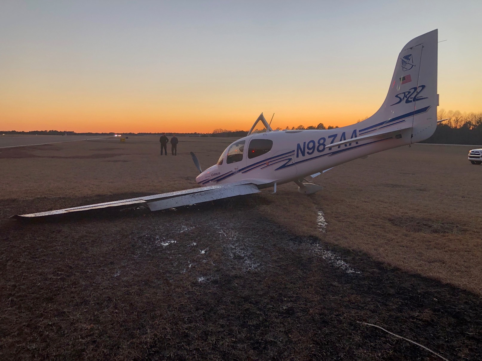
Registration: N987AA
Aircraft: CIRRUS DESIGN CORP SR22
Aircraft Damage: Substantial
Defining Event: Inflight upset
Injuries: 2 None
Flight Conducted Under: Part 91: General aviation - Personal
Analysis
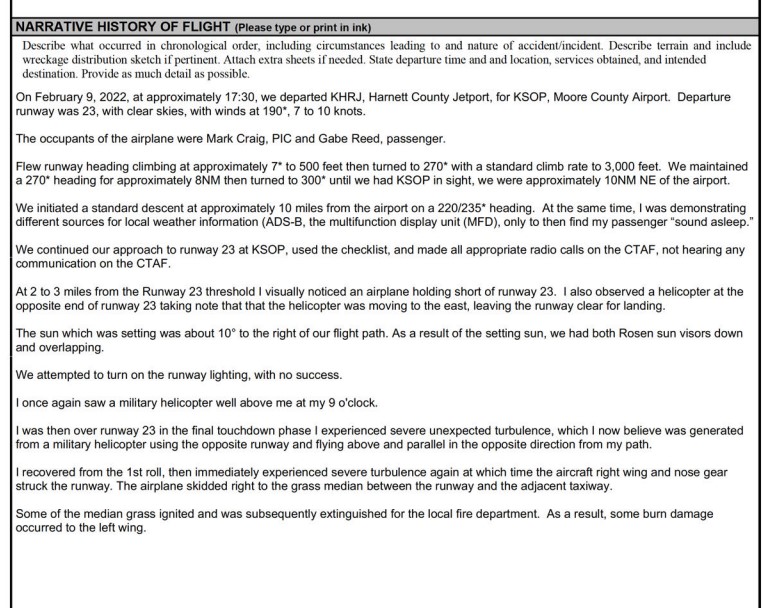
The Cirrus pilot reported making a radio call on what he thought was the published common traffic advisory frequency (CTAF) when the flight was 10 miles away, then continued to the airport for a straight-in approach to runway 23 making radio calls. During the same time frame, a flightcrew member of an Army helicopter announced on the CTAF when their flight was on 10, 5, and 2 nautical mile final
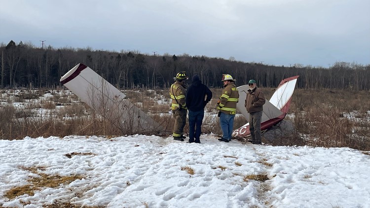
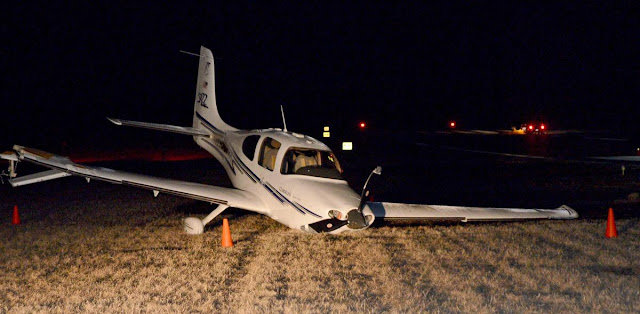
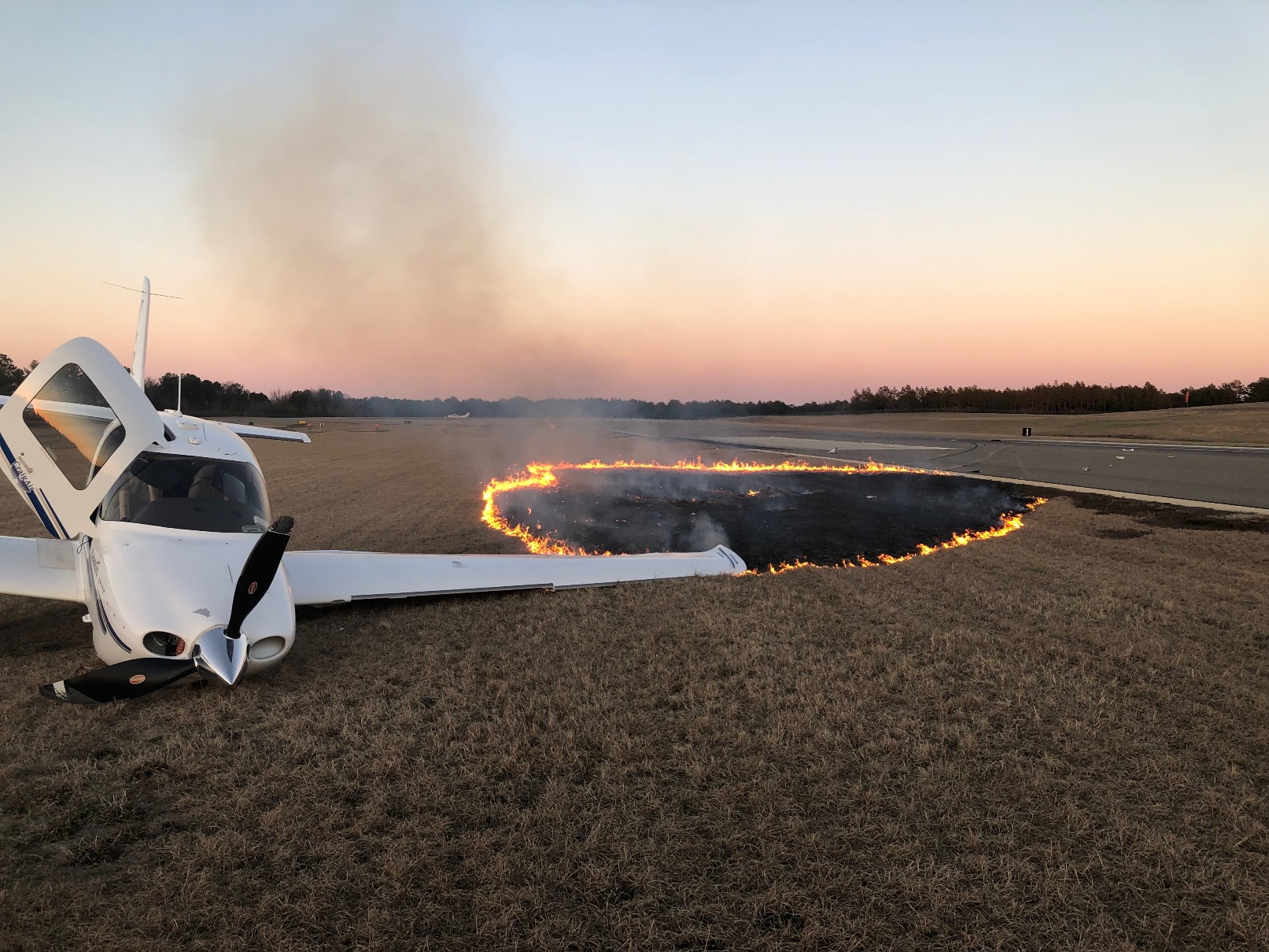
for runway 5. The Cirrus pilot indicated that he did not hear any communication on the CTAF and he was unable to activate the runway lights using the CTAF. When the Cirrus flight was between 2 and 3 miles from the airport, he saw a helicopter at the opposite end of the runway moving to the east, adding that the sun was in his eyes which was “definitely a factor.” He did not hear the helicopter on the selected CTAF frequency and made a radio call on the CTAF that he was on short final approach. A flightcrew member of the military helicopter reported they did not hear any advisory call from the airplane and after they spotted it, the IP took the controls and turned to the right (east) to avoid a collision. The Cirrus pilot indicated that after flying over the airport property fence, he looked to his left and noted a military helicopter several hundred feet above his altitude. He continued his descent to runway 23 and when the flight was about 15 to 20 ft AGL the flight encountered, “very strong turbulence” which caused the left wing to drop. He recovered from that and then when the flight was between 5 and 10 ft AGL encountered another round of “very strong turbulence” which made the right wing contact the runway resulting in substantial damage to the wing. The airplane went to the right and skidded into the grass. The military helicopter continued to the east and reported that since they could not affect the situation continued with the training.
A short audio recording of the CTAF recorded a flightcrew member of the military helicopter announcing they were on a 2 mile final for runway 5, followed by an announcement that they were departing to the east off of runway centerline.
Postaccident examination of the radios of the Cirrus airplane revealed the pilot had selected the #2 radio to transmit, which was set to 122.700 MHz. That frequency was the departure airport CTAF. The accident airport published CTAF was 123.05MHz.
Probable Cause and Findings
The National Transportation Safety Board determines the probable cause(s) of this accident to be:
The in-flight encounter while on final approach with high-speed trailing vortices from a military helicopter, resulting in abnormal runway contact. Contributing to the accident was the Cirrus pilot’s incorrect selection of the common traffic advisory frequency on the aircraft’s radio.
Findings
Environmental issues (general) - Effect on operation
Personnel issues Use of equip/system - Pilot
Factual Information
History of Flight
Approach-VFR pattern final Inflight upset (Defining event)
Approach-VFR pattern final Loss of control in flight
Landing-flare/touchdown Abnormal runway contact
Pilot Information
Certificate: Private
Age: 70, Male
Airplane Rating(s): Single-engine land
Seat Occupied: Left
Other Aircraft Rating(s): None
Restraint Used: 4-point
Instrument Rating(s): Airplane
Second Pilot Present: No
Instructor Rating(s): None
Toxicology Performed:
Medical Certification: Class 3 With waivers/limitations
Last FAA Medical Exam: December 21, 2021
Occupational Pilot: No
Last Flight Review or Equivalent: June 25, 2020
Flight Time: (Estimated) 1468.6 hours (Total, all aircraft), 1369 hours (Total, this make and model), 1469 hours (Pilot In Command, all aircraft), 65 hours (Last 90 days, all aircraft), 12.5 hours (Last 30 days, all aircraft), 3.1 hours (Last 24 hours, all aircraft)
Aircraft and Owner/Operator Information
Aircraft Make: CIRRUS DESIGN CORP
Registration: N987AA
Model/Series: SR22 NO SERIES
Aircraft Category: Airplane
Year of Manufacture: 2003
Amateur Built:
Airworthiness Certificate: Normal
Serial Number: 0513
Landing Gear Type: Tricycle
Seats: 4
Date/Type of Last Inspection: August 6, 2021 Annual
Certified Max Gross Wt.: 3400 lbs
Time Since Last Inspection:
Engines: 1 Reciprocating
Airframe Total Time: 2409 Hrs as of last inspection
Engine Manufacturer: Continental
ELT: C126 installed, activated, did not aid in locating accident
Engine Model/Series: IO-550-N7B
Registered Owner:
Rated Power: 310 Horsepower
Operator: On file
Operating Certificate(s) Held: None
Meteorological Information and Flight Plan
Conditions at Accident Site: Visual (VMC)
Condition of Light: Dusk
Observation Facility, Elevation: KSOP,461 ft msl
Distance from Accident Site: 0 Nautical Miles
Observation Time: 17:56 Local
Direction from Accident Site: 255°
Lowest Cloud Condition: Clear
Visibility 10 miles
Lowest Ceiling: None
Visibility (RVR):
Wind Speed/Gusts: /
Turbulence Type Forecast/Actual: Unknown / None
Wind Direction:
Turbulence Severity Forecast/Actual: Unknown / N/A
Altimeter Setting: 29.98 inches Hg
Temperature/Dew Point: 10°C / -1°C
Precipitation and Obscuration: No Obscuration; No Precipitation
Departure Point: Erwin, NC (HRJ)
Type of Flight Plan Filed: None
Destination: Pinehurst, NC
Type of Clearance: None
Departure Time: 17:32 Local
Type of Airspace:
Airport Information
Airport: MOORE COUNTY SOP
Runway Surface Type: Asphalt
Airport Elevation: 459 ft msl
Runway Surface Condition: Dry
Runway Used: 23
IFR Approach: None
Runway Length/Width: 6503 ft / 150 ft
VFR Approach/Landing: Full stop; Straight-in
Wreckage and Impact Information
Crew Injuries: 1 None
Aircraft Damage: Substantial
Passenger Injuries: 1 None
Aircraft Fire: On-ground
Ground Injuries:
Aircraft Explosion: None
Total Injuries: 2 None
Latitude, Longitude: 35.237423,-79.389034 (est)


HOURS estimated from logbooks or other information - not guaranteed or warranted
AIRCRAFT: 2003 Cirrus SR22 N987AA, s/n: 0513
The last Annual Inspection is dated 08/06/2021 at Hobbs 2409.4.
The last log entry on 02/10/2022 records Hobbs 2567.9
ENGINE: Continental IO-550N, s/n: 686819.
The last annual inspection entry is date 08/06/2021 and notes Hobbs 2409.4
PROPELLER: Hartzell PHC-J3YF-1RF, s/n: FP2163B
Prop Annual inspection recorded in the engine log on 08/06/21 at Hobbs 2409.4
DESCRIPTION OF ACCIDENT: On February 09, 2022, N987AA was damaged while landing at Moore County Airport, North Carolina
LOCATION OF AIRCRAFT: AMF Aviation LLC, Springfield, Tennessee
REMARKS:
Insurer reserves the right to reject any and all bids.
Salvage is as is/where is.
The posting information is the best to our knowledge.
An inspection of the salvage is highly recommended.
Logbooks may not be complete.
Read more here: http://www.avclaims.com