Friday, December 31, 2021

Loss of Control on Ground: Cessna 170B, N2218B; accident occurred June 11, 2021 at Frank Wiley Field Airport (KMLS), Miles City, Custer County, Montana


Aviation Accident Final Report - National Transportation Safety Board 

The National Transportation Safety Board did not travel to the scene of this accident.

Additional Participating Entity:
Federal Aviation Administration / Flight Standards District Office; Helena, Montana 

Investigation Docket - National Transportation Safety Board:


Location: Miles City, Montana
Accident Number: WPR21LA226
Date and Time: June 11, 2021, 17:00 Local 
Registration: N2218B
Aircraft: Cessna 170B 
Aircraft Damage: Substantial
Defining Event: Loss of control on ground
Injuries: 2 None
Flight Conducted Under: Part 91: General aviation - Personal

Analysis

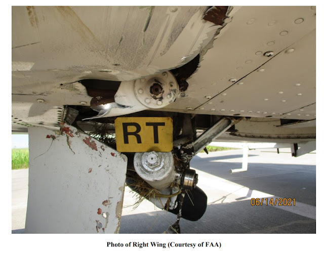
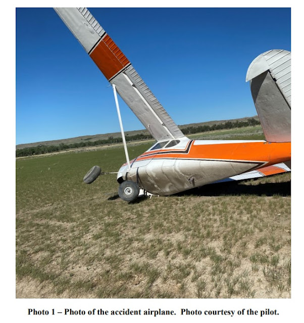
The pilot of the tailwheel equipped airplane reported that, during takeoff from a field, the airplane veered to the left. While attempting to correct with right rudder control and brake application, the left main landing gear went into a rut and the airplane subsequently ground looped. The airplane sustained substantial damage to the right wing, right horizontal, and right elevator. The pilot reported that there were no preaccident mechanical failures or malfunctions with the airplane that would have precluded normal operation.

Probable Cause and Findings

The National Transportation Safety Board determines the probable cause(s) of this accident to be:
The pilot’s failure to maintain directional control during takeoff which resulted in a ground loop and collision with terrain.

Findings

Aircraft Directional control - Not attained/maintained
Personnel issues Aircraft control - Pilot
Environmental issues Rough terrain - Contributed to outcome

Factual Information

History of Flight

Takeoff Loss of control on ground (Defining event)
Takeoff Collision with terr/obj (non-CFIT)

Pilot Information

Certificate: Private 
Age: 37, Male
Airplane Rating(s): Single-engine land 
Seat Occupied: Left
Other Aircraft Rating(s): None 
Restraint Used: Lap only
Instrument Rating(s): None 
Second Pilot Present:
Instructor Rating(s): None 
Toxicology Performed:
Medical Certification: Class 3 Without waivers/limitations
Last FAA Medical Exam: January 2, 2018
Occupational Pilot: No 
Last Flight Review or Equivalent: April 26, 2020
Flight Time: 342 hours (Total, all aircraft), 241 hours (Total, this make and model), 55 hours (Last 90 days, all aircraft), 25 hours (Last 30 days, all aircraft)

Aircraft and Owner/Operator Information

Aircraft Make: Cessna 
Registration: N2218B
Model/Series: 170B 
Aircraft Category: Airplane
Year of Manufacture: 1954 
Amateur Built:
Airworthiness Certificate: Normal
Serial Number: 26438
Landing Gear Type: Tailwheel 
Seats: 4
Date/Type of Last Inspection: August 21, 2020 Annual
Certified Max Gross Wt.: 2200 lbs
Time Since Last Inspection: 
Engines: 1 Reciprocating
Airframe Total Time: 7022 Hrs as of last inspection 
Engine Manufacturer: Lycoming
ELT: Not installed 
Engine Model/Series: IO-360
Registered Owner:
Rated Power: 180
Operator: On file
Operating Certificate(s) Held: None

Meteorological Information and Flight Plan

Conditions at Accident Site: Visual (VMC)
Condition of Light: Day
Observation Facility, Elevation: KMLS, 2634 ft msl 
Distance from Accident Site: 23 Nautical Miles
Observation Time: 17:53 Local 
Direction from Accident Site: 271°
Lowest Cloud Condition: Few / 200 ft AGL
Visibility:  6 miles
Lowest Ceiling: None
Visibility (RVR):
Wind Speed/Gusts: 12 knots / 
Turbulence Type Forecast/Actual: None / None
Wind Direction: 280° 
Turbulence Severity Forecast/Actual: N/A / N/A
Altimeter Setting: 29.95 inches Hg
Temperature/Dew Point: 24°C / -2°C
Precipitation and Obscuration: Moderate - None - Haze
Departure Point: Miles City, MT
Type of Flight Plan Filed: None
Destination: Laurel, MT 
Type of Clearance: None
Departure Time: 
Type of Airspace: Class G

Wreckage and Impact Information

Crew Injuries: 1 None
Aircraft Damage: Substantial
Passenger Injuries: 1 None 
Aircraft Fire: None
Ground Injuries: 
Aircraft Explosion: None
Total Injuries: 2 None 
Latitude, Longitude: 46.41905,-105.32086 (est)

Collision with Object (non-CFIT): Piper PA-28-150 Cherokee, N5853W; accident occurred June 12, 2021 at Covey Trails Airport (X09), Fulshear, Fort Bend County, Texas


Aviation Accident Final Report - National Transportation Safety Board

The National Transportation Safety Board did not travel to the scene of this accident. 

Additional Participating Entity: 

Federal Aviation Administration / Flight Standards District Office; Houston, Texas

Investigation Docket - National Transportation Safety Board:
Location: Fulshear, Texas
Accident Number: CEN21LA282
Date and Time: June 12, 2021, 08:50 Local 
Registration: N5853W
Aircraft: Piper PA-28-150 
Aircraft Damage: Substantial
Defining Event: Collision with terr/obj (non-CFIT) 
Injuries: 1 None
Flight Conducted Under: Part 91: General aviation - Personal

Analysis

The pilot reported that while on approach to land, he allowed the airplane to get too low and struck a fence before the approach end of the runway. The airplane sustained substantial damage to both wings. The pilot reported that there were no preimpact mechanical failures or malfunctions with the airplane that would have precluded normal operation.

Probable Cause and Findings

The National Transportation Safety Board determines the probable cause(s) of this accident to be:
The pilot’s failure to maintain a proper glidepath during the landing approach, which led to an impact with a fence.

Findings

Aircraft Descent/approach/glide path - Not attained/maintained
Personnel issues Aircraft control - Pilot
Environmental issues Fence/fence post - Not specified

Factual Information

History of Flight

Landing Collision with terr/obj (non-CFIT) (Defining event)

Pilot Information

Certificate: Private 
Age: 80, Male
Airplane Rating(s): Single-engine land
Seat Occupied: Left
Other Aircraft Rating(s): None 
Restraint Used: 3-point
Instrument Rating(s): Airplane 
Second Pilot Present:
Instructor Rating(s): None 
Toxicology Performed:
Medical Certification: BasicMed 
Last FAA Medical Exam:
Occupational Pilot: No
Last Flight Review or Equivalent:
Flight Time: 1587 hours (Total, all aircraft), 421 hours (Total, this make and model)

Aircraft and Owner/Operator Information

Aircraft Make: Piper
Registration: N5853W
Model/Series: PA-28-150 
Aircraft Category: Airplane
Year of Manufacture: 1965
Amateur Built:
Airworthiness Certificate: Normal
Serial Number: 28-2322
Landing Gear Type: Tricycle 
Seats: 4
Date/Type of Last Inspection: Unknown 
Certified Max Gross Wt.:
Time Since Last Inspection:
Engines: 1 Reciprocating
Airframe Total Time:
Engine Manufacturer: Lycoming
ELT: 
Engine Model/Series: O-320
Registered Owner:
Rated Power:
Operator: On file
Operating Certificate(s) Held: None

Meteorological Information and Flight Plan

Conditions at Accident Site: Visual (VMC) 
Condition of Light: Day
Observation Facility, Elevation: KTME,168 ft msl 
Distance from Accident Site: 7 Nautical Miles
Observation Time: 09:55 Local
Direction from Accident Site: 335°
Lowest Cloud Condition: Clear 
Visibility: 9 miles
Lowest Ceiling: None 
Visibility (RVR):
Wind Speed/Gusts: / 
Turbulence Type Forecast/Actual:  /
Wind Direction:
Turbulence Severity Forecast/Actual:  /
Altimeter Setting: 30.01 inches Hg
Temperature/Dew Point: 29°C / 25°C
Precipitation and Obscuration: No Obscuration; No Precipitation
Departure Point: Fulshear, TX
Type of Flight Plan Filed: None
Destination: Fulshear, TX
Type of Clearance: None
Departure Time: 
Type of Airspace:

Airport Information

Airport: COVEY TRAILS X09 
Runway Surface Type: Grass/turf
Airport Elevation: 130 ft msl 
Runway Surface Condition: Dry
Runway Used: 17/35
IFR Approach: None
Runway Length/Width: 3352 ft / 100 ft
VFR Approach/Landing: Full stop; Traffic pattern

Wreckage and Impact Information

Crew Injuries: 1 None 
Aircraft Damage: Substantial
Passenger Injuries: N/A
Aircraft Fire: None
Ground Injuries:
Aircraft Explosion: None
Total Injuries: 1 None
Latitude, Longitude: 29.690083,-95.840474

Loss of Control on Ground: Cessna 172M, N20406; accident occurred June 12, 2021 in Fields, Harney County, Oregon


Aviation Accident Final Report - National Transportation Safety Board

The National Transportation Safety Board did not travel to the scene of this accident. 

Additional Participating Entity:
Federal Aviation Administration / Flight Standards District Office; Portland, Oregon

Investigation Docket - National Transportation Safety Board:
Location: Fields, Oregon
Accident Number: WPR21LA230
Date and Time: June 12, 2021, 09:45 Local
Registration: N20406
Aircraft: Cessna 172
Aircraft Damage: Substantial
Defining Event: Loss of control on ground
Injuries: 1 None
Flight Conducted Under: Part 91: General aviation - Personal

Analysis

The pilot reported that, he initiated a landing on a highway near a remote town for lunch. After touchdown, the airplane veered left, and the pilot applied full right rudder control input, but the airplane exited the roadway surface and impacted terrain. The airplane nosed over, and the right-wing lift strut and empennage sustained substantial damage. The pilot reported that there were no preaccident mechanical malfunctions or failures with the airplane that would have precluded normal operation.

Probable Cause and Findings

The National Transportation Safety Board determines the probable cause(s) of this accident to be:
The pilot’s failure to maintain directional control during landing on a highway, which resulted in an impact with terrain and subsequent nose over.

Findings

Aircraft Directional control - Not attained/maintained
Personnel issues Aircraft control - Pilot
Environmental issues Rough terrain - Effect on operation

Factual Information

History of Flight

Landing-flare/touchdown Loss of control on ground (Defining event)
Landing-landing roll Collision during takeoff/land

Pilot Information

Certificate: Private 
Age: 64, Male
Airplane Rating(s): Single-engine land 
Seat Occupied: Left
Other Aircraft Rating(s): None
Restraint Used: 3-point
Instrument Rating(s): None 
Second Pilot Present: No
Instructor Rating(s): None 
Toxicology Performed:
Medical Certification: Class 3 With waivers/limitations 
Last FAA Medical Exam: March 24, 2020
Occupational Pilot: No 
Last Flight Review or Equivalent: June 9, 2021
Flight Time: (Estimated) 338.4 hours (Total, all aircraft), 310.8 hours (Total, this make and model), 251.8 hours (Pilot In Command, all aircraft), 11.7 hours (Last 90 days, all aircraft), 10.6 hours (Last 30 days, all aircraft), 1.3 hours (Last 24 hours, all aircraft)

Aircraft and Owner/Operator Information

Aircraft Make: Cessna
Registration: N20406
Model/Series: 172 M
Aircraft Category: Airplane
Year of Manufacture: 1972
Amateur Built:
Airworthiness Certificate: Normal; Utility 
Serial Number: 17261265
Landing Gear Type: Tricycle
Seats: 4
Date/Type of Last Inspection: December 23, 2020 Annual
Certified Max Gross Wt.: 2300 lbs
Time Since Last Inspection: 42 Hrs 
Engines: 1 Reciprocating
Airframe Total Time: 5856.2 Hrs at time of accident
Engine Manufacturer: Lycoming
ELT: Installed, not activated 
Engine Model/Series: 0-320-E2D
Registered Owner: 
Rated Power:
Operator: 
Operating Certificate(s) Held: None

Meteorological Information and Flight Plan

Conditions at Accident Site: Visual (VMC)
Condition of Light: Day
Observation Facility, Elevation: KREO, 4050 ft msl 
Distance from Accident Site: 41 Nautical Miles
Observation Time: 08:52 Local 
Direction from Accident Site: 61°
Lowest Cloud Condition: 
Visibility:
Lowest Ceiling: 
Visibility (RVR):
Wind Speed/Gusts: / 
Turbulence Type
Forecast/Actual: None / None
Wind Direction: 
Turbulence Severity Forecast/Actual: N/A / N/A
Altimeter Setting: 30.1 inches Hg 
Temperature/Dew Point: 18°C / 7°C
Precipitation and Obscuration: No Obscuration; No Precipitation
Departure Point: Burns, OR (KNBO)
Type of Flight Plan Filed: None
Destination: Fields, OR 
Type of Clearance: None
Departure Time: 09:30 Local
Type of Airspace: Class G

Wreckage and Impact Information

Crew Injuries: 1 None 
Aircraft Damage: Substantial
Passenger Injuries:
Aircraft Fire: None
Ground Injuries:
Aircraft Explosion: None
Total Injuries: 1 None 
Latitude, Longitude: 42.264206,-118.67499 (est)

J & J Ultralights SeaWing, N285SW: Fatal accident occurred December 30, 2021 near Table Rock Airport (MO32), Golden, Barry County, Missouri

This is preliminary information, subject to change, and may contain errors. Any errors in this report will be corrected when the final report has been completed.

The National Transportation Safety Board did not travel to the scene of this accident.

Additional Participating Entity:
Federal Aviation Administration / Flight Standards District Office; Kansas City, Missouri


Location: Golden, Missouri
Accident Number: CEN22LA087
Date and Time: December 30, 2021, 15:14 Local
Registration: N285SW
Aircraft: J&J ULTRALIGHTS SEAWING
Injuries: 1 Fatal
Flight Conducted Under: Part 91: General aviation - Personal

On December 30, 2021, about 1514 central standard time, a J&J Ultralights Seawing, N285SW, was substantially damaged when it was involved in an accident near Table Rock Airport (MO32), Golden, Missouri. The uncertificated pilot sustained fatal injuries. The airplane was operated as a Title 14 Code of Federal Regulations Part 91 personal flight.

A video of the accident captured the weight shift aircraft immediately after takeoff from MO32. About 100 ft agl on departure leg, the aircraft pitched up and banked left, then transitioned into a steep dive. The aircraft recovered toward level flight, then pitched up and banked left again. While in the left bank, the aircraft entered a steep dive and impacted a house. Engine noise was observed during the entire video sequence. Postaccident examination of the engine and airframe revealed no evidence of any preaccident mechanical malfunctions or failures that would have precluded normal operation.

Aircraft and Owner/Operator Information

Aircraft Make: J&J ULTRALIGHTS
Registration: N285SW
Model/Series: SEAWING
Aircraft Category: Weight-shift
Amateur Built:
Operator: On file 
Operating Certificate(s) Held: None
Operator Designator Code:

Meteorological Information and Flight Plan

Conditions at Accident Site: VMC
Condition of Light: Day
Observation Facility, Elevation: KFWB, 1349 ft msl
Observation Time: 15:15 Local
Distance from Accident Site: 17 Nautical Miles
Temperature/Dew Point: 16°C /7°C
Lowest Cloud Condition: Clear 
Wind Speed/Gusts, Direction: 4 knots / , 240°
Lowest Ceiling: None
Visibility: 10 miles
Altimeter Setting: 29.77 inches Hg
Type of Flight Plan Filed: None
Departure Point: Golden, MO (MO32)
Destination: Golden, MO (MO32)

Wreckage and Impact Information

Crew Injuries: 1 Fatal 
Aircraft Damage: Substantial
Passenger Injuries:
Aircraft Fire: On-ground
Ground Injuries: 
Aircraft Explosion: None
Total Injuries: 1 Fatal 
Latitude, Longitude: 36.529123,-93.682286 (est)

Those who may have information that might be relevant to the National Transportation Safety Board (NTSB) investigation may contact them by email witness@ntsb.gov, and any friends and family who want to contact investigators about the accident should email assistance@ntsb.gov. You can also call the NTSB Response Operations Center at 844-373-9922 or 202-314-6290.
 
Phillip Taylor
May 15, 1968 - December 30, 2021


Phillip Kenneth Taylor, age 53, of Golden, Missouri, passed away on Thursday, December 30, 2021. Son of Frank and Janie (Harper) Taylor, Phillip was born on May 15, 1968, in Malvern, Arkansas. Subsequent to graduating high school, Phillip served proudly in the United States Army, going on to obtain an aviation degree and a private pilot license. Phillip was a man of many professional interests, becoming a certified welder, crane operator and a registered emergency medical technician. On December 17, 1996, in Narrows, Virginia, Phillip married the love of his life, Chasity O’Dell.  

Phillip was in a band since the age of 12, the most recent of which called “Rekindled”. Phillip could fix or build anything. He was an expert bowman and loved bow hunting. Phillip was a DJ, a songwriter, a drummer, a fisherman, and a hunter. He loved riding his Harley Davidson and cooking. Everything Phillip did was an adventure, and he could make even the simplest things exciting. Phillip was a man who lived big and loved even bigger. As diverse as his interests were, Phillip’s family always came first, no matter what, especially his grandchildren. Phillip was a treasure to all who knew and loved him, he will be greatly missed. 

Survivors include his wife, Chasity Taylor, of Golden, Missouri; his mother, Janie Taylor-Wright, of West Plains, Missouri; five children, Justin Cook, of Golden, Missouri, Felicia Cook and her husband Johnathan, of Corrigan, Texas, Hailey Jamison and her husband Tim, of Fort Knox, Kentucky, Triston Taylor and his wife Devin, of Eagle Rock, Missouri, and Shelby Taylor of Kimberling City, Missouri; eight grandchildren, Aubrie, Johnathan “Bubba”, Harmoni, Harlyn, Audrey, Layla, Sebastian, and Mazeabella; two sisters, Lynn Taylor, of West Plains, Missouri, and Shelby Weese and her husband Wayne, of Elk View, West Virginia; five nephews, Scott Stevenson, of Teays Valley, West Virginia, Kyle Stevenson of Rosharon, Texas, Brandon Weese of Elk View, West Virginia, Chris Simmons, of Saraland, Alabama, and Matthew Simmons, of Ozark Acres, Arkansas; and one niece, Melissa Terry, of West Plains, Missouri. 

Phillip was preceded in death by his father, Frank Taylor; and two granddaughters, Willow Jo Taylor and Kali Cook. 

Funeral Services will be held at 2:00 p.m. on Thursday, January 6, 2022, at White Funeral Home in Cassville Missouri, with Brother Raymond Taylor of Journey Church Ozarks in West Plains, Missouri officiating, with burial to follow at the family farm in Golden.  The family will be receiving friends at the funeral home from 11:00 a.m. until service time. 

Memorial contributions may be made to the family and entrusted to White Funeral Home & Crematory P.O. Box 890, Cassville, MO 65625 

Arrangements are under the direction of White Funeral Home & Crematory, Cassville, Missouri. 


GOLDEN, Missouri — Barry County, Missouri authorities say a southwest Missouri man was killed when his weight shift aircraft crashed last Thursday, December 30, 2021.

Barry County Sheriff Danny Boyd said Kenneth P. Taylor, 53, of Golden, was killed in the crash near Eagle Rock.

Boyd says the weight shift aircraft flew about 500 feet before it hit a nearby home, 27483 Lake Point Drive, and crashed.

It was Taylor’s first solo flight in the weight shift aircraft. He had just taken off from Table Rock Lake Airport.

Sources tell us the plane clipped the roof of the residence and Taylor was ejected from the weight shift aircraft.

FAA investigators were responding to investigate the crash.

Loss of Control on Ground: Cessna 172R Skyhawk, N430EP; accident occurred June 13, 2021 at Groton - New London Airport (KGON), Connecticut


Aviation Accident Final Report - National Transportation Safety Board
 

The National Transportation Safety Board did not travel to the scene of this accident. 

Additional Participating Entity: 
Federal Aviation Administration / Flight Standards District Office; Windsor Locks

Investigation Docket - National Transportation Safety Board:

Sunshine Holding LLC

Arrow Aviation LLLC


Location: Groton, Connecticut
Accident Number: ERA21LA249
Date and Time: June 13, 2021, 17:00 Local 
Registration: N430EP
Aircraft: Cessna 172R 
Aircraft Damage: Substantial
Defining Event: Loss of control on ground 
Injuries: 1 None
Flight Conducted Under: Part 91: General aviation - Instructional

Analysis

The student pilot reported that he was flying a visual approach at the conclusion of a solo cross-country flight. Following a reportedly normal approach and landing, when the nose landing gear contacted the runway, the airplane began to veer to the left and “tilted somewhat.” The airplane then quickly veered further left and departed the runway surface. The airplane collided with a runway distance sign and came to a stop in the grass.

According to an inspector with the Federal Aviation Administration, the airplane’s horizontal stabilizer and elevator were substantially damaged. He performed an examination of the flight controls, wheels, and wheel brakes; no evidence of a preexisting mechanical malfunction or failure was found. There was a tire skid mark on the runway, leading from the runway centerline to the wreckage.

Probable Cause and Findings

The National Transportation Safety Board determines the probable cause(s) of this accident to be:
The pilot’s failure to maintain directional control of the airplane during landing, resulting in a runway excursion and collision with an airport sign.

Findings
Aircraft Directional control - Not attained/maintained
Personnel issues Aircraft control - Pilot

Factual Information

History of Flight

Landing-landing roll Loss of control on ground (Defining event)
Landing-landing roll Runway excursion
Landing-landing roll Collision during takeoff/land

Student pilot Information

Certificate: Student 
Age: 62, Male
Airplane Rating(s): None
Seat Occupied: Left
Other Aircraft Rating(s): None
Restraint Used: 3-point
Instrument Rating(s): None
Second Pilot Present: No
Instructor Rating(s): None 
Toxicology Performed:
Medical Certification: Class 3 Without waivers/limitations
Last FAA Medical Exam: July 11, 2019
Occupational Pilot: No
Last Flight Review or Equivalent:
Flight Time: 101 hours (Total, all aircraft), 101 hours (Total, this make and model), 8 hours (Pilot In Command, all aircraft), 13 hours (Last 90 days, all aircraft), 4 hours (Last 30 days, all aircraft)

Aircraft and Owner/Operator Information

Aircraft Make: Cessna
Registration: N430EP
Model/Series: 172R 
Aircraft Category: Airplane
Year of Manufacture: 1998 
Amateur Built:
Airworthiness Certificate: Normal
Serial Number: 17280648
Landing Gear Type: Tricycle
Seats: 4
Date/Type of Last Inspection: June 8, 2021 100 hour
Certified Max Gross Wt.: 2550 lbs
Time Since Last Inspection: 12 Hrs
Engines: 1 Reciprocating
Airframe Total Time: 4759 Hrs at time of accident 
Engine Manufacturer: Lycoming
ELT: Installed, not activated 
Engine Model/Series: IO-360-L2A
Registered Owner: 
Rated Power: 180 Horsepower
Operator: 
Operating Certificate(s) Held: None

Meteorological Information and Flight Plan

Conditions at Accident Site: Visual (VMC)
Condition of Light: Day
Observation Facility, Elevation: GON, 10 ft msl
Distance from Accident Site: 1 Nautical Miles
Observation Time: 16:56 Local 
Direction from Accident Site: 236°
Lowest Cloud Condition: Few / 9500 ft AGL
Visibility: 10 miles
Lowest Ceiling: None 
Visibility (RVR):
Wind Speed/Gusts: 7 knots / 
Turbulence Type Forecast/Actual: None / None
Wind Direction: 190° 
Turbulence Severity Forecast/Actual: N/A / N/A
Altimeter Setting: 29.91 inches Hg 
Temperature/Dew Point: 20°C / 16°C
Precipitation and Obscuration: No Obscuration; No Precipitation
Departure Point: Windham, CT (IJD) 
Type of Flight Plan Filed: None
Destination: Groton, CT
Type of Clearance: VFR
Departure Time: 16:38 Local
Type of Airspace: Class D

Airport Information

Airport: GROTON-NEW LONDON GON 
Runway Surface Type: Asphalt
Airport Elevation: 9 ft msl
Runway Surface Condition: Dry
Runway Used: 05/23
IFR Approach: None
Runway Length/Width: 5000 ft / 150 ft
VFR Approach/Landing: Full stop; Straight-in

Wreckage and Impact Information

Crew Injuries: 1 None 
Aircraft Damage: Substantial
Passenger Injuries:
Aircraft Fire: None
Ground Injuries:
Aircraft Explosion: None
Total Injuries: 1 None
Latitude, Longitude: 41.33295,-72.03935 (est)

System/Component Malfunction/Failure (Non-Power): Great Lakes 2T-1A-1 Sport Trainer, N503GL; accident occurred June 14, 2021 at Northwest Regional Airport (52F), Roanoke, Denton County, Texas


Aviation Accident Final Report - National Transportation Safety Board 

The National Transportation Safety Board did not travel to the scene of this accident.

Additional Participating Entity:
Federal Aviation Administration / Flight Standards District Office; Irving, Texas

Investigation Docket - National Transportation Safety Board:
Location: Roanoke, Texas
Accident Number: CEN21LA267
Date and Time: June 14, 2021, 08:30 Local
Registration: N503GL
Aircraft: Great Lakes 2T-1A-1 
Aircraft Damage: Substantial
Defining Event: Sys/Comp malf/fail (non-power)
Injuries: 2 Minor
Flight Conducted Under: Part 91: General aviation - Personal

Analysis

The pilot reported that when he applied “light even braking” during the landing roll, the airplane abruptly veered left. He added full right rudder and brake, but the airplane continued to the left and exited the runway surface. The airplane sunk into the soft dirt, nosed over, and came to rest inverted. The airplane sustained substantial damage to the upper wing and rudder. The pilot further reported that the brakes had been replaced during the last annual inspection which occurred about 1 hour before the accident. An on scene examination of the brake system revealed that the left wheel would not rotate. The brake caliper was disassembled; the caliper pins exhibited brake dust and brake fluid residue which is not consistent with new brakes. Therefore, it is likely the caliper was stuck closed during landing due to the brake dust and brake fluid reside on the caliper pins.

Probable Cause and Findings

The National Transportation Safety Board determines the probable cause(s) of this accident to be:
Inadequate maintenance of the brake system which resulted in the caliper binding closed and the subsequent loss of directional control during the landing roll. 

Findings

Aircraft Braking capability - Malfunction
Aircraft Directional control - Attain/maintain not possible
Aircraft Brake - Incorrect service/maintenance

Factual Information

History of Flight

Prior to flight Aircraft maintenance event
Landing-landing roll Sys/Comp malf/fail (non-power) (Defining event)
Landing-landing roll Loss of control on ground
Landing-landing roll Runway excursion
Landing-landing roll Nose over/nose down

Pilot Information

Certificate: Airline transport; Commercial
Age: 59, Male
Airplane Rating(s): Single-engine land; Multi-engine land
Seat Occupied: Rear
Other Aircraft Rating(s): None 
Restraint Used: 4-point
Instrument Rating(s): Airplane
Second Pilot Present:
Instructor Rating(s): Airplane multi-engine; Airplane single-engine
Toxicology Performed:
Medical Certification: Class 1 With waivers/limitations 
Last FAA Medical Exam: December 2, 2020
Occupational Pilot: Yes 
Last Flight Review or Equivalent: January 23, 2021
Flight Time: 21200 hours (Total, all aircraft), 75 hours (Total, this make and model), 11591 hours (Pilot In Command, all aircraft), 81 hours (Last 90 days, all aircraft), 67 hours (Last 30 days, all aircraft), 1 hours (Last 24 hours, all aircraft)

Aircraft and Owner/Operator Information

Aircraft Make: Great Lakes
Registration: N503GL
Model/Series: 2T-1A-1
Aircraft Category: Airplane
Year of Manufacture: 1973 
Amateur Built:
Airworthiness Certificate: Aerobatic 
Serial Number: 0503
Landing Gear Type: Tailwheel
Seats: 2
Date/Type of Last Inspection: April 6, 2021 Annual 
Certified Max Gross Wt.: 1750 lbs
Time Since Last Inspection: 1 Hrs
Engines: 1 Reciprocating
Airframe Total Time: 1181 Hrs at time of accident 
Engine Manufacturer: Lycoming
ELT: C91 installed, not activated
Engine Model/Series: O-320-EZA
Registered Owner: 
Rated Power: 150
Operator: On file
Operating Certificate(s) Held: None

Meteorological Information and Flight Plan

Conditions at Accident Site: Visual (VMC)
Condition of Light: Day
Observation Facility, Elevation: AFW,723 ft msl 
Distance from Accident Site: 7 Nautical Miles
Observation Time: 08:53 Local
Direction from Accident Site: 230°
Lowest Cloud Condition: Few / 18000 ft AGL 
Visibility 10 miles
Lowest Ceiling: None 
Visibility (RVR):
Wind Speed/Gusts: 5 knots / 
Turbulence Type Forecast/Actual: None / None
Wind Direction: 60° 
Turbulence Severity Forecast/Actual: N/A / N/A
Altimeter Setting: 29.99 inches Hg
Temperature/Dew Point: 29°C / 24°C
Precipitation and Obscuration: No Obscuration; No Precipitation
Departure Point: Roanoke, TX
Type of Flight Plan Filed: None
Destination: Roanoke, TX 
Type of Clearance: VFR
Departure Time:
Type of Airspace: Unknown

Airport Information

Airport: Northwest Regional Airport 52F 
Runway Surface Type: Asphalt
Airport Elevation: 643 ft msl 
Runway Surface Condition: Dry
Runway Used: 17 
IFR Approach: None
Runway Length/Width: 3500 ft / 40 ft 
VFR Approach/Landing: Full stop

Wreckage and Impact Information

Crew Injuries: 1 Minor
Aircraft Damage: Substantial
Passenger Injuries: 1 Minor 
Aircraft Fire: None
Ground Injuries: 
Aircraft Explosion: None
Total Injuries: 2 Minor
Latitude, Longitude: 33.049845,-97.232237

Robinson R44 Raven II, N442VB: Fatal accident occurred December 30, 2021 in Bronson, Levy County, Florida

Ronnie Hicks, 36, his wife Shelly, 32, and their children, eight-year-old Parker and five-year-old Jaylyn.
~


This is preliminary information, subject to change, and may contain errors. Any errors in this report will be corrected when the final report has been completed. 

The National Transportation Safety Board traveled to the scene of this accident. 

Additional Participating Entities: 
Federal Aviation Administration / Flight Standards District Office; Tampa, Florida 
Lycoming; Atlanta, Georgia 
Robinson Helicopters; Torrance, California 

Hicks Seal Coating & Striping LLC


Location: Bronson, Florida
Accident Number: ERA22FA098
Date and Time: December 30, 2021, 20:29 Local
Registration: N442VB
Aircraft: ROBINSON HELICOPTER COMPANY R44 II 
Injuries: 4 Fatal
Flight Conducted Under: Part 91: General aviation - Personal

On December 30, 2021, about 2029 eastern standard time, a Robinson R44 II, N442VB, was destroyed when it was involved in an accident near Bronson, Florida. The pilot and three passengers were fatally injured. The helicopter was operated as a Title 14 Code of Federal Regulations Part 91 personal flight.

The pilot departed a private residence located in Bronson, Florida, about 2020 destined for his personal residence in Bell, Florida. According to preliminary radar data provided by the Federal Aviation Administration, the helicopter continued westbound for about 2 minutes before radar contact was lost.

A witness, out walking her dog, stated that she heard a helicopter in flight about 2025. She looked for the helicopter; however, she could not see it because it was too dark outside, and she did not see any lights. Seconds later, she heard the helicopter crash and a “large fireball” lit up the sky. She called out for her mother to call 911.

The accident site was located in a wooded area and the wreckage path was about 225 ft long. The wreckage was heavily fragmented and scattered along a debris path on a heading of about 360° magnetic. The right skid was embedded in the ground at the main impact site, at a 42° angle. An 8-foot section of the main rotor blade was impaled in the ground about 3 ft deep. The engine was located about 225 ft north of the main impact point. The main rotor gearbox and sections of the main rotor blades were located about 175 feet northeast of the main impact point.

The wreckage was retained for further examination. 

Aircraft and Owner/Operator Information

Aircraft Make: ROBINSON HELICOPTER COMPANY
Registration: N442VB
Model/Series: R44 II 
Aircraft Category: Helicopter
Amateur Built:
Operator: On file
Operating Certificate(s) Held: None
Operator Designator Code:

Meteorological Information and Flight Plan

Conditions at Accident Site: IMC
Condition of Light: NightDark
Observation Facility, Elevation: KCTY, 38 ft msl 
Observation Time: 20:35 Local
Distance from Accident Site: 27 Nautical Miles
Temperature/Dew Point: 22°C /21°C
Lowest Cloud Condition:
Wind Speed/Gusts, Direction: 6 knots / , 200°
Lowest Ceiling: Overcast / 600 ft AGL
Visibility: 10 miles
Altimeter Setting: 30.06 inches Hg
Type of Flight Plan Filed: None
Departure Point: Bronson, FL
Destination: Bell, FL

Wreckage and Impact Information

Crew Injuries: 1 Fatal 
Aircraft Damage: Substantial
Passenger Injuries: 3 Fatal
Aircraft Fire: On-ground
Ground Injuries:
Aircraft Explosion: None
Total Injuries: 4 Fatal
Latitude, Longitude: 29.419204,-82.646579 (est)

Those who may have information that might be relevant to the National Transportation Safety Board (NTSB) investigation may contact them by email witness@ntsb.gov, and any friends and family who want to contact investigators about the accident should email assistance@ntsb.gov. You can also call the NTSB Response Operations Center at 844-373-9922 or 202-314-6290.

One of the most well respected and much loved families in Gilchrist County perished on Thursday evening, December 30th. Ronnie and Shelly Hicks and their children had left their home near Hart Springs in Gilchrist County, in their private helicopter. They flew to a young couple’s home southwest of Bronson. The couples and their children attended Ebenezer Baptist Church together and were friends. The families enjoyed an evening of fellowship before the Hicks family left in the helicopter just before 8:30 p.m., to fly home.

The Levy County Sheriff’s Office reported that they received a 911 call at 8:30 p.m. from an eye witness that reported a possible aircraft crash. Several minutes later a second call was received at the LCSO from the Federal Aviation Administration (FAA) reporting a distress beacon in the same general location the witness had reported. Levy County Deputies responded to a wooded area off NE 60th Lane near Wekiva Road west of the Town of Bronson, where they discovered the scene of the helicopter crash.

The investigators learned the family of four were Ronnie, 36, his wife Shelly, 32, and their children, eight-year-old Parker and five-year-old Jaylyn.

Levy County’s Sheriff Bobby McCallum reached out to Gilchrist County Sheriff Bobby Schultz with the sad news of the crash. Sheriff Schultz contacted the pastors and together they notified both Ronnie and Shelly’s parents, who are Donnie and Tammi Hicks and Travis and Carmen Law, all of Gilchrist County. LCSO reported the aircraft experienced an undetermined failure causing the crash.
Their many friends began to learn of the tragedy on Friday morning. Everyone who knew the family were devastated by the news. They were an “all American family,” who worked hard and had great success in their chosen careers.

The Hicks were Trenton High School graduates, Ronnie graduated in 2003 and Shelly in 2006, they married in 2007.

After high school, Shelly become a Nurse Practitioner earning her degree from the University of Florida. She worked with Palms Medical Group in Bell, for several years. She had recently become a stay at home mom, and was helping her husband with their fast growing and successful business.

Dr. Bruce Thomas, Sr., Chief Medical Officer for the Palms Medical Group, said on Sunday, “To have known Shelly, Ronnie and their kids was a blessing. What an honor and privilege to have served alongside her as she took care of others. She is irreplaceable. Our community will forever be impacted by her love and care of others.” Dr. Thomas stated, “Her love, compassion and dedication to care for those in the Gilchrist County and surrounding areas was unsurpassed.”

Shortly after they were married they started a blueberry farm on their property and sold blueberries for a couple of years while starting Hicks Asphalt Paving and Concrete, a Trenton based company. The company has grown during the past 14 years, with many employees. Hicks was known for their quality work.

The family was very active in their church and in their community. They did a lot to support their former school and the community as a whole.

Ronnie had a very cheerful personality and never met a stranger. He was quick to give a big smile and a firm hand shake. Ronnie’s hobby was flying, first with a plane and more recently his Robinson helicopter.

They were both very involved with their children, spending a lot of time with them and encouraging them to succeed.

Parker, who was in second grade at Trenton Elementary, loved to play his ukulele and recently played it at the Trenton Elementary Rotary Christmas Concert, held on Dec. 13th. He also loved racing go carts with his dad. Jaylyn loved dancing and singing. As a family they were always together whether it was at the beach, camping or traveling, living life to the fullest.

In every way this young family was such a blessing to Gilchrist County, their families and their many friends.

Ronnie, Shelly, Parker and Jaylyn, will be greatly missed, but never forgotten.

Funeral services will be held at Trenton High School on Thursday, January 6, 2022, at 11 a.m., with visitation beginning at 10 a.m.

The families have requested that in lieu of flowers donations be made to the Ebenezer Baptist Church Building Fund in honor of the Hicks Family. The church mailing address is Ebenezer Baptist Church 12250 NE 30th Ave., Chiefland, FL 32626.


BRONSON, Florida - A father, mother, and their two children were killed Thursday night when their private helicopter crashed near the town of Bronson, according to the Levy County Sheriff’s Office. 

Investigators say a witness claiming to have seen a helicopter crash called authorities around 8:30 p.m. Several minutes later, the Levy County Sheriff’s Office 911 center received a second call from the Federal Aviation Administration (FAA) regarding a distress beacon in the same general location.

Deputies discovered the crashed aircraft in a wooded area off of NE 60th Lane near Wekiva Road west of Bronson.

According to LCSO, the family took off from a private residence southwest of the town of Bronson in a privately owned Robinson helicopter on their way home to Gilchrist County.

The crash victims have been identified as Ronald Hicks, 38, Shelly Hicks, 32, Parker Hicks, 8, and Jaylyn Hicks, 5, of Bell, Florida. 

Detectives are working with investigators from the National Transportation Safety Board (NTSB) and the FAA as this investigation continues.


County Sheriff’s Office - 

On December 30, 2021 at approximately 8:30 p.m. the Levy County Sheriff’s Office 911 Center received a call from a witness reporting a possible rotorcraft crash. Several minutes later a second call from the Federal Aviation Administration (FAA) was received who reported a distress beacon in the same general location. Deputies responded to a wooded area off of NE 60th Lane near Wekiva Road west of the Town of Bronson and discovered the scene of a helicopter crash.

Investigators learned a family of four; father, mother and two children departed a private residence south west of the Town of Bronson in a privately owned Robinson helicopter. The family was returning to their home in Gilchrist County. The rotorcraft experienced an undetermined failure causing the crash. All four occupants perished. Levy County Sheriff’s Office Detectives are working with investigators from the National Transportation Safety Board (NTSB) and the FAA as this investigation continues.

Sheriff McCallum spoke to members of the family and friends of the victims and expressed his deepest condolences. This is a tragedy that has deeply affected families in Gilchrist County, Levy County and the LCSO family, as one of our own Detectives is related to the victims.

Sheriff McCallum contacted Sheriff Schultz (Gilchrist County Sheriff) to notify him about the crash. Sheriff Schultz and local Pastors of the victims contacted family in Gilchrist County to deliver this terrible news. We all grieve this loss and are praying for these families in this time of tragedy. The family has requested privacy as they grieve their loss.

Loss of Control on Ground: Piper PA-28R-180 Cherokee Arrow, N7476J; accident occurred June 14, 2021 at Corpus Christi International Airport (KCRP), Nueces County, Texas


Aviation Accident Final Report - National Transportation Safety Board 

The National Transportation Safety Board did not travel to the scene of this accident.

Additional Participating Entity: 
Federal Aviation Administration / Flight Standards District Office; San Antonio, Texas

Investigation Docket - National Transportation Safety Board:
Location: Corpus Christi, Texas
Accident Number: CEN21LA269
Date and Time: June 14, 2021, 14:50 Local
Registration: N7476J
Aircraft: Piper PA-28R-180
Aircraft Damage: Substantial
Defining Event: Loss of control on ground 
Injuries: 1 Minor
Flight Conducted Under: Part 91: General aviation - Personal

Analysis

The pilot reported that the airplane’s cockpit temperature was extremely hot during the taxi to the runway. During the takeoff roll, the pilot applied full engine power and the airplane drifted left of the runway centerline. The pilot attempted to correct with a right rudder input, but the airplane continued to go to the left. The airplane struck a runway sign and lights on the left side of the runway, which resulted in substantial damage to the right wing. Postaccident examination of the airplane revealed no preaccident mechanical malfunctions or failures that would have precluded normal operation.

Probable Cause and Findings

The National Transportation Safety Board determines the probable cause(s) of this accident to be:
The pilot’s failure to maintain directional control during the takeoff roll.

Findings

Personnel issues Aircraft control - Pilot
Aircraft Directional control - Not attained/maintained

Factual Information

History of Flight

Takeoff Loss of control on ground (Defining event)
Takeoff Attempted remediation/recovery
Takeoff Runway excursion

Pilot Information

Certificate: Private 
Age: 55, Male
Airplane Rating(s): Single-engine land 
Seat Occupied: Left
Other Aircraft Rating(s): None 
Restraint Used: Lap only
Instrument Rating(s): None
Second Pilot Present: No
Instructor Rating(s): None 
Toxicology Performed:
Medical Certification: Class 2 Without waivers/limitations
Last FAA Medical Exam: May 15, 2020
Occupational Pilot: No
Last Flight Review or Equivalent: April 27, 2021
Flight Time: 134 hours (Total, all aircraft), 26 hours (Total, this make and model), 11 hours (Pilot In Command, all aircraft), 28 hours (Last 90 days, all aircraft), 10 hours (Last 30 days, all aircraft), 1 hours (Last 24 hours, all aircraft)

Aircraft and Owner/Operator Information

Aircraft Make: Piper 
Registration: N7476J
Model/Series: PA-28R-180 
Aircraft Category: Airplane
Year of Manufacture: 1968 
Amateur Built:
Airworthiness Certificate: Normal 
Serial Number: 28R-30831
Landing Gear Type: Retractable - Tricycle
Seats: 4
Date/Type of Last Inspection: Annual 
Certified Max Gross Wt.: 2500 lbs
Time Since Last Inspection: 
Engines: 1 Reciprocating
Airframe Total Time: 
Engine Manufacturer: Lycoming
ELT: Installed 
Engine Model/Series: IO-360
Registered Owner: 
Rated Power: 180
Operator: 
Operating Certificate(s) Held: None

Meteorological Information and Flight Plan

Conditions at Accident Site: Visual (VMC) 
Condition of Light: Day
Observation Facility, Elevation: KCRP, 44 ft msl
Distance from Accident Site: 0 Nautical Miles
Observation Time: 14:51 Local 
Direction from Accident Site: 235°
Lowest Cloud Condition: Few / 3500 ft AGL
Visibility: 10 miles
Lowest Ceiling: None 
Visibility (RVR):
Wind Speed/Gusts: 6 knots / 
Turbulence Type Forecast/Actual: None / None
Wind Direction: 40° 
Turbulence Severity Forecast/Actual: N/A / Unknown
Altimeter Setting: 29.93 inches Hg
Temperature/Dew Point: 36°C / 21°C
Precipitation and Obscuration: No Obscuration; No Precipitation
Departure Point: Corpus Christi, TX (CRP) 
Type of Flight Plan Filed: None
Destination: Brownsville, TX (BRO)
Type of Clearance: None
Departure Time: 14:50 Local
Type of Airspace: Class D

Airport Information

Airport: CORPUS CHRISTI INTL CRP
Runway Surface Type: Asphalt
Airport Elevation: 46 ft msl 
Runway Surface Condition: Dry
Runway Used: 13/31
IFR Approach: None
Runway Length/Width: 7510 ft / 150 ft 
VFR Approach/Landing: None

Wreckage and Impact Information

Crew Injuries: 1 Minor
Aircraft Damage: Substantial
Passenger Injuries:
Aircraft Fire: None
Ground Injuries:
Aircraft Explosion: None
Total Injuries: 1 Minor 
Latitude, Longitude: 27.774741,-97.510801 (est)

Settling with Power / Vortex Ring State: Bell UH-1H, N398M; accident occurred June 15, 2021 in Townsend, Broadwater County, Montana


Aviation Accident Final Report - National Transportation Safety Board

The National Transportation Safety Board did not travel to the scene of this accident. 

Additional Participating Entity: 
Federal Aviation Administration / Flight Standards District Office; Helena, Montana

Investigation Docket - National Transportation Safety Board:
https://data.ntsb.gov/Docket

USDA Forest Service Federal Excess Personal Property Program 


Location: Townsend, Montana
Accident Number: WPR21LA236
Date and Time: June 15, 2021, 17:00 Local 
Registration: N398M
Aircraft: Bell UH-1H 
Aircraft Damage: Destroyed
Defining Event: Settling with power/vortex ring state 
Injuries: 5 None
Flight Conducted Under: Public aircraft 

Analysis

The pilot reported that, during the approach to the landing area, he made visual contact with the airport manager who cleared him to land on the west end of the pull-off tarmac. The pilot noted evidence of wind from the blowing willows from south-west. He initiated a left downwind approach, and upon turning from base to final at 500 ft above ground level, the helicopter started to settle with power and the pilot experienced a nearly direct tailwind. Due to the approach speed and proximity to the ground, the pilot was unable to fly out, so he leveled the helicopter and committed to landing. The helicopter touched down hard, spun right about 120° and rolled left upside down. The helicopter was destroyed by impact forces and postaccident fire. The pilot reported that there were no mechanical malfunctions or failures with the helicopter that would have precluded normal operation.

Probable Cause and Findings

The National Transportation Safety Board determines the probable cause(s) of this accident to be:
The pilot’s failure to maintain helicopter control after an encounter with settling with power during approach at an altitude that was too low for recovery, which resulted in a hard landing.

Findings

Personnel issues Decision making/judgment - Pilot
Personnel issues Aircraft control - Pilot
Aircraft Descent rate - Attain/maintain not possible

Factual Information

History of Flight

Landing-flare/touchdown Settling with power/vortex ring state (Defining event)

Pilot Information

Certificate: Commercial 
Age: 57, Male
Airplane Rating(s): None
Seat Occupied: Left
Other Aircraft Rating(s): Helicopter
Restraint Used: 4-point
Instrument Rating(s): Helicopter
Second Pilot Present:
Instructor Rating(s): None 
Toxicology Performed:
Medical Certification: Class 2 With waivers/limitations 
Last FAA Medical Exam: April 21, 2021
Occupational Pilot: Yes 
Last Flight Review or Equivalent: April 18, 2021
Flight Time: 8079 hours (Total, all aircraft), 2681 hours (Total, this make and model), 6429 hours (Pilot In Command, all aircraft), 99 hours (Last 90 days, all aircraft), 34 hours (Last 30 days, all aircraft), 6 hours (Last 24 hours, all aircraft)

Passenger Information

Certificate:
Age:
Airplane Rating(s): 
Seat Occupied: Right
Other Aircraft Rating(s):
Restraint Used: 4-point
Instrument Rating(s): 
Second Pilot Present:
Instructor Rating(s): 
Toxicology Performed:
Medical Certification: 
Last FAA Medical Exam:
Occupational Pilot: No 
Last Flight Review or Equivalent:
Flight Time:

Passenger Information

Certificate: 
Age:
Airplane Rating(s): 
Seat Occupied: Center
Other Aircraft Rating(s): 
Restraint Used: 4-point
Instrument Rating(s): 
Second Pilot Present:
Instructor Rating(s): 
Toxicology Performed:
Medical Certification: 
Last FAA Medical Exam:
Occupational Pilot: No 
Last Flight Review or Equivalent:
Flight Time:

Passenger Information

Certificate: 
Age:
Airplane Rating(s): 
Seat Occupied: Right
Other Aircraft Rating(s):
Restraint Used: 4-point
Instrument Rating(s):
Second Pilot Present:
Instructor Rating(s): 
Toxicology Performed:
Medical Certification:
Last FAA Medical Exam:
Occupational Pilot: No 
Last Flight Review or Equivalent:
Flight Time:

Passenger Information

Certificate: 
Age:
Airplane Rating(s): 
Seat Occupied: Left
Other Aircraft Rating(s):
Restraint Used: 4-point
Instrument Rating(s):
Second Pilot Present:
Instructor Rating(s):
Toxicology Performed:
Medical Certification: 
Last FAA Medical Exam:
Occupational Pilot: No 
Last Flight Review or Equivalent:
Flight Time:

Aircraft and Owner/Operator Information

Aircraft Make: Bell 
Registration: N398M
Model/Series: UH-1H 
Aircraft Category: Helicopter
Year of Manufacture: 1965
Amateur Built:
Airworthiness Certificate: None
Serial Number: 65-09984
Landing Gear Type: High skid
Seats: 8
Date/Type of Last Inspection: December 7, 2020 Annual
Certified Max Gross Wt.: 9500 lbs
Time Since Last Inspection:
Engines: 1 Turbo shaft
Airframe Total Time: 14620 Hrs at time of accident
Engine Manufacturer: LYCOMING
ELT: C91 installed, not activated 
Engine Model/Series: T53-L-703
Registered Owner:
Rated Power: 1800 Horsepower
Operator: 
Operating Certificate(s) Held: None

Meteorological Information and Flight Plan

Conditions at Accident Site: Visual (VMC) 
Condition of Light: Day
Observation Facility, Elevation: KHLN,3868 ft msl
Distance from Accident Site: 33 Nautical Miles
Observation Time: 16:53 Local
Direction from Accident Site: 302°
Lowest Cloud Condition: Clear
Visibility: 10 miles
Lowest Ceiling: None
Visibility (RVR):
Wind Speed/Gusts: 10 knots / 
Turbulence Type Forecast/Actual:  /
Wind Direction: 310°
Turbulence Severity Forecast/Actual:  /
Altimeter Setting: 29.84 inches Hg
Temperature/Dew Point: 32°C / 9°C
Precipitation and Obscuration: No Obscuration; No Precipitation
Departure Point: Helena, MT 
Type of Flight Plan Filed: Company VFR
Destination: TOWNSEND HELISPOT, MT
Type of Clearance: None
Departure Time: 16:35 Local
Type of Airspace: Class G

Wreckage and Impact Information

Crew Injuries: 1 None
Aircraft Damage: Destroyed
Passenger Injuries: 4 None
Aircraft Fire: On-ground
Ground Injuries: 
Aircraft Explosion: None
Total Injuries: 5 None 
Latitude, Longitude: 46.3245,-111.291