Saturday, November 27, 2021

Cessna 185: Incident occurred November 29, 2021 at Cedar City Regional Airport (KCDC), Iron County, Utah

Federal Aviation Administration / Flight Standards District Office; Salt Lake City, Utah

Aircraft while landing applied brakes too hard and nosed over. 

Date: 29-NOV-21
Time: 20:26:00Z
Aircraft Make: CESSNA
Aircraft Model: A185
Event Type: INCIDENT
Highest Injury: NONE
Aircraft Missing: No
Damage: MINOR
Activity: PERSONAL
Flight Phase: LANDING (LDG)
Operation: 91
City: CEDAR CITY
State: UTAH

Guatemalan Man Who Survived American Airlines Flight in Landing Gear Held at U.S. Immigration and Customs Enforcement center


Five days ago, a 26-year-old Guatemalan man made national headlines when he risked life and limb by stowing away in the landing-gear compartment on an American Airlines flight from Guatemala City to Miami International Airport. A 25-second video posted on the Only in Dade Instagram page shows a visibly disoriented man clad in a jacket, jeans, and black boots as he sits down on the tarmac beside airport workers. He was immediately picked up by Customs and Border Patrol agents and taken to a hospital.

New Times has confirmed that the man is now being held at the Broward Transitional Center run by U.S. Immigration and Customs Enforcement (ICE) in Deerfield Beach. Nestor Yglesias, a spokesperson for ICE's Miami field office, stated via email that the Guatemalan man, who the agency will not name, will be "afforded access to all legal processes available to him under the laws of the United States.”

"People would do anything for a better life. He deserves to stay," one user commented on the Only in Dade video, which has garnered more than 537,000 views on Instagram.

"Bro let him stay. That’s well deserved bc damn," wrote another.

"Do not deport this guy!" added another.

It's unclear what circumstances motivated the man to risk his life by stowing away in the landing-gear compartment — an often deadly gambit, but South Florida's immigrant advocates explain that circumstances in Guatemala are dire and getting worse. While the man's harrowing escape story is unique, they say it is unsurprising as refugees from around the world seek asylum on U.S. soil.

"No one makes this extremely dangerous journey unless it's a matter of life and death," says Marian Blanco, assistant executive director of the Guatemalan-Maya Center in Lake Worth. "We have people who come for a lot of reasons, a lot of it is to escape from gang violence in Guatemala, and there's a lot of poverty."

According to a 2021 report from the Food and Agriculture Organization of the United Nations, nearly half of Guatemala's population (49.7 percent) suffers moderate to severe food insecurity. Guatemala experiences the fourth-greatest prevalence of undernourishment in Latin America and the Caribbean, behind Haiti, Venezuela, and Nicaragua, the report says.

The majority of Guatemalan migrants in Florida reside in Palm Beach County, and Blanco says many of them are undocumented. The Washington Post reported last summer that roughly 80,000 Guatemalan Mayans of indigenous descent lived in Palm Beach County. Blanco says the exact number is hard to pin down owing to the limited number of U.S. Census workers in the county who speak Spanish and indigenous languages. She says many Mayan people were marked as "White" or "Hispanic" rather than "indigenous."

Many Guatemalan Mayans emigrated to Florida and the U.S. in the 1980s after a wave of government genocide murdered more than 200,000, an atrocity referred to as the "Silent Holocaust." Blanco says violence and poverty are still prevalent in those communities today, and many Guatemalan citizens risk the arduous journey north to seek asylum, though they rarely attain legal status in the U.S.

"We're not sure what this man's narrative is, but the fact that he did this shows he was desperate enough to travel that way," she says. "I can assume he was being persecuted back home."

Neither Blanco nor members of the advocacy group Florida Immigrant Coalition say they have been able to make contact with the man but intend to lend him support and legal services.


MIAMI, Florida – An investigation is ongoing into what appears in a video to be a stowaway exiting a plane’s wheel well.

The flight in question was American Airlines flight 1182 which arrived at Miami International Airport on Saturday at 10:06 a.m. from Guatemala City, Guatemala.

American Airlines told Local 10 News that the plane, “was met by law enforcement due to a security issue.”

The airline is working with local law enforcement in their investigation but did not provide any additional information.

According to U.S. Customs and Border Protection, a 26-year-old man was apprehended.

CBP said the man, “attempted to evade detection in the landing gear compartment of an aircraft arriving from Guatemala Saturday morning.”

Miami-Dade Fire Rescue confirmed that the man was taken to a nearby hospital.

Collision During Takeoff: Piper J3C-65 Cub, N6018H; accident occurred August 04, 2021 in Woodburn, Marion County, Oregon


Aviation Accident Final Report - National Transportation Safety Board

The National Transportation Safety Board did not travel to the scene of this accident. 

Additional Participating Entity: 
Federal Aviation Administration / Flight Standards District Office; Hillsboro, Oregon

Investigation Docket - National Transportation Safety Board:

Twin Oaks Airpark Inc


Location: Woodburn, Oregon
Accident Number: WPR21LA306
Date and Time: August 4, 2021, 17:10 Local
Registration: N6018H
Aircraft: Piper J3C-85
Aircraft Damage: None
Defining Event: Collision during takeoff/land 
Injuries: 1 Serious, 2 None
Flight Conducted Under: Part 91: General aviation - Personal

Analysis

The pilot of the tailwheel equipped airplane reported that, while taking off from a gravel bar, as the airplane became airborne over the river, he felt a bump. The passenger reported that they hit something, however the pilot stated that he never say anyone until he continued the climbed and circled over the area, where he noticed a kayaker on the river. He elected to land on a gravel bar near the kayaker, render first aid, and call for medical assistance.

The kayaker reported that, while on the Willamette River, she and her mother stopped and rested near the Lower Lamber Bar area, where they observed an airplane on one of the sand bars. After resting, they continued traveling down the river. While paddling in the kayak, she turned towards the sand bar and observed the airplane approaching her. Shortly thereafter, the front tire of the airplane hit her head and overturned the kayak. The kayaker sustained a serious broken leg. The airplane was not damaged. The pilot reported that there were no pre-accident mechanical failures or malfunctions with the airplane that would have precluded normal operation.

Probable Cause and Findings

The National Transportation Safety Board determines the probable cause(s) of this accident to be:
The pilot’s failure to maintain clearance during takeoff from a person on the ground who sustained a serious injury as a result of the collision. 

Findings

Personnel issues Monitoring environment - Pilot
Environmental issues Person - Effect on operation

Factual Information

History of Flight

Takeoff Collision during takeoff/land (Defining event)

Pilot Information

Certificate: Private 
Age: 69, Male
Airplane Rating(s): Single-engine land
Seat Occupied: Rear
Other Aircraft Rating(s): None 
Restraint Used: 4-point
Instrument Rating(s): Airplane
Second Pilot Present: No
Instructor Rating(s): None 
Toxicology Performed:
Medical Certification: Class 3 With waivers/limitations 
Last FAA Medical Exam: August 19, 2015
Occupational Pilot: No
Last Flight Review or Equivalent: July 19, 2021
Flight Time: (Estimated) 5900 hours (Total, all aircraft), 800 hours (Total, this make and model), 5800 hours (Pilot In Command, all aircraft), 12 hours (Last 90 days, all aircraft), 4 hours (Last 30 days, all aircraft), 1.5 hours (Last 24 hours, all aircraft)

Aircraft and Owner/Operator Information

Aircraft Make: Piper 
Registration: N6018H
Model/Series: J3C-85 
Aircraft Category: Airplane
Year of Manufacture: 1946
Amateur Built:
Airworthiness Certificate: Normal 
Serial Number: 19158
Landing Gear Type: Tailwheel 
Seats: 2
Date/Type of Last Inspection: July 21, 2021 Annual 
Certified Max Gross Wt.: 1220 lbs
Time Since Last Inspection: 3 Hrs
Engines: 1 Reciprocating
Airframe Total Time: 5180 Hrs as of last inspection 
Engine Manufacturer: Continental
ELT: C91A installed, not activated 
Engine Model/Series: C-85-12F
Registered Owner: 
Rated Power: 85 Horsepower
Operator: 
Operating Certificate(s) Held: None

Meteorological Information and Flight Plan

Conditions at Accident Site: Visual (VMC) 
Condition of Light: Day
Observation Facility, Elevation: KUAO,200 ft msl 
Distance from Accident Site: 11 Nautical Miles
Observation Time: 16:53 Local 
Direction from Accident Site: 62°
Lowest Cloud Condition: Clear 
Visibility: 10 miles
Lowest Ceiling: None
Visibility (RVR):
Wind Speed/Gusts: 10 knots /
Turbulence Type Forecast/Actual: None / None
Wind Direction: 30° 
Turbulence Severity Forecast/Actual: N/A / N/A
Altimeter Setting: 29.86 inches Hg
Temperature/Dew Point: 36°C / 12°C
Precipitation and Obscuration: No Obscuration; No Precipitation
Departure Point: Hillsboro, OR (7S3) 
Type of Flight Plan Filed: None
Destination: McMinnville, OR 
Type of Clearance: None
Departure Time: 16:00 Local 
Type of Airspace: Class G

Airport Information

Airport: 
Runway Surface Type:
Airport Elevation:
Runway Surface Condition: Dry
Runway Used: 
IFR Approach: None
Runway Length/Width:
VFR Approach/Landing: None

Wreckage and Impact Information

Crew Injuries: 1 None
Aircraft Damage: None
Passenger Injuries: 1 None 
Aircraft Fire: None
Ground Injuries: 1 Serious
Aircraft Explosion: None
Total Injuries: 1 Serious, 2 None 
Latitude, Longitude: 45.16105,-123.00217

Landing Gear Not Configured: Piper PA-34-200T, N8011F; accident occurred August 08, 2021 at Navasota Municipal Airport (60R), Grimes County, Texas


Aviation Accident Final Report - National Transportation Safety Board

The National Transportation Safety Board did not travel to the scene of this accident.

Additional Participating Entity:
Federal Aviation Administration / Flight Standards District Office; Houston, Texas

Investigation Docket - National Transportation Safety Board:


Location: Navasota, Texas
Accident Number: CEN21LA366
Date and Time: August 8, 2021, 15:40 Local
Registration: N8011F
Aircraft: Piper PA-34-200T 
Aircraft Damage: Unknown
Defining Event: Landing gear not configured 
Injuries: 2 None
Flight Conducted Under: Part 91: General aviation - Instructional

Analysis

The flight instructor reported that while in the traffic pattern for landing, he and the student became distracted while trying to avoid another aircraft and they failed to extend the landing gear before landing. The airplane sustained substantial damage to the fuselage. The flight instructor stated that there were no mechanical malfunctions or anomalies that would have precluded normal operation.

Probable Cause and Findings

The National Transportation Safety Board determines the probable cause(s) of this accident to be:
The pilot’s failure to extend the landing gear before landing.

Findings

Personnel issues Forgotten action/omission - Pilot
Personnel issues Use of equip/system - Pilot
Aircraft Gear extension and retract sys - Not used/operated
Personnel issues Delayed action - Instructor/check pilot
Personnel issues Monitoring other person - Instructor/check pilot

Factual Information

History of Flight

Landing-flare/touchdown Landing gear not configured (Defining event)

Pilot Information

Certificate: Airline transport 
Age: 30, Male
Airplane Rating(s): Single-engine land; Multi-engine land
Seat Occupied: Right
Other Aircraft Rating(s): None 
Restraint Used:
Instrument Rating(s): Airplane 
Second Pilot Present:
Instructor Rating(s): Airplane multi-engine; Airplane single-engine; Instrument airplane
Toxicology Performed:
Medical Certification: Class 1 With waivers/limitations 
Last FAA Medical Exam: March 1, 2021
Occupational Pilot: Yes
Last Flight Review or Equivalent:
Flight Time:

Student pilot Information

Certificate: Commercial 
Age: 20, Male
Airplane Rating(s): Single-engine land 
Seat Occupied: Left
Other Aircraft Rating(s): 
Restraint Used:
Instrument Rating(s): Airplane 
Second Pilot Present:
Instructor Rating(s): 
Toxicology Performed:
Medical Certification: Class 1 Without waivers/limitations
Last FAA Medical Exam: December 1, 2016
Occupational Pilot: No 
Last Flight Review or Equivalent:
Flight Time:

Aircraft and Owner/Operator Information

Aircraft Make: Piper
Registration: N8011F
Model/Series: PA-34-200T
Aircraft Category: Airplane
Year of Manufacture: 1976 
Amateur Built:
Airworthiness Certificate: Normal 
Serial Number: 34-7770080
Landing Gear Type: Retractable - Tricycle
Seats: 7
Date/Type of Last Inspection: Unknown 
Certified Max Gross Wt.:
Time Since Last Inspection: 
Engines: 2 Reciprocating
Airframe Total Time: 
Engine Manufacturer: Continental
ELT:
Engine Model/Series: TSIO-360
Registered Owner: 
Rated Power:
Operator: On file
Operating Certificate(s) Held: None

Meteorological Information and Flight Plan

Conditions at Accident Site: Visual (VMC)
Condition of Light: Day
Observation Facility, Elevation: KCLL, 328 ft msl 
Distance from Accident Site: 18 Nautical Miles
Observation Time: 14:53 Local 
Direction from Accident Site: 315°
Lowest Cloud Condition: Few / 5500 ft AGL
Visibility: 10 miles
Lowest Ceiling: None
Visibility (RVR):
Wind Speed/Gusts: 9 knots / 
Turbulence Type Forecast/Actual:  /
Wind Direction: 190°
Turbulence Severity Forecast/Actual:  /
Altimeter Setting: 29.96 inches Hg 
Temperature/Dew Point: 34°C / 22°C
Precipitation and Obscuration: No Obscuration; No Precipitation
Departure Point: Navasota, TX 
Type of Flight Plan Filed: None
Destination: Navasota, TX 
Type of Clearance: None
Departure Time:
Type of Airspace: Unknown

Airport Information

Airport: NAVASOTA MUNI 60R 
Runway Surface Type: Asphalt
Airport Elevation: 229 ft msl 
Runway Surface Condition: Dry
Runway Used: 17/35
IFR Approach: None
Runway Length/Width: 5003 ft / 75 ft 
VFR Approach/Landing: Full stop

Wreckage and Impact Information

Crew Injuries: 2 None
Aircraft Damage: Unknown
Passenger Injuries:
Aircraft Fire: None
Ground Injuries: 
Aircraft Explosion: None
Total Injuries: 2 None
Latitude, Longitude: 30.373155,-96.113308

Collision with Terrain (non-CFIT): Cessna 172G Skyhawk, N5735R; accident occurred August 09, 2021 near Reno/Tahoe International Airport (KRNO), Washoe County, Nevada


Aviation Accident Final Report - National Transportation Safety Board

The National Transportation Safety Board did not travel to the scene of this accident.

Additional Participating Entity:
Federal Aviation Administration / Flight Standards District Office; Reno, Nevada

Investigation Docket - National Transportation Safety Board:


Location: Reno, Nevada
Accident Number: WPR21LA308
Date and Time: August 9, 2021, 10:30 Local 
Registration: N5735R
Aircraft: Cessna 172 
Aircraft Damage: Substantial
Defining Event: Collision with terr/obj (non-CFIT)
Injuries: 3 None
Flight Conducted Under: Part 91: General aviation - Personal

Analysis

The pilot reported that, while climbing toward mountainous terrain and approaching a ridgeline, the airplane encountered a downdraft. The airplane was unable to outclimb the terrain, and too low to turn around, so the pilot elected to perform a forced landing to desert terrain. The airplane struck the ground, nosed over, and came to rest inverted substantially damaging the wings and fuselage. The pilot reported that there were no pre-accident mechanical failures or malfunctions with the airplane that would have precluded normal
operation. The pilot stated that he could have avoided the accident if he approached the terrain at a higher altitude.

Probable Cause and Findings

The National Transportation Safety Board determines the probable cause(s) of this accident to be:
The pilot’s failure to maintain clearance from mountainous terrain prior to encountering a downdraft, which resulted in a forced landing and collision with terrain. 

Findings

Aircraft Altitude - Not attained/maintained
Personnel issues Decision making/judgment - Pilot
Environmental issues Downdraft - Effect on operation

Factual Information

History of Flight

Enroute Other weather encounter
Enroute-climb to cruise Collision with terr/obj (non-CFIT) (Defining event)
Emergency descent Off-field or emergency landing
Landing Nose over/nose down

Pilot Information

Certificate: Airline transport; Commercial; Flight instructor
Age: 78, Male
Airplane Rating(s): Single-engine land; Multi-engine land
Seat Occupied: Right
Other Aircraft Rating(s): Helicopter 
Restraint Used: 3-point
Instrument Rating(s): Airplane; Helicopter 
Second Pilot Present:
Instructor Rating(s): Airplane multi-engine; Airplane single-engine; Instrument airplane; Instrument helicopter
Toxicology Performed:
Medical Certification: Class 3 With waivers/limitations 
Last FAA Medical Exam: December 14, 2020
Occupational Pilot: No 
Last Flight Review or Equivalent: August 15, 2020
Flight Time: (Estimated) 1200 hours (Total, all aircraft), 400 hours (Total, this make and model)

Aircraft and Owner/Operator Information

Aircraft Make: Cessna
Registration: N5735R
Model/Series: 172G 
Aircraft Category: Airplane
Year of Manufacture: 1965
Amateur Built:
Airworthiness Certificate: Normal; Utility 
Serial Number: 17253404
Landing Gear Type: Tandem
Seats: 4
Date/Type of Last Inspection: July 7, 2021 Annual 
Certified Max Gross Wt.: 2300 lbs
Time Since Last Inspection: 6 Hrs
Engines: 1 Reciprocating
Airframe Total Time: as of last inspection 
Engine Manufacturer: Continental
ELT: C91 installed, not activated
Engine Model/Series: O-300
Registered Owner: 
Rated Power: 150 Horsepower
Operator: 
Operating Certificate(s) Held: None

Meteorological Information and Flight Plan

Conditions at Accident Site: Visual (VMC) 
Condition of Light: Day
Observation Facility, Elevation: KRNO,4410 ft msl 
Distance from Accident Site: 6 Nautical Miles
Observation Time: 12:00 Local 
Direction from Accident Site: 303°
Lowest Cloud Condition: 
Visibility: 3 miles
Lowest Ceiling: Overcast / 3200 ft AGL
Visibility (RVR):
Wind Speed/Gusts: / 
Turbulence Type Forecast/Actual:  /
Wind Direction: 
Turbulence Severity Forecast/Actual:  /
Altimeter Setting: 30.08 inches Hg
Temperature/Dew Point: 27°C / 1°C
Precipitation and Obscuration: Moderate - None - Smoke
Departure Point: Reno, NV (KRNO)
Type of Flight Plan Filed: None
Destination: Yerington, NV (O43)
Type of Clearance: None
Departure Time: 10:00 Local
Type of Airspace: Class E

Wreckage and Impact Information

Crew Injuries: 1 None 
Aircraft Damage: Substantial
Passenger Injuries: 2 None 
Aircraft Fire: None
Ground Injuries: 
Aircraft Explosion: None
Total Injuries: 3 None 
Latitude, Longitude: 39.429325,-119.66219


Loss of Control in Flight: Cessna 172S Skyhawk SP, N55245; accident occurred August 19, 2021 at New Braunfels Regional Airport (KBAZ), Guadalupe County, Texas


Aviation Accident Final Report - National Transportation Safety Board 

The National Transportation Safety Board did not travel to the scene of this accident. 

Additional Participating Entity: 
Federal Aviation Administration / Flight Standards District Office; San Antonio, Texas

Investigation Docket - National Transportation Safety Board:
https://data.ntsb.gov/Docket 


Location: New Braunfels, Texas
Accident Number: CEN21LA397
Date and Time: August 19, 2021, 08:05 Local
Registration: N55245
Aircraft: Cessna 172
Aircraft Damage: Substantial
Defining Event: Loss of control in flight
Injuries: 2 None
Flight Conducted Under: Part 91: General aviation - Personal

Analysis

The pilot approached the airport to land with the wind generally aligned with the runway. The pilot reported that while on short final, he received a traffic alert from an on-board system alerting him to traffic on a short final. He continued the approach perceiving that performing a go-around would result in a potential mid-air collision. As he flared the airplane the wind quickly shifted to a direct crosswind which resulted in the right main landing gear touching down earlier than expected. The pilot applied a slight increase in power to prevent the nose landing gear from impacting the runway. The wind then reportedly shifted to a direct tailwind and the pilot lost control of the airplane. The nosewheel contacted the runway hard at which time the pilot performed a go-around. He landed the airplane without further incident. An examination of the airplane found substantial damage to the firewall and lower fuselage. The pilot reported that there were no mechanical malfunctions or failures with the airplane that would have precluded normal operations.

Probable Cause and Findings

The National Transportation Safety Board determines the probable cause(s) of this accident to be:
The pilot’s failure to maintain control of the airplane during landing.

Findings

Personnel issues Aircraft control - Pilot
Aircraft Landing flare - Not attained/maintained

Factual Information

History of Flight

Landing-flare/touchdown Other weather encounter
Landing-flare/touchdown Loss of control in flight (Defining event)
Landing-flare/touchdown Attempted remediation/recovery
Landing-flare/touchdown Hard landing

Pilot Information

Certificate: Private 
Age: 18, Male
Airplane Rating(s): Single-engine land 
Seat Occupied: Left
Other Aircraft Rating(s): None
Restraint Used:
Instrument Rating(s): None
Second Pilot Present:
Instructor Rating(s): None
Toxicology Performed:
Medical Certification: Class 3 With waivers/limitations
Last FAA Medical Exam:
Occupational Pilot: UNK 
Last Flight Review or Equivalent:
Flight Time: 141.8 hours (Total, all aircraft), 42.3 hours (Total, this make and model), 72.5 hours (Pilot In Command, all aircraft), 30.2 hours (Last 90 days, all aircraft), 21.4 hours (Last 30 days, all aircraft), 1.7 hours (Last 24 hours, all aircraft)

Aircraft and Owner/Operator Information

Aircraft Make: Cessna 
Registration: N55245
Model/Series: 172S 
Aircraft Category: Airplane
Year of Manufacture: 2014 
Amateur Built:
Airworthiness Certificate: Normal
Serial Number: 172S11373
Landing Gear Type: Tricycle 
Seats: 4
Date/Type of Last Inspection: July 2, 2021 100 hour 
Certified Max Gross Wt.: 2550 lbs
Time Since Last Inspection: 
Engines: 1 Reciprocating
Airframe Total Time: 822.1 Hrs as of last inspection 
Engine Manufacturer: Lycoming
ELT: C91A installed, not activated 
Engine Model/Series: IO-360-L2A
Registered Owner: 
Rated Power: 180 Horsepower
Operator: On file 
Operating Certificate(s) Held: None

Meteorological Information and Flight Plan

Conditions at Accident Site: Visual (VMC) 
Condition of Light: Day
Observation Facility, Elevation: KBAZ,645 ft msl 
Distance from Accident Site: 0 Nautical Miles
Observation Time: 20:51 Local
Direction from Accident Site: 291°
Lowest Cloud Condition: Clear
Visibility 10 miles
Lowest Ceiling: None
Visibility (RVR):
Wind Speed/Gusts: 10 knots /
Turbulence Type Forecast/Actual:  /
Wind Direction: 140° 
Turbulence Severity Forecast/Actual:  /
Altimeter Setting: 29.92 inches Hg
Temperature/Dew Point: 30°C / 22°C
Precipitation and Obscuration: No Obscuration; No Precipitation
Departure Point: College Station, TX (CLL)
Type of Flight Plan Filed:
Destination: New Braunfels, TX 
Type of Clearance: None
Departure Time: 
Type of Airspace: Class D

Airport Information

Airport: NEW BRAUNFELS RGNL BAZ
Runway Surface Type: Asphalt
Airport Elevation: 658 ft msl 
Runway Surface Condition: Dry
Runway Used: 17 
IFR Approach: None
Runway Length/Width: 5364 ft / 100 ft
VFR Approach/Landing: Full stop

Wreckage and Impact Information

Crew Injuries: 1 None
Aircraft Damage: Substantial
Passenger Injuries: 1 None 
Aircraft Fire: None
Ground Injuries: 
Aircraft Explosion: None
Total Injuries: 2 None 
Latitude, Longitude: 29.7075,-98.041532

Six Chuter Skye Ryder, Unregistered: Accident occurred August 10, 2021 in Harrison, Clare County, Michigan


This is preliminary information, subject to change, and may contain errors. Any errors in this report will be corrected when the final report has been completed.

The National Transportation Safety Board did not travel to the scene of this accident. 

Investigation Docket - National Transportation Safety Board:

Location: Harrison, Michigan
Accident Number: CEN21LA387
Date and Time: August 10, 2021, 20:15 Local 
Registration:  Unregistered
Aircraft: Six Chuter Skye Ryder 
Injuries: 2 Minor
Flight Conducted Under: Part 91: General aviation - Personal

Aircraft and Owner/Operator Information

Aircraft Make: Six Chuter 
Registration: Unregistered
Model/Series: Skye Ryder 
Aircraft Category: Powered parachute
Amateur Built:
Operator: On file 
Operating Certificate(s) Held: None
Operator Designator Code:

Meteorological Information and Flight Plan

Conditions at Accident Site: VMC
Condition of Light: Day
Observation Facility, Elevation: KHTL, 1151 ft msl 
Observation Time: 20:53 Local
Distance from Accident Site: 20 Nautical Miles
Temperature/Dew Point: 24°C /21°C
Lowest Cloud Condition: 
Wind Speed/Gusts, Direction: / ,
Lowest Ceiling: Broken / 4000 ft AGL
Visibility: 10 miles
Altimeter Setting: 29.89 inches Hg 
Type of Flight Plan Filed:
Departure Point:
Destination:

Wreckage and Impact Information

Crew Injuries: 1 Minor
Aircraft Damage: Substantial
Passenger Injuries: 1 Minor
Aircraft Fire: None
Ground Injuries: 
Aircraft Explosion: None
Total Injuries: 2 Minor 
Latitude, Longitude: 44.04244,-84.805874 (est)

Loss of Engine Power (Total): Robinson R44 Raven II, N744RB; accident occurred August 20, 2021 in New Roads, Pointe Coupee Parish, Louisiana


Aviation Accident Final Report - National Transportation Safety Board
      
The National Transportation Safety Board did not travel to the scene of this accident.

Additional Participating Entity:
Federal Aviation Administration / Flight Standards District Office; Baton Rouge, Louisiana

Investigation Docket - National Transportation Safety Board:

Bates Show Sales Staff Inc


Location: New Roads, Louisiana 
Accident Number: CEN21LA385
Date and Time: August 20, 2021, 03:40 Local 
Registration: N744RB
Aircraft: ROBINSON HELICOPTER COMPANY R44 II
Aircraft Damage: Unknown
Defining Event: Loss of engine power (total) 
Injuries: 1 None
Flight Conducted Under: Part 91: General aviation - Personal

Analysis

The pilot was conducting a night cross country flight in his single-engine helicopter to evaluate the progress of some construction projects. As he approached the landing area, he noticed some loose construction debris, so he flew past the site and turned around to approach from the opposite direction.

Shortly thereafter, the engine began losing power. Unable to maintain level flight he conducted an emergency landing to a river. By the time he was rescued, about 11 hours after the accident, the helicopter had sunk and was not located despite an extensive search by local law enforcement. Given that the wreckage was not recovered, an examination of the engine to determine a reason for the loss of
power could not be performed.

Probable Cause and Findings

The National Transportation Safety Board determines the probable cause(s) of this accident to be:
A loss of engine power for reasons that could not be determined due to a lack of available evidence.

Findings

Aircraft (general) - Unknown/Not determined

Factual Information

History of Flight

Maneuvering-low-alt flying Loss of engine power (total) (Defining event)

Pilot Information

Certificate: Private 
Age: 62, Male
Airplane Rating(s): None
Seat Occupied: Unknown
Other Aircraft Rating(s): Helicopter 
Restraint Used:
Instrument Rating(s): None 
Second Pilot Present:
Instructor Rating(s): None 
Toxicology Performed:
Medical Certification: BasicMed
Last FAA Medical Exam:
Occupational Pilot: No
Last Flight Review or Equivalent:
Flight Time: (Estimated)

Aircraft and Owner/Operator Information

Aircraft Make: ROBINSON HELICOPTER COMPANY
Registration: N744RB
Model/Series: R44 II
Aircraft Category: Helicopter
Year of Manufacture:
Amateur Built:
Airworthiness Certificate: Normal
Serial Number: 14390
Landing Gear Type: Skid
Seats: 4
Date/Type of Last Inspection: 
Certified Max Gross Wt.:
Time Since Last Inspection: 
Engines: 1
Airframe Total Time:
Engine Manufacturer:
ELT:
Engine Model/Series:
Registered Owner:
Rated Power:
Operator: On file
Operating Certificate(s) Held:  None

Meteorological Information and Flight Plan

Conditions at Accident Site: Visual (VMC)
Condition of Light: Night
Observation Facility, Elevation: KHZR, 40 ft msl 
Distance from Accident Site: 6 Nautical Miles
Observation Time: 04:15 Local 
Direction from Accident Site: 266°
Lowest Cloud Condition: Clear
Visibility: 10 miles
Lowest Ceiling: None 
Visibility (RVR):
Wind Speed/Gusts: / 
Turbulence Type Forecast/Actual:  /
Wind Direction: 
Turbulence Severity Forecast/Actual:  /
Altimeter Setting: 29.97 inches Hg
Temperature/Dew Point: 24°C / 24°C
Precipitation and Obscuration: No Obscuration; No Precipitation
Departure Point: Lafayette, LA (KLFT)
Type of Flight Plan Filed: None
Destination: 
Type of Clearance: None
Departure Time: 03:40 Local
Type of Airspace:

Wreckage and Impact Information

Crew Injuries: 1 None
Aircraft Damage: Unknown
Passenger Injuries:
Aircraft Fire: None
Ground Injuries: 
Aircraft Explosion: None
Total Injuries: 1 None 
Latitude, Longitude: 30.72554,-91.353989(est)

Fuel Exhaustion: Air Tractor AT-502B, N502CP; accident occurred August 06, 2021 in Topeka, Kansas


Aviation Accident Final Report - National Transportation Safety Board

The National Transportation Safety Board did not travel to the scene of this accident. 

Additional Participating Entities:
Federal Aviation Administration / Flight Standards District Office; Wichita, Kansas
Air Tractor; Olney, Texas 
Hartzell Propeller; Piqua, Ohio
Transportation Safety Board of Canada; Gatineau, Quebec, Canada 
Pratt & Whitney Canada; Saint-Hubert, Quebec, Canada

Investigation Docket - National Transportation Safety Board:

McElwain Sprayers LLC 

Location: Topeka, Kansas 
Accident Number: CEN21LA362
Date and Time: August 6, 2021, 08:48 Local
Registration: N502CP
Aircraft: AIR TRACTOR INC AT-502B 
Aircraft Damage: Substantial
Defining Event: Fuel exhaustion
Injuries: 1 None
Flight Conducted Under: Part 137: Agricultural

Analysis

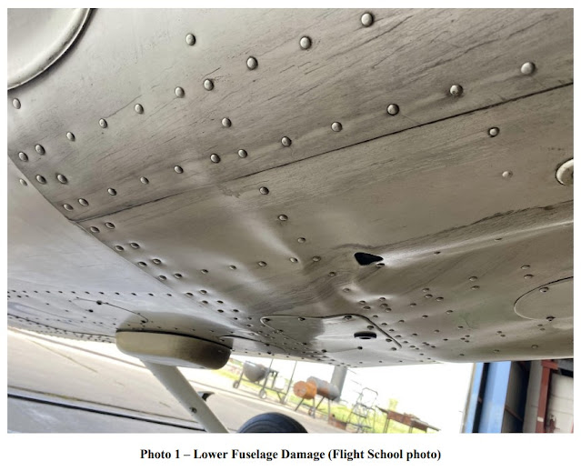
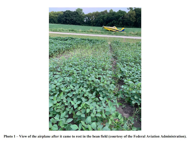
The commercial pilot reported that before the aerial application flight, he added Jet A fuel to both wing tanks for a total of 150 gallons of fuel onboard. While flying low-level over a field on the third load, the pilot noticed a change in engine power. He maneuvered the airplane out of the field and the engine steadily lost power. The pilot tried to advance the power forward with no change and the airspeed and altitude decreased. The pilot performed a forced landing to a bean field. During the landing, the airplane bounced, slid across a road, and then came to rest upright. The airplane sustained substantial damage to the fuselage and the right wing.

The property owner of the bean field reported that he helped the pilot add about 9 gallons of red die automotive diesel fuel to the left fuel tank and about 5 gallons of the fuel to the right fuel tank after the accident. The pilot reported that the low fuel warning light illuminated about five minutes before the partial loss of engine power, yet the pilot continued with the low-level aerial application maneuvers. When the low fuel warning light illuminates, the airplane flight manual states to, “fly straight and level and monitor fuel gauges” and “land as soon as practical.” The operator reported that there were no preimpact mechanical malfunctions or
failures with the airframe and engine that would have precluded normal operation.

Probable Cause and Findings

The National Transportation Safety Board determines the probable cause(s) of this accident to be:
The pilot’s decision to continue low-level aerial application flight maneuvers after the low fuel warning light illuminated, which resulted in a partial loss of engine power due to fuel exhaustion.

Findings

Aircraft Fuel - Fluid management
Aircraft (general) - Incorrect use/operation
Personnel issues Use of equip/system - Pilot
Personnel issues Decision making/judgment - Pilot

Factual Information

History of Flight

Maneuvering-low-alt flying Fuel related
Maneuvering-low-alt flying Fuel exhaustion (Defining event)
Maneuvering-low-alt flying Loss of engine power (partial)
Maneuvering-low-alt flying Attempted remediation/recovery
Landing Off-field or emergency landing
Landing Collision during takeoff/land

Pilot Information

Certificate: Commercial 
Age: 25, Male
Airplane Rating(s): Single-engine land; Single-engine sea
Seat Occupied: Single
Other Aircraft Rating(s): None
Restraint Used: 4-point
Instrument Rating(s): Airplane
Second Pilot Present: No
Instructor Rating(s): None 
Toxicology Performed:
Medical Certification:  Class 2 Without waivers/limitations
Last FAA Medical Exam: March 8, 2021
Occupational Pilot: Yes 
Last Flight Review or Equivalent: June 5, 2021
Flight Time: (Estimated) 2470.7 hours (Total, all aircraft), 473 hours (Total, this make and model), 2452.9 hours (Pilot In Command, all aircraft), 563.3 hours (Last 90 days, all aircraft), 314.2 hours (Last 30 days, all aircraft), 11.5 hours (Last 24 hours, all aircraft)

Aircraft and Owner/Operator Information

Aircraft Make: AIR TRACTOR INC 
Registration: N502CP
Model/Series: AT-502B
Aircraft Category: Airplane
Year of Manufacture: 2008
Amateur Built:
Airworthiness Certificate: Restricted (Special) 
Serial Number: 502B2632
Landing Gear Type: Tailwheel 
Seats: 1
Date/Type of Last Inspection: June 1, 2021 Annual
Certified Max Gross Wt.: 8000 lbs
Time Since Last Inspection: 
Engines: 1 Turbo prop
Airframe Total Time: 4648.1 Hrs as of last inspection
Engine Manufacturer: Pratt & Whitney Canada
ELT: Not installed 
Engine Model/Series: PT6A-34AG
Registered Owner:
Rated Power: 750 Horsepower
Operator:
Operating Certificate(s) Held: Agricultural aircraft (137)
Operator Does Business As: McElwain Sprayers, LLC 
Operator Designator Code: WCFG

Meteorological Information and Flight Plan

Conditions at Accident Site: Visual (VMC)
Condition of Light: Day
Observation Facility, Elevation: KTOP,885 ft msl 
Distance from Accident Site: 11 Nautical Miles
Observation Time: 08:53 Local
Direction from Accident Site: 140°
Lowest Cloud Condition: Clear 
Visibility:  9 miles
Lowest Ceiling: None
Visibility (RVR):
Wind Speed/Gusts: 5 knots / 
Turbulence Type Forecast/Actual: None / None
Wind Direction: 80° 
Turbulence Severity Forecast/Actual: N/A / N/A
Altimeter Setting: 30.03 inches Hg
Temperature/Dew Point: 22°C / 18°C
Precipitation and Obscuration: No Obscuration; No Precipitation
Departure Point: Atchison, KS (K59) 
Type of Flight Plan Filed: None
Destination: Wamego, KS (69K) 
Type of Clearance: None
Departure Time: 07:04 Local 
Type of Airspace: Class G

Wreckage and Impact Information

Crew Injuries: 1 None 
Aircraft Damage: Substantial
Passenger Injuries:
Aircraft Fire: None
Ground Injuries: 
Aircraft Explosion: None
Total Injuries: 1 None 
Latitude, Longitude: 39.216972,-95.76119(est)

Low Altitude Operation/Event: Robinson R44, N775AK; accident occurred August 04, 2021 in Waukon, Allamakee County, Iowa


Aviation Accident Final Report - National Transportation Safety Board

The National Transportation Safety Board did not travel to the scene of this accident.

Additional Participating Entity:
Federal Aviation Administration / Flight Standards District Office; Ankeny, Iowa

Investigation Docket - National Transportation Safety Board:


Location: Waukon, Iowa 
Accident Number: CEN21LA350
Date and Time: August 4, 2021, 08:15 Local
Registration: N775AK
Aircraft: ROBINSON HELICOPTER R44 
Aircraft Damage: Substantial
Defining Event: Low altitude operation/event 
Injuries: 1 Minor
Flight Conducted Under: Part 137: Agricultural

Analysis

The pilot was conducting an agricultural application pass when the helicopter struck a powerline crossing the cornfield being sprayed. He did not see the line until exiting the helicopter after the accident. Earlier in the morning he had surveyed the area for obstacles but did not observe any lines crossing the field. The pilot commented that his initial survey pass was completed toward the east with the sun “low in the sky and in [his] eyes.” He noted that there were no issues with the helicopter before contacting with the power line. The helicopter sustained substantial damage to the main rotor system, the fuselage, and the empennage.

Probable Cause and Findings

The National Transportation Safety Board determines the probable cause(s) of this accident to be:
The pilot’s failure to maintain adequate clearance from a powerline during an agricultural application pass.

Findings

Environmental issues Wire - Awareness of condition
Aircraft Altitude - Not attained/maintained
Personnel issues Monitoring environment - Pilot

Factual Information

History of Flight

Maneuvering-low-alt flying Low altitude operation/event (Defining event)

Pilot Information

Certificate: Commercial 
Age: 66, Male
Airplane Rating(s): Single-engine land; Single-engine sea
Seat Occupied: Right
Other Aircraft Rating(s): Helicopter 
Restraint Used: 3-point
Instrument Rating(s): Airplane 
Second Pilot Present: No
Instructor Rating(s): None 
Toxicology Performed:
Medical Certification: Class 2 With waivers/limitations 
Last FAA Medical Exam: September 24, 2020
Occupational Pilot: Yes 
Last Flight Review or Equivalent: March 15, 2021
Flight Time: 27652 hours (Total, all aircraft), 3015 hours (Total, this make and model)

Aircraft and Owner/Operator Information

Aircraft Make: ROBINSON HELICOPTER
Registration: N775AK
Model/Series: R44 
Aircraft Category: Helicopter
Year of Manufacture: 2008
Amateur Built:
Airworthiness Certificate: Restricted (Special) 
Serial Number: 1875
Landing Gear Type: Skid 
Seats: 4
Date/Type of Last Inspection: March 10, 2021 Annual 
Certified Max Gross Wt.: 2400 lbs
Time Since Last Inspection: 187.9 Hrs
Engines: 1 Reciprocating
Airframe Total Time: 1973.5 Hrs at time of accident
Engine Manufacturer: Lycoming
ELT: Not installed 
Engine Model/Series: O-540-F1B5
Registered Owner:
Rated Power: 260 Horsepower
Operator: 
Operating Certificate(s) Held: Agricultural aircraft (137)

Meteorological Information and Flight Plan

Conditions at Accident Site: Visual (VMC)
Condition of Light: Day
Observation Facility, Elevation: DEH,1158 ft msl 
Distance from Accident Site: 16 Nautical Miles
Observation Time: 07:55 Local 
Direction from Accident Site: 273°
Lowest Cloud Condition: Clear
Visibility: 7 miles
Lowest Ceiling: None
Visibility (RVR):
Wind Speed/Gusts: 0 knots / 0 knots 
Turbulence Type Forecast/Actual:  /
Wind Direction: 
Turbulence Severity Forecast/Actual:  /
Altimeter Setting: 30.14 inches Hg 
Temperature/Dew Point: 16°C / 16°C
Precipitation and Obscuration: No Obscuration; No Precipitation
Departure Point:
Type of Flight Plan Filed: None
Destination: Waukon, IA
Type of Clearance: None
Departure Time: 
Type of Airspace: Class G

Wreckage and Impact Information

Crew Injuries: 1 Minor
Aircraft Damage: Substantial
Passenger Injuries: N/A
Aircraft Fire: None
Ground Injuries: N/A 
Aircraft Explosion: None
Total Injuries: 1 Minor
Latitude, Longitude: 43.261185,-91.375664