Friday, December 10, 2021

Ultralight: Accident occurred December 09, 2021 in Hutchinson, Reno County, Kansas


PARTRIDGE, Kansas — Reno County emergency units and authorities were called to the scene of an ultralight plane crash Thursday. The pilot escaped serious injury, though he was taken to the hospital to be checked out.

The KHP's report puts the time of the crash at 4:37 p.m. 

According to that report, 43-year-old Scott M. Bontrager was westbound and going to land on Morgan Road when he did not see power lines and struck them.

The ultralight was down in a field approximately 60 yards southwest of the corner of Morgan Road and Partridge Road in rural Reno County.

Electric crews spent into the evening on scene to repair the downed power lines. The lines down caused the closure of Morgan Road east of Partridge until the repairs were complete.

Rural fire districts three and four were called out as well as EMS.


PARTRIDGE, Kansas (WIBW) - The pilot of an ultralight plane escaped serious injury when the aircraft crashed late Thursday afternoon in Reno County, authorities said.

The crash was reported at 4:37 p.m. at W. Partridge Road and S. Morgan Avenue. The location was about two miles north of Partridge and 12 miles southwest of Hutchinson.

According to the Kansas Highway Patrol, a Kolb Firefly ultra-light plane was westbound and preparing to land on Morgan Road at the time of the crash.

The pilot didn’t see power lines and the plane struck them. The plane then came to rest on the southwest corner of W. Partridge Road and S. Morgan Avenue.

The pilot, Scott M. Bontrager, 43, of Hutchinson, was transported to Hutchinson Regional Hospital for treatment of possible injuries.

The patrol said Bontrager, who was alone in the plane, was wearing his safety restraint.

Cessna 177 Cardinal, N3388T: Accident occurred October 16, 2021 in White Swan, Yakima County, Washington


This is preliminary information, subject to change, and may contain errors. Any errors in this report will be corrected when the final report has been completed.

The National Transportation Safety Board did not travel to the scene of this accident.

Additional Participating Entity: 
Federal Aviation Administration / Flight Standards District Office; Spokane, Washington 

Investigation Docket - National Transportation Safety Board:


Location: White Swan, WA
Accident Number: WPR22LA017
Date & Time: October 16, 2021, 14:30 Local
Registration: N3388T
Aircraft: Cessna 177 
Injuries: 1 None
Flight Conducted Under: Part 91: General aviation - Personal

Aircraft and Owner/Operator Information

Aircraft Make: Cessna 
Registration: N3388T
Model/Series: 177 
Aircraft Category: Airplane
Amateur Built:
Operator: 
Operating Certificate(s) Held: None
Operator Designator Code:

Meteorological Information and Flight Plan

Conditions at Accident Site: 
Condition of Light:
Observation Facility, Elevation: KOMK,1300 ft msl 
Observation Time: 14:53 Local
Distance from Accident Site: 28 Nautical Miles 
Temperature/Dew Point: 18°C /4°C
Lowest Cloud Condition: Clear
Wind Speed/Gusts, Direction: 11 knots / , 200°
Lowest Ceiling: None
Visibility: 10 miles
Altimeter Setting: 29.95 inches Hg 
Type of Flight Plan Filed:
Departure Point: 
Destination:

Wreckage and Impact Information

Crew Injuries: 1 None 
Aircraft Damage: Substantial
Passenger Injuries: 
Aircraft Fire: None
Ground Injuries: 
Aircraft Explosion: In-flight
Total Injuries: 1 None
Latitude, Longitude: 46.367694,-120.80904 (est)

CubCrafters CCX-2300 Carbon Cub, N24PK: Accident occurred November 04, 2021 at Taos Regional Airport (KSKX), New Mexico


This is preliminary information, subject to change, and may contain errors. Any errors in this report will be corrected when the final report has been completed. 

The National Transportation Safety Board did not travel to the scene of this accident. 

Additional Participating Entity:
Federal Aviation Administration / Flight Standards District Office; Albuquerque, New Mexico

Investigation Docket - National Transportation Safety Board:

Santa Fe Aircraft LLC


Location: Taos, New Mexico
Accident Number: WPR22LA027
Date and Time: November 4, 2021, 12:00 Local 
Registration: N24PK
Aircraft: SANTA FE AIRCRAFT LLC
CCX-2300 Injuries: 2 None
Flight Conducted Under: Part 91: General aviation - Personal

Aircraft and Owner/Operator Information

Aircraft Make: SANTA FE AIRCRAFT LLC 
Registration: N24PK
Model/Series: CCX-2300 
Aircraft Category: Airplane
Amateur Built:
Operator: On file
Operating Certificate(s) Held: None
Operator Designator Code:

Meteorological Information and Flight Plan

Conditions at Accident Site: VMC
Condition of Light: Day
Observation Facility, Elevation: KSKX,7091 ft msl 
Observation Time: 13:56 Local
Distance from Accident Site: 0 Nautical Miles
Temperature/Dew Point: 14°C /-4°C
Lowest Cloud Condition: Clear 
Wind Speed/Gusts, Direction: / ,
Lowest Ceiling: None 
Visibility: 10 miles
Altimeter Setting: 30.25 inches Hg
Type of Flight Plan Filed: None
Departure Point: Taos, NM 
Destination: Taos, NM

Wreckage and Impact Information

Crew Injuries: 1 None
Aircraft Damage: Substantial
Passenger Injuries: 1 None
Aircraft Fire: None
Ground Injuries: 
Aircraft Explosion: None
Total Injuries: 2 None
Latitude, Longitude: 36.451694,-105.67308

Cessna 172 Skyhawk, N8509B: Accident occurred November 14, 2021 in Stanley, Custer County, Idaho


This is preliminary information, subject to change, and may contain errors. Any errors in this report will be corrected when the final report has been completed.

The National Transportation Safety Board did not travel to the scene of this accident.

Additional Participating Entity: 
Federal Aviation Administration / Flight Standards District Office; Boise, Idaho

Investigation Docket - National Transportation Safety Board:


Location: Stanley, Idaho
Accident Number: WPR22LA037
Date and Time: November 14, 2021, 13:30 Local
Registration: N8509B
Aircraft: Cessna 172 
Injuries: 2 Minor
Flight Conducted Under: Part 91: General aviation - Personal

Aircraft and Owner/Operator Information

Aircraft Make: Cessna 
Registration: N8509B
Model/Series: 172 
Aircraft Category: Airplane
Amateur Built:
Operator: 
Operating Certificate(s) Held: None
Operator Designator Code:

Meteorological Information and Flight Plan

Conditions at Accident Site: VMC
Condition of Light: Day
Observation Facility, Elevation: KSNT,6495 ft msl
Observation Time: 11:51 Local
Distance from Accident Site: 33 Nautical Miles
Temperature/Dew Point: 12°C /2°C
Lowest Cloud Condition: Clear
Wind Speed/Gusts, Direction: / 25 knots,
Lowest Ceiling:
Visibility:
Altimeter Setting: 30.27 inches Hg
Type of Flight Plan Filed: None
Departure Point: Stanley, ID
Destination: Garden Valley, ID (U88)

Wreckage and Impact Information

Crew Injuries: 1 Minor
Aircraft Damage: Substantial
Passenger Injuries: 1 Minor 
Aircraft Fire: None
Ground Injuries:
Aircraft Explosion: None
Total Injuries: 2 Minor 
Latitude, Longitude: 44.723306,-115.00397 (est)

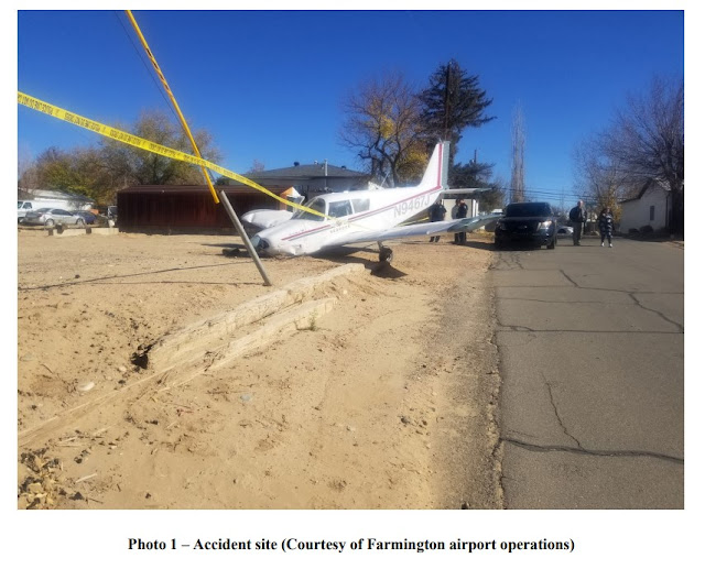
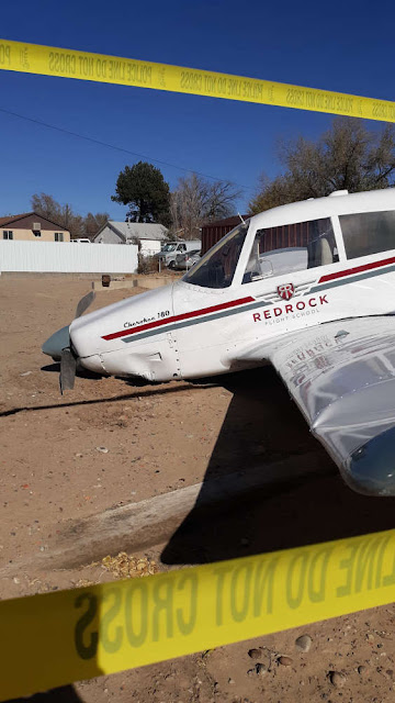
Piper PA-28-180 Cherokee, N9467J: Accident occurred November 17, 2021 and Incident September 13, 2020


This is preliminary information, subject to change, and may contain errors. Any errors in this report will be corrected when the final report has been completed. 

The National Transportation Safety Board did not travel to the scene of this accident. 

Additional Participating Entity:
Federal Aviation Administration / Flight Standards District Office; Albuquerque, New Mexico

Investigation Docket - National Transportation Safety Board:

Red Rock Flying School LLC


Location: Farmington, New Mexico
Accident Number: WPR22LA041
Date and Time: November 17, 2021, 10:44 Local 
Registration: N9467J
Aircraft: Piper PA-28-180 
Injuries: 1 Minor
Flight Conducted Under: Part 91: General aviation - Personal

Aircraft and Owner/Operator Information

Aircraft Make: Piper 
Registration: N9467J
Model/Series: PA-28-180 
Aircraft Category: Airplane
Amateur Built:
Operator:
Operating Certificate(s) Held: None
Operator Designator Code:

Meteorological Information and Flight Plan

Conditions at Accident Site: VMC
Condition of Light: Day
Observation Facility, Elevation: KFMN,5502 ft msl
Observation Time: 10:53 Local
Distance from Accident Site: 0 Nautical Miles
Temperature/Dew Point: 9°C /-8°C
Lowest Cloud Condition: Clear 
Wind Speed/Gusts, Direction: 10 knots / , 270°
Lowest Ceiling: None 
Visibility: 10 miles
Altimeter Setting: 30.15 inches Hg 
Type of Flight Plan Filed: None
Departure Point: Mesa, AZ (FFZ) 
Destination: Farmington, NM

Wreckage and Impact Information

Crew Injuries: 1 Minor
Aircraft Damage: Unknown
Passenger Injuries: 
Aircraft Fire: None
Ground Injuries: 
Aircraft Explosion: None
Total Injuries: 1 Minor
Latitude, Longitude: 36.738851,-108.20743 

November 17, 2021

November 17, 2021

November 17, 2021
~


Federal Aviation Administration / Flight Standards District Office; Scottsdale, Arizona

September 13, 2020:  Aircraft landed and veered off runway incurring a propeller strike at Falcon Field Airport (KFFZ), Mesa, Arizona.

Red Rock Flying School LLC


Date: 13-SEP-20
Time: 20:20:00Z
Regis#: N9467J
Aircraft Make: PIPER
Aircraft Model: PA28
Event Type: INCIDENT
Highest Injury: NONE
Aircraft Missing: No
Damage: MINOR
Activity: INSTRUCTION
Flight Phase: LANDING (LDG)
Operation: 91
City: MESA
State: ARIZONA

Mooney M20C, N4109N: Incident occurred December 09, 2021 at Litchfield Municipal Airport (KLJF), Montgomery County, Illinois

Federal Aviation Administration / Flight Standards District Office; Minneapolis, Minnesota

Aircraft landed gear up.  


Date: 09-DEC-21
Time: 17:58:00Z
Regis#: N4109N
Aircraft Make: MOONEY
Aircraft Model: M20C
Event Type: INCIDENT
Highest Injury: NONE
Aircraft Missing: No
Damage: UNKNOWN
Activity: PERSONAL
Flight Phase: LANDING (LDG)
Operation: 91
City: LITCHFIELD
State: MINNESOTA

Learjet 35A, N46MF: Incident occurred December 10, 2021 at Grants-Milan Municipal Airport (KGNT), Cibola County, New Mexico

Federal Aviation Administration / Flight Standards District Office; Albuquerque, New Mexico

Aircraft landed and went off end of the runway. 

Med Flight Air Ambulance Inc


Date: 10-DEC-21
Time: 03:30:00Z
Regis#: N46MF
Aircraft Make: LEARJET
Aircraft Model: 35
Event Type: INCIDENT
Highest Injury: NONE
Aircraft Missing: No
Damage: UNKNOWN
Activity: AMBULANCE
Flight Phase: LANDING (LDG)
Operation: 135
Aircraft Operator: MED FLIGHT AIR AMBULANCE
City: GRANTS
State: NEW MEXICO

Piper PA-22-135 Tri-Pacer, N3372A: Accident occurred December 08, 2021 at Tahlequah Municipal Airport (KTQH), Cherokee County, Oklahoma


This is preliminary information, subject to change, and may contain errors. Any errors in this report will be corrected when the final report has been completed. 

The National Transportation Safety Board did not travel to the scene of this accident. 

Additional Participating Entity: 
Federal Aviation Administration / Flight Standards District Office; Oklahoma City, Oklahoma

Investigation Docket - National Transportation Safety Board:


Location: Tahlequah, Oklahoma
Accident Number: CEN22LA066
Date and Time: December 8, 2021, 12:00 Local 
Registration: N3372A
Aircraft: Piper PA-22-135 
Injuries:
Flight Conducted Under: Part 91: General aviation - Unknown

Aircraft and Owner/Operator Information

Aircraft Make: Piper
Registration: N3372A
Model/Series: PA-22-135
Aircraft Category: Airplane
Amateur Built:
Operator: On file
Operating Certificate(s) Held: None
Operator Designator Code: None

Meteorological Information and Flight Plan

Conditions at Accident Site: VMC 
Condition of Light: Day
Observation Facility, Elevation: KTQH,873 ft msl
Observation Time: 11:55 Local
Distance from Accident Site: 0 Nautical Miles
Temperature/Dew Point: 13°C /-2°C
Lowest Cloud Condition: Clear 
Wind Speed/Gusts, Direction: / ,
Lowest Ceiling: None 
Visibility: 10 miles
Altimeter Setting: 30.06 inches Hg
Type of Flight Plan Filed: None
Departure Point: 
Destination:

Wreckage and Impact Information

Crew Injuries: 
Aircraft Damage: Substantial
Passenger Injuries:
Aircraft Fire: None
Ground Injuries: 
Aircraft Explosion: None
Total Injuries: 
Latitude, Longitude: 35.930278,-95.004528 (est)


Airport officials deemed a plane crash at the Tahlequah Municipal Airport to be suspicious and “bizarre.” 

Acting Airport Manager Greg Blish said the crashed aircraft was located in an obscure area with heavy brush on Wednesday, December 8. 

“It’s kind of a bizarre story, really,” said Blish. “It was a Piper PA-22-135 Tri-Pacer and there’s no pilot or passengers located, but there's substantial damage done to the aircraft.” 

Blish believed the aircraft ran out of fuel but he’s unsure when the crash occurred. 

“I had three or four planes flying this morning and nobody noticed it until a gentleman [who] flies out of the Tahlequah Municipal Airport saw it and called about 1:15 p.m., or so,” said Blish. 

Tahlequah Police Department, Tahlequah Fire Department, Emergency Management, the Oklahoma Highway Patrol, and the Federal Aviation Administration all responded to the crash site. Blish said they are still investigating. 

“I put the word out to search the area and they didn’t locate anybody. My investigation in the aircraft showed no visual signs of injury,” he said. 

The registered owner was contacted and he advised the plane was sold in August to an auction company. 

“Right now, I’ve got people trying to run down who the auction company sold it to. According to Federal Aviation Administration records, it doesn’t show to be legally licensed as far as the registration,” said Blish.

Cessna P210N Pressurized Centurion, N152BT: Accident occurred December 09, 2021 near Twin Oaks Airpark (7S3), Hillsboro, Washington County, Oregon

National Transportation Safety Board accident number: WPR22LA060 

Federal Aviation Administration / Flight Standards District Office; Portland, Oregon

Aircraft experienced engine issues and crashed in a nut orchard.  

COHO Aviation LLC


Date: 09-DEC-21
Time: 23:44:00Z
Regis#: N152BT
Aircraft Make: CESSNA
Aircraft Model: 210
Event Type: ACCIDENT
Highest Injury: NONE
Aircraft Missing: No
Damage: SUBSTANTIAL
Activity: PERSONAL
Flight Phase: EN ROUTE (ENR)
Operation: 91
City: HILLSBORO
State: OREGON

Cessna 182T Skylane, N528CP: Incident occurred December 09, 2021 in San Juan, Puerto Rico

Federal Aviation Administration / Flight Standards District Office; San Juan, Puerto Rico

Aircraft landed and hit the tail on the runway.  

Civil Air Patrol


Date: 09-DEC-21
Time: 18:54:00Z
Regis#: N528CP
Aircraft Make: CESSNA
Aircraft Model: 172
Event Type: INCIDENT
Highest Injury: NONE
Aircraft Missing: No
Damage: MINOR
Activity: PERSONAL
Flight Phase: LANDING (LDG)
Operation: 91
City: SAN JUAN
State: PUERTO RICO

Piper PA-28-180 Cherokee, N7157W: Accident occurred December 09, 2021 at Ralph M Hall / Rockwall Municipal Airport (F46), Rockwall County, Texas


This is preliminary information, subject to change, and may contain errors. Any errors in this report will be corrected when the final report has been completed. 

The National Transportation Safety Board did not travel to the scene of this accident. 

Additional Participating Entity:
Federal Aviation Administration / Flight Standards District Office; Irving, Texas

Investigation Docket - National Transportation Safety Board:

MMM Friemel Inc


Location: Rockwall, Texas
Accident Number: CEN22LA075
Date and Time: December 9, 2021, 14:28 Local
Registration: N7157W
Aircraft: Piper PA-28-180
Injuries: 1 Minor, 2 None
Flight Conducted Under: Part 91: General aviation - Personal

Aircraft and Owner/Operator Information

Aircraft Make: Piper 
Registration: N7157W
Model/Series: PA-28-180
Aircraft Category: Airplane
Amateur Built:
Operator: 
Operating Certificate(s) Held: None
Operator Designator Code:

Meteorological Information and Flight Plan

Conditions at Accident Site: VMC
Condition of Light: Day
Observation Facility, Elevation: KF46,575 ft msl
Observation Time: 14:35 Local
Distance from Accident Site: 0 Nautical Miles 
Temperature/Dew Point: 25°C /15°C
Lowest Cloud Condition: Clear 
Wind Speed/Gusts, Direction: 11 knots / 15 knots, 230°
Lowest Ceiling: None
Visibility: 10 miles
Altimeter Setting: 29.79 inches Hg 
Type of Flight Plan Filed:
Departure Point: Amarillo, TX (AMA) 
Destination: Rockwall, TX (F46)

Wreckage and Impact Information

Crew Injuries: 1 Minor 
Aircraft Damage: Substantial
Passenger Injuries: 2 None
Aircraft Fire: None
Ground Injuries:
Aircraft Explosion: None
Total Injuries: 1 Minor, 2 None 
Latitude, Longitude: 32.930594,-96.435486 (est)


CHR International Safari 400, N401TB: Accident occurred December 09, 2021 at McKinney National Airport (KTKI), Collin County, Texas


This is preliminary information, subject to change, and may contain errors. Any errors in this report will be corrected when the final report has been completed. 

The National Transportation Safety Board did not travel to the scene of this accident. 

Additional Participating Entity:
Federal Aviation Administration / Flight Standards District Office; Irving, Texas

Investigation Docket - National Transportation Safety Board:


Location: McKinney, Texas
Accident Number: CEN22LA068
Date and Time: December 9, 2021, 17:15 Local
Registration: N401TB
Aircraft: CHR International Safari 400
Injuries: 1 Serious
Flight Conducted Under: Part 91: General aviation - Personal

Aircraft and Owner/Operator Information

Aircraft Make: CHR International 
Registration: N401TB
Model/Series: Safari 400
Aircraft Category: Helicopter
Amateur Built: Yes
Operator: On file
Operating Certificate(s) Held: None
Operator Designator Code:

Meteorological Information and Flight Plan

Conditions at Accident Site: 
Condition of Light:
Observation Facility, Elevation: KTKI,586 ft msl 
Observation Time: 16:53 Local
Distance from Accident Site: 1 Nautical Miles
Temperature/Dew Point: 24°C /11°C
Lowest Cloud Condition: Clear 
Wind Speed/Gusts, Direction: 7 knots / , 200°
Lowest Ceiling: None
Visibility: 10 miles
Altimeter Setting: 29.77 inches Hg
Type of Flight Plan Filed:
Departure Point: 
Destination:

Wreckage and Impact Information

Crew Injuries: 1 Serious 
Aircraft Damage: Substantial
Passenger Injuries: 
Aircraft Fire: On-ground
Ground Injuries:
Aircraft Explosion: Unknown
Total Injuries: 1 Serious 
Latitude, Longitude: 33.177391,-96.591032 (est)


Piper PA-28-140 Cherokee, N3865K: Fatal accident occurred December 08, 2021 near West Houston Airport (KIWS), Harris County, Texas

This is preliminary information, subject to change, and may contain errors. Any errors in this report will be corrected when the final report has been completed. 

The National Transportation Safety Board traveled to the scene of this accident. 

Additional Participating Entities:
Federal Aviation Administration / Flight Standards District Office; Houston, Texas
Piper Aircraft; Vero Beach, Florida
Lycoming; Williamsport, Pennsylvania


Location: Houston, Texas
Accident Number: CEN22FA067
Date and Time: December 8, 2021, 19:57 Local
Registration: N3865K
Aircraft: Piper Aircraft PA 28-140
Injuries: 2 Fatal
Flight Conducted Under: Part 91: General aviation - Personal

On December 8, 2021, about 1957 central standard time, a Piper PA 28-140 airplane, N3865K, was destroyed when it was involved in an accident near Houston, Texas. The student pilot and passenger were fatally injured. The airplane was operated as a Title 14 Code of Federal Regulations Part 91 personal flight.

There were no witnesses to the accident. Radar indicated the airplane departed the West Houston Airport (IWS) about 1955 and proceeded generally south-southwest. About 1.5 miles later the track showed a slight descending left turn and the groundspeed of the airplane increased. The airplane then made a slight right turn; during which, the airplane climbed and the groundspeed decreased. The airplane then made a tight left descending turn followed immediately by a hard right descending turn. The airplane descent increased before it went off radar.

The airplane was found the next day about 2.5 miles south of the airport in a heavily wooded area. The debris path was about 50 ft long on a heading of 320°. The first identified points of impact were a few topped trees, followed by a portion of the outboard right wing. Several more trees were topped descending toward a large impact crater in the soft dirt. The airplane came to rest nose down just beyond the crater; it was the last major piece of debris.

On the day of the accident, the sunset at 1723, and civil twilight ended at 1749. About the time of the accident, the sun was greater than 32° below the horizon, and the moon was about 24° above the horizon. The phase of the moon was a waxing crescent with 29% of the moon’s disk illuminated.

Satellite imagery indicated an area of low stratus and/or fog in the vicinity of the accident site. The national weather service had also issued an AIRMET for instrument flight rules conditions over the Houston area, due to visibility below 3 miles, mist, and fog. 

Aircraft and Owner/Operator Information

Aircraft Make: Piper Aircraft
Registration: N3865K
Model/Series: PA 28-140
Aircraft Category: Airplane
Amateur Built:
Operator:
Operating Certificate(s) Held: None
Operator Designator Code:

Meteorological Information and Flight Plan

Conditions at Accident Site: IMC
Condition of Light: NightDark
Observation Facility, Elevation: KSGR,84 ft msl 
Observation Time: 19:53 Local
Distance from Accident Site: 9 Nautical Miles
Temperature/Dew Point: 19°C /16°C
Lowest Cloud Condition: Clear 
Wind Speed/Gusts, Direction: 10 knots / , 130°
Lowest Ceiling: Overcast / 800 ft AGL 
Visibility: 8 miles
Altimeter Setting: 3000 inches Hg
Type of Flight Plan Filed: None
Departure Point: Houston, TX
Destination: Pearland, TX (LVJ)

Wreckage and Impact Information

Crew Injuries: 1 Fatal 
Aircraft Damage: Destroyed
Passenger Injuries: 1 Fatal
Aircraft Fire: None
Ground Injuries:
Aircraft Explosion: None
Total Injuries: 2 Fatal 
Latitude, Longitude: 29.778,-95.673 

Those who may have information that might be relevant to the National Transportation Safety Board (NTSB) investigation may contact them by email witness@ntsb.gov, and any friends and family who want to contact investigators about the accident should email assistance@ntsb.gov. You can also call the NTSB Response Operations Center at 844-373-9922 or 202-314-6290.

The Flight School
July 30, 2021 
Congratulations to Solomon Babalola on his first solo today!
Location: Houston Executive Airport (KTME)
CFI: Andrew
~


HOUSTON – The Department of Public Safety has released the identities of the pilot and passenger killed in a plane crash near the Katy Freeway. The pilot has been identified as Katy resident Solomon Babalola, 23, and the female passenger was Apesin Oluwafunmilayo, 20. She resided in Houston.

DPS confirmed Thursday that the two died after a Piper PA-28-140 Cherokee crashed behind the Harris County Precinct 5 headquarters.

The  Piper PA-28-140 Cherokee was found deep inside George Bush Park near the 17400 block of the Katy Freeway shortly before 2 p.m.

The pilot and passenger were reported dead at the scene, Texas DPS officials said. The pilot was found ejected from the plane while the woman was still trapped inside, according to DPS.

During a news conference Thursday evening, the Texas DPS PIO, Richard Standifer, said the plane, which was headed to Pearland, departed around 7:55 p.m. on Wednesday.

Personnel at the  West Houston Airport told KPRC they last heard from the pilot just before take off but don’t normally stay in contact unless it’s requested.


HOUSTON, Texas  — Two people died after a small airplane crashed in a wooded area of west Harris County, according to the Texas Department of Public Safety.

Wreckage from a Piper PA-28-140 Cherokee was located Thursday in a wooded area south of the Barker Dam near the Katy Freeway.

During a DPS news conference Thursday night, we learned the plane took off from the West Houston Airport around 7:30 Wednesday night, heading for Pearland.

The pilot's girlfriend went to the airport Thursday trying to find out what happened.

“The airport personnel went up to look for them. They appeared to find what they thought was debris and local law enforcement was brought out here,” DPS Sgt. Richard Standifer said. 

He said the man was ejected from the plane. The second victim, believed to be a woman, was still in the fuselage and had to be extracted.

“I’m here to tell you the brush is heavy back there, they had to bring in dozers and chainsaws and cut their way through it. So the only way that you’d be able to see that thing is if it caught on fire, and I don’t see any evidence of it catching on fire to me.”

As for the people on board, police found a Houston ID on one of them, but say the plane -- which was recently bought -- was registered out of Rogers, Arkansas. 

The National Transportation Safety Board is investigating the incident.

A manager at the West Houston Airport nearby told KHOU the aircraft involved had taken off from its facility just before 8 p.m. Wednesday and didn't return.

The airport is approximately two miles north of the crash site.

The aircraft's transponder wasn't working properly, according to the manager, and airport personnel was not aware the plane had gone missing until the girlfriend of one of the victims came to the airport looking for them on Thursday.

The plane was found a short time later, he said.

https://www.khou.com