Sunday, February 05, 2023

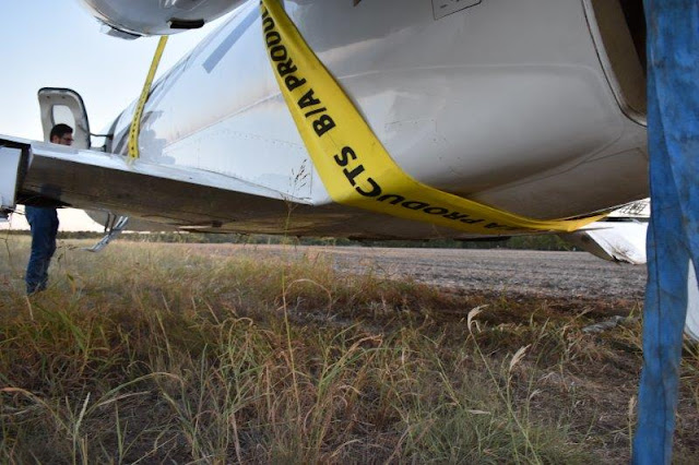
Czech Sportcruiser, N823MM: Accident occurred March 24, 2022 near Lanark, New Mexico

This is preliminary information, subject to change, and may contain errors. Any errors in this report will be corrected when the final report has been completed. 

Investigator In Charge (IIC): Baker, Daniel

The National Transportation Safety Board did not travel to the scene of this accident.

Additional Participating Entity: 
Joseph Kluk; Federal Aviation Administration / Flight Standards District Office; Albuquerque, New Mexico 


Location: Lanark, New Mexico
Accident Number: WPR22LA137
Date and Time: March 24, 2022, 18:45 Local
Registration: N823MM
Aircraft: CZECH SPORT AIRCRAFT A S SPORTCRUISER 
Injuries: 1 Minor
Flight Conducted Under: Part 91: General aviation - Personal

On March 24, 2022, at 1845 mountain daylight time, a Czech Sport Aircraft Sportcruiser airplane, N823MM, was substantially damaged when it was involved in an accident near Lanark, New Mexico. The pilot received minor injuries. The airplane was as operated as a Title 14 Code of Federal Regulations (CFR) Part 91 personal flight.

According to the pilot, the purpose of the flight was to calibrate a new angle-of-attack (AOA) gauge that had been recently installed in the airplane. He had climbed to 6,500 ft mean sea level (msl) and performed a power off stall. As the nose of the airplane dropped the left canopy latch “let loose.” About 4-5 seconds later the right canopy latch “let go” and the whole windscreen “popped up like a speed brake.” The nose of the airplane remained pitched down and the airplane impacted terrain. The airplane sustained substantial damage to the left wing and fuselage.

Aircraft and Owner/Operator Information

Aircraft Make: CZECH SPORT AIRCRAFT A S
Registration: N823MM
Model/Series: SPORTCRUISER 
Aircraft Category: Airplane
Amateur Built:
Operator: On file 
Operating Certificate(s) Held: None
Operator Designator Code:

Meteorological Information and Flight Plan

Conditions at Accident Site: 
Condition of Light:
Observation Facility, Elevation: 
Observation Time:
Distance from Accident Site:
Temperature/Dew Point:
Lowest Cloud Condition: 
Wind Speed/Gusts, Direction: / ,
Lowest Ceiling: 
Visibility:
Altimeter Setting: 
Type of Flight Plan Filed:
Departure Point:
Destination:

Wreckage and Impact Information

Crew Injuries: 1 Minor 
Aircraft Damage: Substantial
Passenger Injuries: 
Aircraft Fire: None
Ground Injuries: 
Aircraft Explosion: None
Total Injuries: 1 Minor
Latitude, Longitude: 31.984112,-106.80973 (est)

March 24, 2022:  Aircraft canopy popped open during flight causing aircraft to crash. 

Date: 25-MAR-22
Time: 00:43:00Z
Regis#: N823MM
Aircraft Make: SPORTCRUISER
Aircraft Model: SPORTCRUISER
Event Type: INCIDENT
Highest Injury: NONE
Aircraft Missing: No
Damage: UNKNOWN
Activity: PERSONAL
Flight Phase: MANEUVERING (MNV)
Operation: 91
City: EL PASO
State: TEXAS

Saturday, February 04, 2023

Cirrus SR20 G3, N99EC: Fatal accident occurred January 24, 2023 near Indianapolis Executive Airport (KTYQ), Indiana

Shane Pennington, II
August 1, 2002 — January 24, 2023
~


Aviation Investigation Preliminary Report - National Transportation Safety Board

Investigator In Charge (IIC): Sauer, Aaron

The National Transportation Safety Board did not travel to the scene of this accident.

This is preliminary information, subject to change, and may contain errors. Any errors in this report will be corrected when the final report has been completed.

Additional Participating Entities:
Christopher Johnson; Federal Aviation Administration / Flight Standards District Office; Indianapolis, Indiana 
Cirrus Aircraft; Duluth, Minnesota 

99EC Holding LLC


Location: Indianapolis, Indiana
Accident Number: CEN23LA093
Date and Time: January 24, 2023, 15:39 Local 
Registration: N99EC
Aircraft: Cirrus SR20 
Injuries: 1 Fatal
Flight Conducted Under: Part 91: General aviation - Personal

On January 24, 2023, about 1539 eastern standard time, a Cirrus SR20 airplane, N99EC, was destroyed when it was involved in an accident near Indianapolis, Indiana. The pilot sustained fatal injuries. The airplane was being operated as a Code of Federal Regulations Part 91 personal flight.

According to automatic dependent surveillance-broadcast data (ADS-B), the airplane departed the Indianapolis Executive Airport, Indianapolis, Indiana, about 1526. After takeoff, the airplane turned left, climbed to about 1,000 ft above ground level, and continued to the southeast past downtown Indianapolis. South of downtown and near the end of the data, the airplane made a 360° left turn and began a rapid descent (see Figure 1.). A residential surveillance camera captured the impact sequence and showed the airplane impact in a nose and right-wing low attitude. There were no witnesses to the accident.

The airplane wreckage was located adjacent to a single railroad track and several residential homes. The initial impact point, which was consistent with the propeller, engine, forward fuselage, and both wings, was located about 20 ft from the main wreckage. The initial impact contained the propeller blades and fragmented sections of the forward fuselage. Fragmented sections of the fuselage, wings, and empennage were found in the debris forward of the main wreckage. The airplane damage was consistent with a high angle and high energy impact with terrain.

Postaccident examination of the airplane revealed no mechanical malfunctions that would have precluded normal operations.


Aircraft and Owner/Operator Information

Aircraft Make: Cirrus
Registration: N99EC
Model/Series: SR20
Aircraft Category: Airplane
Amateur Built:
Operator: On file
Operating Certificate(s) Held: None
Operator Designator Code:

Meteorological Information and Flight Plan

Conditions at Accident Site: VMC
Condition of Light: Day
Observation Facility, Elevation: KIND, 792 ft msl
Observation Time: 20:54 Local
Distance from Accident Site: 7 Nautical Miles
Temperature/Dew Point: 6°C /-2°C
Lowest Cloud Condition: Few / 3000 ft AGL
Wind Speed/Gusts, Direction: 3 knots / , 230°
Lowest Ceiling: Overcast / 25000 ft AGL
Visibility: 10 miles
Altimeter Setting: 30.14 inches Hg 
Type of Flight Plan Filed:
Departure Point: Indianapolis, IN
Destination: Indianapolis, IN

Wreckage and Impact Information

Crew Injuries: 1 Fatal
Aircraft Damage: Destroyed
Passenger Injuries: 
Aircraft Fire: None
Ground Injuries: 
Aircraft Explosion: None
Total Injuries: 1 Fatal 
Latitude, Longitude: 39.701295,-86.136893 (est)

Those who may have information that might be relevant to the National Transportation Safety Board (NTSB) investigation may contact them by email witness@ntsb.gov, and any friends and family who want to contact investigators about the accident should email assistance@ntsb.gov. You can also call the NTSB Response Operations Center at 844-373-9922 or 202-314-6290.


Shane Pennington, II, 20, Mooresville, passed away January 24, 2023. Shane was born August 1, 2002, in Mooresville, to Shane and Angela (Price) Pennington.

Shane grew up in Mooresville and graduated from Mooresville High School in 2020 and most recently from Vincennes University.  He was a licensed pilot and was working towards becoming a commercial pilot.  Shane was a gifted athlete and played in the Mooresville Youth baseball, basketball, and football programs.  He played basketball for the Mooresville Pioneers in high school and also was a high jumper.  Shane was a people person, often described as the life of the party, he was a great friend to many. He was usually the organizer of the parties and kept the friends together.  He loved fitness, working out, and taking care of himself.  Shane enjoyed traveling, experiencing new things, and made for an easy role model for his friends and family.  He had a special bond with his dog Sadie.  Shane’s memory will be forever cherished by his loving family and many friends. 

He was preceded in death by his maternal grandfather, Mark Price and aunt, Michelle Price.  

Survivors include his parents, Shane and Angie Pennington; siblings, Alyssa (John) Dugger, Jacob Pennington, and Braydon Price; maternal grandmother, Tammy Price (Mimi); paternal grandparents, Janet (Caleb) McCauley; nephew, Elliott and Owen Dugger; and extended family consisting of Shane’s loving aunts, uncles, and cousins. 

A Celebration of Life will be announced in the coming days. Carlisle – Branson Funeral Service & Crematory, Mooresville, is serving the family.  Visit www.CarlisleBranson.com to share a favorite memory or to sign the online guest registry.    

Shane Pennington, II
~


Shane Pennington said he was surprised to learn his son wanted to become a pilot after graduating high school. The Mooresville senior loved sports, had lots of friends and enjoyed seeing new places, but he didn't mention flying aircraft until nearly the end of his senior year.

"He just kind of out of nowhere said, 'Hey, I want to be a pilot,' so we looked into a program," Pennington told IndyStar of his son, Shane Pennington II who died unexpectedly at age 20 after a plane crash last month.

On January 24, the Cirrus SR20 aircraft that Pennington II was piloting crashed beside railroad tracks in the 4100 block of Weaver Avenue, a residential area near the University of Indianapolis. Pennington II was the sole occupant in the airplane and was pronounced dead at the scene. The crash is being investigated by the Federal Aviation Administration and the National Transportation Safety Board.

"He was excited to be a pilot. He really loved it," his father said, adding, "I think deep down, everybody wants to be a pilot, you know? At least a little bit. I did, as a young kid. I thought it was pretty cool."

Pennington said right after his son graduated from Mooresville High School, he enrolled at Vincennes University, where he received a pilot's license in May 2020, and was flying small planes over the skies of Indianapolis before he was 19 years old.

"We love him and are very proud of all the things he was able to accomplish," Pennington told IndyStar.

The small aircraft piloted by Pennington II departed the Indianapolis Executive Airport at about 3:26 p.m. on January 24 under overcast skies. After takeoff, the plane climbed to about 1,000 feet above the ground and continued southeast past downtown Indianapolis, according to a preliminary report from the National Transportation Safety Board.

South of downtown, the airplane made a 360-degree left turn and began a rapid descent. There were no witnesses to the accident, records state.

Investigators who examined the wreckage reported there were "no mechanical malfunctions" that would have interrupted the normal operations of the airplane.

Officials noted the information in the report is preliminary and subject to change.


Wednesday, February 01, 2023

Cessna 550 Citation II, N409ST: Accident occurred September 27, 2022 at Waco-McGregor Executive Airport (KPWG), Texas


WARRANTY:  There is no warranty, express or implied for the information provided herein or the condition, useability, workability, operability or marketability of the aircraft salvage.  All times are approximate and the logbooks and aircraft should be inspected by each bidder BEFORE BIDDING.  Failure of the bidder to view the salvage or wreckage, or confirm any information provided is NOT grounds for a claim or withdrawal of bid after bid closing date.   All Sales Are FINAL. 

HOURS estimated from logbooks or other information - not guaranteed or warranted

AIRCRAFT:  1987 Cessna 550 N409ST, s/n: 550-0559, HOBBS:  9094.4 hrs as of 09/21/2022
                                                                      
See attached Cescom 10

ENGINES: LH - P&W JT15D-4, S/N PCE-71448.  TSN 9089.4.  TSMOH 2370 - as of 09/21/2022

RH - P&W JT15D-4, S/N PCE-71444. TSN 9095.2.  TSMOH 2370  -  as of 09/21/2022         

EQUIPMENT: See attached Installed Component Report

DESCRIPTION OF ACCIDENT:  On 09/27/2022 while on landing rollout, the aircraft experienced a gear collapse and slid off the right side of the runway where it came to a full stop on its belly.

DESCRIPTION OF DAMAGES: The aircraft sustained visible damage to various areas of the lower fuselage skin, landing gear doors, flaps, ailerons, wing-to-body fairings, engine cowlings and pylons.  Due to the unusual side loads incurred during the runway excursion, the wing root would need to be detail-inspected using non-destructive testing procedures.

Both engine pylons appear to be buckled.

Both engines seem to be in good condition as seen from the ground, but since both engines were powered at the time of the event, the engines will have to be removed and sent to an engine repair facility in search for foreign object ingestion in the form of dirt, debris or small rocks that laid adjacent to the runway.


LOCATION OF AIRCRAFT:   1st JetPro of Texas, McGregor, Texas

REMARKS:  Insurer reserves the right to reject any and all bids. 

Salvage is as is/where is. 

The posting information is the best to our knowledge. 

Logbooks may not be complete.

While the loss occurred on 09/27/2022, all of the times mentioned in the above are as of 09/21/2022.

Read more here: http://www.avclaims.com

This is preliminary information, subject to change, and may contain errors. Any errors in this report will be corrected when the final report has been completed.

Investigator In Charge (IIC): Lemishko, Alexander

The National Transportation Safety Board did not travel to the scene of this accident.

Additional Participating Entity:
Federal Aviation Administration / Flight Standards District Office; North Texas

ABS Equipment Leasing


Location: McGregor, Texas
Accident Number: CEN22LA434
Date and Time: September 27, 2022, 14:30 Local
Registration: N409ST
Aircraft: Cessna 550
Injuries: 2 None
Flight Conducted Under: Part 91: General aviation - Business

Aircraft and Owner/Operator Information

Aircraft Make: Cessna
Registration: N409ST
Model/Series: 550
Aircraft Category: Airplane
Amateur Built:
Operator: 
Operating Certificate(s) Held: None
Operator Designator Code:

Meteorological Information and Flight Plan

Conditions at Accident Site: 
Condition of Light:
Observation Facility, Elevation:
Observation Time:
Distance from Accident Site: 
Temperature/Dew Point:
Lowest Cloud Condition: 
Wind Speed/Gusts, Direction: / ,
Lowest Ceiling: 
Visibility:
Altimeter Setting: 
Type of Flight Plan Filed:
Departure Point:
Destination:

Wreckage and Impact Information

Crew Injuries: 2 None 
Aircraft Damage: Unknown
Passenger Injuries:
Aircraft Fire: None
Ground Injuries: 
Aircraft Explosion: None
Total Injuries: 2 None
Latitude, Longitude: 31.4441,-97.4092 (est)

Aircraft veered off runway during landing. 

Date: 27-SEP-22
Time: 20:14:00Z
Regis#: N409ST
Aircraft Make: CESSNA
Aircraft Model: 550
Event Type: INCIDENT
Highest Injury: NONE
Flight Crew: 1 No Injuries
Pax: 0
Aircraft Missing: No
Damage: UNKNOWN
Activity: UNKNOWN
Flight Phase: LANDING (LDG)
Operation: 91
City: WACO
State: TEXAS

Monday, January 30, 2023

Collision with Terrain (non-CFIT): Cessna 172M Skyhawk, N9049H; accident occurred September 11, 2022 in Fort Collins, Larimer County, Colorado


LARIMER COUNTY, Colorado — The pilot of a small plane that crashed in northern Colorado in September last year has been criminally charged.

The Larimer County Sheriff's Office (LCSO) said 35-year-old Ahmed El-Kaddah was flying a Cessna 172M Skyhawk near Horsetooth Reservoir around 7 p.m. September 11, 2022. Witnesses told investigators the plane was being flown recklessly and buzzed several boats before turning west toward the mountains and crashing near Horsetooth Mountain.

El-Kaddah and his passenger survived the crash with only minor injuries, the Sheriff's Office said.

The pilot told authorities the plane had a mechanical issue, but an investigation by the National Transportation Safety Board (NTSB) and Federal Aviation Administration (FAA) determined the crash wasn't due to any "mechanical malfunctions or anomalies."

The NTSB report said statements made by El-Kaddah were inconsistent with recovered flight data.

The Sheriff's Office contacted the FBI following the crash, but the FBI said El-Kaddah's actions did not meet the criteria for filing federal charges, the Sheriff's Office said.

The case was then presented to the 8th Judicial District Attorney's Office, which filed the following charges against El-Kaddah:

Five counts of menacing - class 1 misdemeanor

Six counts of reckless endangerment - class 2 misdemeanor

“The fact that someone would show such reckless disregard for the lives of others is concerning, but it’s even more disturbing on a date that holds so much pain and significance for our country,” said Larimer County Sheriff John Feyen. “The lack of legal accountability is frustrating to say the least, but in this and every case, we’ll continue to support victims and hold suspects accountable within the confines of the law.”

In a news release, LCSO said the 2021 Colorado Misdemeanor Reform legislation "narrowed the definition of felony menacing; as a result, threatening immediate serious injury with a vehicle or aircraft is classified as a misdemeanor under current law."

LCSO said El-Kaddah left the United States shortly after the crash and has not returned. A warrant has been issued for his arrest upon his return to the United States.

Anyone with information on El-Kaddah's location is asked to call Investigator Tyler Thomas at 970-498-5167.


Aviation Accident Final Report - National Transportation Safety Board

Investigator In Charge (IIC): Williams, David

The National Transportation Safety Board did not travel to the scene of this accident.

Additional Participating Entity:
Nelson Wolfmeier; Federal Aviation Administration / Flight Standards District Office; Denver, Colorado

Investigation Docket - National Transportation Safety Board: https://data.ntsb.gov/Docket

Thunderbird Aviation LLC

Journeys Aviation 


Location: Fort Collins, Colorado 
Accident Number: CEN22LA414
Date and Time: September 11, 2022, 18:59 Local 
Registration: N9049H
Aircraft: Cessna 172M 
Aircraft Damage: Substantial
Defining Event: Collision with terr/obj (non-CFIT)
Injuries: 2 Minor
Flight Conducted Under: Part 91: General aviation - Personal

Analysis

A pilot and flight instructor were conducting a personal flight over a reservoir when they descended and flew at a low altitude over two boats on the water. After passing the second boat, they turned west into a cove and impacted rising terrain about 1 mile west of the shoreline, which resulted in substantial damage to the fuselage and both wings.

Following the accident, the flight instructor made differing and conflicting statements to the National Transportation Safety Board (NTSB). The first statement was that there was an engine malfunction and to avoid landing on the water or impacting boats on the surface, he elected to make a climbing right turn to the west, away from the lake, and the airplane subsequently impacted rising terrain. In a written statement provided by the flight instructor, he stated that the power had been reduced to “see more of the scenery.” Shortly thereafter, the pilot flying told him that he could not climb due to a jammed elevator. The flight instructor stated that he could only control the airplane through the use of trim and power manipulation. To avoid congested areas, they maneuvered to the reservoir and attempted to free the jammed elevator by “wiggling the flight control in and out,” which resulted in the airplane pitching down. He stated that after adding power and retrimming the airplane, he elected to fly west into the
valley to look for a landing area.

A review of flight track data revealed that the airplane did not descend as described in the written statement, but instead flew east to west over the reservoir and descended during a 270° turn over the reservoir that was initiated about mid-channel. The airplane traversed about 1.6 miles south along the reservoir before it turned west and climbed. The last recorded altitude was about 6,075 ft msl near the accident location.

Photographs provided by a witness show the airplane low over the water as it approached one of only three visible boats. At first, the airplane appeared headed toward the shore, but made a left turn toward the first boat. After making a very low pass over the boat, the airplane made a steep climb, followed by a steep right turn, and then flew at a low altitude over the second boat. After passing the second boat, the airplane appeared to depart toward a valley.

Postaccident examinations by the Federal Aviation Administration and the NTSB revealed no mechanical malfunctions or anomalies that would have precluded normal operation of the engine or flight controls.

Probable Cause and Findings

The National Transportation Safety Board determines the probable cause(s) of this accident to be:
The pilot’s failure to maintain clearance from rising terrain while intentionally maneuvering the airplane at low altitudes, which resulted in substantial damage to the fuselage and both wings.

Findings

Personnel issues Decision making/judgment - Pilot
Environmental issues Mountainous/hilly terrain - Contributed to outcome

Factual Information

History of Flight

Maneuvering Collision with terr/obj (non-CFIT) (Defining event)

On September 11, 2022, about 1859 mountain daylight time, a Cessna 172 airplane, N9049H, sustained substantial damage when it was involved in an accident near Fort Collins, Colorado. The pilot and flight instructor sustained minor injuries. The airplane was operated as a Title 14 Code of Federal Regulations Part 91 personal flight.

During an initial telephone interview with the National Transportation Safety Board on September 12, the flight instructor stated that during the flight over Horsetooth Reservoir, an engine power issue had occurred. He stated that in an effort to avoid landing on the water or impacting boats on the surface, he elected to make a climbing right turn to the west, away from the lake, and the airplane impacted rising terrain.

In a written statement provided by the flight instructor on September 15, he reported that he and his brother (who was also a certificated pilot) were flying the airplane east of the Horsetooth Reservoir, between Fort Collins and the reservoir, and his brother reduced power to “observe more of the scenery.” Shortly after reducing the power, his brother told him that he could not climb due to a jammed elevator. The flight instructor stated that he took control of the airplane and confirmed that the elevator was jammed, and he used power and trim to climb. In an effort to avoid congested areas, they maneuvered to the reservoir and attempted to free the jammed elevator by “wiggling the flight control in and out,” which resulted in the airplane pitching down. He stated that after adding power and retrimming the airplane, he elected to fly west into the valley to look for a landing area. Unable to outclimb the rising terrain, the airplane impacted a tree and the rising terrain, which resulted in substantial damage to the fuselage and both wings.

Flight track data for this report was obtained from L3/Harris OpsVue, a commercially available web base product that aggregates and geo-references Federal Aviation Administration (FAA) data sources including data from FAA ASDE-X and ASSC systems, FAA terminal and en route radars, the FAA certified ADS-B Network and flight plan data from the En Route Automation Modernization (ERAM) system. The accident airplane was squawking a non-discreet beacon code of 1200 and positive identification could not be made. However, the flight track data obtained was consistent with the reported departure time and airport, and the flight track ended near the recorded accident location (figure 1). A review of the data revealed that the airplane was about 6,550 ft above mean sea level (msl) when it crossed the east bank of the reservoir headed west. After it crossed about mid-channel, the airplane turned right, about 270° while descending to an altitude below 5,500 ft msl (floor of coverage). Due to being below the floor of coverage, flight track and altitudes ceased to record. When the airplane was reacquired, the position was about 1 mile south at an altitude of about 5,375 ft msl. The airplane traversed about 1.6 miles south along the reservoir before it turned west and climbed.

The last recorded altitude was about 6,075 ft msl near the accident location.

Photographs provided by a witness show the airplane low over the water as it approached one of only three visible boats. At first, the airplane appeared headed toward the shore, but made a left turn toward the first boat (figures 2 and 3). After making a very low pass over the boat (figure 4), the airplane made a steep climb, followed by a steep right turn (figure 5), and then low over the second boat (figure 6). After passing the second boat, the airplane appeared to depart toward a valley.

An FAA air safety inspector completed an on-scene examination of the airplane. During the examination, flight control continuity was established from the control yokes to the elevator control surface with no binding or mechanical anomalies noted. A visual examination of the other flight controls revealed no anomalies that would have precluded normal operation. 

During a postaccident examination conducted by the NTSB, flight control continuity was established from the control yokes, through recovery cuts to all flight control surfaces with no binding or mechanical anomalies notes. The engine was examined, and no mechanical malfunctions or anomalies were found that would have precluded normal operation.

Flight instructor Information

Certificate: Airline transport; Flight instructor 
Age: 34,
Airplane Rating(s): Single-engine land; Multi-engine land
Seat Occupied: Right
Other Aircraft Rating(s): Unmanned (sUAS) 
Restraint Used: 3-point
Instrument Rating(s): Airplane
Second Pilot Present: Yes
Instructor Rating(s): Airplane multi-engine; Airplane single-engine; Instrument airplane
Toxicology Performed:
Medical Certification: Class 1 Without waivers/limitations 
Last FAA Medical Exam: January 3, 2022
Occupational Pilot: Yes 
Last Flight Review or Equivalent: June 11, 2022
Flight Time: 3580 hours (Total, all aircraft), 337 hours (Total, this make and model), 2571 hours (Pilot In Command, all aircraft), 72 hours (Last 90 days, all aircraft), 22 hours (Last 30 days, all aircraft), 1.5 hours (Last 24 hours, all aircraft)

Pilot Information

Certificate: Commercial 
Age: 38
Airplane Rating(s): Single-engine land; Multi-engine land
Seat Occupied: Left
Other Aircraft Rating(s): None 
Restraint Used: 3-point
Instrument Rating(s): Airplane 
Second Pilot Present: Yes
Instructor Rating(s): None
Toxicology Performed:
Medical Certification: None 
Last FAA Medical Exam:
Occupational Pilot: Yes 
Last Flight Review or Equivalent:
Flight Time: 7000 hours (Total, all aircraft)

Aircraft and Owner/Operator Information

Aircraft Make: Cessna 
Registration: N9049H
Model/Series: 172M 
Aircraft Category: Airplane
Year of Manufacture: 1975
Amateur Built:
Airworthiness Certificate: Normal 
Serial Number: 17265918
Landing Gear Type: Tricycle 
Seats: 4
Date/Type of Last Inspection: Certified 
Max Gross Wt.:
Time Since Last Inspection: 
Engines: 1 Reciprocating
Airframe Total Time: 
Engine Manufacturer: Lycoming
ELT: Engine Model/Series: O320
Registered Owner: 
Rated Power: 180
Operator:
Operating Certificate(s) Held: None

Meteorological Information and Flight Plan

Conditions at Accident Site: Visual (VMC) 
Condition of Light: Day
Observation Facility, Elevation: KFNL, 5015 ft msl 
Distance from Accident Site: 9 Nautical Miles
Observation Time: 18:56 Local 
Direction from Accident Site: 128°
Lowest Cloud Condition: Clear
Visibility 10 miles
Lowest Ceiling: None
Visibility (RVR):
Wind Speed/Gusts: 5 knots / 
Turbulence Type Forecast/Actual:  /
Wind Direction: 180°
Turbulence Severity Forecast/Actual:  /
Altimeter Setting: 30.22 inches Hg
Temperature/Dew Point: 21°C / 5°C
Precipitation and Obscuration: No Obscuration; No Precipitation
Departure Point: Boulder, CO (KBDU) 
Type of Flight Plan Filed: None
Destination: Fort Collins, CO
Type of Clearance: None
Departure Time: 
Type of Airspace: Class G

Wreckage and Impact Information

Crew Injuries: 2 Minor 
Aircraft Damage: Substantial
Passenger Injuries: 
Aircraft Fire: None
Ground Injuries: 
Aircraft Explosion: None
Total Injuries: 2 Minor
Latitude, Longitude: 40.546516,-105.17836 


Aircraft crashed under unknown circumstances. 

Date: 12-SEP-22
Time: 01:00:00Z
Regis#: N9049H
Aircraft Make: CESSNA
Aircraft Model: 172
Event Type: ACCIDENT
Highest Injury: MINOR
Flight Crew: 1 Minor Injuries
Pax: 1 Minor Injuries 
Aircraft Missing: No
Damage: SUBSTANTIAL
Activity: PERSONAL
Flight Phase: UNKNOWN (UNK)
Operation: 91
City: FORT COLLINS
State: COLORADO

Saturday, January 28, 2023

Pilatus PC-12/47E, N79NX: Fatal accident occurred February 13, 2022 in Beaufort, Carteret County, North Carolina

Ernest Durwood Rawls


RALEIGH, North Carolina — The families of five passengers killed in a 2022 plane crash off the North Carolina coast have settled wrongful death lawsuits against the companies that owned the plane and employed the pilot and the pilot’s estate for $15 million, family representatives announced Friday.

All eight people aboard the  Pilatus PC-12/47E died when it descended into the Atlantic Ocean off the Outer Banks. Four teenagers and two adults on the plane were returning from a hunting trip. The two others were the pilot and his adult son, who was a student pilot, the suit said.

Attorneys for the families filed dismissals in Carteret County on Thursday, reflecting that the companies that employed the pilot and owned the plane have paid $15 million, according to a news release.

The settling defendants are EDP Management Group and Green Assets, both of Wilmington, and the Estate of Ernest “Teen” Durwood Rawls, the pilot. The settlement was reached on behalf of the families of deceased passengers Noah Lee Styron, 16; Michael Daily Shepherd, 15; Jacob Nolan Taylor, 17; Jonathan Kole McInnis, 16; and Stephanie Fulcher, 42, the mother of McInnis. The four teenagers on board were all students at East Carteret High School.

Hunter Parks, 45, one of those killed in the crash, was the founder and chairman of Green Assets, according to the company’s website. His family is not involved in the suits.

“The families filed these lawsuits to get answers and hold accountable the companies and individuals whose negligence led to this tragedy,” Andrew C. Robb, a Kansas City-based aviation attorney who represented the families, said in a statement. “The families are grateful that this phase of their lawsuits has come to a close, and they will now continue the difficult process of trying to re-build their lives.”

There was no immediate response to Associated Press emails seeking comment from attorneys representing EDP Management Group and Green Assets. The settlement does not affect claims against Dillon’s Aviation of Greenville, which had performed maintenance on the plane, Robb said by telephone.

The plane took off February 13 in the early afternoon from Hyde County Airport, which is on the mainland near the Pamlico Sound. The plane’s destination was southwest across the sound to Beaufort, which is along the southern edge of the Outer Banks in Carteret County.

The suit filed in May alleged Rawls failed to maintain control over the plane and improperly flew into weather conditions with limited visibility that required the use of instrumentation. The suit also asserted that Rawls failed to maintain adequate communication with air traffic control and failed to avoid restricted military airspace, “leading to an erratic and irregular flight path.”

The suit alleged Rawls improperly relied on a co-pilot with “inadequate training and experience” to fly around the restricted airspace and in those weather conditions. Rawls’ son, Jeffrey Rawls, reportedly had 20 hours of flight experience, the suit stated. The suit also claimed Rawls failed to conduct a proper weight and balance evaluation before taking off.

The National Transportation Safety Board said in a preliminary accident report that the pilot had made no distress calls and no declarations of an emergency. The airplane had reached 4,700 feet (1,430 meters) and was climbing quickly, the NTSB’s report stated. There was no response to calls from an air traffic controller, and radar contact was lost.

A final report from the NTSB has not been issued.


This is preliminary information, subject to change, and may contain errors. Any errors in this report will be corrected when the final report has been completed.

The National Transportation Safety Board did not travel to the scene of this accident.

Additional Participating Entities:
Alexandra Grady; Federal Aviation Administration / Flight Standards District Office; Greensboro, North Carolina
Hartzell Propellers; Piqua, Ohio
Transportation Safety Board of Canada; Gatineau,  Quebec, Canada
Pratt & Whitney Canada; Saint-Hubert,  Quebec, Canada
Swiss Transportation Safety Investigation Board; Payerne, Switzerland
Pilatus Aircraft Ltd; Stans, Switzerland

EDP Management Group LLC


Location: Beaufort, North Carolina
Accident Number: ERA22LA120
Date and Time: February 13, 2022, 14:02 Local
Registration: N79NX
Aircraft: PILATUS AIRCRAFT LTD PC-12/47E 
Injuries: 8 Fatal
Flight Conducted Under: Part 91: General aviation - Personal

On February 13, 2022, about 1402 eastern standard time, a Pilatus PC-12, N79NX, was destroyed when it was involved in an accident near Beaufort, North Carolina. The commercial pilot, student pilot, and 6 passengers were fatally injured. The airplane was operated as a Title 14 Code of Federal Regulations Part 91 personal flight.

The airplane departed Pitt-Greenville Airport (PGV), Greenville, North Carolina, about 1235, and landed at Hyde County Airport (7W6), Engelhard, North Carolina, at 1255. Then, the airplane departed runway 29 from 7W6, about 1335.

After departure, the pilot contacted air traffic control, reported they were going to level off at 3,500 ft mean sea level (msl), and requested visual flight rules (VFR) flight following as well as an instrument flight rules (IFR) clearance into Michael J. Smith Field Airport (MRH), Beaufort, North Carolina. At 1338, the controller advised the pilot that nearby restricted airspace was active, and the pilot confirmed that they would remain clear of the airspace and fly to the east. At 1341, the controller called the pilot and indicated that they were about to enter the restricted airspace. After multiple calls with no response from the pilot, the controller instructed the military aircraft in the restricted airspace to remain above 4,000 ft msl. At 1349, the pilot called the controller and requested the RNAV approach to runway 26 but was denied the request because of the active restricted airspace. Furthermore, the controller queried the pilot as to why he did not respond to the earlier radio calls, and the pilot responded that he “was trying to get out” and was unable to receive the radio transmissions. The controller offered an approach to runway 8 or runway 3, and the pilot chose runway 8.

At 1352, the controller reported that the restricted airspace was not active anymore and asked if the pilot wanted the RNAV approach to runway 26 instead. The pilot responded that he would appreciate that, and the controller cleared the pilot direct to CIGOR, the initial approach fix for the RNAV 26 approach. At 1355, the controller called the airplane and asked to verify if they were direct to CIGOR because the airplane was still on a southwesterly heading. The pilot responded “roger” and the controller said the airplane could proceed direct to CIGOR, to cross the waypoint at or above 1,900 ft msl and was cleared for the runway 26 RNAV approach. The pilot read back the instructions correctly and then at 1358, the controller contacted the airplane and issued a heading to CIGOR, but then indicated the airplane was “correcting now.” At 1358:46, the controller called the pilot and issued the local altimeter setting because the airplane was at 1,700 ft msl and was supposed to maintain 1,900 ft msl. The pilot read back the altimeter setting correctly, and that was the last transmission from the airplane.

At 1401, the controller called the airplane and asked what altitude it was at because the airplane was at 4,700 ft msl and climbing quickly. There was no response. Radar contact was lost with the airplane at 1402 and an ALNOT was issued at 1429. Throughout the communication with air traffic control, there were no distress calls or a declaration of emergency from the airplane.

The airplane impacted the Atlantic Ocean and was located by the US Coast Guard 3 miles offshore in about 60 ft of water. Dive crews recovered an ELT and a Light Data Recorder (LDR). The LDR was sent to the NTSB Recorders Laboratory for data download.

According to Federal Aviation Administration (FAA) airman records, the pilot seated in the left seat held a commercial pilot certificate with ratings for airplane multiengine land, airplane single-engine land, and instrument airplane. In addition, he held a ground instructor certificate and held a mechanic certificate for airframe and powerplant. His most recent second-class medical certificate was issued June 28, 2021. At that time, he reported 3,000 hours of flight experience.

According to FAA airman records, the passenger seated in the right seat held a student pilot certificate. His most recent third-class medical certificate was issued on July 6, 2021, and at that time he reported 20 hours of flight experience.

An examination of the wreckage is pending recovery.


Aircraft and Owner/Operator Information

Aircraft Make: PILATUS AIRCRAFT LTD
Registration: N79NX
Model/Series: PC-12/47E 
Aircraft Category: Airplane
Amateur Built:
Operator:
Operating Certificate(s) Held: None
Operator Designator Code:

Meteorological Information and Flight Plan

Conditions at Accident Site: IMC
Condition of Light: Day
Observation Facility, Elevation: MRH,8 ft msl
Observation Time: 13:58 Local
Distance from Accident Site: 19 Nautical Miles
Temperature/Dew Point: 7°C /6°C
Lowest Cloud Condition: 
Wind Speed/Gusts, Direction: 13 knots / 18 knots, 20°
Lowest Ceiling: Overcast / 900 ft AGL
Visibility: 10 miles
Altimeter Setting: 29.93 inches Hg
Type of Flight Plan Filed: None
Departure Point: Engelhard, NC (7W6)
Destination: Beaufort, NC (MRH)

Wreckage and Impact Information

Crew Injuries: 2 Fatal
Aircraft Damage: Destroyed
Passenger Injuries: 6 Fatal
Aircraft Fire: Unknown
Ground Injuries: N/A
Aircraft Explosion: Unknown
Total Injuries: 8 Fatal 
Latitude, Longitude: 34.81355,-76.2871

Those who may have information that might be relevant to the National Transportation Safety Board (NTSB) investigation may contact them by email witness@ntsb.gov, and any friends and family who want to contact investigators about the accident should email assistance@ntsb.gov. You can also call the NTSB Response Operations Center at 844-373-9922 or 202-314-6290. 
Jeffrey Worthington Rawls and Ernest (Teen) Durwood Rawls 


Ernest "Teen" Durwood Rawls 

Jonathan "Kole" McInnis

Jacob "Jake" Nolan Taylor

Michael Daily Shepherd

Noah Lee Styron

Stephanie Anne Fulcher

Douglas Hunter Parks

Ernest Durwood Rawls


Pilot Ernest "Teen" Rawls and passenger Jake Taylor