Sunday, December 05, 2021

North Wing Mustang, Unregistered: Fatal accident occurred July 09, 2021 in Albany, Linn County, Oregon

This is preliminary information, subject to change, and may contain errors. Any errors in this report will be corrected when the final report has been completed. 

The National Transportation Safety Board traveled to the scene of this accident. 

Additional Participating Entity: 
Federal Aviation Administration / Flight Standards District Office; Hillsboro, Oregon 

Location: Albany, OR
Accident Number: WPR21FA265
Date & Time: July 9, 2021, 20:51 Local 
Registration: UNREGISTERED
Aircraft: North Wing Mustang
Injuries: 2 Fatal
Flight Conducted Under: Part 91: General aviation - Personal

On July 9, 2021, about 2051 Pacific daylight time, an unregistered experimental, amateur-built North Wing Mustang 3 weight-shift-control trike, was substantially damaged when it was involved in an accident near Millersburg, Oregon. The noncertificated pilot and passenger were fatally injured. The airplane was operated as a Title 14 Code of Federal Regulations Part 91 personal flight.

According to family members, the pilot and passenger departed from the pilot’s home airport in Albany, Oregon. After overflying the pilot’s home, located about 4,000 ft north of the airport, the flight continued northeast for about 3.3 miles. The aircraft then turned left and overflew close to the passenger’s home.


Several witnesses on the ground recorded the airplane maneuvering on their mobile phone devices. A review of those videos disclosed that the airplane banked to the left to a near 90° turn. The left wing continued to drop down and the aircraft descended toward the ground as the turn tightened. The aircraft impacted the terrain in a left-wing low attitude.


Aircraft and Owner/Operator Information

Aircraft Make: North Wing 
Registration: UNREGISTERED 
Model/Series: Mustang 3
Aircraft Category: Weight-shift
Amateur Built: Yes
Operator: On file 
Operating Certificate(s) Held: None
Operator Designator Code:

Meteorological Information and Flight Plan

Conditions at Accident Site: VMC
Condition of Light: Dusk
Observation Facility, Elevation: KSLE,201 ft msl
Observation Time: 20:56 Local
Distance from Accident Site: 13 Nautical Miles
Temperature/Dew Point: 27°C /13°C
Lowest Cloud Condition: Clea
r Wind Speed/Gusts, Direction: 5 knots / , 290°
Lowest Ceiling: None
Visibility: 10 miles
Altimeter Setting: 29.99 inches Hg
Type of Flight Plan Filed: None
Departure Point: Albany, OR (S21) 
Destination: Albany, OR

Wreckage and Impact Information

Crew Injuries: 1 Fatal
Aircraft Damage: Substantial
Passenger Injuries: 1 Fatal 
Aircraft Fire: None
Ground Injuries: 
Aircraft Explosion: None
Total Injuries: 2 Fatal 
Latitude, Longitude: 44.695371,-123.08215 (est)

Those who may have information that might be relevant to the National Transportation Safety Board (NTSB) investigation may contact them by email witness@ntsb.gov, and any friends and family who want to contact investigators about the accident should email assistance@ntsb.gov. You can also call the NTSB Response Operations Center at 844-373-9922 or 202-314-6290.

More details have emerged about a potential lawsuit against the city of Albany over a deadly ultralight aircraft crash in July, with the family of one of the deceased men claiming the city's negligence contributed to the accident.

The plane was hangared at the Albany Municipal Airport, which is owned and managed by the city. Albany city officials did not respond to requests for comment.

On the evening of July 9, Charles “Chuck” Kizer was flying a North Wing Mustang 3 with a passenger, Matthew Irish. The latter's wife and daughter were watching the fatal flight from their yard when the amateur pilot banked into a turn, then plummeted into a Millersburg field, killing both men.

Four months later, members of the Irish family want the city to accept responsibility for its role. Through their lawyer, they filed a tort notice, typically a precursor to a lawsuit, with the city, seeking claims damages against Albany and its employees.

They specifically name airport manager Robb Romeo, Chris Bailey and Jon Goldman, although Goldman has since left the city. The notice was filed by a law firm that specializes in aviation-related lawsuits.

The tort notice specifies claims of negligence, wrongful death and personal injury, alleging that airport staff had the authority and responsibility to stop Kizer from flying out of the airport with a passenger. It notes that Kizer was a member of the Airport Advisory Commission and should have known and followed regulations.

Kizer was a longtime amateur pilot, though he did not have a pilot’s license, which is not required to fly ultralight aircraft.

The U.S. Ultralight Association, an organization for enthusiasts, indicates on its homepage that this type of aircraft is designed for a single occupant only.

The tort notice alleges it was illegal for Kizer to fly with a passenger onboard. It also claims Kizer’s aircraft was unsafe and not airworthy.

“Without having been warned by Albany or the airport manager that it was not safe to fly with Mr. Kizer or in his aircraft, or that Mr. Kizer was unlicensed and his aircraft [was] unregistered, unairworthy, and illegal, Matthew David Irish was unaware of the dangers of being a passenger,” the tort notice states.

“He certainly didn’t have the depth of experience that somebody who is a licensed pilot would have,” Jimmy Anderson, a Seattle-based attorney representing the Irish family, said of Kizer.

Matt Clarke, a Lake Oswego-based attorney from the same firm — Krutch Lindell Bingham Jones — said if the lawsuit moves forward, it would be filed in circuit court, likely within a few months. He added it’s possible that a resolution could be reached prior to court proceedings.

Irish’s wife and daughter were traumatized by witnessing the crash at close range, Clarke said. He said in cases such as this one, the jury would be asked to set the amount of damages, which could climb because of that trauma.

The total amount of damages is undetermined, Clarke said, but would exceed caps established by Oregon law, which are currently $782,600 for a single claimant, and $1,565,100 for multiple claimants in the same incident.

“Our investigation is ongoing, and part of that includes getting as much documentation and records from the city as we can,” Clarke said. “We do have information that gives us a basis to believe that it was pretty widely known that Mr. Kizer was not licensed and that he was regularly taking passengers up in his aircraft.”

The Albany City Council held an executive session during its meeting on Wednesday, December 1, to discuss the potential litigation. Following the discussion, which was closed to the public, the council voted unanimously to provide legal defense for the three city staffers named in the tort notice.

Mayor Alex Johnson II recused himself from the vote due to a pre-existing relationship with the claimant, according to a statement from City Manager Peter Troedsson.

The mayor was reportedly a close friend of Irish, whose wife, Elizabeth, served as Johnson’s political campaign manager. The men also officiated high school football together. Johnson had also commended Kizer for his service to the community after the crash.

A preliminary report from the National Transportation Safety Board states that after flying over his home nearly a mile north of the airport, Kizer continued east for around 3 miles before turning left to fly over Irish’s home in the dusky but clear evening sky.

Witnesses on the ground recorded the incident on mobile phones. The report states an analysis of the videos showed the aircraft banked left to almost a 90-degree turn. The left wing continued dropping down and the aircraft descended toward the ground as the turn tightened before impact.


Charles “Chuck” Kizer, 57

Matthew Irish, 49

ZoĆ« Keliher,  Air Safety Investigator 


Runway Excursion: Piper PA-28-151, N181BW; accident occurred July 03, 2021 at Nuggs Flying M Airport (TE68), Pottsboro, Grayson County, Texas


Aviation Accident Factual Report - National Transportation Safety Board 

The National Transportation Safety Board did not travel to the scene of this accident. 

Additional Participating Entity: 
Federal Aviation Administration / Flight Standards District Office; Irving, Texas

Investigation Docket - National Transportation Safety Board:
https://data.ntsb.gov/Docket


Location: Pottsboro, Texas
Accident Number: CEN21LA306
Date and Time: July 3, 2021, 12:30 Local 
Registration: N181BW
Aircraft: Piper PA-28-151 
Aircraft Damage: Substantial
Defining Event: Runway excursion 
Injuries: 2 None
Flight Conducted Under: Part 91: General aviation - Personal

Factual Information

On July 3, 2021, about 1230 central daylight time, a Piper, PA-28-151 airplane, N181BW, was substantially damaged when it was involved in an accident near Pottsboro, Texas. The pilot and passenger were not injured. The airplane was operated as a Title 14 Code of Federal Regulations Part 91 personal flight.

The pilot’s initial report after the accident indicated that she conducted a preflight inspection, calculated the [airplane’s] performance, and obtained the weather information from a nearby airport.

During the takeoff roll, the engine instruments “were in the green”, but the airplane did not gain airspeed as expected. The pilot realized the airplane wasn’t going to clear the trees, so she attempted to abort the takeoff. However, the airplane continued past the end of the runway and impacted several small trees before coming to a stop.

An examination by the responding Federal Aviation Administration (FAA) revealed that the runway surface was very rough, and the grass height was “okay.” The FAA noted that the right wing had separated from the fuselage and the left wing had substantial damage about mid-span, after impact with a tree.

In subsequent statements, the pilot added that she planned to complete a combined short and soft field takeoff. She started the takeoff roll with full power but did not get the power she was used to. She added it was loud and bumpy on the grass runway and she “wasn’t sure if the engine was making any sounds or sputtering.” She added that they lifted off in ground effect but had a decrease in power and landed back on the ground past the end of the runway.

A review of the airplane’s performance tables indicated the takeoff roll could be 1,400 to 1,800 ft on a paved, level runway at maximum gross weight. The handbook’s data did not contain correction factors for grass or rough surface runway. Additionally, the airplane was modified with an O-360 engine. Revised performance tables for the airplane with the engine modification were not available.

Runway information from AirNav.com lists the runway as orientated 18-36, turf, and 2,375 feet long by 75 feet wide, at an estimated altitude of 725 feet.

The airplane was equipped with a J.P. Instruments, Inc EDM-900 engine monitor. Data extracted from the unit revealed one file dated July 3, 2021, that corresponded with the accident flight for 0.17 hour. A review of the data noted that the engine rpm increased from about 2,260 to 2,330 for a period of 30 seconds before a sudden drop in engine rpm and just before the data ended.

An engine examination and test run were conducted on August 23, 2021. The fuselage, minus the wings, was strapped down to a trailer. The engine cowling had been previously removed, and a visual inspection of the engine did not reveal any abnormities. A fuel canister was connected to the airplane’s fuel line near the engine’s electric fuel pump. The engine started without hesitation or delay and was
then warmed up at idle rpm. The throttle was advanced, a magneto check was completed, and carburetor heat was applied; no anomalies were noted. Full throttle was then applied, and the engine responded accordingly. When the engine mixture was leaned, a slight rpm increase was observed.

After the test run, the corresponding data was again extracted from the engine monitor. A review of the data noted the maximum engine rpm increased during the test from about 2,200 rpm to a high of 2,323 rpm, before the throttle was reduced. No abnormalities were noted during the engine test and the engine appeared to make rated power.

Pilot Information

Certificate: Commercial; Flight instructor 
Age: 26
Airplane Rating(s): Single-engine land; Multi-engine land
Seat Occupied: Right
Other Aircraft Rating(s): None 
Restraint Used: 3-point
Instrument Rating(s): Airplane
Second Pilot Present:
Instructor Rating(s): Airplane multi-engine; Airplane single-engine
Toxicology Performed:
Medical Certification: Class 1 Without waivers/limitations
Last FAA Medical Exam: July 11, 2019
Occupational Pilot: Yes 
Last Flight Review or Equivalent: October 11, 2019
Flight Time: 1154.9 hours (Total, all aircraft), 850 hours (Total, this make and model)

Aircraft and Owner/Operator Information

Aircraft Make: Piper 
Registration: N181BW
Model/Series: PA-28-151 
Aircraft Category: Airplane
Year of Manufacture: 1976 
Amateur Built:
Airworthiness Certificate: Normal 
Serial Number: 28-7615334
Landing Gear Type: Tricycle 
Seats: 4
Date/Type of Last Inspection: December 3, 2020 Annual 
Certified Max Gross Wt.:
Time Since Last Inspection: 
Engines: 1 Reciprocating
Airframe Total Time: 5560.7 Hrs as of last inspection
Engine Manufacturer: Lycoming
ELT: Installed, activated, did not aid in locating accident
Engine Model/Series: O-360
Registered Owner: 
Rated Power: 180
Operator: On file
Operating Certificate(s) Held: None

Meteorological Information and Flight Plan

Conditions at Accident Site: Visual (VMC) 
Condition of Light: Day
Observation Facility, Elevation: KGYI,749 ft msl 
Distance from Accident Site: 3 Nautical Miles
Observation Time: 11:50 Local 
Direction from Accident Site: 171°
Lowest Cloud Condition: 
Visibility: 10 miles
Lowest Ceiling: Overcast / 6000 ft AGL
Visibility (RVR):
Wind Speed/Gusts: 7 knots / 
Turbulence Type Forecast/Actual:  /
Wind Direction: 100° 
Turbulence Severity Forecast/Actual:  /
Altimeter Setting: 30.07 inches Hg
Temperature/Dew Point: 26°C / 17°C
Precipitation and Obscuration: No Obscuration; No Precipitation
Departure Point: Pottsboro, TX
Type of Flight Plan Filed: None
Destination: Denison, TX (KGYI) 
Type of Clearance: None
Departure Time: 
Type of Airspace:

Airport Information

Airport: Nuggs Flying M Airport TE68 
Runway Surface Type: Grass/turf
Airport Elevation: 725 ft msl 
Runway Surface Condition: Rough
Runway Used: 18-36 
IFR Approach: None
Runway Length/Width: 2375 ft / 75 ft
VFR Approach/Landing: None

Wreckage and Impact Information

Crew Injuries: 1 None 
Aircraft Damage: Substantial
Passenger Injuries: 1 None
Aircraft Fire: None
Ground Injuries: 
Aircraft Explosion: None
Total Injuries: 2 None 
Latitude, Longitude: 33.767156,-96.684078 (est)

Loss of Control on Ground: Piper PA-18-150 Super Cub, N82547; accident occurred July 03, 2021 at Carl's Landing Airport (AK19), Talkeetna, Alaska


Aviation Accident Final Report - National Transportation Safety Board

The National Transportation Safety Board did not travel to the scene of this accident.

Additional Participating Entity:
Federal Aviation Administration / Flight Standards District Office; Anchorage, Alaska

Investigation Docket - National Transportation Safety Board:

B407 LLC


Location: Talkeetna, Alaska 
Accident Number: ANC21LA055
Date and Time: July 3, 2021, 23:00 Local 
Registration: N82547
Aircraft: Piper PA-18-150
Aircraft Damage: Substantial
Defining Event: Loss of control on ground
Injuries: 1 None
Flight Conducted Under: Part 91: General aviation - Personal

Analysis

The pilot of the tailwheel-equipped airplane reported that during takeoff he pushed forward aggressively on the control stick which resulted in a nose-down pitching moment exacerbated by fuel sloshing forward in the wing fuel tanks. In an effort to correct for the pitching moment, he pulled aft on the control stick which caused the tailwheel to impact the ground and the airplane veered to the left. Unable to correct for the veer, he applied the brakes too hard which resulted in a nose-over. The airplane sustained substantial damage to the right lift strut and vertical stabilizer. The pilot reported that there were no preaccident mechanical malfunctions or anomalies with the airplane that would have precluded normal operation, and that the accident may have been prevented if he had been less aggressive when applying flight control inputs.

Probable Cause and Findings

The National Transportation Safety Board determines the probable cause(s) of this accident to be:
The pilot’s improper flight control inputs which resulted in a loss of directional control and a nose-over.

Findings

Aircraft Directional control - Not attained/maintained
Personnel issues Aircraft control - Pilot

Factual Information

History of Flight

Takeoff Loss of control on ground (Defining event)

Pilot Information

Certificate: Commercial
Age: 71, Male
Airplane Rating(s): Single-engine land; Single-engine sea; Multi-engine land
Seat Occupied: Front
Other Aircraft Rating(s): Helicopter
Restraint Used: 4-point
Instrument Rating(s): Airplane
Second Pilot Present:
Instructor Rating(s): None 
Toxicology Performed:
Medical Certification: Class 3 Without waivers/limitations
Last FAA Medical Exam: June 30, 2020
Occupational Pilot: No
Last Flight Review or Equivalent: August 7, 2020
Flight Time: 2810 hours (Total, all aircraft), 150 hours (Total, this make and model), 2810 hours (Pilot In Command, all aircraft), 60 hours (Last 90 days, all aircraft), 18 hours (Last 30 days, all aircraft), 3 hours (Last 24 hours, all aircraft)

Aircraft and Owner/Operator Information

Aircraft Make: Piper
Registration: N82547
Model/Series: PA-18-150
Aircraft Category: Airplane
Year of Manufacture: 1978 
Amateur Built:
Airworthiness Certificate: Normal 
Serial Number: 18-7909003
Landing Gear Type: Tailwheel
Seats: 2
Date/Type of Last Inspection: October 22, 2020 Annual 
Certified Max Gross Wt.:
Time Since Last Inspection: 
Engines: 1
Airframe Total Time: 
Engine Manufacturer:
ELT: C126 installed, not activated
Engine Model/Series:
Registered Owner:
Rated Power:
Operator: 
Operating Certificate(s) Held: None

Meteorological Information and Flight Plan

Conditions at Accident Site: Visual (VMC) 
Condition of Light: Day
Observation Facility, Elevation: PATK,356 ft msl 
Distance from Accident Site: 9 Nautical Miles
Observation Time: 22:53 Local
Direction from Accident Site: 354°
Lowest Cloud Condition: 
Visibility: 10 miles
Lowest Ceiling: Overcast / 6000 ft AGL
Visibility (RVR):
Wind Speed/Gusts: /
Turbulence Type Forecast/Actual:  /
Wind Direction: 
Turbulence Severity Forecast/Actual:  /
Altimeter Setting: 30.22 inches Hg
Temperature/Dew Point: 13°C / 8°C
Precipitation and Obscuration: No Obscuration; No Precipitation
Departure Point: Talkeetna, AK 
Type of Flight Plan Filed: None
Destination: Wasilla, AK (4AK6)
Type of Clearance: None
Departure Time: 
Type of Airspace:

Airport Information

Airport: CARL'S LANDING AK19
Runway Surface Type: Grass/turf
Airport Elevation: 300 ft msl
Runway Surface Condition: Dry
Runway Used: 16/34 
IFR Approach: None
Runway Length/Width: 2500 ft / 75 ft 
VFR Approach/Landing: None

Wreckage and Impact Information

Crew Injuries: 1 None
Aircraft Damage: Substantial
Passenger Injuries:
Aircraft Fire: None
Ground Injuries:
Aircraft Explosion: None
Total Injuries: 1 None 
Latitude, Longitude: 62.173903,-150.06427

Loss of Control on Ground: Cessna 180C, N9193T; accident occurred July 04, 2021 at Ogden-Hinckley Airport (KOGD), Weber County, Utah


Aviation Accident Final Report - National Transportation Safety Board

The National Transportation Safety Board did not travel to the scene of this accident.

Additional Participating Entity:
Federal Aviation Administration / Flight Standards District Office; Salt Lake City, Utah

Investigation Docket - National Transportation Safety Board:


Location: Ogden, Utah
Accident Number: WPR21LA275
Date and Time: July 4, 2021, 08:35 Local
Registration: N9193T
Aircraft: Cessna 180C
Aircraft Damage: Substantial
Defining Event: Loss of control on ground
Injuries: 2 None
Flight Conducted Under: Part 91: General aviation - Personal

Analysis

The pilot in the tailwheel-equipped airplane reported that, after landing, he made a right turn onto a taxiway and exited the runway at a high speed. The airplane subsequently ground looped, substantially damaging the left wing when it collided with the ground. The pilot reported that there were no preaccident mechanical malfunctions or failures with the airplane that would have precluded normal operation.

Probable Cause and Findings

The National Transportation Safety Board determines the probable cause(s) of this accident to be:
The pilot’s loss of directional control while taxiing at high speed, which resulted in a ground loop.

Findings

Aircraft Directional control - Not attained/maintained
Personnel issues Aircraft control - Pilot
Aircraft Airspeed - Incorrect use/operation

Factual Information

History of Flight

Taxi-from runway Loss of control on ground (Defining event)

Pilot Information

Certificate: Private 
Age: 53, Male
Airplane Rating(s): Single-engine land 
Seat Occupied: Left
Other Aircraft Rating(s): None 
Restraint Used:
Instrument Rating(s): None 
Second Pilot Present:
Instructor Rating(s): None 
Toxicology Performed:
Medical Certification: Class 3 Waiver time limited special 
Last FAA Medical Exam: February 18, 2021
Occupational Pilot: No 
Last Flight Review or Equivalent:
Flight Time:

Aircraft and Owner/Operator Information

Aircraft Make: Cessna 
Registration: N9193T
Model/Series: 180C
Aircraft Category: Airplane
Year of Manufacture: 1960 
Amateur Built:
Airworthiness Certificate: Normal
Serial Number: 50693
Landing Gear Type: Tailwheel 
Seats: 4
Date/Type of Last Inspection: Unknown 
Certified Max Gross Wt.:
Time Since Last Inspection: 
Engines: 1 Reciprocating
Airframe Total Time: 
Engine Manufacturer: Continental
ELT: 
Engine Model/Series: O-470
Registered Owner:
Rated Power:
Operator:
Operating Certificate(s) Held: None

Meteorological Information and Flight Plan

Conditions at Accident Site: Visual (VMC) 
Condition of Light: Day
Observation Facility, Elevation: KOGD,4470 ft msl 
Distance from Accident Site: 0 Nautical Miles
Observation Time: 08:53 Local
Direction from Accident Site: 44°
Lowest Cloud Condition: Clear 
Visibility: 10 miles
Lowest Ceiling: None
Visibility (RVR):
Wind Speed/Gusts: /
Turbulence Type Forecast/Actual: None / None
Wind Direction:
Turbulence Severity Forecast/Actual: N/A / N/A
Altimeter Setting: 30.04 inches Hg
Temperature/Dew Point: 28°C / 10°C
Precipitation and Obscuration: No Obscuration; No Precipitation
Departure Point: 
Type of Flight Plan Filed: None
Destination: Ogden, UT 
Type of Clearance: None
Departure Time:
Type of Airspace: Class D

Airport Information

Airport: OGDEN-HINCKLEY OGD 
Runway Surface Type: Asphalt
Airport Elevation: 4472 ft msl 
Runway Surface Condition: Dry
Runway Used: 17/35 
IFR Approach: None
Runway Length/Width: 5195 ft / 100 ft
VFR Approach/Landing: Full stop

Wreckage and Impact Information

Crew Injuries: 1 None
Aircraft Damage: Substantial
Passenger Injuries: 1 None 
Aircraft Fire: None
Ground Injuries: 
Aircraft Explosion: None
Total Injuries: 2 None 
Latitude, Longitude: 41.19507,-112.01219 (est)

Nose Over: Champion 7GCBC, N5213X; accident occurred July 04, 2021 in Palmer, Alaska


Aviation Accident Final Report - National Transportation Safety Board

The National Transportation Safety Board did not travel to the scene of this accident.

Additional Participating Entity:
Federal Aviation Administration / Flight Standards District Office; Anchorage, Alaska

Investigation Docket - National Transportation Safety Board:

Location: Palmer, Alaska 
Accident Number: ANC21LA052
Date and Time: July 4, 2021, 12:30 
Local Registration: N5213X
Aircraft: Champion 7GCBC 
Aircraft Damage: Substantial
Defining Event: Nose over/nose down 
Injuries: 1 Serious, 1 Minor, 1 None
Flight Conducted Under: Part 91: General aviation - Personal

Analysis

The pilot of the tailwheel-equipped airplane reported that during the landing rollout at an off-airport landing site as he was applying the brakes, the airplane encountered a series of “whoops” or bumps on the landing surface. After the airplane rolled over the first bump, the tail began to rise followed by the propeller impacting the second bump. The airplane subsequently nosed-over, sustaining substantial damage to both lift struts. The pilot reported that there were no preaccident mechanical malfunctions or anomalies with the airplane that would have precluded normal operation and that the accident may have been prevented if he had selected a more suitable landing site.

Probable Cause and Findings

The National Transportation Safety Board determines the probable cause(s) of this accident to be:
The pilot’s selection of unsuitable terrain for landing which resulted in a nose-over.

Findings

Personnel issues Decision making/judgment - Pilot
Environmental issues (general) - Effect on equipment

Factual Information

History of Flight

Landing-landing roll Nose over/nose down (Defining event)

Pilot Information

Certificate: Private 
Age: 29, Male
Airplane Rating(s): Single-engine land 
Seat Occupied: Front
Other Aircraft Rating(s): None 
Restraint Used: 3-point
Instrument Rating(s): None 
Second Pilot Present: No
Instructor Rating(s): None
Toxicology Performed:
Medical Certification: Class 1 With waivers/limitations
Last FAA Medical Exam: December 23, 2019
Occupational Pilot: No
Last Flight Review or Equivalent: August 23, 2020
Flight Time: 131 hours (Total, all aircraft), 66 hours (Total, this make and model), 87 hours (Pilot In Command, all aircraft), 21 hours (Last 90 days, all aircraft), 8 hours (Last 30 days, all aircraft), 2 hours (Last 24 hours, all aircraft)

Aircraft and Owner/Operator Information

Aircraft Make: Champion
Registration: N5213X
Model/Series: 7GCBC
Aircraft Category: Airplane
Year of Manufacture: 1969 
Amateur Built:
Airworthiness Certificate: Normal
Serial Number: 177
Landing Gear Type: Tailwheel
Seats: 2
Date/Type of Last Inspection: October 5, 2020 Annual
Certified Max Gross Wt.:
Time Since Last Inspection:
Engines: 1 Reciprocating
Airframe Total Time: 1422 Hrs as of last inspection 
Engine Manufacturer: LYCOMING
ELT: C126 installed, activated, aided in locating accident
Engine Model/Series: 0-320 B2B
Registered Owner:
Rated Power: 180 Horsepower
Operator: On file 
Operating Certificate(s) Held: None

Meteorological Information and Flight Plan

Conditions at Accident Site: Visual (VMC) 
Condition of Light: Day
Observation Facility, Elevation: PAAQ,230 ft msl
Distance from Accident Site: 6 Nautical Miles
Observation Time: 12:53 Local 
Direction from Accident Site: 2°
Lowest Cloud Condition: Scattered / 3500 ft AGL
Visibility: 10 miles
Lowest Ceiling: 
Visibility (RVR):
Wind Speed/Gusts: 3 knots / 
Turbulence Type Forecast/Actual:  /
Wind Direction: 200°
Turbulence Severity Forecast/Actual:  /
Altimeter Setting: 30.2 inches Hg
Temperature/Dew Point: 16°C / 7°C
Precipitation and Obscuration: No Obscuration; No Precipitation
Departure Point: Palmer, AK 
Type of Flight Plan Filed: None
Destination: Palmer, AK
Type of Clearance: None
Departure Time: 
Type of Airspace: Class G

Wreckage and Impact Information

Crew Injuries: 1 None 
Aircraft Damage: Substantial
Passenger Injuries: 1 Serious, 1 Minor 
Aircraft Fire: None
Ground Injuries:
Aircraft Explosion: None
Total Injuries: 1 Serious, 1 Minor, 1 None
Latitude, Longitude: 61.501454,-149.09937

Runway Excursion: Cessna 182C Skylane, N9007T; accident occurred July 04, 2021 at Magee Airport (S77), Coeur d'Alene, Idaho


Aviation Accident Final Report - National Transportation Safety Board
     
The National Transportation Safety Board did not travel to the scene of this accident. 

Additional Participating Entity:
Federal Aviation Administration / Flight Standards District Office; Spokane, Washington

Investigation Docket - National Transportation Safety Board:


Location: Coeur D Alene, Idaho
Accident Number: WPR21LA304
Date and Time: July 4, 2021, 14:30 Local
Registration: N9007T
Aircraft: Cessna 182C
Aircraft Damage: Substantial
Defining Event: Runway excursion 
Injuries: 2 None
Flight Conducted Under: Part 91: General aviation - Personal

Analysis

The pilot reported that, his airspeed was excessive during his approach to land, which resulted in a long landing. After touchdown, he was unable to stop the airplane prior to reaching the runway end. As the airplane overran the runway it impacted a log that had been placed there to prevent automotive traffic from entering the runway. The airplane sustained substantial damage to the left horizontal stabilizer and fuselage. The pilot reported that there were no preaccident mechanical failures or malfunctions with the airplane that could have precluded normal operation.

Probable Cause and Findings

The National Transportation Safety Board determines the probable cause(s) of this accident to be:
The pilot’s failure to attain a proper touchdown point due to excessive airspeed, which resulted in a runway excursion and collision with an object near the end of the runway.

Findings

Personnel issues Decision making/judgment - Pilot
Personnel issues Aircraft control - Pilot
Aircraft Airspeed - Incorrect use/operation
Environmental issues Debris/dirt/foreign object - Contributed to outcome

Factual Information

History of Flight

Landing-landing roll Runway excursion (Defining event)
Landing-flare/touchdown Collision during takeoff/land

Pilot Information

Certificate: Private 
Age: 68, Male
Airplane Rating(s): Single-engine land
Seat Occupied: Left
Other Aircraft Rating(s): None 
Restraint Used: 3-point
Instrument Rating(s): None
Second Pilot Present:
Instructor Rating(s): None
Toxicology Performed:
Medical Certification: BasicMed Without waivers/limitations
Last FAA Medical Exam: May 29, 2021
Occupational Pilot: No
Last Flight Review or Equivalent: October 14, 2019
Flight Time: 362.5 hours (Total, all aircraft), 85.8 hours (Total, this make and model), 362.5 hours (Pilot In Command, all aircraft), 4.5 hours (Last 90 days, all aircraft), 4.5 hours (Last 30 days, all aircraft)

Aircraft and Owner/Operator Information

Aircraft Make: Cessna 
Registration: N9007T
Model/Series: 182C 
Aircraft Category: Airplane
Year of Manufacture: 1960
Amateur Built:
Airworthiness Certificate: Normal
Serial Number: 52907
Landing Gear Type: Tricycle
Seats: 4
Date/Type of Last Inspection: September 22, 2020 Annual 
Certified Max Gross Wt.: 2650 lbs
Time Since Last Inspection: 734 Hrs
Engines: 1 Reciprocating
Airframe Total Time: 3954.1 Hrs as of last inspection
Engine Manufacturer: Continental Motors
ELT: C91 installed, not activated 
Engine Model/Series: O470L
Registered Owner:
Rated Power: 230
Operator: On file
Operating Certificate(s) Held: None

Meteorological Information and Flight Plan

Conditions at Accident Site: Visual (VMC) 
Condition of Light: Day
Observation Facility, Elevation: KCOE,2307 ft msl 
Distance from Accident Site: 23 Nautical Miles
Observation Time: 13:56 Local 
Direction from Accident Site: 259°
Lowest Cloud Condition: Clear 
Visibility: 10 miles
Lowest Ceiling: None
Visibility (RVR):
Wind Speed/Gusts: 8 knots / 
Turbulence Type Forecast/Actual:  /
Wind Direction: 180°
Turbulence Severity Forecast/Actual:  /
Altimeter Setting: 29.91 inches Hg
Temperature/Dew Point: 31°C / 9°C
Precipitation and Obscuration: No Obscuration; No Precipitation
Departure Point: Sandpoint, ID (SZT)
Type of Flight Plan Filed: None
Destination: Coeur D Alene, ID 
Type of Clearance: None
Departure Time: 14:00 Local 
Type of Airspace: Class E

Airport Information

Airport: MAGEE S77 
Runway Surface Type: Grass/turf
Airport Elevation: 3002 ft msl 
Runway Surface Condition: Dry
Runway Used: 01/19 
IFR Approach: None
Runway Length/Width: 2200 ft / 150 ft
VFR Approach/Landing: Full stop; Traffic pattern

Wreckage and Impact Information

Crew Injuries: 1 None
Aircraft Damage: Substantial
Passenger Injuries: 1 None 
Aircraft Fire: None
Ground Injuries: 
Aircraft Explosion: None
Total Injuries: 2 None 
Latitude, Longitude: 47.841558,-116.25199 (est)

Unknown or Undetermined: Quad City Challenger II, Unregistered; accident occurred July 04, 2021 in Ste. Genevieve County, Missouri


Aviation Accident Final Report - National Transportation Safety Board 

The National Transportation Safety Board did not travel to the scene of this accident.

Additional Participating Entity:
Federal Aviation Administration / Flight Standards District Office; St. Louis, Missouri 

Investigation Docket - National Transportation Safety Board:

Location: Ste. Genevieve, Missouri
Accident Number: CEN21LA307
Date and Time: July 4, 2021, 19:47 Local 
Registration: Unregistered 
Aircraft: Quad City Challenger 
Aircraft Damage: Substantial
Defining Event: Unknown or undetermined 
Injuries: 1 Serious
Flight Conducted Under: Part 91: General aviation - Personal

Analysis

The non-certificated pilot was conducting a local flight near a friend’s residence in an unregistered airplane. There were no witnesses to the accident. Following the accident, a local law enforcement officer briefly talked to the pilot, but no information was provided during this, or subsequent interview attempts to explain the sequence of events that preceded the accident. The airplane sustained substantial damage to the left wing and forward fuselage. Based on the available evidence, the reason the airplane impacted terrain could not be determined.

Probable Cause and Findings

The National Transportation Safety Board determines the probable cause(s) of this accident to be:
An impact with terrain for reasons that could not be determined based on available evidence.

Findings

Not determined (general) - Unknown/Not determined

Factual Information

History of Flight

Unknown Unknown or undetermined (Defining event)

Pilot Information

Certificate: None
Age: 62, Male
Airplane Rating(s): None 
Seat Occupied: Center
Other Aircraft Rating(s): None 
Restraint Used: None
Instrument Rating(s): None 
Second Pilot Present: No
Instructor Rating(s): None
Toxicology Performed:
Medical Certification: None
Unknown Last FAA Medical Exam:
Occupational Pilot: No 
Last Flight Review or Equivalent:
Flight Time: (Estimated)

Aircraft and Owner/Operator Information

Aircraft Make: Quad City 
Registration: UNREGESISTERED
Model/Series: Challenger II
Aircraft Category: Unknown
Year of Manufacture: 
Amateur Built: Yes
Airworthiness Certificate: None
Serial Number: Unknown
Landing Gear Type: Tailwheel
Seats:
Date/Type of Last Inspection: Unknown 
Certified Max Gross Wt.:
Time Since Last Inspection: 
Engines: 1 Reciprocating
Airframe Total Time: 
Engine Manufacturer: Rotax
ELT:
Engine Model/Series:
Registered Owner: 
Rated Power:
Operator: On file
Operating Certificate(s) Held: None

Meteorological Information and Flight Plan

Conditions at Accident Site: Visual (VMC) 
Condition of Light: Day
Observation Facility, Elevation: KFAM,947 ft msl
Distance from Accident Site: 22 Nautical Miles
Observation Time: 19:56 Local 
Direction from Accident Site: 235°
Lowest Cloud Condition: Clear
Visibility: 10 miles
Lowest Ceiling: None 
Visibility (RVR):
Wind Speed/Gusts: 3 knots / 
Turbulence Type Forecast/Actual:  /
Wind Direction: 160°
Turbulence Severity Forecast/Actual:  /
Altimeter Setting: 30.03 inches Hg 
Temperature/Dew Point: 27°C / 18°C
Precipitation and Obscuration: No Obscuration; No Precipitation
Departure Point: Perryville, MO (PCD)
Type of Flight Plan Filed: None
Destination: Ste. Genevieve, MO
Type of Clearance: None
Departure Time: 19:20 Local
Type of Airspace: Class E

Wreckage and Impact Information

Crew Injuries: 1 Serious 
Aircraft Damage: Substantial
Passenger Injuries:
Aircraft Fire: None
Ground Injuries:
Aircraft Explosion: None
Total Injuries: 1 Serious 
Latitude, Longitude: 37.974009,-90.04712(est)

Collision During Takeoff: Cessna 185 Skywagon, N185YT; accident occurred July 05, 2021 - Kenney Lake, Alaska


Aviation Accident Final Report - National Transportation Safety Board

The National Transportation Safety Board did not travel to the scene of this accident.

Additional Participating Entity:
Federal Aviation Administration / Flight Standards District Office; Anchorage, Alaska

Investigation Docket - National Transportation Safety Board:
Location: Kenney Lake, Alaska
Accident Number: ANC21LA053
Date and Time: July 5, 2021, 22:45 Local
Registration: N185YT
Aircraft: Cessna 185
Aircraft Damage: Substantial
Defining Event: Collision during takeoff/land
Injuries: 1 None
Flight Conducted Under: Part 91: General aviation - Personal

Analysis

The pilot reported that, just after takeoff from a remote off-airport landing site, the airplane’s left wing impacted a small sapling tree which resulted in a loss of directional control. The pilot attempted to correct for the loss of control to no avail. The airplane subsequently impacted a stand of trees sustaining substantial damage to the fuselage and both wings. The pilot reported no preaccident mechanical failures or malfunctions that would have precluded normal operation.

Probable Cause and Findings

The National Transportation Safety Board determines the probable cause(s) of this accident to be:
The pilot’s failure to maintain adequate clearance from a tree during takeoff, which resulted in a loss of directional control and impact with terrain.

Findings

Personnel issues Monitoring environment - Pilot
Environmental issues Tree(s) - Awareness of condition

Factual Information

History of Flight

Takeoff Collision during takeoff/land (Defining event)

Pilot Information

Certificate: Private
Age: 52, Male
Airplane Rating(s): Single-engine land 
Seat Occupied: Left
Other Aircraft Rating(s): None
Restraint Used: 4-point
Instrument Rating(s): None 
Second Pilot Present:
Instructor Rating(s): None
Toxicology Performed:
Medical Certification: BasicMed 
Last FAA Medical Exam:
Occupational Pilot: No 
Last Flight Review or Equivalent: June 14, 2021
Flight Time: 1857.4 hours (Total, all aircraft), 647 hours (Total, this make and model), 1838.2 hours (Pilot In Command, all aircraft), 55.4 hours (Last 90 days, all aircraft), 23.9 hours (Last 30 days, all aircraft), 3.8 hours (Last 24 hours, all aircraft)

Aircraft and Owner/Operator Information

Aircraft Make: Cessna
Registration: N185YT
Model/Series: 185 
Aircraft Category: Airplane
Year of Manufacture:
Amateur Built:
Airworthiness Certificate: 
Normal Serial Number: 185-0145
Landing Gear Type: Tailwheel
Seats: 6
Date/Type of Last Inspection: June 4, 2021 Annual 
Certified Max Gross Wt.: 3525 lbs
Time Since Last Inspection: 
Engines: 1 Reciprocating
Airframe Total Time: 6453.2 Hrs as of last inspection
Engine Manufacturer: Continental
ELT: C91 installed, activated, did not aid in locating accident
Engine Model/Series: IO-550 D20B
Registered Owner: 
Rated Power: 300 Horsepower
Operator: On file
Operating Certificate(s) Held: None

Meteorological Information and Flight Plan

Conditions at Accident Site: Visual (VMC)
Condition of Light: Dusk
Observation Facility, Elevation: PAGK,1562 ft msl
Distance from Accident Site: 31 Nautical Miles
Observation Time: 21:53 Local
Direction from Accident Site: 329°
Lowest Cloud Condition: Few / 7000 ft AGL
Visibility: 10 miles
Lowest Ceiling: 
Visibility (RVR):
Wind Speed/Gusts: 12 knots / 
Turbulence Type Forecast/Actual:  /
Wind Direction: 160° 
Turbulence Severity Forecast/Actual:  /
Altimeter Setting: 29.98 inches Hg
Temperature/Dew Point: 16°C / 5°C
Precipitation and Obscuration: No Obscuration; No Precipitation
Departure Point: Kenney Lake, AK 
Type of Flight Plan Filed: None
Destination: McCarthy, AK
Type of Clearance: None
Departure Time: 
Type of Airspace: Class G

Airport Information

Airport: Private PVT 
Runway Surface Type:
Airport Elevation: 1250 ft msl
Runway Surface Condition: Vegetation
Runway Used: 
IFR Approach: None
Runway Length/Width:
VFR Approach/Landing: None

Wreckage and Impact Information

Crew Injuries: 1 None 
Aircraft Damage: Substantial
Passenger Injuries:
Aircraft Fire: None
Ground Injuries:
Aircraft Explosion: None
Total Injuries: 1 None 
Latitude, Longitude: 61.7318,-144.9436

Low Altitude Operation/Event: Air Tractor AT-602, N602RE; accident occurred July 06, 2021 in Nappanee, Indiana


Aviation Accident Final Report - National Transportation Safety Board
   
The National Transportation Safety Board did not travel to the scene of this accident. 

Additional Participating Entity: 
Federal Aviation Administration / Flight Standards District Office; Grand Rapids, Michigan

Investigation Docket - National Transportation Safety Board:

Deby Ag Leasing LP


Location: Nappanee, Indiana 
Accident Number: CEN21LA318
Date and Time: July 6, 2021, 19:54 Local 
Registration: N602RE
Aircraft: AIR TRACTOR INC AT-602 
Aircraft Damage: Substantial
Defining Event: Low altitude operation/event
Injuries: 1 None
Flight Conducted Under: Part 137: Agricultural

Analysis

The pilot stated that while spraying for mosquitos, the airplane’s right wing struck an unmarked tower. The pilot flew the airplane back to the departure airport, during which the right wing stalled when the airplane slowed for landing. The airplane then ground looped. The airplane sustained substantial damage to the right wing skin during the in-flight collision with the tower. The pilot stated that there was no mechanical malfunction/failure of the airplane that would have precluded normal operation.

Probable Cause and Findings

The National Transportation Safety Board determines the probable cause(s) of this accident to be:
The pilot’s failure to maintain clearance from the tower during low-level agricultural operations.

Findings

Personnel issues Identification/recognition - Flight crew
Personnel issues Monitoring environment - Pilot
Aircraft Altitude - Not attained/maintained
Environmental issues Tower/antenna (incl guy wires) - Awareness of condition

Factual Information

History of Flight

Maneuvering-low-alt flying Low altitude operation/event (Defining event)

Pilot Information

Certificate: Commercial 
Age: 42, Male
Airplane Rating(s): Single-engine land 
Seat Occupied: Single
Other Aircraft Rating(s): None
Restraint Used: Unknown
Instrument Rating(s): None 
Second Pilot Present: No
Instructor Rating(s): None 
Toxicology Performed:
Medical Certification: Class 2 Without waivers/limitations
Last FAA Medical Exam: February 24, 2021
Occupational Pilot: Yes 
Last Flight Review or Equivalent: April 11, 2021
Flight Time: 11428 hours (Total, all aircraft), 606 hours (Total, this make and model)

Aircraft and Owner/Operator Information

Aircraft Make: AIR TRACTOR INC 
Registration: N602RE
Model/Series: AT-602
Aircraft Category: Airplane
Year of Manufacture: 2011 
Amateur Built:
Airworthiness Certificate: Restricted (Special) 
Serial Number: 602-1200
Landing Gear Type: Tailwheel
Seats: 1
Date/Type of Last Inspection: January 14, 2021 Annual 
Certified Max Gross Wt.: 12500 lbs
Time Since Last Inspection: 
Engines: 1
Airframe Total Time: 2927 Hrs as of last inspection 
Engine Manufacturer:
ELT: Not installed 
Engine Model/Series:
Registered Owner:
Rated Power:
Operator: 
Operating Certificate(s) Held: Agricultural aircraft (137)

Meteorological Information and Flight Plan

Conditions at Accident Site: Visual (VMC) 
Condition of Light: Dusk
Observation Facility, Elevation: SBN,798 ft msl 
Distance from Accident Site: 10 Nautical Miles
Observation Time: 19:54 Local 
Direction from Accident Site: 360°
Lowest Cloud Condition: Clear
Visibility: 10 miles
Lowest Ceiling: None
Visibility (RVR):
Wind Speed/Gusts: 7 knots / 
Turbulence Type Forecast/Actual:  /
Wind Direction: 230° 
Turbulence Severity Forecast/Actual:  /
Altimeter Setting: 29.99 inches Hg 
Temperature/Dew Point: 28°C / 20°C
Precipitation and Obscuration: No Obscuration; No Precipitation
Departure Point: Wakarusa, IN (II74) 
Type of Flight Plan Filed: None
Destination: Wakarusa, IN (II74)
Type of Clearance: None
Departure Time:
Type of Airspace: Class G

Wreckage and Impact Information

Crew Injuries: 1 None 
Aircraft Damage: Substantial
Passenger Injuries: N/A 
Aircraft Fire: None
Ground Injuries: N/A
Aircraft Explosion: None
Total Injuries: 1 None 
Latitude, Longitude: 41.4427,85.9941(est)

Beechcraft V35 Bonanza, N7933M: Fatal accident occurred December 04, 2021 near Visalia Municipal Airport (KVIS), Tulare County, California

This is preliminary information, subject to change, and may contain errors. Any errors in this report will be corrected when the final report has been completed. 

The National Transportation Safety Board traveled to the scene of this accident.

Additional Participating Entity: 
Federal Aviation Administration / Flight Standards District Office; Fresno, California


Location: Visalia, California 
Accident Number: WPR22FA054
Date and Time: December 4, 2021, 18:40 Local 
Registration: N7933M
Aircraft: Beech V35 
Injuries: 4 Fatal
Flight Conducted Under: Part 91: General aviation - Personal

On December 4, 2021, about 1840 Pacific standard time, a Beech, V35, N7933M, was substantially damaged when it was involved in an accident near Visalia, California. The pilot and 3 passengers were fatally injured. The airplane was operated as a Title 14 Code of Federal Regulations Part 91 personal flight.

A witness located near the accident location reported that, while in her residence, she heard an airplane flying very low, followed by the sound of the airplane impacting terrain. Concerned, she then notified first responders.

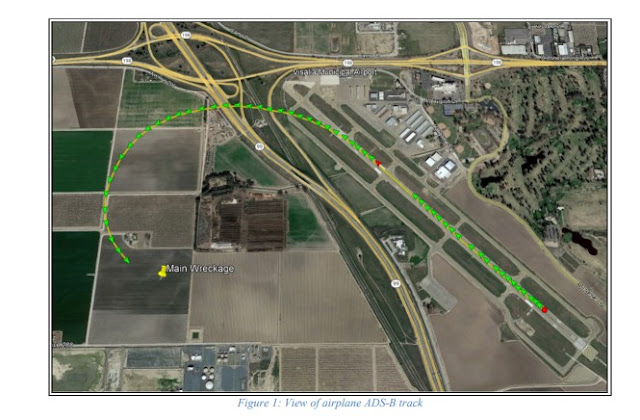
Recorded Automatic Dependent Surveillance-Broadcast (ADS-B) data provided by the Federal Aviation Administration (FAA) showed that the airplane departed from runway 30 at 0237:01 and ascended to 400 ft msl before a left turn was initiated. The data showed that at 0237:26, the airplane continued to ascend in a left turn and reached an altitude of 525 ft msl before a descent began. The data showed that the airplane continued descending in a left turn until ADS-B contact was lost at 0237:37, at an altitude of 300 ft msl, about 660 ft northwest of the accident site as seen in figure 1. 

The airport’s automated weather observation station reported that, at 1847 Pacific standard time, the wind was from 300° at 6 knots, visibility of 1 ¼ statute miles, ceiling overcast at 300 feet agl, temperature of 9°C and dew point temperature of 9°C, altimeter setting of 30.25 inches of mercury. 

Examination of the accident site revealed that the airplane impacted terrain about 1 mile southwest of the departure end of runway 30. The airplane came to rest on its left side, on a heading of about 265° magnetic, at an altitude of 290 ft mean sea level. The first identified point of contact (FIPC) with terrain was a ground scar/impression that was 285° magnetic and about 345 ft from the main wreckage. The ground scar/impression was about 14 ft long, 22 inches wide and 3 inches deep. The debris field was located on flat, open wheat field, on a magnetic heading of 285° degrees from the airplane, about 345 ft in length and 200 ft wide. The first identified piece of wreckage was located about 330 ft from the airplane wreckage and consisted of the airplane propeller and propeller hub. Throughout the debris path, various portions of aluminum wing skin, left wing fragments, left aileron, engine, propeller, exhaust system, foam, and plexi glass were observed. The wreckage was recovered to a secure location for further examination. 


Aircraft and Owner/Operator Information

Aircraft Make: Beech 
Registration: N7933M
Model/Series: V35 
Aircraft Category: Airplane
Amateur Built:
Operator: On file 
Operating Certificate(s) Held: None
Operator Designator Code:

Meteorological Information and Flight Plan

Conditions at Accident Site: IMC 
Condition of Light: Night
Observation Facility, Elevation: KVIS, 295 ft msl 
Observation Time: 18:47 Local
Distance from Accident Site: 0 Nautical Miles 
Temperature/Dew Point: 9°C /9°C
Lowest Cloud Condition: 
Wind Speed/Gusts, Direction: 6 knots / , 300°
Lowest Ceiling: Overcast / 300 ft AGL 
Visibility: 1.25 miles
Altimeter Setting: 30.25 inches Hg 
Type of Flight Plan Filed:
Departure Point: Visalia, CA
Destination: Sacramento, CA (KSAC)

Wreckage and Impact Information

Crew Injuries: 1 Fatal 
Aircraft Damage: Substantial
Passenger Injuries: 3 Fatal 
Aircraft Fire: None
Ground Injuries: 
Aircraft Explosion: None
Total Injuries: 4 Fatal 
Latitude, Longitude: 36.3198,-119.40696 

Those who may have information that might be relevant to the National Transportation Safety Board (NTSB) investigation may contact them by email witness@ntsb.gov, and any friends and family who want to contact investigators about the accident should email assistance@ntsb.gov. You can also call the NTSB Response Operations Center at 844-373-9922 or 202-314-6290.


On December 4, 2021 we unexpectedly lost our dear friend Karen Chelini Baker in a tragic accident that also took the lives of her beloved father, sister, and cousin. Karen was a loving wife to Brandon and devoted mother to their two children. She provided love and support for her family, friends, and community. We are devastated by this sudden loss.
 
We know that her family will now be facing many unexpected expenses, especially a funeral. There are many ways to help, however right now one of the best ways to show your love and support is through financial support. Any help you can provide will relieve the financial burden the family faces at this time.
 
All funds will be directly transferred to Karen’s husband, Brandon, by their friends (Monica Hernandez and Laura Quach Hoang).

If you're from the class of '94, please consider adding 94 to your donation — $94, $1994.


My name is Key Lewis, my long time friend Sam Bam, lost his amazing lady Donna Chelini, her father, her sister and her cousin to a tragic airplane accident on 12/4/21, The life the two of them built together in the last 11 years, and the joy they shared, will live on forever.


We are deeply saddened by the tragic loss of Stephen Chelini. He leaves behind his adoring wife, Espie, and their two daughters.

Anyone that had the pleasure of spending time with Steve and his family could see the bond and love for one another. As with any unexpected loss, we are left with feelings and questions - and a strong desire to help the family in some way. This fund is intended to help the family with funeral and memorial expenses.

The funds will be managed by his family.


Dave Chelini


SACRAMENTO, California — Friends of longtime Sacramento accordion teacher Dave Chelini are remembering him after his death in a plane crash over the weekend in Visalia, saying his legacy is the music created by scores of students he taught at Kline Music and the instruments he repaired over the years.

"They said Dave loved three things. There were 'three As.' There was the accordion, airplanes and automobiles," explained friend and fellow co-worker at Kline Music Nicolaus Meagher. "He knew how to use all of them. He could work on them. He was really a master of all of them."

Chelini, 78, and his two daughters, 46-year-old Karen Baker and 48-year-old Donna Chelini, were killed when their single-engine plane crashed in heavy fog minutes after takeoff, the Tulare County Sheriff's Office said. Dave's nephew Steven Chelini, 58, also died in the crash. The group had traveled to Visalia for a basketball game.

Dave Chelini got a job as an accordion teacher at Kline Music back in the 1960s.

Friends told KCRA that Chelini went on to work for SMUD for decades, but always wanted to return to teaching people how to play the accordion.

"The second he retired he came back, and he goes, 'I want to teach again,'" recalls Penny Kline, president of Kline Music.

Meagher said it was Chelini's love of music that brought him back to teach at the Sacramento music shop.

"He told me that, once he had time again to teach, that's what he wanted to do," Meagher said.

In recent years, Chelini mostly stuck to repairing accordions.

"He could take them apart and rebuild them," said Meagher. "He could take an old, antique accordion, that was an heirloom, and get it playing again."

Chelini would stop by the shop to pick up accordions people had dropped off -- eager to see if he could fix them.

If he couldn't, he'd let accordion owners know that, too.

"He was very honest, very honest and had a great reputation around town," Kline said. "Bring your accordion to Dave because he'll tell ya exactly the truth."

Chelini was a positive personality, friends described. A person who touched the lives of students, co-workers and musicians alike.

"We're gonna miss him, that's the only way I can put it," said Meagher. "His music's gonna live on with all these students that he taught."


VISALIA, California --   Authorities have identified the four people killed in a plane crash near the Visalia airport over the weekend.

The Tulare County Sheriff's Office says 78-year-old David Chelini, his 58-year-old nephew Steven Chelini, and his two daughters, 46-year-old Karen Baker and 48-year-old Donna Chelini were killed in Saturday's crash. The family is from the Sacramento area.

The Beechcraft V35 Bonanza aircraft took off from Visalia Municipal Airport at about 6:40 pm, then crashed just 16 seconds later at Road 68 and Avenue 288, just west of the airport.

Investigators from the Federal Aviation Administration (FAA) and the National Transportation Safety Board (NTSB) arrived in the South Valley on Sunday to begin looking into why the plane was derailed just moments after it took off.

First responders say the fog was thick when they arrived.

With no fire from the crash, it wasn't easy to immediately find the plane.

"When we all responded, we were searching for the plane," said Sgt. Jesse Cox with the sheriff's office.

"The area is a large reservoir area and it's hard to get back there. We need to go on foot... We just circulated the area as much personnel as we had until we found it," he added.

Once the plane was found, the sheriff's office confirmed all four people on board died in the crash.

The National Transportation Safety Board and Federal Aviation Administration arrived Sunday afternoon to take over the investigation.

The NTSB says the wreckage field from the crash is about 500 feet long, with debris scattered in all directions.

Investigators are taking photographs and conducting the ground investigation before the plane is moved to a secure location for further analysis.


Four people are dead after a plane crashed west of the Visalia Municipal Airport, sheriff's officials said.

Emergency crews responded after receiving a call just after 6:30 p.m. that a small plane was down near the airport. Detectives and deputies from the Tulare County Sheriff's Office are also on the scene of the crash near Highway 99 in Visalia.

The plane left Visalia Municipal Airport at 6:37 p.m., Sgt. Jesse Cox said. Around four minutes elapsed between takeoff and the first 911 call.

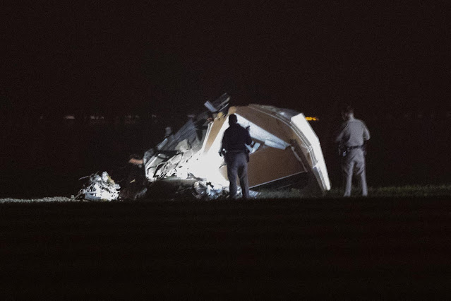
It took first responders some time to locate the wreckage due to the dense fog in the area. Photos of the wreckage show a crumpled cabin and debris in front of an orchard, near the Visalia Water Reclamation Facility on Avenue 288.

"It was dark. At the time, it was much foggier," Cox said. "We circulated the area with personnel until we found it (the wreckage)."

Deputies said ambulances and firefighters were at the scene shortly after the crash.

The National Transportation Safety Board is en route to the area and is investigating the crash of a Beech V35 Bonanza in Visalia. The Federal Aviation Administration as well as the National Transportation Safety Board are expected to arrive on Sunday.

A plane with the tail number N7933M left the Visalia airport at 6:37 p.m., according to flight records. The Beechcraft V35 Bonanza is registered to David Chelini out of Sacramento, according to a publicly searchable FAA database.

Detectives have not identified any victims.

Details surrounding the crash will have to wait until transportation safety officials complete their investigation, which could take weeks.