Tuesday, June 15, 2021

Cessna 172L Skyhawk, N1333M: Incident occurred June 14, 2021 near Kelly Field Airport (KSKF), San Antonio, Texas

Federal Aviation Administration / Flight Standards District Office; San Antonio, Texas

Aircraft made an emergency landing in a field due to partial power loss on departure. 

JIL Aviation Inc 


Date: 14-JUN-21
Time: 23:30:00Z
Regis#: N1333M
Aircraft Make: CESSNA
Aircraft Model: 172
Event Type: INCIDENT
Highest Injury: NONE
Aircraft Missing: No
Damage: UNKNOWN
Activity: INSTRUCTION
Flight Phase: TAKEOFF (TOF)
Operation: 91
City: SAN ANTONIO
State: TEXAS

Diamond DA20-C1 Eclipse, N458MA: Accident occurred June 14, 2021 in Mathews, Virginia

This is preliminary information, subject to change, and may contain errors. Any errors in this report will be corrected when the final report has been completed.

The National Transportation Safety Board did not travel to the scene of this accident.

Additional Participating Entity:
Federal Aviation Administration / Flight Standards District Office; Richmond, Virginia 

Location: Matthews, VA
Accident Number: ERA21LA250
Date & Time: June 14, 2021, 12:30 Local 
Registration: N458MA
Aircraft: Diamond DA20
Injuries: 2 Minor
Flight Conducted Under: Part 91: General aviation - Instructional

On June 14, 2021, about 1230 eastern daylight time, a Diamond DA20-C1, N458MA, was substantially damaged when it was involved in an accident near Matthews, Virginia. The flight instructor and student pilot sustained minor injuries. The airplane was operated as a Title 14 Code of Federal Regulations Part 91 instructional flight.

The flight instructor reported that during a short cross-country flight to Tangier Island in Chesapeake Bay, air traffic control instructed the flight to descend from 5,500 ft mean sea level (msl) to 2,500 ft msl, due to an active military operations area. After the student pilot leveled the airplane at 2,500 ft msl, the flight instructor noticed engine vibration and roughness that he initially corrected by advancing the throttle from 1,900 to 2,200 rpm; however, the engine subsequently shook “violently” followed by a total loss of engine power. The flight instructor took control of the airplane and realized that there was not enough altitude to glide to a shore. The flight instructor then ditched the airplane in Chesapeake Bay near a fishing trawler where he and the student pilot were rescued.

The wreckage was recovered about 2 weeks after the accident and retained for further examination.

Aircraft and Owner/Operator Information

Aircraft Make: Diamond 
Registration: N458MA
Model/Series: DA20 C1
Aircraft Category: Airplane
Amateur Built: No
Operator: 
Operating Certificate(s) Held: Pilot school (141)
Operator Designator Code:

Meteorological Information and Flight Plan

Conditions at Accident Site: VMC 
Condition of Light: Day
Observation Facility, Elevation: KPHF,42 ft msl
Observation Time: 12:54 Local
Distance from Accident Site: 19 Nautical Miles 
Temperature/Dew Point: 28°C /21°C
Lowest Cloud Condition: Clear
Wind Speed/Gusts, Direction: 7 knots / , 260°
Lowest Ceiling: None 
Visibility: 10 miles
Altimeter Setting: 29.85 inches Hg 
Type of Flight Plan Filed: VFR
Departure Point: Manassas, VA (HEF) 
Destination: Tangier Island, VA (TGI)

Wreckage and Impact Information

Crew Injuries: 2 Minor
Aircraft Damage: Substantial
Passenger Injuries: N/A
Aircraft Fire: None
Ground Injuries: N/A
Aircraft Explosion: None
Total Injuries: 2 Minor 
Latitude, Longitude: 37.371667,-76.228333 (est)

Lancair 360, N26KF: Incident occurred June 14, 2021 in Dublin, Pulaski County, Virginia

Federal Aviation Administration / Flight Standards District Office; Charleston

Aircraft landed and gear collapsed. 


Date: 14-JUN-21
Time: 15:30:00Z
Regis#: N26KF
Aircraft Make: LANCAIR
Aircraft Model: 360
Event Type: INCIDENT
Highest Injury: NONE
Aircraft Missing: No
Damage: UNKNOWN
Activity: PERSONAL
Flight Phase: LANDING (LDG)
Operation: 91
City: DUBLIN
State: VIRGINIA

Schweizer SGS 2-33A, N33929: Accident occurred June 13, 2021 at Rockfish Airport (VG22), Nellysford, Nelson County, Virginia

This is preliminary information, subject to change, and may contain errors. Any errors in this report will be corrected when the final report has been completed.

The National Transportation Safety Board did not travel to the scene of this accident. 

Additional Participating Entity:
Federal Aviation Administration / Flight Standards District Office; Richmond, Virginia

Shenandoah Valley Soaring Inc


Location: Nellysford, VA
Accident Number: ERA21LA248
Date & Time: June 13, 2021, 16:30 Local 
Registration: N33929
Aircraft: Schweizer SGS 2-33A 
Injuries: 1 Serious, 1 None
Flight Conducted Under: Part 91: General aviation - Instructional

Aircraft and Owner/Operator Information

Aircraft Make: Schweizer
Registration: N33929
Model/Series: SGS 2-33A 
Aircraft Category: Glider
Amateur Built: No
Operator: 
Operating Certificate(s) Held: None
Operator Designator Code:

Meteorological Information and Flight Plan

Conditions at Accident Site: VMC
Condition of Light: Day
Observation Facility, Elevation: SHD,1201 ft msl
Observation Time: 14:35 Local
Distance from Accident Site: 23 Nautical Miles
Temperature/Dew Point: 29°C /20°C
Lowest Cloud Condition: Scattered / 3400 ft AGL 
Wind Speed/Gusts, Direction: 3 knots / , 130°
Lowest Ceiling: Broken / 7500 ft AGL 
Visibility: 10 miles
Altimeter Setting: 29.93 inches Hg
Type of Flight Plan Filed:
Departure Point: Nellysford, VA
Destination: Nellysford, VA

Wreckage and Impact Information

Crew Injuries: 1 Serious, 1 None
Aircraft Damage: None
Passenger Injuries:
Aircraft Fire: None
Ground Injuries: 
Aircraft Explosion: None
Total Injuries: 1 Serious, 1 None
Latitude, Longitude: 37.879582,-78.893634

Pitts S–1, N333SB: Incident occurred June 12, 2021 at Zamperini Field Airport (KTOA), Torrance, California

Federal Aviation Administration / Flight Standards District Office; Long Beach, California

Aircraft ground looped after landing.  


Date: 12-JUN-21
Time: 01:06:00Z
Regis#: N333SB
Aircraft Make: AVIAT
Aircraft Model: PITTS S-1
Event Type: INCIDENT
Highest Injury: NONE
Aircraft Missing: No
Damage: MINOR
Activity: PERSONAL
Flight Phase: LANDING (LDG)
Operation: 91
City: TORRANCE
State: CALIFORNIA

Diamond DA42MNG, N640SH: Incident occurred June 11, 2021 at Livermore Municipal Airport (KLVK), Alameda County, California

Federal Aviation Administration / Flight Standards District Office; Oakland, California

Aircraft on takeoff, rear cabin door separated.  


Date: 11-JUN-21
Time: 17:17:00Z
Regis#: N640SH
Aircraft Make: DIAMOND
Aircraft Model: DA42
Event Type: INCIDENT
Highest Injury: NONE
Aircraft Missing: No
Damage: MINOR
Activity: PERSONAL
Flight Phase: TAKEOFF (TOF)
Operation: 91
City: LIVERMORE
State: CALIFORNIA

Boeing 737-700, N948WN: Incident occurred June 12, 2021 at Denver International Airport (KDEN), Colorado

Federal Aviation Administration / Flight Standards District Office; Denver, Colorado

Aircraft on pushback from gate was struck by SUV. 

Southwest Airlines Co


Date: 12-JUN-21
Time: 21:55:00Z
Regis#: N948WN
Aircraft Make: BOEING
Aircraft Model: 737
Event Type: INCIDENT
Highest Injury: NONE
Aircraft Missing: No
Damage: UNKNOWN
Activity: COMMERCIAL
Flight Phase: PUSHBACK/TOWING (PBT)
Operation: 121
Aircraft Operator: SOUTHWEST AIRLINES
Flight Number: SWA4117
City: DENVER
State: COLORADO

Loss of Control on Ground: Cessna 172R Skyhawk, N430EP; accident occurred June 13, 2021 at Groton - New London Airport (KGON), Connecticut


Aviation Accident Final Report - National Transportation Safety Board
 

The National Transportation Safety Board did not travel to the scene of this accident. 

Additional Participating Entity: 
Federal Aviation Administration / Flight Standards District Office; Windsor Locks

Investigation Docket - National Transportation Safety Board: https://data.ntsb.gov/Docket

Sunshine Holding LLC

Arrow Aviation LLLC


Location: Groton, Connecticut
Accident Number: ERA21LA249
Date and Time: June 13, 2021, 17:00 Local 
Registration: N430EP
Aircraft: Cessna 172R 
Aircraft Damage: Substantial
Defining Event: Loss of control on ground 
Injuries: 1 None
Flight Conducted Under: Part 91: General aviation - Instructional

Analysis

The student pilot reported that he was flying a visual approach at the conclusion of a solo cross-country flight. Following a reportedly normal approach and landing, when the nose landing gear contacted the runway, the airplane began to veer to the left and “tilted somewhat.” The airplane then quickly veered further left and departed the runway surface. The airplane collided with a runway distance sign and came to a stop in the grass.

According to an inspector with the Federal Aviation Administration, the airplane’s horizontal stabilizer and elevator were substantially damaged. He performed an examination of the flight controls, wheels, and wheel brakes; no evidence of a preexisting mechanical malfunction or failure was found. There was a tire skid mark on the runway, leading from the runway centerline to the wreckage.

Probable Cause and Findings

The National Transportation Safety Board determines the probable cause(s) of this accident to be:
The pilot’s failure to maintain directional control of the airplane during landing, resulting in a runway excursion and collision with an airport sign.

Findings
Aircraft Directional control - Not attained/maintained
Personnel issues Aircraft control - Pilot

Factual Information

History of Flight

Landing-landing roll Loss of control on ground (Defining event)
Landing-landing roll Runway excursion
Landing-landing roll Collision during takeoff/land

Student pilot Information

Certificate: Student 
Age: 62, Male
Airplane Rating(s): None
Seat Occupied: Left
Other Aircraft Rating(s): None
Restraint Used: 3-point
Instrument Rating(s): None
Second Pilot Present: No
Instructor Rating(s): None 
Toxicology Performed:
Medical Certification: Class 3 Without waivers/limitations
Last FAA Medical Exam: July 11, 2019
Occupational Pilot: No
Last Flight Review or Equivalent:
Flight Time: 101 hours (Total, all aircraft), 101 hours (Total, this make and model), 8 hours (Pilot In Command, all aircraft), 13 hours (Last 90 days, all aircraft), 4 hours (Last 30 days, all aircraft)

Aircraft and Owner/Operator Information

Aircraft Make: Cessna
Registration: N430EP
Model/Series: 172R 
Aircraft Category: Airplane
Year of Manufacture: 1998 
Amateur Built:
Airworthiness Certificate: Normal
Serial Number: 17280648
Landing Gear Type: Tricycle
Seats: 4
Date/Type of Last Inspection: June 8, 2021 100 hour
Certified Max Gross Wt.: 2550 lbs
Time Since Last Inspection: 12 Hrs
Engines: 1 Reciprocating
Airframe Total Time: 4759 Hrs at time of accident 
Engine Manufacturer: Lycoming
ELT: Installed, not activated 
Engine Model/Series: IO-360-L2A
Registered Owner: 
Rated Power: 180 Horsepower
Operator: 
Operating Certificate(s) Held: None

Meteorological Information and Flight Plan

Conditions at Accident Site: Visual (VMC)
Condition of Light: Day
Observation Facility, Elevation: GON, 10 ft msl
Distance from Accident Site: 1 Nautical Miles
Observation Time: 16:56 Local 
Direction from Accident Site: 236°
Lowest Cloud Condition: Few / 9500 ft AGL
Visibility: 10 miles
Lowest Ceiling: None 
Visibility (RVR):
Wind Speed/Gusts: 7 knots / 
Turbulence Type Forecast/Actual: None / None
Wind Direction: 190° 
Turbulence Severity Forecast/Actual: N/A / N/A
Altimeter Setting: 29.91 inches Hg 
Temperature/Dew Point: 20°C / 16°C
Precipitation and Obscuration: No Obscuration; No Precipitation
Departure Point: Windham, CT (IJD) 
Type of Flight Plan Filed: None
Destination: Groton, CT
Type of Clearance: VFR
Departure Time: 16:38 Local
Type of Airspace: Class D

Airport Information

Airport: GROTON-NEW LONDON GON 
Runway Surface Type: Asphalt
Airport Elevation: 9 ft msl
Runway Surface Condition: Dry
Runway Used: 05/23
IFR Approach: None
Runway Length/Width: 5000 ft / 150 ft
VFR Approach/Landing: Full stop; Straight-in

Wreckage and Impact Information

Crew Injuries: 1 None 
Aircraft Damage: Substantial
Passenger Injuries:
Aircraft Fire: None
Ground Injuries:
Aircraft Explosion: None
Total Injuries: 1 None
Latitude, Longitude: 41.33295,-72.03935 (est)

Robinson R66 Turbine, N857TL: Accident occurred July 30, 2021 and Incident occurred June 10, 2021

This is preliminary information, subject to change, and may contain errors. Any errors in this report will be corrected when the final report has been completed. 

The National Transportation Safety Board did not travel to the scene of this accident. 

Additional Participating Entity: 
Federal Aviation Administration / Flight Standards District Office; Lincoln, Nebraska

Higgins Leasing Inc


Location: Merry, Nebraska
Accident Number: CEN21LA348
Date and Time: July 30, 2021, 12:00 Local 
Registration: N857TL
Aircraft: ROBINSON HELICOPTER CO R66
Injuries: 1 Serious
Flight Conducted Under: Part 137: Agricultural

Aircraft and Owner/Operator Information

Aircraft Make: ROBINSON HELICOPTER CO
Registration: N857TL
Model/Series: R66
Aircraft Category: Helicopter
Amateur Built:
Operator: 
Operating Certificate(s) Held: None
Operator Designator Code:

Meteorological Information and Flight Plan

Conditions at Accident Site:
Condition of Light:
Observation Facility, Elevation:
Observation Time:
Distance from Accident Site: 
Temperature/Dew Point:
Lowest Cloud Condition:
Wind Speed/Gusts, Direction: / ,
Lowest Ceiling:
Visibility:
Altimeter Setting: 
Type of Flight Plan Filed:
Departure Point: 
Destination:

Wreckage and Impact Information

Crew Injuries: 1 Serious
Aircraft Damage: Substantial
Passenger Injuries: N/A
Aircraft Fire: None
Ground Injuries:
Aircraft Explosion: None
Total Injuries: 1 Serious
Latitude, Longitude: 41.8667,101.9171 (est)


THURSTON COUNTY, Nebraska — UPDATE: The FAA says a serious injury occurred after a helicopter crashed last Friday in Thurston County.

An FAA Aviation Safety report states that a Robinson R66 struck powerlines and crashed in a field near Pender, Nebraska.

There was one serious injury and the helicopter had substantial damage.

PREVIOUS STORY:

Authorities in Thurston County are investigating after a helicopter crashes Friday afternoon at about 2:00 pm.

The Sheriff's Office says that a helicopter did go down while spraying fields in the area.

No information if there were any injuries was released.

The accident remains under investigation.


Federal Aviation Administration / Flight Standards District Office; Alabama and NW Florida

June 10, 2021:  Rotorcraft made a hard landing at Destin Executive Airport (KDTS), Okaloosa County, Florida.


Date: 10-JUN-21
Time: 15:35:00Z
Regis#: N857TL
Aircraft Make: ROBINSON
Aircraft Model: R66
Event Type: INCIDENT
Highest Injury: NONE
Aircraft Missing: No
Damage: MINOR
Activity: PERSONAL
Flight Phase: LANDING (LDG)
Operation: 91
City: DESTIN
State: FLORIDA

Great Lakes 2T-1A-2, N4008L: Incident occurred June 11, 2021 at Bozeman Yellowstone International Airport (KBZN), Gallatin County, Montana

Federal Aviation Administration / Flight Standards District Office; Helena, Montana

Aircraft landed in the grass.  


Date: 11-JUN-21
Time: 18:58:00Z
Regis#: N4008L
Aircraft Make: GREAT LAKES
Aircraft Model: 2T-1A
Event Type: INCIDENT
Highest Injury: NONE
Aircraft Missing: No
Damage: NONE
Activity: PERSONAL
Flight Phase: LANDING (LDG)
Operation: 91
City: BOZEMAN
State: MONTANA

Boeing B75N1, N777JG: Accident occurred June 13, 2021 in Elwood, Gosper County, Nebraska

This is preliminary information, subject to change, and may contain errors. Any errors in this report will be corrected when the final report has been completed. 

The National Transportation Safety Board did not travel to the scene of this accident. 

Additional Participating Entity: 
Federal Aviation Administration / Flight Standards District Office; Lincoln, Nebraska


Location: Elwood, NE
Accident Number: CEN21LA264
Date & Time: June 13, 2021, 13:30 Local 
Registration: N777JG
Aircraft: Boeing B75N1 
Injuries: 1 Minor
Flight Conducted Under: Part 91: General aviation - Personal

On June 13, 2021, about 1330 central daylight time, a Boeing B75N1 Stearman airplane, N777JG, was substantially damaged when it was involved in an accident near Elwood, Nebraska. The pilot sustained minor injuries. The airplane was operated as a Title 14 Code of Federal Regulations Part 91 personal flight.

The pilot reported that he had been flying for about 2 hours with no issues. While in cruise flight about 1,000 ft above ground level, he experienced a “loud bang” and the engine started shaking. He moved the throttle to idle; however, the shaking seemed to get worse. He applied full throttle and the shaking smoothed out. The pilot attempted to divert to a grass airstrip but was unable to maintain
altitude. He executed a forced landing to a corn field about 1/2-mile from the airstrip. The landing gear dug into the soft dirt and the airplane nosed over. The wings were substantially damaged.

A postaccident engine examination is planned.

Aircraft and Owner/Operator Information

Aircraft Make: Boeing 
Registration: N777JG
Model/Series: B75N1
Aircraft Category: Airplane
Amateur Built: No
Operator: On file
Operating Certificate(s) Held: None
Operator Designator Code:

Meteorological Information and Flight Plan

Conditions at Accident Site: VMC 
Condition of Light: Day
Observation Facility, Elevation: LXN,2413 ft msl
Observation Time: 13:35 Local
Distance from Accident Site: 0.5 Nautical Miles
Temperature/Dew Point: 31°C /17°C
Lowest Cloud Condition: Clear 
Wind Speed/Gusts, Direction: 9 knots / , 190°
Lowest Ceiling: None
Visibility: 10 miles
Altimeter Setting: 30.12 inches Hg
Type of Flight Plan Filed: None
Departure Point: Kearney, NE (EAR)
Destination: Cozad, NE (CZD)

Wreckage and Impact Information

Crew Injuries: 1 Minor 
Aircraft Damage: Substantial
Passenger Injuries: 
Aircraft Fire: None
Ground Injuries:
Aircraft Explosion: None
Total Injuries: 1 Minor
Latitude, Longitude: 40.70839,-99.83443 (est)

Loss of Control on Ground: Cessna 172M, N20406; accident occurred June 12, 2021 in Fields, Harney County, Oregon


Aviation Accident Final Report - National Transportation Safety Board

The National Transportation Safety Board did not travel to the scene of this accident. 

Additional Participating Entity:
Federal Aviation Administration / Flight Standards District Office; Portland, Oregon

Investigation Docket - National Transportation Safety Board: https://data.ntsb.gov/Docket
Location: Fields, Oregon
Accident Number: WPR21LA230
Date and Time: June 12, 2021, 09:45 Local
Registration: N20406
Aircraft: Cessna 172
Aircraft Damage: Substantial
Defining Event: Loss of control on ground
Injuries: 1 None
Flight Conducted Under: Part 91: General aviation - Personal

Analysis

The pilot reported that, he initiated a landing on a highway near a remote town for lunch. After touchdown, the airplane veered left, and the pilot applied full right rudder control input, but the airplane exited the roadway surface and impacted terrain. The airplane nosed over, and the right-wing lift strut and empennage sustained substantial damage. The pilot reported that there were no preaccident mechanical malfunctions or failures with the airplane that would have precluded normal operation.

Probable Cause and Findings

The National Transportation Safety Board determines the probable cause(s) of this accident to be:
The pilot’s failure to maintain directional control during landing on a highway, which resulted in an impact with terrain and subsequent nose over.

Findings

Aircraft Directional control - Not attained/maintained
Personnel issues Aircraft control - Pilot
Environmental issues Rough terrain - Effect on operation

Factual Information

History of Flight

Landing-flare/touchdown Loss of control on ground (Defining event)
Landing-landing roll Collision during takeoff/land

Pilot Information

Certificate: Private 
Age: 64, Male
Airplane Rating(s): Single-engine land 
Seat Occupied: Left
Other Aircraft Rating(s): None
Restraint Used: 3-point
Instrument Rating(s): None 
Second Pilot Present: No
Instructor Rating(s): None 
Toxicology Performed:
Medical Certification: Class 3 With waivers/limitations 
Last FAA Medical Exam: March 24, 2020
Occupational Pilot: No 
Last Flight Review or Equivalent: June 9, 2021
Flight Time: (Estimated) 338.4 hours (Total, all aircraft), 310.8 hours (Total, this make and model), 251.8 hours (Pilot In Command, all aircraft), 11.7 hours (Last 90 days, all aircraft), 10.6 hours (Last 30 days, all aircraft), 1.3 hours (Last 24 hours, all aircraft)

Aircraft and Owner/Operator Information

Aircraft Make: Cessna
Registration: N20406
Model/Series: 172 M
Aircraft Category: Airplane
Year of Manufacture: 1972
Amateur Built:
Airworthiness Certificate: Normal; Utility 
Serial Number: 17261265
Landing Gear Type: Tricycle
Seats: 4
Date/Type of Last Inspection: December 23, 2020 Annual
Certified Max Gross Wt.: 2300 lbs
Time Since Last Inspection: 42 Hrs 
Engines: 1 Reciprocating
Airframe Total Time: 5856.2 Hrs at time of accident
Engine Manufacturer: Lycoming
ELT: Installed, not activated 
Engine Model/Series: 0-320-E2D
Registered Owner: 
Rated Power:
Operator: 
Operating Certificate(s) Held: None

Meteorological Information and Flight Plan

Conditions at Accident Site: Visual (VMC)
Condition of Light: Day
Observation Facility, Elevation: KREO, 4050 ft msl 
Distance from Accident Site: 41 Nautical Miles
Observation Time: 08:52 Local 
Direction from Accident Site: 61°
Lowest Cloud Condition: 
Visibility:
Lowest Ceiling: 
Visibility (RVR):
Wind Speed/Gusts: / 
Turbulence Type
Forecast/Actual: None / None
Wind Direction: 
Turbulence Severity Forecast/Actual: N/A / N/A
Altimeter Setting: 30.1 inches Hg 
Temperature/Dew Point: 18°C / 7°C
Precipitation and Obscuration: No Obscuration; No Precipitation
Departure Point: Burns, OR (KNBO)
Type of Flight Plan Filed: None
Destination: Fields, OR 
Type of Clearance: None
Departure Time: 09:30 Local
Type of Airspace: Class G

Wreckage and Impact Information

Crew Injuries: 1 None 
Aircraft Damage: Substantial
Passenger Injuries:
Aircraft Fire: None
Ground Injuries:
Aircraft Explosion: None
Total Injuries: 1 None 
Latitude, Longitude: 42.264206,-118.67499 (est)

Bombardier BD-700-1A10, N470B: Incident occurred June 13, 2021 at T. F. Green International Airport (KPVD), Providence, Rhode Island

Federal Aviation Administration / Flight Standards District Office; Boston, Massachusetts

Aircraft while parking struck the wing of Cessna 208B Super Cargomaster, N865FE, which was parked. 

Reina Capital LLC


Date: 13-JUN-21
Time: 22:15:00Z
Regis#: N470B
Aircraft Make: BOMBARDIER
Aircraft Model: BD-700
Event Type: INCIDENT
Highest Injury: NONE
Aircraft Missing: No
Damage: UNKNOWN
Activity: UNKNOWN
Flight Phase: TAXI (TXI)
City: PROVIDENCE
State: RHODE ISLAND

Cessna 152, N5403H: Incident occurred June 13, 2021 in Bellevue, Clay County, Texas

Federal Aviation Administration / Flight Standards District Office; North Texas

Aircraft made a forced landing on a road. 

US Aviation Group LLC


Date: 13-JUN-21
Time: 01:40:00Z
Regis#: N5403H
Aircraft Make: CESSNA
Aircraft Model: 152
Event Type: INCIDENT
Highest Injury: NONE
Aircraft Missing: No
Damage: UNKNOWN
Activity: PERSONAL
Flight Phase: LANDING (LDG)
Operation: 91
City: BELLEVUE
State: TEXAS

Collision with Object (non-CFIT): Piper PA-28-150 Cherokee, N5853W; accident occurred June 12, 2021 at Covey Trails Airport (X09), Fulshear, Fort Bend County, Texas


Aviation Accident Final Report - National Transportation Safety Board

The National Transportation Safety Board did not travel to the scene of this accident. 

Additional Participating Entity: 

Federal Aviation Administration / Flight Standards District Office; Houston, Texas

Investigation Docket - National Transportation Safety Board: https://data.ntsb.gov/Docket 
Location: Fulshear, Texas
Accident Number: CEN21LA282
Date and Time: June 12, 2021, 08:50 Local 
Registration: N5853W
Aircraft: Piper PA-28-150 
Aircraft Damage: Substantial
Defining Event: Collision with terr/obj (non-CFIT) 
Injuries: 1 None
Flight Conducted Under: Part 91: General aviation - Personal

Analysis

The pilot reported that while on approach to land, he allowed the airplane to get too low and struck a fence before the approach end of the runway. The airplane sustained substantial damage to both wings. The pilot reported that there were no preimpact mechanical failures or malfunctions with the airplane that would have precluded normal operation.

Probable Cause and Findings

The National Transportation Safety Board determines the probable cause(s) of this accident to be:
The pilot’s failure to maintain a proper glidepath during the landing approach, which led to an impact with a fence.

Findings

Aircraft Descent/approach/glide path - Not attained/maintained
Personnel issues Aircraft control - Pilot
Environmental issues Fence/fence post - Not specified

Factual Information

History of Flight

Landing Collision with terr/obj (non-CFIT) (Defining event)

Pilot Information

Certificate: Private 
Age: 80, Male
Airplane Rating(s): Single-engine land
Seat Occupied: Left
Other Aircraft Rating(s): None 
Restraint Used: 3-point
Instrument Rating(s): Airplane 
Second Pilot Present:
Instructor Rating(s): None 
Toxicology Performed:
Medical Certification: BasicMed 
Last FAA Medical Exam:
Occupational Pilot: No
Last Flight Review or Equivalent:
Flight Time: 1587 hours (Total, all aircraft), 421 hours (Total, this make and model)

Aircraft and Owner/Operator Information

Aircraft Make: Piper
Registration: N5853W
Model/Series: PA-28-150 
Aircraft Category: Airplane
Year of Manufacture: 1965
Amateur Built:
Airworthiness Certificate: Normal
Serial Number: 28-2322
Landing Gear Type: Tricycle 
Seats: 4
Date/Type of Last Inspection: Unknown 
Certified Max Gross Wt.:
Time Since Last Inspection:
Engines: 1 Reciprocating
Airframe Total Time:
Engine Manufacturer: Lycoming
ELT: 
Engine Model/Series: O-320
Registered Owner:
Rated Power:
Operator: On file
Operating Certificate(s) Held: None

Meteorological Information and Flight Plan

Conditions at Accident Site: Visual (VMC) 
Condition of Light: Day
Observation Facility, Elevation: KTME,168 ft msl 
Distance from Accident Site: 7 Nautical Miles
Observation Time: 09:55 Local
Direction from Accident Site: 335°
Lowest Cloud Condition: Clear 
Visibility: 9 miles
Lowest Ceiling: None 
Visibility (RVR):
Wind Speed/Gusts: / 
Turbulence Type Forecast/Actual:  /
Wind Direction:
Turbulence Severity Forecast/Actual:  /
Altimeter Setting: 30.01 inches Hg
Temperature/Dew Point: 29°C / 25°C
Precipitation and Obscuration: No Obscuration; No Precipitation
Departure Point: Fulshear, TX
Type of Flight Plan Filed: None
Destination: Fulshear, TX
Type of Clearance: None
Departure Time: 
Type of Airspace:

Airport Information

Airport: COVEY TRAILS X09 
Runway Surface Type: Grass/turf
Airport Elevation: 130 ft msl 
Runway Surface Condition: Dry
Runway Used: 17/35
IFR Approach: None
Runway Length/Width: 3352 ft / 100 ft
VFR Approach/Landing: Full stop; Traffic pattern

Wreckage and Impact Information

Crew Injuries: 1 None 
Aircraft Damage: Substantial
Passenger Injuries: N/A
Aircraft Fire: None
Ground Injuries:
Aircraft Explosion: None
Total Injuries: 1 None
Latitude, Longitude: 29.690083,-95.840474

Vultee BT-13A Valiant, N9743N: Incident occurred June 12, 2021 at City of Slaton - Larry T. Neal Memorial Airport (F49), Lubbock County, Texas

Federal Aviation Administration / Flight Standards District Office; Lubbock, Texas

Aircraft landed and veered off runway snapping the tail wheel off.  


Date: 12-JUN-21
Time: 19:20:00Z
Regis#: N9743N
Aircraft Make: CONSOLIDATED VULTEE
Aircraft Model: BT-13A
Event Type: INCIDENT
Highest Injury: NONE
Aircraft Missing: No
Damage: MINOR
Activity: PERSONAL
Flight Phase: LANDING (LDG)
Operation: 91
City: SLATON
State: TEXAS

Velocity, N21HV: Incidents occurred June 12, 2021 and August 31, 2019

Federal Aviation Administration / Flight Standards District Office; Seattle, Washington

June 12, 2021:  Aircraft landed hard and veered off runway at Snohomish County Airport (KPAE), Everett, Washington


Date: 12-JUN-21
Time: 21:00:00Z
Regis#: N21HV
Aircraft Make: VELOCITY
Aircraft Model: SUV 103
Event Type: INCIDENT
Highest Injury: NONE
Aircraft Missing: No
Damage: UNKNOWN
Activity: PERSONAL
Flight Phase: LANDING (LDG)
Operation: 91
City: EVERETT
State: WASHINGTON

Federal Aviation Administration / Flight Standards District Office; Seattle, Washington

August 31, 2019:  Aircraft veered off runway while landing at Friday Harbor Airport (KFHR), San Juan County, Washington.

Date: 31-AUG-19
Time: 23:00:00Z
Regis#: N21HV
Aircraft Make: EXPERIMENTAL
Aircraft Model: VELOCITY
Event Type: INCIDENT
Highest Injury: NONE
Aircraft Missing: No
Damage: MINOR
Activity: PERSONAL
Flight Phase: LANDING (LDG)
Operation: 91
City: FRIDAY HARBOR
State: WASHINGTON

Loss of Control on Ground: Jabiru J250-SP, N214RM; accident occurred June 05, 2021 at Donegal Springs Airpark (N71), Marietta, Lancaster County, Pennsylvania


Aviation Accident Final Report - National Transportation Safety Board

The National Transportation Safety Board did not travel to the scene of this accident.

Additional Participating Entity: 
Federal Aviation Administration / Flight Standards District Office; Harrisburg, Pennsylvania 

Investigation Docket - National Transportation Safety Board:

RNM Inc


Location: Marietta, Pennsylvania
Accident Number: ERA21LA243
Date and Time: June 5, 2021, 13:00 Local 
Registration: N214RM
Aircraft: JABIRU USA SPORT AIRCRAFT LLC J250-SP 
Aircraft Damage: Substantial
Defining Event: Loss of control on ground
Injuries: 2 None
Flight Conducted Under: Part 91: General aviation - Instructional

Analysis

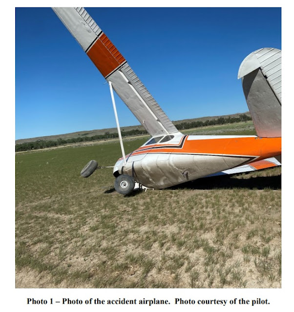
The pilot had just purchased the airplane and hired the flight instructor to give him some lessons before he flew home. He took off and performed several maneuvers before coming back to the airport to practice full stop landings. He said the final landing was smooth, but during the rollout, his left foot slipped off the rudder pedal while his right foot was still pressing on the right rudder pedal. The airplane swerved to the right, departed the runway, and came to rest in a wheat field. During the accident sequence, the right main and nose landing gear collapsed, and the lower fuselage and firewall were substantially damaged.

Probable Cause and Findings

The National Transportation Safety Board determines the probable cause(s) of this accident to be:
The pilot’s failure to maintain directional control during the landing roll.

Findings
Aircraft Directional control - Not attained/maintained
Personnel issues Aircraft control - Pilot

Factual Information

History of Flight

Landing-landing roll Loss of control on ground (Defining event)
Landing-landing roll Runway excursion
Landing-landing roll Landing gear collapse

Flight instructor Information

Certificate: Airline transport; Flight instructor 
Age: 66,Male
Airplane Rating(s): Single-engine land; Multi-engine land
Seat Occupied: Right
Other Aircraft Rating(s): Helicopter
Restraint Used: 3-point
Instrument Rating(s): Airplane
Second Pilot Present: Yes
Instructor Rating(s): Airplane single-engine; Instrument airplane
Toxicology Performed:
Medical Certification: BasicMed With waivers/limitations 
Last FAA Medical Exam: June 9, 2019
Occupational Pilot: No
Last Flight Review or Equivalent: June 20, 2020
Flight Time: (Estimated) 4700 hours (Total, all aircraft), 40 hours (Total, this make and model), 60 hours (Last 90 days, all aircraft), 30 hours (Last 30 days, all aircraft), 2 hours (Last 24 hours, all aircraft)

Pilot Information

Certificate: Private
Age: 66, Male
Airplane Rating(s): Single-engine land 
Seat Occupied: Left
Other Aircraft Rating(s): None 
Restraint Used: 3-point
Instrument Rating(s): None 
Second Pilot Present: Yes
Instructor Rating(s): None
Toxicology Performed:
Medical Certification: Class 3 With waivers/limitations
Last FAA Medical Exam: February 17, 2021
Occupational Pilot: No 
Last Flight Review or Equivalent: October 19, 2020
Flight Time: 178 hours (Total, all aircraft), 3 hours (Total, this make and model), 3 hours (Last 24 hours, all aircraft)

Aircraft and Owner/Operator Information

Aircraft Make: JABIRU USA SPORT AIRCRAFT LLC
Registration: N214RM
Model/Series: J250-SP 
Aircraft Category: Airplane
Year of Manufacture: 2006
Amateur Built:
Airworthiness Certificate: Special light-sport (Special)
Serial Number: 249
Landing Gear Type: Tricycle 
Seats: 2
Date/Type of Last Inspection: May 21, 2021 Annual
Certified Max Gross Wt.: 1320 lbs
Time Since Last Inspection: 10 Hrs
Engines: 1 Reciprocating
Airframe Total Time: 1976 Hrs at time of accident 
Engine Manufacturer: JABIRU
ELT: Installed, not activated
Engine Model/Series: 3300
Registered Owner: 
Rated Power: 120 Horsepower
Operator: On file
Operating Certificate(s) Held: None

Meteorological Information and Flight Plan

Conditions at Accident Site: Visual (VMC) 
Condition of Light: Day
Observation Facility, Elevation: MDT, 312 ft msl
Distance from Accident Site: 11 Nautical Miles
Observation Time: 12:56 Local 
Direction from Accident Site: 305°
Lowest Cloud Condition: Clear
Visibility: 10 miles
Lowest Ceiling: None 
Visibility (RVR):
Wind Speed/Gusts: 11 knots / 17 knots
Turbulence Type Forecast/Actual: None / None
Wind Direction: 310° 
Turbulence Severity Forecast/Actual: N/A / N/A
Altimeter Setting: 29.97 inches Hg
Temperature/Dew Point: 32°C / 14°C
Precipitation and Obscuration: No Obscuration; No Precipitation
Departure Point: Marietta, PA
Type of Flight Plan Filed: None
Destination: Marietta, PA 
Type of Clearance: None
Departure Time: 
Type of Airspace: 

Airport Information

Airport: DONEGAL SPRINGS AIRPARK N71
Runway Surface Type: Asphalt
Airport Elevation: 458 ft msl 
Runway Surface Condition: Dry
Runway Used: 28
IFR Approach: None
Runway Length/Width: 3250 ft / 50 ft 
VFR Approach/Landing: Full stop

Wreckage and Impact Information

Crew Injuries: 2 None
Aircraft Damage: Substantial
Passenger Injuries:
Aircraft Fire: None
Ground Injuries: 
Aircraft Explosion: None
Total Injuries: 2 None
Latitude, Longitude: 40.092095,-76.57597 (est)

Loss of Control on Ground: Cessna 170B, N2218B; accident occurred June 11, 2021 at Frank Wiley Field Airport (KMLS), Miles City, Custer County, Montana


Aviation Accident Final Report - National Transportation Safety Board 

The National Transportation Safety Board did not travel to the scene of this accident.

Additional Participating Entity:
Federal Aviation Administration / Flight Standards District Office; Helena, Montana 

Investigation Docket - National Transportation Safety Board: https://data.ntsb.gov/Docket


Location: Miles City, Montana
Accident Number: WPR21LA226
Date and Time: June 11, 2021, 17:00 Local 
Registration: N2218B
Aircraft: Cessna 170B 
Aircraft Damage: Substantial
Defining Event: Loss of control on ground
Injuries: 2 None
Flight Conducted Under: Part 91: General aviation - Personal

Analysis

The pilot of the tailwheel equipped airplane reported that, during takeoff from a field, the airplane veered to the left. While attempting to correct with right rudder control and brake application, the left main landing gear went into a rut and the airplane subsequently ground looped. The airplane sustained substantial damage to the right wing, right horizontal, and right elevator. The pilot reported that there were no preaccident mechanical failures or malfunctions with the airplane that would have precluded normal operation.

Probable Cause and Findings

The National Transportation Safety Board determines the probable cause(s) of this accident to be:
The pilot’s failure to maintain directional control during takeoff which resulted in a ground loop and collision with terrain.

Findings

Aircraft Directional control - Not attained/maintained
Personnel issues Aircraft control - Pilot
Environmental issues Rough terrain - Contributed to outcome

Factual Information

History of Flight

Takeoff Loss of control on ground (Defining event)
Takeoff Collision with terr/obj (non-CFIT)

Pilot Information

Certificate: Private 
Age: 37, Male
Airplane Rating(s): Single-engine land 
Seat Occupied: Left
Other Aircraft Rating(s): None 
Restraint Used: Lap only
Instrument Rating(s): None 
Second Pilot Present:
Instructor Rating(s): None 
Toxicology Performed:
Medical Certification: Class 3 Without waivers/limitations
Last FAA Medical Exam: January 2, 2018
Occupational Pilot: No 
Last Flight Review or Equivalent: April 26, 2020
Flight Time: 342 hours (Total, all aircraft), 241 hours (Total, this make and model), 55 hours (Last 90 days, all aircraft), 25 hours (Last 30 days, all aircraft)

Aircraft and Owner/Operator Information

Aircraft Make: Cessna 
Registration: N2218B
Model/Series: 170B 
Aircraft Category: Airplane
Year of Manufacture: 1954 
Amateur Built:
Airworthiness Certificate: Normal
Serial Number: 26438
Landing Gear Type: Tailwheel 
Seats: 4
Date/Type of Last Inspection: August 21, 2020 Annual
Certified Max Gross Wt.: 2200 lbs
Time Since Last Inspection: 
Engines: 1 Reciprocating
Airframe Total Time: 7022 Hrs as of last inspection 
Engine Manufacturer: Lycoming
ELT: Not installed 
Engine Model/Series: IO-360
Registered Owner:
Rated Power: 180
Operator: On file
Operating Certificate(s) Held: None

Meteorological Information and Flight Plan

Conditions at Accident Site: Visual (VMC)
Condition of Light: Day
Observation Facility, Elevation: KMLS, 2634 ft msl 
Distance from Accident Site: 23 Nautical Miles
Observation Time: 17:53 Local 
Direction from Accident Site: 271°
Lowest Cloud Condition: Few / 200 ft AGL
Visibility:  6 miles
Lowest Ceiling: None
Visibility (RVR):
Wind Speed/Gusts: 12 knots / 
Turbulence Type Forecast/Actual: None / None
Wind Direction: 280° 
Turbulence Severity Forecast/Actual: N/A / N/A
Altimeter Setting: 29.95 inches Hg
Temperature/Dew Point: 24°C / -2°C
Precipitation and Obscuration: Moderate - None - Haze
Departure Point: Miles City, MT
Type of Flight Plan Filed: None
Destination: Laurel, MT 
Type of Clearance: None
Departure Time: 
Type of Airspace: Class G

Wreckage and Impact Information

Crew Injuries: 1 None
Aircraft Damage: Substantial
Passenger Injuries: 1 None 
Aircraft Fire: None
Ground Injuries: 
Aircraft Explosion: None
Total Injuries: 2 None 
Latitude, Longitude: 46.41905,-105.32086 (est)