


Aviation Accident Final Report - National Transportation Safety Board
The National Transportation Safety Board traveled to the scene of this accident.
Additional Participating Entities:
Federal Aviation Administration / Flight Standards District Office; Kansas City, Missouri
Piper Aircraft Company; Vero Beach, Florida
Lycoming Aircraft Engines; Williamsport, Pennsylvania
Investigation Docket - National Transportation Safety Board:
Additional Participating Entities:
Federal Aviation Administration / Flight Standards District Office; Kansas City, Missouri
Piper Aircraft Company; Vero Beach, Florida
Lycoming Aircraft Engines; Williamsport, Pennsylvania
Investigation Docket - National Transportation Safety Board:
TEKO Air LLC
Location: Lee's Summit, MO
Accident Number: CEN16FA378
Date & Time: 09/20/2016, 1820 CDT
Registration: N8983W
Aircraft: PIPER PA 28-235
Aircraft Damage: Substantial
Defining Event: Aerodynamic stall/spin
Injuries: 2 Fatal
Flight Conducted Under: Part 91: General Aviation - Personal
Accident Number: CEN16FA378
Date & Time: 09/20/2016, 1820 CDT
Registration: N8983W
Aircraft: PIPER PA 28-235
Aircraft Damage: Substantial
Defining Event: Aerodynamic stall/spin
Injuries: 2 Fatal
Flight Conducted Under: Part 91: General Aviation - Personal
Several witnesses also reported seeing segments of the accident flight, and several of the airport's security cameras captured portions of the flight. A review of the videos and witness statements confirmed that the airplane touched down on the runway and then lifted off in a nose-high, right-wing-low attitude. The airplane then entered a steep right climbing turn; one witness reported that the airplane reached about 200 to 300 ft above ground level. The airplane then completed a 180° turn with about a 90° bank angle; entered a rapid descent; impacted terrain in a right-wing-down, nose-low attitude; slid along the ramp; and came to rest on its right side.
An examination of the engine and airframe did not reveal any preimpact abnormalities. Based on the available information, the pilot overcontrolled the airplane during takeoff, which resulted in it exceeding its critical angle of attack that led to an aerodynamic stall and loss of airplane control.
Probable Cause and Findings
The National Transportation Safety Board determines the probable cause(s) of this accident to be:
The pilot's improper control inputs during takeoff, which resulted in the exceedance of the airplane's critical angle of attack and subsequent departure stall, and loss of airplane control.
Findings
Aircraft
Angle of attack - Not attained/maintained (Cause)
Personnel issues
Incorrect action selection - Pilot (Cause)
Aircraft control - Pilot (Cause)
Total experience in position - Pilot
Factual Information
History of Flight
Takeoff
Aerodynamic stall/spin (Defining event)
Loss of control in flight
On September 20, 2016, about 1820 central daylight time, a Piper PA-28-235 airplane, N8983W, impacted terrain near Lee's Summit, Missouri. The pilot and passenger were fatally injured, and the airplane was substantially damaged. The airplane was registered to and operated by TEKO Air, LLC, Des Moines, Iowa, as a 14 Code of Federal Regulations Part 91 personal fight. Visual meteorological conditions existed near the accident site about the time of the accident, and no flight plan had been filed. The cross-country flight originated from Ankeny Regional Airport, Des Moines, Iowa, and was en route to Lee's Summit Municipal Airport (KLXT), Lee's Summit, Missouri.
A review of the airplane's radar flight track revealed that the airplane was on a southernly heading to KLXT and then made a straight-in approach to runway 18. As the airplane neared KLXT, a passenger filmed the approach section of the flight using her phone, which was found on scene. The camera captured portions of the approach to the runway. The approach appeared normal; however, during the landing flare, the airplane drifted slightly right. The camera then recorded the sound of the engine power increasing, followed immediately by the airplane touching down right of the runway centerline. The camera captured images of the control yoke, which showed the pilot manipulating it aft and turning it left. The sound was consistent with the engine at high power until the end of the recording. The National Transportation Safety Board's (NTSB) Personal Electronic Device Specialist's Factual Report is located in the docket for this accident.
Several witnesses reported seeing segments of the accident flight. Additionally, several of the airport's security cameras captured portions of the flight. A review of the security camera videos and witness statements revealed that the airplane touched down on runway 18 and then lifted off in a nose-high, right-wing-low attitude. The airplane then made a steep, right climbing turn; one witness reported that the airplane reached about 200 to 300 ft above ground level. The airplane completed a 180° turn with about a 90° bank angle and then entered a rapid descent, impacted terrain in a right-wing-down, nose-low attitude, slid along the ramp, and came to rest on its right side.
Pilot Information
Certificate: Private
Age: 53
Airplane Rating(s): Single-engine Land
Seat Occupied: Left
Other Aircraft Rating(s): None
Restraint Used: Lap Only
Instrument Rating(s): None
Second Pilot Present: No
Instructor Rating(s): None
Toxicology Performed: Yes
Medical Certification: Class 3 With Waivers/Limitations
Last FAA Medical Exam: 09/28/2015
Occupational Pilot: No
Last Flight Review or Equivalent:
Flight Time: 92.3 hours (Total, all aircraft), 64.1 hours (Total, this make and model)
The pilot held a private pilot certificate, which was issued on June 9, 2016, with an airplane single-engine land rating. Additionally, he held a control tower operator certificate. The pilot was issued a third-class medical certificate on Sept 29, 2015. A review of the pilot's logbook revealed that he had 92.3 total flight hours, 18.2 hours of which were accrued since the pilot certificate was issued, with the last entry dated September 14, 2016.
Aircraft and Owner/Operator Information
Aircraft Manufacturer: PIPER
Registration: N8983W
Model/Series: PA 28-235 235
Aircraft Category: Airplane
Year of Manufacture: 1964
Amateur Built: No
Airworthiness Certificate: Normal
Serial Number: 28-10562
Landing Gear Type: Tricycle
Seats:
Date/Type of Last Inspection: 12/31/2015, Annual
Certified Max Gross Wt.:
Time Since Last Inspection:
Engines: 1 Reciprocating
Airframe Total Time: 2883.6 Hours at time of accident
Engine Manufacturer: LYCOMING
ELT: C91 installed, not activated
Engine Model/Series: 0-540 SERIES
Registered Owner: TEKO Air LLC
Rated Power: 250 hp
Operator: TEKO Air LLC
Operating Certificate(s) Held: None
The accident airplane was a Piper PA-28-235, which is a low-wing, single-engine airplane with fixed landing gear. It was powered by a reciprocating 235-horsepower Lycoming, six-cylinder engine that drove a fixed-pitch propeller. A review of the airplane's maintenance records revealed that the last annual inspection was conducted on December 31, 2015, at a total time of 2,780.32 hours. A review of the engine maintenance records revealed that the engine was removed, overhauled, and reinstalled on August 22, 2016, at an airframe tachometer time of 2,822.2 hours. The tachometer read 2,883.6 hours at the accident site.
Meteorological Information and Flight Plan
Conditions at Accident Site: Visual Conditions
Condition of Light: Day
Observation Facility, Elevation: KLXT
Observation Time: 1753 CDT
Distance from Accident Site:
Direction from Accident Site:
Lowest Cloud Condition: Clear
Temperature/Dew Point: 32°C / 23°C
Lowest Ceiling: None
Visibility: 10 Miles
Wind Speed/Gusts, Direction: 10 knots, 190°
Visibility (RVR):
Altimeter Setting: 30.04 inches Hg
Visibility (RVV):
Precipitation and Obscuration: No Precipitation
Departure Point: Ankeny, IA (KIKV)
Type of Flight Plan Filed: None
Destination: Lee's Summit, MO (KLXT)
Type of Clearance: VFR Flight Following
Departure Time:
Type of Airspace:
At 1853, the weather observation facility at KLXT recorded wind from 190° at 10 knots, 10 miles visibility, clear sky, temperature 90°F, dew point 73°F, and an altimeter setting of 30.04 inches of mercury.
Airport Information
Airport: Lee's Summit (KLXT)
Runway Surface Type: Asphalt
Airport Elevation: 1004 ft
Runway Surface Condition: Dry
Runway Used: 18
IFR Approach: None
Runway Length/Width: 4016 ft / 75 ft
VFR Approach/Landing: Straight-in
KLXT is a publicly owned, nontowered airport located 3 miles north of Lee's Summit, Missouri. Pilots are to use the common traffic advisory frequency for communications. KLXT has two concrete runways 18/36, which is 4,016 ft by 75 ft, and 11/29, which is 3,800 ft by 75 ft. The airport is at an elevation of 1,004 ft mean sea level.
Wreckage and Impact Information
Crew Injuries: 1 Fatal
Aircraft Damage: Substantial
Passenger Injuries: 1 Fatal
Aircraft Fire: None
Ground Injuries: N/A
Aircraft Explosion: None
Total Injuries: 2 Fatal
Latitude, Longitude: 38.960556, -94.375556
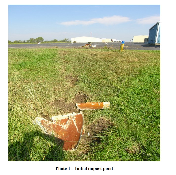
The on-site examination of the wreckage revealed that the airplane impacted terrain and an asphalt ramp just behind a building west of runway 18. Propeller cuts in the asphalt and ground scars were consistent with a right-wing-down, nose-low impact. The right wing had separated from the fuselage and was located about 92 ft from, and west of, the initial impact point. The wreckage path was 305 ft long and proceeded from the initial impact point on a heading of about 340° to the main wreckage, which consisted of the fuselage, left wing, empennage, and engine compartment. The two-bladed propeller had separated from the engine's crankshaft flange and was located about 20 ft beyond the main wreckage. About 8 inches of one propeller blade was torn off, whereas the other blade was severely distorted. There was no postcrash fire.
The airplane's left wing remained with the fuselage but was only partially attached. An undetermined amount of fuel remained in the left- and right-wing fuel tanks. An area near the right wing showed evidence of a fuel spill.
The main cabin floor and engine firewall were pushed back into the cabin area, and the front, right side of the fuselage had also sustained extensive damage. The top engine cowling was impact separated and was located along the wreckage path. The empennage sustained major damage to the right side of the stabilator.
Left aileron continuity was established from the control surface to the bellcrank; the aileron control and balance cable were attached to the left bellcrank, aileron control wheel chain, and right bellcrank. The right aileron remained attached; however, the control rod was broken, and the bellcrank had separated, pulled through wing ribs, and was found with the fuselage. Rudder control continuity was established to the cockpit rudder pedals. The flap handle was in the retracted position; however, due to damage to the flap controls, the actual position of the flaps during landing could not be determined.
The engine sustained impact damage and was examined on-site by the NTSB and a technical representative from the engine manufacturer. The engine was cut from the airframe and hung by a forklift to aid examination. The bottom set of spark plugs were removed and exhibited light-colored combustion deposits, and the electrodes exhibited normal wear signatures. The engine was rotated by hand; a thumb suction compression test was conducted, and continuity through the engine valve train and accessory section was confirmed. The left and right magnetos were removed from the engine and tested by hand; spark was observed on each terminal. The fuel pump and carburetor were examined, and no abnormalities were noted.
No preimpact abnormalities were noted during the airframe or engine examinations.
Medical And Pathological Information
The Office of the Jackson County Medical Examiner, Kansas City, Missouri, conducted an autopsy on the pilot. The cause of death was determined to be "multiple blunt force injuries."
The Federal Aviation Administration's Bioaeronautical Sciences Research Laboratory, Oklahoma City, Oklahoma, conducted toxicological testing on specimens from the pilot. The tests were negative for ethanol and tested drugs.
NTSB Identification: CEN16FA378
14 CFR Part 91: General Aviation
Accident occurred Tuesday, September 20, 2016 in Lee's Summit, MO
Aircraft: PIPER PA 28-235, registration: N8983W
Injuries: 2 Fatal.
This is preliminary information, subject to change, and may contain errors. Any errors in this report will be corrected when the final report has been completed. NTSB investigators either traveled in support of this investigation or conducted a significant amount of investigative work without any travel, and used data obtained from various sources to prepare this aircraft accident report.
On September 20, 2016, about 1820 central daylight time, a Piper PA-28-235 airplane, N8983W, impacted terrain near Lee's Summit, Missouri. The private rated pilot and passenger were fatally injured, and the airplane was substantially damaged. The airplane was registered to and operated by TEKO Air LLC, Des Moines, Iowa, under the provisions of 14 Code of Federal Regulations Part 91 as a personal fight. Visual meteorological conditions prevailed and no flight plan had been filed. The cross country flight originated from the Ankeny Regional Airport (KIKV), Des Moines, Iowa, and was en route to the Lee's Summit Municipal airport, (KLXT), Lee's Summit, Missouri.
Several witnesses reported seeing segments of the airplane's accident flight. Additionally, several of the airport's security cameras captured a portion of the flight. A review of the security camera video's and witness statements, revealed the airplane touched down on KLXT's runway 18, the airplane then continued on the runway for a little way, before departing. The airplane was then seen with nose high, left wing low attitude. The airplane continued and entered into a right steep turn; one witness reported that the airplane was high as 200 to 300 ft above ground level. The airplane continued to make a 180-degree turn, with a wing bank angle of about 90 degrees. The airplane made a rapid decent, impacting terrain in a right wing, nose low attitude. The airplane then slid along the ramp for about 250 ft, coming to rest on its right side.
After the initial on-site documentation of the wreckage, the airplane was recovered for further examination.

Kelli Brooke Basile

Vincent Louis Basile II


The pilot and one passenger were on a cross-country flight in a single-engine airplane. Review of the airplane's radar flight track revealed that it was on a southerly heading to the destination airport and made a straight-in approach to runway 18. As the airplane neared the airport, a passenger filmed the approach section of the flight using her phone. A review of the footage showed that the approach appeared normal; however, during the landing flare, the airplane drifted slightly right. The camera then recorded the sound of the engine power increasing, followed immediately by the airplane touching down right of the runway centerline. The engine power then increases (likely either for a touch-and-go or for a go-around) and the airplane begins to climb in a right bank. The camera also captured images of the control yoke, which showed the pilot manipulating it aft and turning it left.
Several witnesses also reported seeing segments of the accident flight, and several of the airport's security cameras captured portions of the flight. A review of the videos and witness statements confirmed that the airplane touched down on the runway and then lifted off in a nose-high, right-wing-low attitude. The airplane then entered a steep right climbing turn; one witness reported that the airplane reached about 200 to 300 ft above ground level. The airplane then completed a 180° turn with about a 90° bank angle; entered a rapid descent; impacted terrain in a right-wing-down, nose-low attitude; slid along the ramp; and came to rest on its right side.
An examination of the engine and airframe did not reveal any preimpact abnormalities. Based on the available information, the pilot overcontrolled the airplane during takeoff, which resulted in it exceeding its critical angle of attack that led to an aerodynamic stall and loss of airplane control.
Probable Cause and Findings
The National Transportation Safety Board determines the probable cause(s) of this accident to be:
The pilot's improper control inputs during takeoff, which resulted in the exceedance of the airplane's critical angle of attack and subsequent departure stall, and loss of airplane control.
Findings
Aircraft
Angle of attack - Not attained/maintained (Cause)
Personnel issues
Incorrect action selection - Pilot (Cause)
Aircraft control - Pilot (Cause)
Total experience in position - Pilot
Factual Information
History of Flight
Takeoff
Aerodynamic stall/spin (Defining event)
Loss of control in flight
Kelli Brooke Basile
Vincent Louis Basile II
The National Transportation Safety Board traveled to the scene of this accident.
Additional Participating Entities:
Federal Aviation Administration / Flight Standards District Office; Kansas City, Missouri
Piper Aircraft Company; Vero Beach, Florida
Lycoming Aircraft Engines; Williamsport, Pennsylvania
Aviation Accident Factual Report - National Transportation Safety Board: https://app.ntsb.gov/pdf
Investigation Docket - National Transportation Safety Board: https://dms.ntsb.gov/pubdms
TEKO Air LLC: http://registry.faa.gov/N8983W
Location: Lee's Summit, MO
Accident Number: CEN16FA378
Date & Time: 09/20/2016, 1820 CDT
Registration: N8983W
Aircraft: PIPER PA 28-235
Aircraft Damage: Substantial
Defining Event: Aerodynamic stall/spin
Injuries: 2 Fatal
Flight Conducted Under: Part 91: General Aviation - Personal
On September 20, 2016, about 1820 central daylight time, a Piper PA-28-235 airplane, N8983W, impacted terrain near Lee's Summit, Missouri. The pilot and passenger were fatally injured, and the airplane was substantially damaged. The airplane was registered to and operated by TEKO Air, LLC, Des Moines, Iowa, as a 14 Code of Federal Regulations Part 91 personal fight. Visual meteorological conditions existed near the accident site about the time of the accident, and no flight plan had been filed. The cross-country flight originated from Ankeny Regional Airport, Des Moines, Iowa, and was en route to Lee's Summit Municipal Airport (KLXT), Lee's Summit, Missouri.
A review of the airplane's radar flight track revealed that the airplane was on a southernly heading to KLXT and then made a straight-in approach to runway 18. As the airplane neared KLXT, a passenger filmed the approach section of the flight using her phone, which was found on scene. The camera captured portions of the approach to the runway. The approach appeared normal; however, during the landing flare, the airplane drifted slightly right. The camera then recorded the sound of the engine power increasing, followed immediately by the airplane touching down right of the runway centerline. The camera captured images of the control yoke, which showed the pilot manipulating it aft and turning it left. The sound was consistent with the engine at high power until the end of the recording. The National Transportation Safety Board's (NTSB) Personal Electronic Device Specialist's Factual Report is located in the docket for this accident.
Several witnesses reported seeing segments of the accident flight. Additionally, several of the airport's security cameras captured portions of the flight. A review of the security camera videos and witness statements revealed that the airplane touched down on runway 18 and then lifted off in a nose-high, right-wing-low attitude. The airplane then made a steep, right climbing turn; one witness reported that the airplane reached about 200 to 300 ft above ground level. The airplane completed a 180° turn with about a 90° bank angle and then entered a rapid descent, impacted terrain in a right-wing-down, nose-low attitude, slid along the ramp, and came to rest on its right side.

Pilot Information
Certificate: Private
Age: 53
Airplane Rating(s): Single-engine Land
Seat Occupied: Left
Other Aircraft Rating(s): None
Restraint Used: Lap Only
Instrument Rating(s): None
Second Pilot Present: No
Instructor Rating(s): None
Toxicology Performed: Yes
Medical Certification: Class 3 With Waivers/Limitations
Last FAA Medical Exam: 09/28/2015
Occupational Pilot: No
Last Flight Review or Equivalent:
Flight Time: 92.3 hours (Total, all aircraft), 64.1 hours (Total, this make and model)
The pilot held a private pilot certificate, which was issued on June 9, 2016, with an airplane single-engine land rating. Additionally, he held a control tower operator certificate. The pilot was issued a third-class medical certificate on Sept 29, 2015. A review of the pilot's logbook revealed that he had 92.3 total flight hours, 18.2 hours of which were accrued since the pilot certificate was issued, with the last entry dated September 14, 2016.
Aircraft and Owner/Operator Information
Aircraft Manufacturer: PIPER
Registration: N8983W
Model/Series: PA 28-235 235
Aircraft Category: Airplane
Year of Manufacture: 1964
Amateur Built: No
Airworthiness Certificate: Normal
Serial Number: 28-10562
Landing Gear Type: Tricycle
Seats:
Date/Type of Last Inspection: 12/31/2015, Annual
Certified Max Gross Wt.:
Time Since Last Inspection:
Engines: 1 Reciprocating
Airframe Total Time: 2883.6 Hours at time of accident
Engine Manufacturer: LYCOMING
ELT: C91 installed, not activated
Engine Model/Series: 0-540 SERIES
Registered Owner: TEKO Air LLC
Rated Power: 250 hp
Operator: TEKO Air LLC
Operating Certificate(s) Held: None
The accident airplane was a Piper PA-28-235, which is a low-wing, single-engine airplane with fixed landing gear. It was powered by a reciprocating 235-horsepower Lycoming, six-cylinder engine that drove a fixed-pitch propeller. A review of the airplane's maintenance records revealed that the last annual inspection was conducted on December 31, 2015, at a total time of 2,780.32 hours. A review of the engine maintenance records revealed that the engine was removed, overhauled, and reinstalled on August 22, 2016, at an airframe tachometer time of 2,822.2 hours. The tachometer read 2,883.6 hours at the accident site.
Meteorological Information and Flight Plan
Conditions at Accident Site: Visual Conditions
Condition of Light: Day
Observation Facility, Elevation: KLXT
Observation Time: 1753 CDT
Distance from Accident Site:
Direction from Accident Site:
Lowest Cloud Condition: Clear
Temperature/Dew Point: 32°C / 23°C
Lowest Ceiling: None
Visibility: 10 Miles
Wind Speed/Gusts, Direction: 10 knots, 190°
Visibility (RVR):
Altimeter Setting: 30.04 inches Hg
Visibility (RVV):
Precipitation and Obscuration: No Precipitation
Departure Point: Ankeny, IA (KIKV)
Type of Flight Plan Filed: None
Destination: Lee's Summit, MO (KLXT)
Type of Clearance: VFR Flight Following
Departure Time:
Type of Airspace:
At 1853, the weather observation facility at KLXT recorded wind from 190° at 10 knots, 10 miles visibility, clear sky, temperature 90°F, dew point 73°F, and an altimeter setting of 30.04 inches of mercury.
Airport Information
Airport: Lee's Summit (KLXT)
Runway Surface Type: Asphalt
Airport Elevation: 1004 ft
Runway Surface Condition: Dry
Runway Used: 18
IFR Approach: None
Runway Length/Width: 4016 ft / 75 ft
VFR Approach/Landing: Straight-in
KLXT is a publicly owned, nontowered airport located 3 miles north of Lee's Summit, Missouri. Pilots are to use the common traffic advisory frequency for communications. KLXT has two concrete runways 18/36, which is 4,016 ft by 75 ft, and 11/29, which is 3,800 ft by 75 ft. The airport is at an elevation of 1,004 ft mean sea level.
Wreckage and Impact Information
Crew Injuries: 1 Fatal
Aircraft Damage: Substantial
Passenger Injuries: 1 Fatal
Aircraft Fire: None
Ground Injuries: N/A
Aircraft Explosion: None
Total Injuries: 2 Fatal
Latitude, Longitude: 38.960556, -94.375556
The on-site examination of the wreckage revealed that the airplane impacted terrain and an asphalt ramp just behind a building west of runway 18. Propeller cuts in the asphalt and ground scars were consistent with a right-wing-down, nose-low impact. The right wing had separated from the fuselage and was located about 92 ft from, and west of, the initial impact point. The wreckage path was 305 ft long and proceeded from the initial impact point on a heading of about 340° to the main wreckage, which consisted of the fuselage, left wing, empennage, and engine compartment. The two-bladed propeller had separated from the engine's crankshaft flange and was located about 20 ft beyond the main wreckage. About 8 inches of one propeller blade was torn off, whereas the other blade was severely distorted. There was no postcrash fire.
The airplane's left wing remained with the fuselage but was only partially attached. An undetermined amount of fuel remained in the left- and right-wing fuel tanks. An area near the right wing showed evidence of a fuel spill.
The main cabin floor and engine firewall were pushed back into the cabin area, and the front, right side of the fuselage had also sustained extensive damage. The top engine cowling was impact separated and was located along the wreckage path. The empennage sustained major damage to the right side of the stabilator.
Left aileron continuity was established from the control surface to the bellcrank; the aileron control and balance cable were attached to the left bellcrank, aileron control wheel chain, and right bellcrank. The right aileron remained attached; however, the control rod was broken, and the bellcrank had separated, pulled through wing ribs, and was found with the fuselage. Rudder control continuity was established to the cockpit rudder pedals. The flap handle was in the retracted position; however, due to damage to the flap controls, the actual position of the flaps during landing could not be determined.
The engine sustained impact damage and was examined on-site by the NTSB and a technical representative from the engine manufacturer. The engine was cut from the airframe and hung by a forklift to aid examination. The bottom set of spark plugs were removed and exhibited light-colored combustion deposits, and the electrodes exhibited normal wear signatures. The engine was rotated by hand; a thumb suction compression test was conducted, and continuity through the engine valve train and accessory section was confirmed. The left and right magnetos were removed from the engine and tested by hand; spark was observed on each terminal. The fuel pump and carburetor were examined, and no abnormalities were noted.
No preimpact abnormalities were noted during the airframe or engine examinations.
Medical And Pathological Information
The Office of the Jackson County Medical Examiner, Kansas City, Missouri, conducted an autopsy on the pilot. The cause of death was determined to be "multiple blunt force injuries."
The Federal Aviation Administration's Bioaeronautical Sciences Research Laboratory, Oklahoma City, Oklahoma, conducted toxicological testing on specimens from the pilot. The tests were negative for ethanol and tested drugs.
NTSB Identification: CEN16FA378
14 CFR Part 91: General Aviation
Accident occurred Tuesday, September 20, 2016 in Lee's Summit, MO
Aircraft: PIPER PA 28-235, registration: N8983W
Injuries: 2 Fatal.
This is preliminary information, subject to change, and may contain errors. Any errors in this report will be corrected when the final report has been completed. NTSB investigators either traveled in support of this investigation or conducted a significant amount of investigative work without any travel, and used data obtained from various sources to prepare this aircraft accident report.
On September 20, 2016, about 1820 central daylight time, a Piper PA-28-235 airplane, N8983W, impacted terrain near Lee's Summit, Missouri. The private rated pilot and passenger were fatally injured, and the airplane was substantially damaged. The airplane was registered to and operated by TEKO Air LLC, Des Moines, Iowa, under the provisions of 14 Code of Federal Regulations Part 91 as a personal fight. Visual meteorological conditions prevailed and no flight plan had been filed. The cross country flight originated from the Ankeny Regional Airport (KIKV), Des Moines, Iowa, and was en route to the Lee's Summit Municipal airport, (KLXT), Lee's Summit, Missouri.
Several witnesses reported seeing segments of the airplane's accident flight. Additionally, several of the airport's security cameras captured a portion of the flight. A review of the security camera video's and witness statements, revealed the airplane touched down on KLXT's runway 18, the airplane then continued on the runway for a little way, before departing. The airplane was then seen with nose high, left wing low attitude. The airplane continued and entered into a right steep turn; one witness reported that the airplane was high as 200 to 300 ft above ground level. The airplane continued to make a 180-degree turn, with a wing bank angle of about 90 degrees. The airplane made a rapid decent, impacting terrain in a right wing, nose low attitude. The airplane then slid along the ramp for about 250 ft, coming to rest on its right side.
After the initial on-site documentation of the wreckage, the airplane was recovered for further examination.

Kelli Basile
Two people killed in a plane crash in Missouri on Tuesday were from the Des Moines metro area.
The pilot, Vincent Basile, 53, of Des Moines, and the passenger Kelli Basile, 24, of West Des Moines, were traveling from Des Moines to Lee's Summit, Mo., to visit family, according to a news release.
Kelli Basile was working at Grant Ragan Elementary School as a special education associate, according to Nicole Lawrence, spokeswoman for the Waukee school district. She started working for the district in 2015.
"Our thoughts and prayers are with the family and friends of Kelli," Lawrence said. "Our grief response team has been activated, and counselors are available for students and staff. It is important that we all support each other during this time of grief and loss."
Kelli Basile graduated from Valley High School in West Des Moines in 2010 and Iowa State University in 2014. She also worked for i9 Sports, a youth sports organization. She was engaged to be married next summer.
"There are no words for a tragedy like this," said Anna Swanson, who knew Basile both in high school and college. "Kelli was, and will always be, such a bright light."
Around 6 p.m., emergency officials responded to a a single-engine plane crash at the Lee's Summit airport in Missouri, according to Sgt. Chris Depue, spokesman for Lee's Summit police. The Lee’s Summit airport is not towered, meaning there is no tower for pilots to communicate with.
The airplane was a 1964 Piper PA-28-235, which is a four-seat, low-wing and fixed-gear general aviation aircraft.
When officers arrived, they found a plane on the west side of the airport on the tarmac. Both people on board were killed in the crash. Investigators with the Lee's Summit Police Department are working with the Federal Aviation Administration to determine where the flight originated from and what led to the crash.
Peter Knudson, spokesman for National Transportation Safety Board, said there were witnesses to the crash who might be able to shed more light about what happened throughout the investigation. He said there was no fire following the crash, but a wing did separate from the plane.
Knudson also said it's still unknown whether the crash happened while Basile was trying to land. He said accidents and fatalities occur more frequently with smaller planes compared to commercial aircraft.
Knudson could not confirm whether Lee's Summit was the plane's intended destination or whether the crash was a result of an emergency landing.
The plane was registered to Teko Air LLC in Des Moines, according to FAA records. Calls to the company were not immediately answered.
Vince Basile was a licensed pilot, qualified to fly a single-engine airplane, like the one that crashed, according to FAA records.
Reached by phone Wednesday evening, a member of the Basile family declined to comment.
Source: http://www.desmoinesregister.com
KANSAS CITY, Mo. —Two people have died in a small plane crash at the Lee's Summit Municipal Airport.
The plane crashed about 6:10 p.m. while apparently trying to land at the airport in the 2700 block of Northeast Douglas Street.
Two people have died in a small plane crash at the Lee's Summit Municipal Airport.
MORE
Investigators said crews found the plane at rest on the tarmac, but aerial video from Newschopper 9 appears to show an impact on the edge of the grass.
Sgt. Chris Depue of the Lee's Summit Police Department said there was no indication that the Piper PA-28-235 made any mayday calls or reported any other kinds of trouble.
"Right now, we're working along with the FAA, as well as our criminal investigation division, just to conduct a thorough investigation just to gather those facts, so we have a full understanding of what happened," Depue said.
Police identified the victims as Vincent L. Basile, 53, of Des Moines, Iowa, and Kelli B. Basile, 24, of West Des Moines, Iowa.
The families of the victims were at the airport at the time of the crash.
Crash investigators are trying to determine what happened.
Story and video: http://www.kmbc.com
LEE'S SUMMIT, MO (KCTV) - Police have identified the two victims killed in a plane crash at Lee's Summit Municipal Airport.
According to authorities, Vincent Basile, 53, and Kelli Basile, 24, both of Des Moines, IA were killed in the accident.
Lee's Summit police say the crash happened around 6:10 p.m. Tuesday.
The plane came to rest on the west side of the airport on the tarmac.
Police say the two were heading from Des Moines to Lee's Summit to see family
The airplane is a 1964 PIPER PA-28-235 with a fixed wing single engine, according to aircraft registration records.
Teko Air, LLC. out of Des Moines, Iowa is the listed owner of the plane. Records show the plane was purchased in December.
The Lee's Summit Municipal Airport is a non-towered airport, meaning there is no tower to speak with, leaving pilots to tell other pilots what they are doing on a frequency.
Investigators say the airport remains open, as runways were not affected by the crash.
Story and video: http://www.kctv5.com
LEE'S SUMMIT, Mo. - Two people are dead after a plane crashed at Lee’s Summit Municipal Airport Tuesday night.
Lee's Summit police said emergency crews were called to the airport around 6:10 p.m. When they arrived, they found a single-engine plane on the west side of the runways, west of the tarmac area, that tried to make a landing and crashed.
"Our initial investigation says this was their destination. This is where they were heading this evening," said Sgt. Chris Depue of the Lee's Summit Police Department.
41 Action News learned the plane is registered to Teko Air LLC in Des Moines, Iowa. Calls to the number listed for Teko Air were not answered.
Police said there is no indication yet as far as mayday calls or any kind of other troubles.
The FAA is en route. Lee's Summit police are working with the FAA as well as the criminal investigations unit to learn where the flight originated from and what may have caused the crash.
The Lee's Summit Airport is a non-towered airport, meaning pilots have to "see and avoid" when landing and taking off.
The airport remains open for operations.
Story and video: http://www.kshb.com


