Thursday, June 30, 2022

Piper PA-20-135 Pacer, N1231C: Fatal accident occurred June 26, 2022 near Lower Loon Creek Airstrip (C53), Challis, Custer County, Idaho

This is preliminary information, subject to change, and may contain errors. Any errors in this report will be corrected when the final report has been completed. 

The National Transportation Safety Board traveled to the scene of this accident. 

Additional Participating Entity: 
Federal Aviation Administration / Flight Standards District Office; Boise, Idaho


Location: Challis, Idaho
Accident Number: WPR22LA238
Date and Time: June 26, 2022, 19:45 Local 
Registration: N1231C
Aircraft: Piper PA-20-135 
Injuries: 2 Fatal
Flight Conducted Under: Part 91: General aviation - Personal

On June 26, 2022, about 1945 mountain daylight time, a Piper PA-20-135, N1231C, was substantially damaged when it was involved in an accident near Challis, Idaho. The pilot and passenger were fatally injured. The airplane was operated as a Title 14 Code of Federal Regulations Part 91 personal flight.

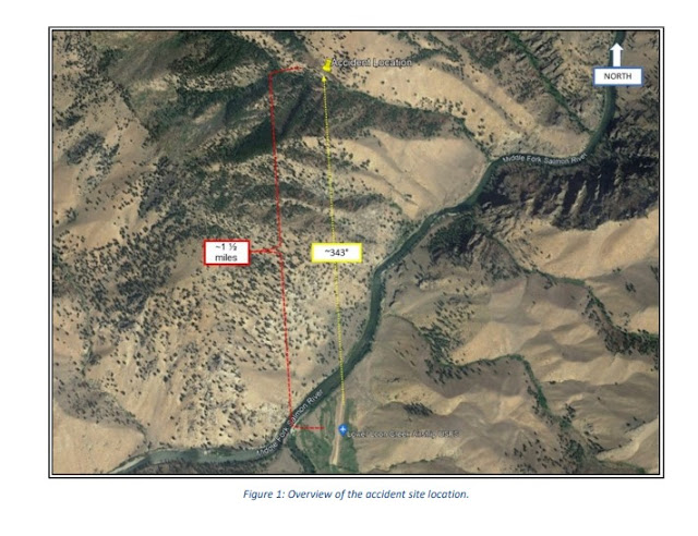
A friend of the pilot reported that he and the accident pilot were camping at Johnson Creek (3U2), Yellow Pine, Idaho. Earlier in the day they had flown to Lower Loon Creek Airstrip (C53), Challis, Idaho, and due to the density altitude, they waited to depart from C53 until later that evening for the return flight to 3U2. He further added that at the time of departure, the density altitude was indicating about 6,200 ft. He observed the accident airplane depart to the north, climb, and then turn back toward the runway about 1930. He last observed the accident airplane on a southbound heading. Shortly after departing from C53, he observed smoke, which he believed to be a small ground fire. After landing and refueling at McCall Municipal Airport (KMYL), he continued his flight to 3U2 where he expected to meet with the accident pilot and passenger. They had not arrived, and he reported N1231C as missing. First responders located the airplane wreckage by air the following day about 1 ½ miles north of C53. On June 28, they accessed the accident site and reported that the airplane had impacted steep rising mountainous terrain at an elevation of about 4,200 ft mean sea level (msl) on an approximate southerly heading. The main wreckage came to rest upright about 30 ft below the first identified point of impact and was mostly consumed by fire. All major structural components of the airplane were observed at the accident site.

The wreckage was recovered to a secure location for further examination.


Aircraft and Owner/Operator Information

Aircraft Make: Piper
Registration: N1231C
Model/Series: PA-20-135 
Aircraft Category: Airplane
Amateur Built:
Operator:
Operating Certificate(s) Held: None
Operator Designator Code:

Meteorological Information and Flight Plan

Conditions at Accident Site: VMC
Condition of Light: Dusk
Observation Facility, Elevation: KLLJ, 5040 ft msl 
Observation Time: 19:55 Local
Distance from Accident Site: 32 Nautical Miles
Temperature/Dew Point: 30°C /-2°C
Lowest Cloud Condition: Clear 
Wind Speed/Gusts, Direction: / ,
Lowest Ceiling: None 
Visibility: 10 miles
Altimeter Setting: 30.21 inches Hg
Type of Flight Plan Filed: None
Departure Point: Challis, ID (C53)
Destination: Yellow Pine, ID (3U2)

Wreckage and Impact Information

Crew Injuries: 1 Fatal
Aircraft Damage: Substantial
Passenger Injuries: 1 Fatal
Aircraft Fire: Fire at unknown time
Ground Injuries: 
Aircraft Explosion: None
Total Injuries: 2 Fatal
Latitude, Longitude: 44.822667,-114.82533

Those who may have information that might be relevant to the National Transportation Safety Board (NTSB) investigation may contact them by email witness@ntsb.gov, and any friends and family who want to contact investigators about the accident should email assistance@ntsb.gov. You can also call the NTSB Response Operations Center at 844-373-9922 or 202-314-6290. 

Aircraft crashed under unknown circumstances. 

Date: 27-JUN-22
Time: 01:45:00Z
Regis#: N1231C
Aircraft Make: PIPER
Aircraft Model: PA20
Event Type: ACCIDENT
Highest Injury: FATAL
Total Fatal: 2
Flight Crew: 1
Pax: 1
Activity: PERSONAL
Flight Phase: EN ROUTE (ENR)
Operation: 91
Aircraft Missing: No
Damage: SUBSTANTIAL
City: CHALLIS
State: IDAHO

Beech A36 Bonanza, N44ZM: Incident occurred June 29, 2022 at Perryville Regional Airport (KPCD), Perry County, Missouri

Federal Aviation Administration / Flight Standards District Office; St. Louis, Missouri

Aircraft landed gear up.  


Date: 29-JUN-22
Time: 16:00:00Z
Regis#: N44ZM
Aircraft Make: BEECH
Aircraft Model: A36
Event Type: INCIDENT
Highest Injury: NONE
Aircraft Missing: No
Damage: MINOR
Activity: PERSONAL
Flight Phase: LANDING (LDG)
Operation: 91
City: PERRYVILLE
State: MISSOURI

Piper PA-32RT-300 Lance II, N4321M: Incident occurred June 29, 2022 at Pilots Ridge Airport (03NC), Carolina Beach, New Hanover County, North Carolina

Federal Aviation Administration / Flight Standards District Office; Greensboro, North Carolina

Aircraft aborted takeoff, ran off the runway and went into a retention pond. 


Date: 29-JUN-22
Time: 15:43:00Z
Regis#: N4321M
Aircraft Make: PIPER
Aircraft Model: PA32RT
Event Type: INCIDENT
Highest Injury: NONE
Aircraft Missing: No
Damage: UNKNOWN
Activity: PERSONAL
Flight Phase: TAKEOFF (TOF)
Operation: 91
City: CAROLINA BEACH
State: NORTH CAROLINA

Van's RV-7A, N358MG: Incident occurred June 29, 2022 at Weltzien Skypark Airport (15G), Wadsworth, Medina County, Ohio

Federal Aviation Administration / Flight Standards District Office; Cleveland, Ohio

Aircraft on landing, ran through guardrail and flipped over.


Date: 29-JUN-22
Time: 19:00:00Z
Regis#: N358MG
Aircraft Make: VANS
Aircraft Model: RV7
Event Type: INCIDENT
Highest Injury: MINOR
Aircraft Missing: No
Damage: UNKNOWN
Activity: PERSONAL
Flight Phase: LANDING (LDG)
Operation: 91
City: WADSWORTH
State: OHIO

Van's RV-6A, N18390: Incident occurred June 19, 2022 at Paradise Air Haven Airport (39OK), Goldsby, McClain County, Oklahoma

Federal Aviation Administration / Flight Standards District Office; Oklahoma City, Oklahoma

Aircraft ran off runway into trees. 


Date: 19-JUN-22
Time: 20:00:00Z
Regis#: N18390
Aircraft Make: VANS
Aircraft Model: RV6
Event Type: INCIDENT
Highest Injury: NONE
Aircraft Missing: No
Damage: UNKNOWN
Activity: PERSONAL
Flight Phase: LANDING (LDG)
Operation: 91
City: GOLDSBY
State: OKLAHOMA

AMS-Flight Carat A, N30PF: Incident occurred June 29, 2022 at Morrisville-Stowe State Airport (KMVL), Lamoille County, Vermont

Federal Aviation Administration / Flight Standards District Office; Portland, Maine

Motorglider landed gear up. 

PSF Associates LLC


Date: 29-JUN-22
Time: 19:03:00Z
Regis#: N30PF
Aircraft Make: AMS FLIGHT
Aircraft Model: CARAT A
Event Type: INCIDENT
Highest Injury: NONE
Aircraft Missing: No
Damage: UNKNOWN
Activity: PERSONAL
Flight Phase: LANDING (LDG)
Operation: 91
City: MORRISVILLE
State: VERMONT

Wednesday, June 29, 2022

Cessna 208 Caravan I, N265KP: Accident occurred June 26, 2022 at Elfin Cove Seaplane Base (PAEL), Alaska

This is preliminary information, subject to change, and may contain errors. Any errors in this report will be corrected when the final report has been completed. 

The National Transportation Safety Board did not travel to the scene of this accident. 

Additional Participating Entity: 
Federal Aviation Administration / Flight Standards District Office; Juneau, Alaska

Alaska Seaplanes

Kalinin Partners LLC


Location: Elfin Cove, Alaska
Accident Number: ANC22LA048
Date and Time: June 26, 2022, 11:45 Local 
Registration: N265KP
Aircraft: Cessna 208 
Injuries: 8 None
Flight Conducted Under: Part 135: Air taxi & commuter - Scheduled

Aircraft and Owner/Operator Information

Aircraft Make: Cessna
Registration: N265KP
Model/Series: 208 
Aircraft Category: Airplane
Amateur Built:
Operator: 
Operating Certificate(s) Held: Commuter air carrier (135)
Operator Designator Code:

Meteorological Information and Flight Plan

Conditions at Accident Site: VMC
Condition of Light: Day
Observation Facility, Elevation: PAGS,30 ft msl
Observation Time: 11:56 Local
Distance from Accident Site: 26 Nautical Miles
Temperature/Dew Point: 18°C /12°C
Lowest Cloud Condition: Clear 
Wind Speed/Gusts, Direction: 8 knots / , 210°
Lowest Ceiling: None
Visibility: 10 miles
Altimeter Setting: 30.28 inches Hg
Type of Flight Plan Filed:
Departure Point: Elfin Cove, AK
Destination: Juneau, AK

Wreckage and Impact Information

Crew Injuries: 1 None 
Aircraft Damage: Substantial
Passenger Injuries: 7 None
Aircraft Fire: None
Ground Injuries: 
Aircraft Explosion: None
Total Injuries: 8 None 
Latitude, Longitude: 58.127212,-136.31496 

Aircraft lost directional control on takeoff and pontoon struck beach.  

Date: 26-JUN-22
Time: 19:45:00Z
Regis#: N265KP
Aircraft Make: CESSNA
Aircraft Model: 208
Event Type: ACCIDENT
Highest Injury: NONE
Aircraft Missing: No
Damage: SUBSTANTIAL
Activity: ON DEMAND
Flight Phase: TAKEOFF (TOF)
Operation: 135
Aircraft Operator: KALININ AVIATION
City: ELFIN COVE
State: ALASKA

de Havilland Canada U-6A Beaver, N600NL: Accident occurred June 25, 2022 in Kokhanok, Alaska

This is preliminary information, subject to change, and may contain errors. Any errors in this report will be corrected when the final report has been completed. 

The National Transportation Safety Board did not travel to the scene of this accident. 

Additional Participating Entity: 
Federal Aviation Administration / Flight Standards District Office; Anchorage, Alaska

Newhalen Lodge Inc


Location: Kokhanok, Alaska
Accident Number: ANC22LA050
Date and Time: June 25, 2022, 18:00 Local
Registration: N600NL
Aircraft: DEHAVILLAND BEAVER U-6A 
Injuries: 7 None
Flight Conducted Under: Part 91: General aviation - Business

Aircraft and Owner/Operator Information

Aircraft Make: DEHAVILLAND 
Registration: N600NL
Model/Series: BEAVER U-6A 
Aircraft Category: Airplane
Amateur Built:
Operator: 
Operating Certificate(s) Held: None
Operator Designator Code:

Meteorological Information and Flight Plan

Conditions at Accident Site: VMC 
Condition of Light: Day
Observation Facility, Elevation: PAIL,160 ft msl
Observation Time: 17:53 Local
Distance from Accident Site: 19 Nautical Miles 
Temperature/Dew Point: 14°C /10°C
Lowest Cloud Condition: Clear 
Wind Speed/Gusts, Direction: 6 knots / , 150°
Lowest Ceiling: None
Visibility: 10 miles
Altimeter Setting: 30.27 inches Hg 
Type of Flight Plan Filed: Company VFR
Departure Point: Kokhanok, AK
Destination: Kokhanok, AK

Wreckage and Impact Information

Crew Injuries: 1 None
Aircraft Damage: Substantial
Passenger Injuries: 6 None
Aircraft Fire: None
Ground Injuries: 
Aircraft Explosion: None
Total Injuries: 7 None 
Latitude, Longitude: 59.439361,-154.7681 

Aircraft crashed under unknown circumstances into a lake and flipped over. 

Date: 26-JUN-22
Time: 02:20:00Z
Regis#: N600NL
Aircraft Make: DEHAVILLAND
Aircraft Model: BEAVER U-6A
Event Type: ACCIDENT
Highest Injury: MINOR
Aircraft Missing: No
Damage: SUBSTANTIAL
Activity: UNKNOWN
Flight Phase: EN ROUTE (ENR)
City: KOKHANOK
State: Alaska

Champion 7GCBC, N3085G: Accident occurred June 24, 2022 in Palmer, Alaska

This is preliminary information, subject to change, and may contain errors. Any errors in this report will be corrected when the final report has been completed.

The National Transportation Safety Board did not travel to the scene of this accident. 

Additional Participating Entity:
Federal Aviation Administration / Flight Standards District Office; Fairbanks, Alaska


Location: Palmer, Alaska
Accident Number: ANC22LA051
Date and Time: June 24, 2022, 11:30 Local
Registration: N3085G
Aircraft: Champion 7GCBC
Injuries: 1 None
Flight Conducted Under: Part 91: General aviation - Personal

Aircraft and Owner/Operator Information

Aircraft Make: Champion
Registration: N3085G
Model/Series: 7GCBC
Aircraft Category: Airplane
Amateur Built:
Operator: On file
Operating Certificate(s) Held: None
Operator Designator Code:

Meteorological Information and Flight Plan

Conditions at Accident Site: VMC
Condition of Light: Day
Observation Facility, Elevation: PAAQ, 233 ft msl 
Observation Time: 11:53 Local
Distance from Accident Site: 33 Nautical Miles
Temperature/Dew Point: 21°C /11°C
Lowest Cloud Condition: Clear
Wind Speed/Gusts, Direction: 6 knots / , 200°
Lowest Ceiling: None 
Visibility: 10 miles
Altimeter Setting: 30.31 inches Hg
Type of Flight Plan Filed: None
Departure Point: Talkeetna, AK (51AK) 
Destination: Willow, AK (PAUO)

Wreckage and Impact Information

Crew Injuries: 1 None 
Aircraft Damage: Substantial
Passenger Injuries: 
Aircraft Fire: None
Ground Injuries: 
Aircraft Explosion: None
Total Injuries: 1 None
Latitude, Longitude: 62.18,-148.38

Aircraft attempting an off-airport landing and bounced. 

Date: 24-JUN-22
Time: 19:30:00Z
Regis#: N3085G
Aircraft Make: CHAMPION
Aircraft Model: 7GCBC
Event Type: ACCIDENT
Highest Injury: NONE
Aircraft Missing: No
Damage: SUBSTANTIAL
Activity: PERSONAL
Flight Phase: LANDING (LDG)
Operation: 91
City: CHICKALOON
State: ALASKA

Piper PA-14 Family Cruiser, N1423P: Accident occurred June 24, 2022; Incident occurred July 05, 2019; Accident occurred May 19, 2018

Federal Aviation Administration / Flight Standards International Field Office; Los Angeles

June 24, 2022: Aircraft crashed under unknown circumstances in Lillooet, British Columbia.

Kanakanak Fisheries Inc


Date: 24-JUN-22
Time: 05:54:00Z
Regis#: N1423P
Aircraft Make: PIPER
Aircraft Model: PA14
Event Type: ACCIDENT
Highest Injury: SERIOUS
Aircraft Missing: No
Damage: UNKNOWN
Activity: PERSONAL
Flight Phase: EN ROUTE (ENR)
City: LILLOOET
State: BRITISH COLUMBIA
Country: CANADA

Federal Aviation Administration / Flight Standards District Office; Anchorage, Alaska

July 05, 2019:  Aircraft landed hard at  Dillingham Airport  (PADL), Alaska
.

https://registry.faa.gov/N1423P

Date: 05-JUL-19
Time: 18:29:00Z
Regis#: N1423P
Aircraft Make: PIPER
Aircraft Model: PA14
Event Type: INCIDENT
Highest Injury: NONE
Aircraft Missing: No
Damage: UNKNOWN
Activity: PERSONAL
Flight Phase: LANDING (LDG)
Operation: 91
City: DILLINGHAM
State: ALASKA

May 19, 2018


Aviation Accident Final Report - National Transportation Safety Board

The National Transportation Safety Board did not travel to the scene of this accident.

Additional Participating Entity:
Federal Aviation Administration / Flight Standards District Office; Seattle, Washington

Investigation Docket - National Transportation Safety Board:


Location: Vashon, WA
Accident Number: GAA18CA290
Date & Time: 05/19/2018, 2000 PDT
Registration: N1423P
Aircraft: PIPER PA 14
Aircraft Damage: Substantial
Defining Event: Loss of control on ground
Injuries: 2 None
Flight Conducted Under: Part 91: General Aviation - Personal

Analysis

According to the pilot in the tailwheel-equipped airplane, his right foot inadvertently applied pressure to both rudder pedals during the takeoff roll. The airplane exited the left side of the runway, and the left wing struck a tree. The airplane ground looped to the left, and the right wingtip struck the ground.

The airplane sustained substantial damage to the right wing, elevator, and rudder.

The pilot reported that there were no mechanical malfunctions or failures with the airplane that would have precluded normal operation.

Probable Cause and Findings

The National Transportation Safety Board determines the probable cause(s) of this accident to be:
The pilot's failure to maintain directional control of the airplane during the takeoff roll due to his right foot inadvertently applying pressure to both rudder pedals.

Findings

Personnel issues Aircraft control - Pilot
Aircraft Rudder control system - Unintentional use/operation
Aircraft Directional control - Not attained/maintained

Factual Information

History of Flight

Takeoff Miscellaneous/other
Takeoff Loss of control on ground (Defining event)
Takeoff Runway excursion
Takeoff Collision with terr/obj (non-CFIT)

Pilot Information

Certificate: Private
Age: 72, Male
Airplane Rating(s): Single-engine Land
Seat Occupied: Left
Other Aircraft Rating(s): Glider
Restraint Used: 4-point
Instrument Rating(s): None
Second Pilot Present: No
Instructor Rating(s): None
Toxicology Performed: No
Medical Certification: Class 3 With Waivers/Limitations
Last FAA Medical Exam: 05/25/2016
Occupational Pilot: No
Last Flight Review or Equivalent: 05/12/2016
Flight Time:   (Estimated) 868.3 hours (Total, all aircraft), 167 hours (Total, this make and model), 868.3 hours (Pilot In Command, all aircraft), 21 hours (Last 90 days, all aircraft), 18.5 hours (Last 30 days, all aircraft), 2.2 hours (Last 24 hours, all aircraft) 

Aircraft and Owner/Operator Information

Aircraft Make: PIPER
Registration: N1423P
Model/Series: PA 14 NO SERIES
Aircraft Category: Airplane
Year of Manufacture: 1948
Amateur Built: No
Airworthiness Certificate: Normal
Serial Number: 1423
Landing Gear Type: Tailwheel
Seats: 4
Date/Type of Last Inspection: 05/01/2018, Annual
Certified Max Gross Wt.: 1935 lbs
Time Since Last Inspection:
Engines: 1 Reciprocating
Airframe Total Time:  as of last inspection
Engine Manufacturer: Lycoming
ELT: C126 installed, activated, aided in locating accident
Engine Model/Series: O-320-A2B
Registered Owner: KANAKANAK FISHERIES INC.
Rated Power: 150 hp
Operator: KANAKANAK FISHERIES INC.
Operating Certificate(s) Held: None

Meteorological Information and Flight Plan

Conditions at Accident Site: Visual Conditions
Condition of Light: Night
Observation Facility, Elevation: KSEA, 434 ft msl
Distance from Accident Site: 7 Nautical Miles
Observation Time: 0253 UTC
Direction from Accident Site: 97°
Lowest Cloud Condition:
Visibility:  10 Miles
Lowest Ceiling: Broken / 3500 ft agl
Visibility (RVR):
Wind Speed/Gusts: 5 knots /
Turbulence Type Forecast/Actual: / None
Wind Direction: 270°
Turbulence Severity Forecast/Actual: / N/A
Altimeter Setting: 29.95 inches Hg
Temperature/Dew Point: 18°C / 16°C
Precipitation and Obscuration: No Obscuration; No Precipitation
Departure Point: Vashon, WA (2S1)
Type of Flight Plan Filed: VFR
Destination: Vashon, WA (2S1)
Type of Clearance: None
Departure Time: 2000 PDT
Type of Airspace: Class G

Airport Information

Airport: VASHON MUNI (2S1)
Runway Surface Type: Grass/turf
Airport Elevation: 316 ft
Runway Surface Condition: Wet 
Runway Used: 17
IFR Approach: None
Runway Length/Width: 2001 ft / 60 ft
VFR Approach/Landing: None

Wreckage and Impact Information

Crew Injuries: 1 None
Aircraft Damage: Substantial
Passenger Injuries: 1 None
Aircraft Fire: None
Ground Injuries: N/A
Aircraft Explosion: None
Total Injuries: 2 None
Latitude, Longitude: 47.458611, -122.476944 (est)

Cub Crafters CC11 Carbon Cub, N594SR: Accident occurred June 26, 2022 at Gillespie Field Airport (KSEE), El Cajon, San Diego County, California

This is preliminary information, subject to change, and may contain errors. Any errors in this report will be corrected when the final report has been completed. 

The National Transportation Safety Board did not travel to the scene of this accident. 

Additional Participating Entity:
Federal Aviation Administration / Flight Standards District Office; San Diego, California


Location: El Cajon, California
Accident Number: WPR22LA230
Date and Time: June 26, 2022, 10:19 Local 
Registration: N594SR
Aircraft: RICHARD M THUNDER CCX-2000
Injuries: 1 None
Flight Conducted Under: Part 91: General aviation - Personal

Aircraft and Owner/Operator Information

Aircraft Make: RICHARD M THUNDER
Registration: N594SR
Model/Series: CCX-2000 
Aircraft Category: Airplane
Amateur Built:
Operator: On file
Operating Certificate(s) Held: None
Operator Designator Code:

Meteorological Information and Flight Plan

Conditions at Accident Site: VMC 
Condition of Light: Day
Observation Facility, Elevation: KSEE,387 ft msl
Observation Time: 09:47 Local
Distance from Accident Site: 0 Nautical Miles 
Temperature/Dew Point: 26°C /6°C
Lowest Cloud Condition: Clear
Wind Speed/Gusts, Direction: / ,
Lowest Ceiling: None 
Visibility: 10 miles
Altimeter Setting: 29.98 inches Hg
Type of Flight Plan Filed: None
Departure Point: El Cajon, CA 
Destination: El Cajon , CA

Wreckage and Impact Information

Crew Injuries: 1 None
Aircraft Damage: Substantial
Passenger Injuries:
Aircraft Fire: None
Ground Injuries: 
Aircraft Explosion: None
Total Injuries: 1 None
Latitude, Longitude: 32.826222,-116.97244 (est)

Aircraft landed and ground looped. 

Date: 26-JUN-22
Time: 17:19:00Z
Regis#: N594SR
Aircraft Make: CUBCRAFTERS
Aircraft Model: CCX-2000
Event Type: ACCIDENT
Highest Injury: NONE
Aircraft Missing: No
Damage: SUBSTANTIAL
Activity: PERSONAL
Flight Phase: LANDING (LDG)
Operation: 91
City: EL CAJON
State: CALIFORNIA

Bell 206B JetRanger II, N915B: Accident occurred June 24, 2022 in Atwater, Merced County, California

This is preliminary information, subject to change, and may contain errors. Any errors in this report will be corrected when the final report has been completed.

The National Transportation Safety Board did not travel to the scene of this accident. 

Additional Participating Entity:
Federal Aviation Administration / Flight Standards District Office; Fresno, California

Bettencourt Flying Service Inc


Location: Merced, California 
Accident Number: WPR22LA236
Date and Time: June 24, 2022, 09:05 Local
Registration: N915B
Aircraft: Bell 206B 
Injuries: 1 None
Flight Conducted Under: Part 137: Agricultural

On June 24, 2022, at 0905 Pacific daylight time, a Bell 206 helicopter, N915B, sustained substantial damage when it was involved in an accident near Merced, California. The pilot was not injured. The helicopter was operated as a Title 14 Code of Federal Regulations (CFR) Part 137 agricultural flight.

The pilot reported that he had just performed a 180° turn and was on the spray run, about six feet above ground level (agl), when he felt a vibration. He then felt a “snap” and the helicopter began to rotate left. He applied right pedal and started an autorotation in an attempt to decrease the airspeed. He attempted to perform a run-on landing in the tall corn. Upon touchdown, the helicopter rolled up on its nose and the main rotor blades severed the tail boom.

A Federal Aviation Administration inspector examined the wreckage. The KAflex driveshaft was separated and there were several sheared bolts and pieces of the KAflex located underneath the engine.

The parts were retained for further examination.

Aircraft and Owner/Operator Information

Aircraft Make: Bell 
Registration: N915B
Model/Series: 206B 
Aircraft Category: Helicopter
Amateur Built:
Operator: 
Operating Certificate(s) Held: Agricultural aircraft (137)
Operator Designator Code:

Meteorological Information and Flight Plan

Conditions at Accident Site: VMC 
Condition of Light: Day
Observation Facility, Elevation: KMCE, 153 ft msl
Observation Time: 09:53 Local
Distance from Accident Site: 4 Nautical Miles
Temperature/Dew Point: 31°C /12°C
Lowest Cloud Condition: Clear 
Wind Speed/Gusts, Direction: 5 knots / , 330°
Lowest Ceiling: None 
Visibility: 10 miles
Altimeter Setting: 29.84 inches Hg
Type of Flight Plan Filed: None
Departure Point: Atwater, CA
Destination: Merced, CA

Wreckage and Impact Information

Crew Injuries: 1 None
Aircraft Damage: Substantial
Passenger Injuries:
Aircraft Fire: None
Ground Injuries: 
Aircraft Explosion: None
Total Injuries: 1 None
Latitude, Longitude: 37.286657,-120.59379 (est)


Rotorcraft impacted the ground for unknown reasons. 

Date: 24-JUN-22
Time: 16:27:00Z
Regis#: N915B
Aircraft Make: BELL
Aircraft Model: 206
Event Type: ACCIDENT
Highest Injury: NONE
Aircraft Missing: No
Damage: SUBSTANTIAL
Activity: AERIAL APPLICATION
Flight Phase: MANEUVERING (MNV)
Operation: 137
City: ATWATER
State: CALIFORNIA

Cessna 680A Citation Latitude, N601QS: Incident occurred June 27, 2022 at Zamperini Field Airport (KTOA), Torrance, California

Federal Aviation Administration / Flight Standards District Office; Long Beach, Florida

Aircraft taxiing and right wing struck a fence. 

NetJetsSales Inc


Date: 27-JUN-22
Time: 00:20:00Z
Regis#: N601QS
Aircraft Make: TEXTRON
Aircraft Model: 680
Event Type: INCIDENT
Highest Injury: NONE
Aircraft Missing: No
Damage: MINOR
Activity: ON DEMAND
Flight Phase: TAXI (TXI)
Operation: 135
Aircraft Operator: NETJETS
City: TORRANCE
State: CALIFORNIA

Beech V35 Bonanza, N274S: Incident occurred June 24, 2022 at Venice Municipal Airport (KVNC), Sarasota County, Florida

Federal Aviation Administration / Flight Standards District Office; Tampa, Florida

Aircraft landed gear up. 


Date: 24-JUN-22
Time: 13:05:00Z
Regis#: N274S
Aircraft Make: BEECH
Aircraft Model: V35
Event Type: INCIDENT
Highest Injury: NONE
Aircraft Missing: No
Damage: UNKNOWN
Activity: PERSONAL
Flight Phase: LANDING (LDG)
Operation: 91
City: VENICE
State: FLORIDA

Piper PA-24-250 Comanche, N14FC: Accident occurred June 26, 2022 in Warm Springs, Meriwether County, Georgia

This is preliminary information, subject to change, and may contain errors. Any errors in this report will be corrected when the final report has been completed.

The National Transportation Safety Board traveled to the scene of this accident. 

Additional Participating Entities:
Federal Aviation Administration / Flight Standards District Office; Atlanta, Georgia 
Piper Aircraft; Vero Beach, Florida
Lycoming Engines; Williamsport, Pennsylvania


Location: Warm Springs, Georgia
Accident Number: ERA22LA291
Date and Time: June 26, 2022, 14:10 Local 
Registration: N14FC
Aircraft: Piper PA-24-250 
Injuries: 2 Serious
Flight Conducted Under: Part 91: General aviation - Personal

On June 26, 2022, about 1410 eastern daylight time, a Piper PA-24-250 airplane, N14FC, was substantially damaged when it was involved in an accident near Warm Springs, Georgia. The private pilot and passenger sustained serious injuries. The airplane was operated by the pilot as a personal flight conducted under the provisions of Title 14 Code of Federal Regulations Part 91.

The pilot reported that the instrument flight rules flight departed from St. Pete-Clearwater International Airport (PIE), Clearwater, Florida, about 1150 and proceeded enroute to his home airport of Newnan Coweta County Airport (CCO), Newnan, Georgia. After about 2 hours and 15 minutes enroute, 20 miles south of the destination, the pilot completed an enroute descent from 8,000 ft mean sea level (msl) to 5,000 ft msl. Upon the level off, the engine power was set to 2,300 RPM, however, it abruptly decreased to 1,500 RPM. The pilot reported that the engine did not sputter, but rather it just “rolled back.” He then moved the mixture to rich, ensured the fuel selector was selected to the main tanks, and turned on the electric fuel pump, however, power did not increase. Subsequently, he declared an emergency to air traffic control, and they advised him of the Roosevelt Memorial Airport (5A9), Warm Springs, Georgia behind his flight path.

The pilot completed a left 180° turn and saw the 18-36 runway about 6-7 miles ahead. He reported that he believed he was too high to descend toward the runway at best glide airspeed and started to descend at a faster rate. During the maneuvering toward the runway, the RPM further reduced from 1,500 RPM to 0 RPM and the propeller completely stopped turning. The pilot reported that this significantly increased the rate of descent, and it became clear that his glide path toward the runway would no longer be sufficient to reach the runway. He recalled maneuvering toward a road, however, the airplane impacted a wooded area about 1.5 miles north of runway 18, which resulted in substantial damage to the fuselage and wings.

The airplane was retained for further examination.

Aircraft and Owner/Operator Information

Aircraft Make: Piper 
Registration: N14FC
Model/Series: PA-24-250 NO SERIES
Aircraft Category: Airplane
Amateur Built:
Operator: On file 
Operating Certificate(s) Held: None
Operator Designator Code:

Meteorological Information and Flight Plan

Conditions at Accident Site: VMC
Condition of Light: Day
Observation Facility, Elevation: CCO,970 ft msl
Observation Time: 14:15 Local
Distance from Accident Site: 21 Nautical Miles 
Temperature/Dew Point: 30°C /19°C
Lowest Cloud Condition: Scattered / 4200 ft AGL
Wind Speed/Gusts, Direction: / ,
Lowest Ceiling: 
Visibility: 10 miles
Altimeter Setting: 30.14 inches Hg 
Type of Flight Plan Filed: IFR
Departure Point: Clearwater, FL (PIE) 
Destination: Newnan, GA (CCO)

Wreckage and Impact Information

Crew Injuries: 1 Serious
Aircraft Damage: Substantial
Passenger Injuries: 1 Serious 
Aircraft Fire: None
Ground Injuries: 
Aircraft Explosion: None
Total Injuries: 2 Serious 
Latitude, Longitude: 32.971525,-84.697594 (est)

Aircraft departed, experienced engine issues and made an emergency landing in a field. 

Date: 26-JUN-22
Time: 18:15:00Z
Regis#: N14FC
Aircraft Make: PIPER
Aircraft Model: PA24
Event Type: INCIDENT
Highest Injury: SERIOUS
Aircraft Missing: No
Damage: UNKNOWN
Activity: PERSONAL
Operation: 91
City: WARM SPRINGS
State: GEORGIA

Stoddard-Hamilton Glasair II FT, N350CP: Accident occurred June 24, 2022 near Bult Field Airport (C56), Will County, Illinois

This is preliminary information, subject to change, and may contain errors. Any errors in this report will be corrected when the final report has been completed. 

The National Transportation Safety Board did not travel to the scene of this accident. 

Additional Participating Entity:
Federal Aviation Administration / Flight Standards District Office; Des Plaines, Illinois


Location: Monee, Illinois
Accident Number: CEN22LA289
Date and Time: June 24, 2022, 15:18 Local 
Registration: N350CP
Aircraft: Glasair II FT 
Injuries: 1 Serious
Flight Conducted Under: Part 91: General aviation - Personal

On June 24, 2022, about 1518 central daylight time, a Glasair II FT airplane, N350CP, was substantially damaged when it was involved in an accident near Monee, Illinois. The pilot was seriously injured. The airplane was operated as a Title 14 Code of Federal Regulations Part 91 personal flight.

Automatic Dependent Surveillance – Broadcast (ADS-B) data revealed the flight departed Lansing Municipal Airport (IGQ) at 1505. The pilot proceeded southwest and climbed to an altitude of 3,000 ft mean sea level (msl). He maneuvered briefly southeast of Monee and became established on a west course before entering a descent. The final data point was recorded at 1517:55 with an associated
altitude of 2,300 ft msl. The terrain elevation in the vicinity of the accident site was about 715 ft.

Postaccident airframe and engine examinations are planned once the airplane is recovered from the accident site.

Aircraft and Owner/Operator Information

Aircraft Make: Glasair
Registration: N350CP
Model/Series: II FT
Aircraft Category: Airplane
Amateur Built:
Operator: On file
Operating Certificate(s) Held: None
Operator Designator Code:

Meteorological Information and Flight Plan

Conditions at Accident Site: VMC
Condition of Light: Day
Observation Facility, Elevation: KIGQ, 616 ft msl
Observation Time: 15:15 Local
Distance from Accident Site: 14 Nautical Miles 
Temperature/Dew Point: 31°C /14°C
Lowest Cloud Condition: Clear
Wind Speed/Gusts, Direction: 6 knots / , 100°
Lowest Ceiling: None 
Visibility: 10 miles
Altimeter Setting: 30.02 inches Hg
Type of Flight Plan Filed: None
Departure Point: Lansing, IL (IGQ)
Destination: Unknown

Wreckage and Impact Information

Crew Injuries: 1 Serious
Aircraft Damage: Substantial
Passenger Injuries: N/A
Aircraft Fire: None
Ground Injuries: N/A
Aircraft Explosion: None
Total Injuries: 1 Serious
Latitude, Longitude: 41.36902,-87.72791 (est)

Aircraft crashed under unknown circumstances.  

Date: 24-JUN-22
Time: 20:20:00Z
Regis#: N350CP
Aircraft Make: GLASAIR
Aircraft Model: II
Event Type: ACCIDENT
Highest Injury: SERIOUS
Aircraft Missing: No
Damage: UNKNOWN
Activity: PERSONAL
Flight Phase: UNKNOWN (UNK)
Operation: 91
City: MONEE
State: ILLINOIS

Air Tractor AT-301, N4440S: Incident occurred June 24, 2022 in Sharon Springs, Wallace County, Kansas

Federal Aviation Administration / Flight Standards District Office; Wichita, Kansas

Aircraft struck powerlines and landed on a road. 


Date: 24-JUN-22
Time: 16:23:00Z
Regis#: N4440S
Aircraft Make: AIR TRACTOR
Aircraft Model: AT301
Event Type: INCIDENT
Highest Injury: NONE
Aircraft Missing: No
Damage: UNKNOWN
Activity: AERIAL APPLICATION
Flight Phase: MANEUVERING (MNV)
Operation: 137
City: SHARON SPRINGS
State: KANSAS

Bucker Bu.133C Jungmeister, N1940H: Accident occurred June 24, 2022 in Hartford, Ohio County, Kentucky

Federal Aviation Administration / Flight Standards District Office; Louisville, Kentucky

Aircraft crashed under unknown circumstances. 

Callis Aviation LLC


Date: 24-JUN-22
Time: 19:25:00Z
Regis#: N1940H
Aircraft Make: BUCKER
Aircraft Model: BU-133
Event Type: ACCIDENT
Highest Injury: SERIOUS
Aircraft Missing: No
Damage: DESTROYED
Activity: PERSONAL
Flight Phase: EN ROUTE (ENR)
Operation: 91
City: HARTFORD
State: KENTUCKY

Van's RV-6A, N624XP: Incident occurred June 24, 2022 at Baldwin Municipal Airport (7D3), Lake County, Michigan

Federal Aviation Administration / Flight Standards District Office; Grand Rapids, Michigan

Aircraft landed hard and nose gear collapsed. 

Blackwing Partners LLC


Date: 24-JUN-22
Time: 16:00:00Z
Regis#: N624XP
Aircraft Make: VANS
Aircraft Model: RV6
Event Type: INCIDENT
Highest Injury: NONE
Aircraft Missing: No
Damage: UNKNOWN
Activity: PERSONAL
Flight Phase: LANDING (LDG)
Operation: 91
City: BALDWIN
State: MICHIGAN

Cessna 172P Skyhawk, N97789: Accident occurred June 26, 2022 at Cleveland Municipal Airport (KRNV), Bolivar County, Mississippi

This is preliminary information, subject to change, and may contain errors. Any errors in this report will be corrected when the final report has been completed.

The National Transportation Safety Board did not travel to the scene of this accident. 

Additional Participating Entity:
Federal Aviation Administration / Flight Standards District Office; Jackson, Mississippi

Delta State University


Location: Cleveland, Mississippi
Accident Number: CEN22LA306
Date and Time: June 26, 2022, 13:52 Local
Registration: N97789
Aircraft: Cessna 172P 
Injuries: 1 None
Flight Conducted Under: Part 91: General aviation - Instructional

Aircraft and Owner/Operator Information

Aircraft Make: Cessna
Registration: N97789
Model/Series: 172P
Aircraft Category: Airplane
Amateur Built:
Operator: 
Operating Certificate(s) Held: Pilot school (141)
Operator Designator Code:

Meteorological Information and Flight Plan

Conditions at Accident Site: VMC
Condition of Light: Day
Observation Facility, Elevation: KRNV, 140 ft msl 
Observation Time: 13:15 Local
Distance from Accident Site: 6 Nautical Miles 
Temperature/Dew Point: 0°C /0°C
Lowest Cloud Condition: Clear
Wind Speed/Gusts, Direction: / ,
Lowest Ceiling: None 
Visibility: 10 miles
Altimeter Setting: 30.04 inches Hg 
Type of Flight Plan Filed: None
Departure Point: Cleveland, MS
Destination: Cleveland, MS

Wreckage and Impact Information

Crew Injuries: 1 None
Aircraft Damage: Substantial
Passenger Injuries:
Aircraft Fire: None
Ground Injuries: 
Aircraft Explosion: None
Total Injuries: 1 None 
Latitude, Longitude: 33.761481,-90.757949 (est)

Aircraft landed, veered off runway and went into a ditch. 

Date: 26-JUN-22
Time: 18:52:00Z
Regis#: N97789
Aircraft Make: CESSNA
Aircraft Model: 172
Event Type: INCIDENT
Highest Injury: UNKNOWN
Aircraft Missing: No
Damage: UNKNOWN
Activity: PERSONAL
Flight Phase: LANDING (LDG)
Operation: 91
City: CLEVELAND
State: MISSISSIPPI

Beech S35 Bonanza, N897TM: Incident occurred June 25, 2022 at Kirksville Regional Airport (KIRK), Adair County, Missouri

Federal Aviation Administration / Flight Standards District Office; Kansas City, Missouri

Aircraft landed and gear collapsed.  

Mast Aviation LLC


Date: 25-JUN-22
Time: 20:20:00Z
Regis#: N897TM
Aircraft Make: BEECH
Aircraft Model: S35
Event Type: INCIDENT
Highest Injury: NONE
Aircraft Missing: No
Damage: UNKNOWN
Activity: INSTRUCTION
Flight Phase: LANDING (LDG)
Operation: 91
City: KIRKSVILLE
State: MISSOURI

Aeronca 7AC, N2982E: Incident occurred June 26, 2022 in Hamilton, Ravalli County, Montana

Federal Aviation Administration / Flight Standards District Office; Helena, Montana

Aircraft landed and gear collapsed. 


Date: 26-JUN-22
Time: 18:50:00Z
Regis#: N2982E
Aircraft Make: AERONCA
Aircraft Model: 7AC
Event Type: INCIDENT
Highest Injury: NONE
Aircraft Missing: No
Damage: UNKNOWN
Activity: PERSONAL
Flight Phase: LANDING (LDG)
Operation: 91
City: HAMILTON
State: MONTANA

Boeing 737-700, N29717: Incident occurred June 25, 2022 at Newark Liberty International Airport (KEWR), New Jersey

Federal Aviation Administration / Flight Standards District Office; Teterboro, New Jersey

Aircraft right winglet struck Boeing 737-900, N39423, parked at an adjacent gate. 

United Airlines Inc


Date: 25-JUN-22
Time: 00:24:00Z
Regis#: N29717
Aircraft Make: BOEING
Aircraft Model: 737
Event Type: INCIDENT
Highest Injury: NONE
Aircraft Missing: No
Damage: UNKNOWN
Activity: COMMERCIAL
Flight Phase: PUSHBACK/TOWING (PBT)
Operation: 121
Aircraft Operator: UNITED AIRLINES
Flight Number: UAL1255
City: NEWARK
State: NEW JERSEY

Mooney M-20E, N7879V: Incident occurred June 25, 2022 at Grant County Airport (KSVC), Silver City, New Mexico

Federal Aviation Administration / Flight Standards District Office; Albuquerque, New Mexico

Aircraft landed gear up.  


Date: 25-JUN-22
Time: 15:00:00Z
Regis#: N7879V
Aircraft Make: MOONEY
Aircraft Model: M20E
Event Type: INCIDENT
Highest Injury: NONE
Aircraft Missing: No
Damage: UNKNOWN
Activity: PERSONAL
Flight Phase: LANDING (LDG)
Operation: 91
City: SILVER CITY
State: NEW MEXICO

Cessna 172N Skyhawk, N4869G: Incident occurred June 24, 2022 at Ohio State University Airport (KOSU), Columbus, Franklin County, Ohio

Federal Aviation Administration / Flight Standards District Office; Columbus, Ohio

Aircraft landed and veered off runway into a ditch.  

Central Ohio Flyers Association Inc


Date: 24-JUN-22
Time: 19:34:00Z
Regis#: N4869G
Aircraft Make: CESSNA
Aircraft Model: 172
Event Type: INCIDENT
Highest Injury: NONE
Aircraft Missing: No
Damage: UNKNOWN
Activity: INSTRUCTION
Flight Phase: LANDING (LDG)
City: COLUMBUS
State: OHIO

Skystar Kitfox Series 5 Vixen, N955F: Incident occurred June 25, 2022 in Montezuma, Gray County, Kansas

Federal Aviation Administration / Flight Standards District Office; Wichita, Kansas

Aircraft experienced engine issues and landed in a field. 


Date: 25-JUN-22
Time: 12:20:00Z
Regis#: N955F
Aircraft Make: SKYSTAR
Aircraft Model: VIXEN
Event Type: INCIDENT
Highest Injury: NONE
Aircraft Missing: No
Damage: UNKNOWN
Activity: PERSONAL
Flight Phase: EN ROUTE (ENR)
Operation: 91
City: MONTEZUMA
State: KANSAS

Luscombe 8, N1476K: Accident occurred June 25, 2022 at Reigle Field Airport Airport (58N), Palmyra, Lebanon County, Pennsylvania

This is preliminary information, subject to change, and may contain errors. Any errors in this report will be corrected when the final report has been completed.

The National Transportation Safety Board did not travel to the scene of this accident. 

Additional Participating Entity:
Federal Aviation Administration / Flight Standards District Office; Harrisburg, Pennsylvania


Location: Palmyra, Pennsylvania
Accident Number: ERA22LA289
Date and Time: June 25, 2022, 09:40 Local 
Registration: N1476K
Aircraft: Luscombe 8A 
Injuries: 1 None
Flight Conducted Under: Part 91: General aviation - Personal

Aircraft and Owner/Operator Information

Aircraft Make: Luscombe
Registration: N1476K
Model/Series: 8A 
Aircraft Category: Airplane
Amateur Built:
Operator: On file 
Operating Certificate(s) Held: None
Operator Designator Code:

Meteorological Information and Flight Plan

Conditions at Accident Site: VMC
Condition of Light: Day
Observation Facility, Elevation: KMDT,312 ft msl 
Observation Time: 09:56 Local
Distance from Accident Site: 9 Nautical Miles 
Temperature/Dew Point: 26°C /19°C
Lowest Cloud Condition: Scattered / 3000 ft AGL 
Wind Speed/Gusts, Direction: 3 knots / , 160°
Lowest Ceiling: 
Visibility: 10 miles
Altimeter Setting: 30.14 inches Hg 
Type of Flight Plan Filed: None
Departure Point: Palmyra, PA
Destination: Palmyra, PA

Wreckage and Impact Information

Crew Injuries: 1 None 
Aircraft Damage: Substantial
Passenger Injuries:
Aircraft Fire: None
Ground Injuries:
Aircraft Explosion: None
Total Injuries: 1 None
Latitude, Longitude: 40.279152,-76.598406 (est)

Aircraft attempting to land and struck a vehicle.  

Date: 25-JUN-22
Time: 13:40:00Z
Regis#: N1476K
Aircraft Make: LUSCOMBE
Aircraft Model: 8A
Event Type: INCIDENT
Highest Injury: MINOR
Aircraft Missing: No
Damage: UNKNOWN
Activity: PERSONAL
Flight Phase: LANDING (LDG)
Operation: 91
City: PALMYRA
State: PENNSYLVANIA

Piper PA-24-250 Comanche, N7883P: Accident occurred June 25, 2022 at Block Island State Airport (KBID), Washington County, Rhode Island

This is preliminary information, subject to change, and may contain errors. Any errors in this report will be corrected when the final report has been completed.

The National Transportation Safety Board did not travel to the scene of this accident. 

Additional Participating Entity:
Federal Aviation Administration / Flight Standards District Office; Boston, Massachusetts


Location: New Shoreham, Rhode Island
Accident Number: ERA22LA306
Date and Time: June 25, 2022, 10:48 Local
Registration: N7883P
Aircraft: Piper PA-24-250 
Injuries: 2 None
Flight Conducted Under: Part 91: General aviation - Personal

Aircraft and Owner/Operator Information

Aircraft Make: Piper
Registration: N7883P
Model/Series: PA-24-250
Aircraft Category: Airplane
Amateur Built:
Operator: On file
Operating Certificate(s) Held: None
Operator Designator Code:

Meteorological Information and Flight Plan

Conditions at Accident Site:
Condition of Light:
Observation Facility, Elevation: 
Observation Time: 10:48 Local
Distance from Accident Site:
Temperature/Dew Point:
Lowest Cloud Condition:
Wind Speed/Gusts, Direction: / ,
Lowest Ceiling:
Visibility:
Altimeter Setting: 
Type of Flight Plan Filed:
Departure Point: Northampton, MA (7B2) 
Destination: New Shoreham, RI

Wreckage and Impact Information

Crew Injuries: 1 None 
Aircraft Damage: Substantial
Passenger Injuries: 1 None
Aircraft Fire: None
Ground Injuries: 
Aircraft Explosion: None
Total Injuries: 2 None
Latitude, Longitude: 41.168229,-71.577447 (est)

Aircraft veered off the runway on landing striking a runway sign. 

Date: 25-JUN-22
Time: 14:48:00Z
Regis#: N7883P
Aircraft Make: PIPER
Aircraft Model: PA24
Event Type: INCIDENT
Highest Injury: NONE
Aircraft Missing: No
Damage: UNKNOWN
Activity: PERSONAL
Flight Phase: LANDING (LDG)
Operation: 91
City: BLOCK ISLAND
State: RHODE ISLAND

RotorWay Exec 162F, N8806S: Incident occurred June 25, 2022 in Westerly, Washington County, Rhode Island

Federal Aviation Administration / Flight Standards District Office; Boston, Massachusetts

Rotorcraft crash landed in a park near a lighthouse. 


Date: 25-JUN-22
Time: 11:30:00Z
Regis#: N8806S
Aircraft Make: EXPERIMENTAL
Aircraft Model: 162F
Event Type: INCIDENT
Highest Injury: UNKNOWN
Aircraft Missing: No
Damage: UNKNOWN
Activity: PERSONAL
Flight Phase: EN ROUTE (ENR)
Operation: 91
City: WESTERLY
State: RHODE ISLAND

Lockheed L-100-30 Hercules, N403LC: Incident occurred June 25, 2022 at Yakataga Airport (0AA1), Alaska

Federal Aviation Administration / Flight Standards District Office; Juneau, Alaska

Aircraft wingtip was damaged on landing. 

Lynden Air Cargo LLC


Date: 25-JUN-22
Time: 17:30:00Z
Regis#: N403LC
Aircraft Make: LOCKHEED
Aircraft Model: 382G
Event Type: INCIDENT
Highest Injury: NONE
Aircraft Missing: No
Damage: MINOR
Activity: CARGO
Flight Phase: LANDING (LDG)
Operation: 135
Aircraft Operator: LYNDEN AIR CARGO
City: YAKATAGA
State: ALASKA

Cessna 120, N2056V: Accident occurred June 28, 2022 at San Carlos Airport (KSQL), San Mateo County, California

National Transportation Safety Board - Accident Number: WPR22LA242

Federal Aviation Administration / Flight Standards District Office; San Jose, California

Aircraft departed, had an immediate unknown issue and attempted to return to land and crashed in a parking area. 


Date: 28-JUN-22
Time: 18:46:00Z
Regis#: N2056V
Aircraft Make: CESSNA
Aircraft Model: 120
Event Type: ACCIDENT
Highest Injury: MINOR
Aircraft Missing: No
Damage: SUBSTANTIAL
Activity: PERSONAL
Flight Phase: TAKEOFF (TOF)
Operation: 91
City: SAN CARLOS
State: CALIFORNIA

Beech A36 Bonanza, N401AE: Incident occurred June 28, 2022 at Monroe Regional Airport (KMLU), Ouachita Parish, Louisiana

Federal Aviation Administration / Flight Standards District Office; Baton Rouge, Louisiana

Aircraft landed gear up. 


Date: 28-JUN-22
Time: 17:55:00Z
Regis#: N401AE
Aircraft Make: BEECH
Aircraft Model: A36
Event Type: INCIDENT
Highest Injury: NONE
Aircraft Missing: No
Damage: MINOR
Activity: PERSONAL
Flight Phase: LANDING (LDG)
Operation: 91
City: MONROE
State: LOUISIANA

Cessna 172G Skyhawk, N2975U: Accident occurred June 17, 2022 at Flying G Ranch Airport (08TS), Bynum, Hill County, Texas

National Transportation Safety Board accident number: CEN22LA293

Federal Aviation Administration / Flight Standards District Office; North Texas

Aircraft aborted takeoff and ran off runway into a fence. 


Date: 17-JUN-22
Time: 22:30:00Z
Regis#: N2975U
Aircraft Make: CESSNA
Aircraft Model: 172
Event Type: INCIDENT
Highest Injury: NONE
Aircraft Missing: No
Damage: UNKNOWN
Activity: PERSONAL
Flight Phase: TAKEOFF (TOF)
Operation: 91
City: BYNUM
State: TEXAS

Beechcraft V35B Bonanza, N444PM: Fatal accident June 28, 2022 at Pearson Field (KVUO), Vancouver, Clark County, Washington

This is preliminary information, subject to change, and may contain errors. Any errors in this report will be corrected when the final report has been completed. 

The National Transportation Safety Board traveled to the scene of this accident. 

Additional Participating Entities: 
Federal Aviation Administration / Flight Standards District Office; Portland, Oregon
Textron Aviation; Wichita, Kansas


Location: Vancouver, Washington
Accident Number: WPR22FA235
Date and Time: June 28, 2022, 07:40 Local
Registration: N444PM
Aircraft: Beech V35B 
Injuries: 1 Fatal
Flight Conducted Under: Part 91: General aviation - Personal

On June 28, 2022, about 0740 Pacific daylight time, a Beechcraft V35B, N444PM, was destroyed when it was involved in an accident near Vancouver, Washington. The pilot was fatally injured. The airplane was operated as a Title 14 Code of Federal Regulations Part 91 personal flight.

According to preliminary automatic dependent surveillance-broadcast (ADS-B) data from the Federal Aviation Administration, the airplane departed Pearson Municipal Airport (VUO), Vancouver, Washington at 0723 on an easterly heading and was in contact with air traffic control. At 0926, the pilot informed air traffic control that he was going to “circle back” due to clouds. When the controller asked
for the pilot’s intentions, the pilot stated that he was going to fly to Vancouver Lake and lose some altitude and “see if this clears.” For the next 2-3 minutes the pilot and air traffic controller attempted to troubleshoot a transponder issue with the accident airplane. During this time, the pilot continued to fly northwest. At 0730 the controller asked the pilot to update him on his intentions and the pilot responded that he was “wondering about the weather…thought it was 4,000 ft, but it’s a lot lower than that.” The controller then asked the pilot to update him with his intentions when he was able to. The pilot requested meteorological information from the controller who offered to send him to approach control. After the pilot accepted his offer, the controller provided the radio frequency for approach control and then gave him a report of another aircraft in his area. The pilot replied to the controller that he was looking for the aircraft.

At 0734, the controller discovered the pilot was not in contact with approach control. He contacted the pilot and informed him that he was still with Portland tower. During this time, the pilot was tracking southbound over Vancouver Lake, approximately 4 nm from Pearson Airport. The pilot then informed the controller that he was going to return to Pearson. The controller asked if he had the airport in sight and the pilot acknowledged that he did. At this point, the controller informed the pilot that radar services were terminated and instructed him to squawk VFR and change to the airport’s common traffic advisory frequency (CTAF).

At 0735, the pilot announced that he was entering the downwind leg of the airport traffic pattern for Pearson over the airport’s CTAF radio frequency. Approximately 1 minute later the pilot announced that he was on the downwind leg, which was his final radio transmission. The airplane turned onto the base leg of the airport traffic pattern about 0736 and maintained a southerly heading.

Surveillance video captured the airplane’s final seconds of flight before its impact with the ground. The airplane came into view in a slight right wing low attitude. In the two seconds that followed, the airplane’s right bank angle increased as it descended rapidly towards the ground. The airplane’s right wing impacted the ground first in a near 90° attitude immediately followed by the nose as it burst into flames. The airplane slid inverted for several seconds along the displaced threshold towards runway 26.

The airplane came to rest inverted on a heading of about 038° magnetic about 120 ft east of the runway 26 numbers. All four corners of the airplane were accounted for at the accident site. The first point of impact (FPI) was marked by a 20 inch long depression about 270 ft northeast of the main wreckage and adjacent to the displaced threshold for runway 26. A second ground scar was observed adjacent to
taxiway A2 about 10 ft forward of the FPI and measured 30 inches long. The second ground scar was collocated with a broken airport taxi light. A debris field was oriented on a heading of 255° magnetic and was comprised of plexiglass and fragments of airframe skin. The right wingtip was located in the debris field about 90 ft from the main wreckage. 


Aircraft and Owner/Operator Information

Aircraft Make: Beech 
Registration: N444PM
Model/Series: V35B
Aircraft Category: Airplane
Amateur Built:
Operator: On file
Operating Certificate(s) Held: None
Operator Designator Code:

Meteorological Information and Flight Plan

Conditions at Accident Site: VMC 
Condition of Light: Day
Observation Facility, Elevation: KVUO, 22 ft msl
Observation Time: 07:43 Local
Distance from Accident Site: 0 Nautical Miles
Temperature/Dew Point: 16°C /10°C
Lowest Cloud Condition: Few / 200 ft AGL
Wind Speed/Gusts, Direction: / ,
Lowest Ceiling: 
Visibility: 1.75 miles
Altimeter Setting: 30.13 inches Hg 
Type of Flight Plan Filed: None
Departure Point: Vancouver, WA 
Destination:

Wreckage and Impact Information

Crew Injuries: 1 Fatal 
Aircraft Damage: Destroyed
Passenger Injuries:
Aircraft Fire: On-ground
Ground Injuries: 
Aircraft Explosion: None
Total Injuries: 1 Fatal
Latitude, Longitude: 45.620452,-122.65648

Those who may have information that might be relevant to the National Transportation Safety Board (NTSB) investigation may contact them by email witness@ntsb.gov, and any friends and family who want to contact investigators about the accident should email assistance@ntsb.gov. You can also call the NTSB Response Operations Center at 844-373-9922 or 202-314-6290. 

In loving memory of Thomas Posey
President and CEO of Lamiglas


Aircraft crashed under unknown circumstances and caught on fire. 

Date: 28-JUN-22
Time: 14:40:00Z
Regis#: N444PM
Aircraft Make: BEECH
Aircraft Model: V35
Event Type: ACCIDENT
Highest Injury: FATAL
Total Fatal: 1
Flight Crew: 1 fatal
Pax: 0
Aircraft Missing: No
Damage: UNKNOWN
Activity: PERSONAL
Flight Phase: LANDING (LDG)
Operation: 91
City: VANCOUVER
State: WASHINGTON


The pilot killed June 28 when his small plane crashed at Vancouver’s Pearson Field was publicly identified Tuesday as business executive Thomas M. Posey.

Posey, 64, of Vancouver, died of blunt force and thermal injuries, according to the Clark County Medical Examiner’s Office. His death was ruled an accident.

Posey was the president and CEO of Lamiglas, a Woodland company that manufactures high-tech fishing rods and equipment.

In a Facebook post, Jose Ruelas, operations manager and vice president of Lamiglas, spoke of how he met Posey and became his friend and business partner.

He recalled their travels together — to Mexico and New York — and described Posey as “one of a kind,” adding that “his laugh was something special.”

“Tom you taught me a lot. Thank you for allowing me to be part of this company. I thought being a partner with you was going to be forever. I didn’t know that I was gonna have to do this on my own,” Ruelas wrote. “Fly high In the skies buddy; you will be missed.”

The crash was reported at about 7:40 a.m. The single-engine plane, a Beechcraft 35 Bonanza, caught fire on impact. The Vancouver Fire Department extinguished the fire and confirmed the aircraft’s only occupant had died.

Just before the crash, Posey apparently made brief emergency contact with flight controllers at nearby Portland International Airport, according to emergency radio traffic monitored at The Columbian. Pearson, a general aviation airport, does not have a control tower.

The plane took off from Pearson Field at 7:24 a.m. and crashed at 7:37 a.m., according to FlightAware, a website which tracks aircraft and flight data.

After taking off to the east, the plane reached an altitude of 3,200 feet as it banked west. Then, the plane descended to 900 feet. It circled back toward the airport and remained at a low altitude until it crashed.

The Federal Aviation Administration and the National Transportation Safety Board are investigating the crash.