Saturday, January 08, 2022

Cessna 172G Skyhawk, N3964L: Accident occurred January 08, 2022 in Youngstown, Mahoning County, Ohio

This is preliminary information, subject to change, and may contain errors. Any errors in this report will be corrected when the final report has been completed. 

The National Transportation Safety Board did not travel to the scene of this accident.

Additional Participating Entity:
Federal Aviation Administration / Flight Standards District Office; Columbus, Ohio

AirHorse Aviation LLC


Location: Youngstown, Ohio
Accident Number: CEN22LA098
Date and Time: January 8, 2022, 15:30 Local
Registration: N3964L
Aircraft: Cessna 172G 
Injuries: 3 None
Flight Conducted Under: Part 91: General aviation - Personal

On January 8, 2022, about 1530 eastern standard time, a Cessna 172G airplane, N3964L, was substantially damaged when it was involved in an accident near Youngstown, Ohio. The private pilot and two passengers sustained no injury. The airplane was operated as a Title 14 Code of Federal Regulations Part 91 personal flight.

The pilot reported the purpose of the flight was to verify the proper operation of a newly installed automatic dependent surveillance-broadcast system in the airplane. After the confirmation of accuracy, the pilot maneuvered the airplane and entered the downwind leg of the traffic pattern. At the midfield point, the pilot added 10° flaps and applied full carburetor heat. The engine then “stumbled and quit.” The pilot attempted to restart the engine to no avail.

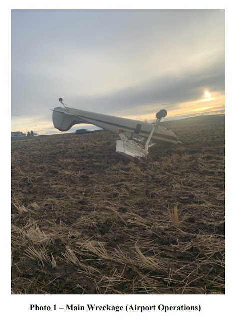
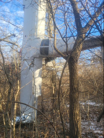
The pilot increased the flaps to 40° and he executed a teardrop-style left turn to the runway. He reported he was below the tree line but was still too high to make a touchdown. The airplane “floated long” and landed on airport property beyond the runway into trees, at stall speed. The airplane came to rest approximately at a 90° angle in the trees, with the left wing pointing down toward the ground and the right wing toward the sky. The three occupants were able to egress from the airplane without further incident.

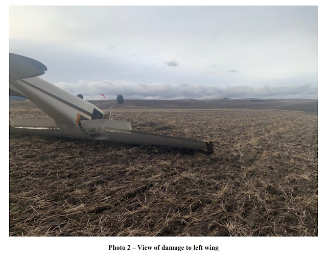
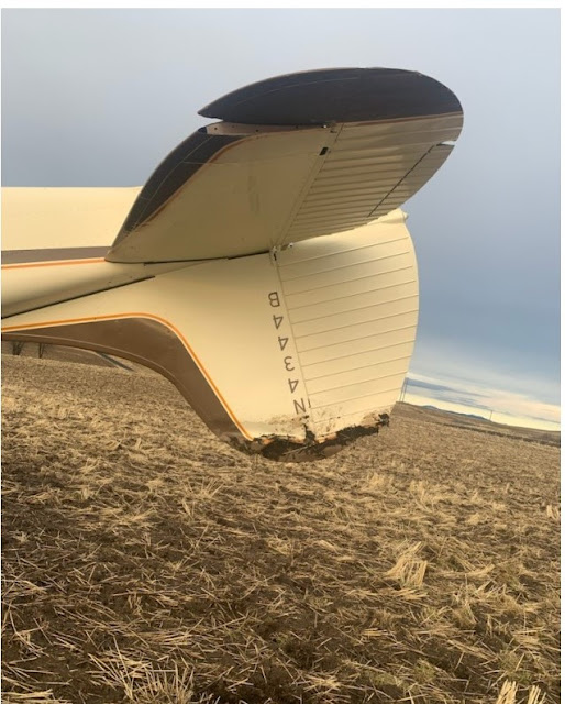
The airplane sustained substantial damage to the left wing and to the fuselage. The airplane was recovered from the accident site for a future examination. The airplane was modified with a Federal Aviation Administration-approved supplemental type certificate to utilize automotive fuel (commonly called “MOGAS”), which the pilot used to fuel the airplane with before the accident flight. 

Aircraft and Owner/Operator Information

Aircraft Make: Cessna
Registration: N3964L
Model/Series: 172G
Aircraft Category: Airplane
Amateur Built:
Operator: On file
Operating Certificate(s) Held: None
Operator Designator Code: None

Meteorological Information and Flight Plan

Conditions at Accident Site: VMC 
Condition of Light: Day
Observation Facility, Elevation: KYNG,1186 ft msl 
Observation Time: 14:51 Local
Distance from Accident Site: 7 Nautical Miles
Temperature/Dew Point: -1°C /-12°C
Lowest Cloud Condition: Few / 12000 ft AGL
Wind Speed/Gusts, Direction: 10 knots / 19 knots, 160°
Lowest Ceiling: None
Visibility: 10 miles
Altimeter Setting: 30.31 inches Hg 
Type of Flight Plan Filed: None
Departure Point: Youngstown, OH
Destination: Youngstown, OH

Wreckage and Impact Information

Crew Injuries: 1 None 
Aircraft Damage: Substantial
Passenger Injuries: 2 None 
Aircraft Fire: None
Ground Injuries: 
Aircraft Explosion: None
Total Injuries: 3 None 
Latitude, Longitude: 41.136767,-80.617378 (est)


LIBERTY — A pilot averted catastrophe Saturday, crash landing his plane in a wooded area just north of Lansdowne Airport without injuring himself or two family members.

“I’m both happy and sad,” pilot Christopher T. Tornello of Liberty said less than two hours after the crash. “I’m sad about the plane and happy no one got a scratch on them. I’ve never had this happen before.”

Tornello, 65, has had his pilot’s license since 1981, according to his wife, Roberta Tornello, who also is a pilot. She had a headache and decided to visit a friend instead of going on the flight with her daughter, Melissa Fike of Cortland, and her 8-year-old granddaughter, Ida Kay Fike.

Roberta Tornello said her husband was going in for a downwind landing at Lansdowne Airport, 2008 Lansdowne Blvd., about 3:30 p.m. Saturday when the engine of the Cessna 172G began to sputter.

“He was only 500, 600 feet above ground,” she said. “That’s the worst time for the engine to go out. There’s not enough speed or height to get it to the runway.”

The aircraft crashed into a wooded area just north of Homestead Road. From photos provided by Tornello’s wife and those posted by Fike on social media, the plane was suspended in the trees and had visible exterior damage.

The Ohio State Highway Patrol in Southington said the accident is under investigation.

The aircraft just had its annual inspection, Roberta Tornello said, and no issues were detected at the time. This was the plane’s second flight since the inspection.

Her daughter took video on her phone of her father landing the plane in the trees and immediately called her mother.

“She said they were OK physically,” Roberta Tornello said. “Mentally might take a little time.”

Christopher Tornello said, “I did what I was trained to do. I thank God it was enough to keep everyone safe. It’s the happiest ending in that way.”


A passenger involved in a plane crash that happened earlier this evening spoke with 21 News to detail the accident.

Melissa Fike was flying as a passenger in her father's 172 Cessna plane when the engine began cutting in and out. 

Fike's 8 year old daughter was also riding in the backseat. 

Fike's father has been a pilot since 1981, and the plane was just recently inspected by a mechanic. 

Fike says her father is an excellent pilot. 

Around 3:36 p.m., Liberty dispatch received a call and arrived to the accident shortly after. 

Ohio State Patrol officers are now handling the crash and Liberty first responders have since left the scene.

Fike, her daughter and her father are all safe. 

 
LIBERTY, Ohio (WKBN) — A plane crashed in Liberty on Saturday, January 8.

The Cessna 172G plane crashed into a tree on Homestead Road. The call came in just after 3:30 p.m.

The caller told dispatchers the plane crashed around 50 yards away from his backyard and he heard people talking.

Liberty police and fire as well as the Ohio State Highway Patrol were on the scene.

OSHP said there were no injuries. Christopher Tornello, 65, was piloting the plane and 43-year-old Melissa Fike and a juvenile were passengers.

The pilot lives in Liberty and was trying to land the plane at Lansdowne Airport when the plane lost power, according to OSHP.

Officials are still trying to determine the cause of the crash. Liberty crews had to use a ladder to get the pilot off the plane.

Liberty Fire Chief Douglas Theobald said the crash was due to an apparent mechanical issue or engine failure.

Fatal accident occurred January 07, 2022 in Grand County, Utah


Grand County Sheriff's Search and Rescue -

A 55 year-old Moab man died in a wingsuit flight from a cliff overlooking Professor Valley near Rocky Rapid on January 7th. The incident was reported shortly after noon when his satellite messaging device detected an impact and automatically transmitted an SOS signal. His companion also activated an inReach device from atop the cliff.

Grand County Sheriff's Search and Rescue responded with a boat and technical rescue gear and met Grand County EMS at the Rocky Rapid boat ramp. Classic Air Medical was dispatched and located the subject about 1,000 feet below his jump point and about 700 feet above the river. Two medics from the helicopter crew were dropped off nearby. They hiked to the subject and confirmed he was deceased.

Due to the hazardous nature of the steep talus slope on which the subject was located, a hoist helicopter from the Utah Department of Public Safety (DPS) was requested and arrived a few hours later. In the interim, the Classic helicopter flew two GCSAR members to the scene to prepare the subject for the hoist operation. The DPS ship then transported the subject and two GCSAR members back to the boat ramp. The incident, GCSAR’s first of the year, was completed just after sunset.

The Grand County Sheriff's Office is a full service agency that includes Patrol, Investigations, Court Security, Dispatch, Emergency Management and Search and Rescue Divisions. We are proud to oversee the public safety for our residents and 2.5 million annual tourists who visit the 3,684 square miles that comprise Grand County, Utah.

GRAND COUNTY, Utah – A man was pronounced dead on January 7 as a result of a wingsuit flight gone awry.

According to the Grand County Sheriff’s Office, the 55 year-old Moab resident died in his flight from a cliff overlooking Professor Valley near Rocky Rapid. The incident was reported midday “when his satellite messaging device detected an impact and automatically transmitted an SOS signal.”

After Grand County Search and Rescue sent out an emergency rescue, a helicopter located the man about 1,000 feet below the cliff where he had jumped from and about 700 feet above the river.

Two medics who were dropped off by the helicopter hiked to the man and confirmed he was deceased.

Grand County Sheriffs indicated that the man was located on a steep talus slope that was treacherous enough to require a “hoist operation.”

Wingsuit flying, which started in the late 1990s, is commonly known as one of the most dangerous extreme sports on the planet.

According to a survey done by Dr. Omer Mei-Dan, a BASE jumper and sports medicine doctor, 72% of wingsuit jumpers had seen firsthand a death or major injury in the sport. 76% reported having at least one near-miss incident where a possible fatality was avoided.

Abnormal Runway Contact: Cessna 170B, N4344B; accident occurred January 08, 2021 at Schoepflin Airport (WN26), Palouse, Whitman County, Washington


Aviation Accident Final Report - National Transportation Safety Board

The National Transportation Safety Board did not travel to the scene of this accident. 

Additional Participating Entity:
Federal Aviation Administration / Flight Standards District Office; Spokane, Washington

Investigation Docket - National Transportation Safety Board:
   

Location: Palouse, Washington
Accident Number: WPR21LA083
Date and Time: January 8, 2021, 14:00 Local
Registration: N4344B
Aircraft: Cessna 170B
Aircraft Damage: Substantial
Defining Event: Abnormal runway contact
Injuries: 1 Minor, 1 None
Flight Conducted Under: Part 91: General aviation - Instructional

Analysis

The flight instructor of the tailwheel equipped airplane reported that, during an instructional flight, the student pilot’s landing flare was not sufficient to preclude a bounce. The student added power, and the airplane turned to the left toward hangars. The flight instructor took over the flight controls and continued the left turn to avoid hangars. The airplane departed the runway surface into a field. The wheels became stuck in the muddy ground and the airplane nosed over and came to rest inverted. The wings and vertical stabilizer were substantially damaged.

Probable Cause and Findings

The National Transportation Safety Board determines the probable cause(s) of this accident to be:
The student pilot’s improper landing flare and loss of directional control and the flight instructor’s delayed remedial action resulted in a runway excursion and nose over. 

Findings

Personnel issues Decision making/judgment - Student/instructed pilot
Personnel issues Aircraft control - Student/instructed pilot
Aircraft Landing flare - Incorrect use/operation
Personnel issues Monitoring other person - Instructor/check pilot
Personnel issues Delayed action - Instructor/check pilot
Environmental issues Wet/muddy terrain - Contributed to outcome

Factual Information

History of Flight

Landing-flare/touchdown Abnormal runway contact (Defining event)
Landing-landing roll Loss of control on ground
Landing-landing roll Nose over/nose down

Flight instructor Information

Certificate: Commercial; Flight instructor
Age: 61,Male
Airplane Rating(s): Single-engine land; Multi-engine land
Seat Occupied: Right
Other Aircraft Rating(s): None 
Restraint Used: Lap only
Instrument Rating(s): Airplane 
Second Pilot Present: Yes
Instructor Rating(s): Airplane multi-engine; Airplane single-engine; Instrument airplane
Toxicology Performed:
Medical Certification: Class 2 Without waivers/limitations
Last FAA Medical Exam: July 1, 2020
Occupational Pilot: No 
Last Flight Review or Equivalent: June 27, 2019
Flight Time: (Estimated) 2174 hours (Total, all aircraft), 11 hours (Total, this make and model), 2046 hours (Pilot In Command, all aircraft), 26 hours (Last 90 days, all aircraft), 9 hours (Last 30 days, all aircraft) 

Student pilot Information

Certificate: Student
Age: 39, Male
Airplane Rating(s): None 
Seat Occupied: Left
Other Aircraft Rating(s): None 
Restraint Used: Lap only
Instrument Rating(s): None 
Second Pilot Present: Yes
Instructor Rating(s): None 
Toxicology Performed:
Medical Certification: Class 3 Without waivers/limitations
Last FAA Medical Exam: December 17, 2019
Occupational Pilot: No 
Last Flight Review or Equivalent:
Flight Time: (Estimated) 69 hours (Total, all aircraft), 8 hours (Total, this make and model), 11 hours (Pilot In Command, all aircraft), 8 hours (Last 90 days, all aircraft), 3 hours (Last 30 days, all aircraft)

Aircraft and Owner/Operator Information

Aircraft Make: Cessna 
Registration: N4344B
Model/Series: 170B NO SERIES 
Aircraft Category: Airplane
Year of Manufacture: 1955
Amateur Built:
Airworthiness Certificate: Normal 
Serial Number: 26688
Landing Gear Type: Tailwheel 
Seats: 4
Date/Type of Last Inspection: September 3, 2020 Annual 
Certified Max Gross Wt.:
Time Since Last Inspection: 17 Hrs
Engines: 1 Reciprocating
Airframe Total Time: 3173.2 Hrs
Engine Manufacturer: CONT MOTOR
ELT: Installed
Engine Model/Series: 0-300 SER
Registered Owner:
Rated Power: 145 Horsepower
Operator: On file 
Operating Certificate(s) Held: None

Meteorological Information and Flight Plan

Conditions at Accident Site: Visual (VMC) 
Condition of Light: Day
Observation Facility, Elevation: KPUW, 2551 ft msl 
Distance from Accident Site: 9 Nautical Miles
Observation Time: 13:53 Local
Direction from Accident Site: 189°
Lowest Cloud Condition: Scattered / 12000 ft AGL
Visibility: 10 miles
Lowest Ceiling: None 
Visibility (RVR):
Wind Speed/Gusts: / 
Turbulence Type Forecast/Actual: None / None
Wind Direction: 
Turbulence Severity Forecast/Actual: N/A / N/A
Altimeter Setting: 30.18 inches Hg 
Temperature/Dew Point: 3°C / 0°C
Precipitation and Obscuration: No Obscuration; No Precipitation
Departure Point: Palouse, WA
Type of Flight Plan Filed: None
Destination: Palouse, WA 
Type of Clearance: None
Departure Time: 
Type of Airspace: Class G

Airport Information

Airport: SCHOEPFLIN WN26 
Runway Surface Type: Asphalt
Airport Elevation: 2607 ft msl 
Runway Surface Condition: Dry
Runway Used: 11 
IFR Approach: None
Runway Length/Width: 1600 ft / 25 ft
VFR Approach/Landing: Full stop; Traffic pattern

Wreckage and Impact Information

Crew Injuries: 1 Minor, 1 None 
Aircraft Damage: Substantial
Passenger Injuries:
Aircraft Fire: None
Ground Injuries: 
Aircraft Explosion: None
Total Injuries: 1 Minor, 1 None 
Latitude, Longitude: 46.884969,-117.07687


Tailstrike: Hughes 500D (369D), N8612F; accident occurred January 09, 2021 in Winthrop, Okanogan County, Washington


Aviation Accident Final Report - National Transportation Safety Board

The National Transportation Safety Board did not travel to the scene of this accident.

Additional Participating Entity: 
Federal Aviation Administration / Flight Standards District Office; Spokane, Washington

Investigation Docket - National Transportation Safety Board:


Location: Winthrop, Washington 
Accident Number: WPR21LA084
Date and Time: January 9, 2021, 12:30 Local 
Registration: N8612F
Aircraft: Hughes 369D
Aircraft Damage: Substantial
Defining Event: Tailstrike 
Injuries: 2 None
Flight Conducted Under: Part 91: General aviation - Positioning

Analysis

The pilot reported that, while landing in a snow-covered, unimproved landing zone, the helicopter drifted rearward, the tail rotor struck a snowbank, and the helicopter began to spin to the right. The pilot reduced the throttle setting to off and applied left pedal to reduce the spin, but the helicopter drifted to the right and the right skid impacted snow. The helicopter subsequently rolled over and impacted terrain. The tailboom and the main and tail rotor drive systems were substantially damaged. The pilot reported that there were no preaccident mechanical failures or malfunctions with the helicopter that would have precluded normal operation.

Probable Cause and Findings

The National Transportation Safety Board determines the probable cause(s) of this accident to be:
The pilot’s failure to adequately monitor the environment which resulted in a collision with a snowbank and subsequent loss of control.

Findings

Personnel issues Monitoring environment - Pilot
Personnel issues Aircraft control - Pilot
Environmental issues Sloped/uneven terrain - Effect on operation

Factual Information

History of Flight

Landing-flare/touchdown Tailstrike (Defining event)

Pilot Information

Certificate: Commercial  
Age: 60, Male
Airplane Rating(s): Single-engine land; Multi-engine land
Seat Occupied: Left
Other Aircraft Rating(s): Glider; Helicopter 
Restraint Used: 4-point
Instrument Rating(s): Airplane 
Second Pilot Present: No
Instructor Rating(s): Helicopter 
Toxicology Performed:
Medical Certification: Class 2 With waivers/limitations 
Last FAA Medical Exam: March 17, 2020
Occupational Pilot: Yes 
Last Flight Review or Equivalent: October 29, 2020
Flight Time: 8125 hours (Total, all aircraft), 575 hours (Total, this make and model), 8025 hours (Pilot In Command, all aircraft), 46 hours (Last 90 days, all aircraft), 21 hours (Last 30 days, all aircraft), 1 hours (Last 24 hours, all aircraft)

Passenger Information

Certificate: 
Age: Male
Airplane Rating(s): 
Seat Occupied: Right
Other Aircraft Rating(s):
Restraint Used: 4-point
Instrument Rating(s):
Second Pilot Present: No
Instructor Rating(s):
Toxicology Performed:
Medical Certification:
Last FAA Medical Exam:
Occupational Pilot: 
Last Flight Review or Equivalent:
Flight Time:

Aircraft and Owner/Operator Information

Aircraft Make: Hughes 
Registration: N8612F
Model/Series: 369D 
Aircraft Category: Helicopter
Year of Manufacture: 1977
Amateur Built:
Airworthiness Certificate: Normal
Serial Number: 570142D
Landing Gear Type: None; High skid
Seats: 4
Date/Type of Last Inspection: January 8, 2021 100 hour 
Certified Max Gross Wt.: 3000 lbs 
Time Since Last Inspection: 1.9 Hrs 
Engines: 1 Turbo shaft
Airframe Total Time: 21451.2 Hrs as of last inspection
Engine Manufacturer: ALLISON
ELT: C126 installed, not activated 
Engine Model/Series: 250-C20R
Registered Owner: 
Rated Power: 250 Horsepower
Operator: On file
Operating Certificate(s) Held: Rotorcraft external load (133), Commuter air carrier (135), Agricultural aircraft (137)

Meteorological Information and Flight Plan

Conditions at Accident Site: Visual (VMC)
Condition of Light: Day
Observation Facility, Elevation: S52 
Distance from Accident Site: 3.1 Nautical Miles
Observation Time: 10:00 Local 
Direction from Accident Site: 150°
Lowest Cloud Condition: Unknown / 3000 ft AGL
Visibility: 10 miles
Lowest Ceiling: Overcast / 3000 ft AGL
Visibility (RVR):
Wind Speed/Gusts: / 
Turbulence Type Forecast/Actual: None / None
Wind Direction: 
Turbulence Severity Forecast/Actual: N/A / N/A
Altimeter Setting: 30.32 inches Hg 
Temperature/Dew Point: 2.2°C / -6.7°C
Precipitation and Obscuration:
Departure Point: Darrington, WA (1S2)
Type of Flight Plan Filed: VFR
Destination: Winthrop, WA
Type of Clearance: None
Departure Time: 11:15 Local
Type of Airspace: Class G

Airport Information

Airport: Methow Valley State S52
Runway Surface Type:
Airport Elevation: 1706 ft msl 
Runway Surface Condition: Snow
Runway Used:
IFR Approach: None
Runway Length/Width:
VFR Approach/Landing: Full stop; Straight-in

Wreckage and Impact Information

Crew Injuries: 1 None 
Aircraft Damage: Substantial
Passenger Injuries: 1 None 
Aircraft Fire: None
Ground Injuries: 
Aircraft Explosion: None
Total Injuries: 2 None 
Latitude, Longitude: 48.47318,-120.1782(est)

Preventing Similar Accidents

Manage Risk: Good Decision-making and Risk Management Practices are Critical

Although few pilots knowingly accept severe risks, accidents can also result when several risks of marginal severity are not identified or are ineffectively managed by the pilot and compound into a dangerous situation. Accidents also result when the pilot does not accurately perceive situations that involve high levels of risk. Ineffective risk management or poor aeronautical decision-making can be associated with almost any type of fatal general aviation accident.

By identifying personal attitudes that are hazardous to safe flying, applying behavior modification techniques, recognizing and coping with stress, and effectively using all resources, pilots can substantially improve the safety of each flight. Remember that effective risk management takes practice. It is a decision-making process by which pilots can systematically identify hazards, assess the degree of risk, and determine the best course of action. Pilots should plan ahead with flight diversion or cancellation alternatives and not be afraid to change their plans; it can sometimes be the difference between arriving safely late or not arriving at all.

See http://www.ntsb.gov/safety/safety-alerts/documents/SA_023.pdf for additional resources.

The NTSB presents this information to prevent recurrence of similar accidents. Note that this should not be considered guidance from the regulator, nor does this supersede existing FAA Regulations (FARs). 

Aerodynamic Stall/Spin: Air Tractor AT-502, N4540C; accident occurred January 09, 2021 in Cushing, Payne County, Oklahoma


Aviation Accident Final Report - National Transportation Safety Board
 
 
The National Transportation Safety Board did not travel to the scene of this accident.

Additional Participating Entity: 
Federal Aviation Administration / Flight Standards District Office; Oklahoma City, Oklahoma

Investigation Docket - National Transportation Safety Board:

Location: Cushing, Oklahoma 
Accident Number: CEN21LA110
Date and Time: January 9, 2021, 14:50 Local
Registration: N4540C
Aircraft: AIR TRACTOR INC AT-502
Aircraft Damage: Substantial
Defining Event: Aerodynamic stall/spin
Injuries: 1 None
Flight Conducted Under: Part 137: Agricultural

Analysis

The pilot stated that he intended to depart from a soft, muddy runway and was having a difficult time becoming airborne. When the airplane reached a spot of the runway that was not as muddy, the airplane “popped out of the mud” and reached an altitude of about 30 ft above the ground. Before he could lower the nose to gain airspeed, the left wing stalled and the airplane impacted the surrounding terrain resulting in substantial damage to the fuselage, tail, and both wings. The pilot stated that there were no mechanical anomalies with the airplane that would have precluded normal operations.

Probable Cause and Findings

The National Transportation Safety Board determines the probable cause(s) of this accident to be:
The pilot’s decision to takeoff from unsuitable terrain which resulted in an aerodynamic stall and subsequent impact with terrain.

Findings

Personnel issues Decision making/judgment - Pilot
Environmental issues Soft surface - Decision related to condition
Personnel issues Aircraft control - Pilot
Aircraft Airspeed - Not attained/maintained

Factual Information

History of Flight

Takeoff Aerodynamic stall/spin (Defining event)

Pilot Information

Certificate: Commercial
Age: 35, Male
Airplane Rating(s): Single-engine land; Multi-engine land
Seat Occupied: Single
Other Aircraft Rating(s): None 
Restraint Used: 4-point
Instrument Rating(s): Airplane
Second Pilot Present: No
Instructor Rating(s): None
Toxicology Performed:
Medical Certification: Class 2 Without waivers/limitations
Last FAA Medical Exam: March 5, 2020
Occupational Pilot: UNK
Last Flight Review or Equivalent: September 6, 2020
Flight Time: 1198.8 hours (Total, all aircraft), 666.2 hours (Total, this make and model), 1145.8 hours (Pilot In Command, all aircraft), 15 hours (Last 90 days, all aircraft), 5 hours (Last 30 days, all aircraft)

Aircraft and Owner/Operator Information

Aircraft Make: AIR TRACTOR INC
Registration: N4540C
Model/Series: AT-502
Aircraft Category: Airplane
Year of Manufacture: 1991
Amateur Built:
Airworthiness Certificate: Normal; Restricted (Special) 
Serial Number: 502-0119
Landing Gear Type: Tailwheel 
Seats: 1
Date/Type of Last Inspection: Unknown 
Certified Max Gross Wt.:
Time Since Last Inspection: 
Engines: 1
Airframe Total Time:
Engine Manufacturer:
ELT: 
Engine Model/Series:
Registered Owner: 
Rated Power:
Operator: 
Operating Certificate(s) Held: Agricultural aircraft (137)

Meteorological Information and Flight Plan

Conditions at Accident Site: Visual (VMC) 
Condition of Light: Day
Observation Facility, Elevation: KCUH, 916 ft msl 
Distance from Accident Site: 2 Nautical Miles
Observation Time: 15:15 Local
Direction from Accident Site: 74°
Lowest Cloud Condition:
Visibility: 10 miles
Lowest Ceiling: 
Visibility (RVR):
Wind Speed/Gusts: 3 knots / 
Turbulence Type Forecast/Actual:  /
Wind Direction: 30°
Turbulence Severity Forecast/Actual:  /
Altimeter Setting: 30.33 inches Hg 
Temperature/Dew Point: 6°C / -2°C
Precipitation and Obscuration: No Obscuration; No Precipitation
Departure Point: Cushing, OK
Type of Flight Plan Filed: None
Destination: Cushing, OK
Type of Clearance: None
Departure Time: 
Type of Airspace: Class G

Airport Information

Airport: Private PVT
Runway Surface Type:
Airport Elevation: 0 ft msl 
Runway Surface Condition: Rough; Soft; Standing water
Runway Used: 
IFR Approach: None
Runway Length/Width:
VFR Approach/Landing: None

Wreckage and Impact Information

Crew Injuries: 1 None
Aircraft Damage: Substantial
Passenger Injuries: N/A 
Aircraft Fire: None
Ground Injuries: 
Aircraft Explosion: None
Total Injuries: 1 None
Latitude, Longitude: 35.939235,-96.820585

Fuel Starvation: Cessna T210L Turbo Centurion, N94227; accident occurred January 01, 2020 near Ada Regional Airport (KADH), Pontotoc County, Oklahoma


Aviation Accident Final Report - National Transportation Safety Board 

The National Transportation Safety Board did not travel to the scene of this accident. 

Additional Participating Entities: 
Federal Aviation Administration / Flight Standards District Office; Oklahoma City, Oklahoma 
Continental Motors; Mobile, Alabama
Textron Aviation; Wichita, Kansas

Investigation Docket - National Transportation Safety Board:


Location: Ada, Oklahoma
Accident Number: CEN20LA053
Date and Time: January 1, 2020, 15:46 Local 
Registration: N94227
Aircraft: Cessna T210 
Aircraft Damage: Substantial
Defining Event: Fuel starvation
Injuries: 2 Minor
Flight Conducted Under: Part 91: General aviation - Personal

Analysis

The pilot and one passenger were conducting a cross-country flight in the single engine airplane. The pilot thought that the fuel tanks had been topped off on a level surface before departure, but he did not observe the fueling and did not confirm the actual fuel quantity before departure. About 3.5 hours after departure, after having switched from the left fuel tank to the right, the pilot reported that the engine experienced a loss of power and told air traffic control (ATC) that he had a fuel issue and needed to land immediately. The pilot was able to restart the engine briefly but again experienced a loss of engine power. He made a forced landing to a field then continued into a fence and impacted several trees and the airplane sustained substantial damage to both wings, fuselage, empennage, and engine mounts.

Postaccident examination of the wreckage revealed that both fuel tanks were breached at the leading edges. The fuel tank caps were secured in place and there was no sign of blue fuel staining on the wings. The examination did not reveal any mechanical malfunctions or anomalies that would have precluded normal operation.

A postaccident fuel calculation based on fuel receipts for the round-trip cross-country flight revealed that the airplane would have contained about 69 gallons of fuel before departure. Based on the fuel calculation, there should have been about 26 gallons of fuel remaining in the fuel tanks during the loss of engine power. The pilot stated that he did not complete a preflight fuel burn calculation or check the amount of fuel on the fuel receipt after fueling.

It is likely that the pilot did not switch to the right fuel tank when he reported doing so or did not allow enough time for the fuel to reach the engine before attempting an engine restart. Based on postaccident fuel calculations and the lack of evidence of a fuel tank leak, the pilot did not adequately manage the available fuel during the flight, which resulted in fuel starvation and a loss of engine power.

The National Transportation Safety Board determines the probable cause(s) of this accident to be:
The pilot’s inadequate fuel management, which resulted in a total loss of engine power due to fuel starvation, and the pilot’s inadequate preflight inspection and preflight fuel planning.

Findings

Personnel issues Preflight inspection - Pilot
Personnel issues Fuel planning - Pilot
Personnel issues Decision making/judgment - Pilot
Aircraft Fuel - Fluid management
Environmental issues Rough terrain - Contributed to outcome

Factual Information

History of Flight

Prior to flight Aircraft inspection event
Enroute-cruise Fuel starvation (Defining event)
Landing-flare/touchdown Off-field or emergency landing

On January 1, 2020, about 1546 central standard time, a Cessna T210L airplane, N94227, was substantially damaged with it was involved in an accident near Ada, Oklahoma. The pilot and one passenger sustained minor injuries. The airplane was operated as a Title 14 Code of Federal Regulations Part 91 personal flight.

The pilot reported that he had the fuel tanks topped off at Centennial Airport (APA), Denver, Colorado, and departed with 90 gallons of fuel. He had the right fuel tank selected during takeoff and initial climb and noted a fuel burn of 16.5 gallons per hour during the climb. After climbing to 11,500 ft mean sea level, he noted a fuel burn of 14.5 gallons per hour and switched to the left tank. After using the left tank for 1.75 hours, he switched to the right tank for about 1.25 hours.

According to an ATC summary and automatic dependent surveillance-broadcast data, at 1539, the airplane was in cruise flight about 11,500 ft mean sea level when the pilot reported a fuel issue to ATC and requested to land immediately. About 1 minute later, while receiving directions to Ada Regional Airport (ADH), Ada, Oklahoma, the pilot stated that he restarted the engine and continued to descend toward ADH. According to the pilot, when the engine experienced a loss of power, he selected the left fuel tank and the engine successfully restarted for a short time. The engine again experienced a loss of power, and he was unable to restart it, so he proceeded to ADH. The controller mistakenly reported the ADH airport identifier as ADA several times when queried by the pilot.

At 1543, the pilot stated that he was having issues with his instruments and then received a nogyro vector approach from ATC. At 1545, the pilot stated that he had the airport in sight. According to the pilot, as he descended and approached ADH, he extended the landing gear and flaps. At 1546, radar contact was lost, and the pilot stated, “I’m not sure I can make this runway, I’m trying.” There were no further transmissions from the pilot. The airplane cleared one set of powerlines then the pilot maneuvered under a second set of powerlines and made a forced landing.

Pilot Information

Certificate: Private 
Age: 61, Male
Airplane Rating(s): Single-engine sea 
Seat Occupied: Left
Other Aircraft Rating(s): None
Restraint Used: 3-point
Instrument Rating(s): None
Second Pilot Present: No
Instructor Rating(s): None 
Toxicology Performed: No
Medical Certification: Class 3 With waivers/limitations 
Last FAA Medical Exam: July 20, 2018
Occupational Pilot: No
Last Flight Review or Equivalent: October 19, 2019
Flight Time: 1915 hours (Total, all aircraft), 1582 hours (Pilot In Command, all aircraft), 8.3 hours (Last 90 days, all aircraft), 6 hours (Last 30 days, all aircraft)

Passenger Information

Certificate:
Age: Female
Airplane Rating(s): 
Seat Occupied: Right
Other Aircraft Rating(s):
Restraint Used: 3-point
Instrument Rating(s): 
Second Pilot Present: No
Instructor Rating(s): 
Toxicology Performed: No
Medical Certification:
Last FAA Medical Exam:
Occupational Pilot: No 
Last Flight Review or Equivalent:
Flight Time:

The pilot completed a 1.4-hour flight review in the accident airplane on October 24, 2019, then flew the airplane 1 hour back home. Before these flights, the last time he had flown the airplane was on February 13, 2016. 

Aircraft and Owner/Operator Information

Aircraft Make: Cessna
Registration: N94227
Model/Series: T210 L 
Aircraft Category: Airplane
Year of Manufacture: 1974
Amateur Built:
Airworthiness Certificate: Normal 
Serial Number: 21060549
Landing Gear Type: Retractable - Tricycle
Seats: 6
Date/Type of Last Inspection: October 6, 2019 Annual 
Certified Max Gross Wt.: 3800 lbs
Time Since Last Inspection: 12 Hrs
Engines: 1 Reciprocating
Airframe Total Time: 5997 Hrs as of last inspection
Engine Manufacturer: Continental Motors
ELT: Installed, not activated 
Engine Model/Series: TSIO-520-R
Registered Owner: 
Rated Power: 310 Horsepower
Operator: On file 
Operating Certificate(s) Held: None

The airplane's pilot operating handbook listed that the airplane holds 90 gallons of fuel, 1 gallon of which is unusable (45 gallons in each tank, 0.5 gallon of which is unusable).

Meteorological Information and Flight Plan

Conditions at Accident Site: Visual (VMC)
Condition of Light: Day
Observation Facility, Elevation: KADH, 1016 ft msl 
Distance from Accident Site: 1 Nautical Miles
Observation Time: 21:55 Local
Direction from Accident Site: 15°
Lowest Cloud Condition: Clear
Visibility 10 miles
Lowest Ceiling: None 
Visibility (RVR):
Wind Speed/Gusts: 17 knots / 26 knots
Turbulence Type Forecast/Actual:  /
Wind Direction: 200° 
Turbulence Severity Forecast/Actual:  /
Altimeter Setting: 29.68 inches Hg
Temperature/Dew Point: 11°C / 1°C
Precipitation and Obscuration: No Obscuration; No Precipitation
Departure Point: Denver, CO (APA)
Type of Flight Plan Filed: None
Destination: Shreveport, LA (SHV) 
Type of Clearance: VFR flight following
Departure Time: 12:06 Local 
Type of Airspace: Class E
Page 6 of 9 CEN20LA053

Airport Information

Airport: Ada Regional Airport ADH 
Runway Surface Type:
Airport Elevation: 1015 ft msl 
Runway Surface Condition: Unknown
Runway Used: 
IFR Approach: None
Runway Length/Width:
VFR Approach/Landing: Forced landing

Wreckage and Impact Information

Crew Injuries: 1 Minor
Aircraft Damage: Substantial
Passenger Injuries: 1 Minor 
Aircraft Fire: None
Ground Injuries: 
Aircraft Explosion: None
Total Injuries: 2 Minor
Latitude, Longitude: 34.807333,-96.66704(est)

Pictures of the accident site showed that the airplane had landed in a field, continued through a fence and impacted a line of trees. The airplane came to rest upright with the nose tilted up and the right wing low (figure 1). Postaccident examination revealed that the fuel tanks were both breached at the leading edges. The fuel tank caps were secured in place and there was no sign of blue fuel staining on the wings. The inspector did not observe any fuel in the right fuel tank, although the wing was on a decline. The fuel selector had been turned off after the accident.

Postaccident examination of the airframe and engine examine revealed no preaccident anomalies that would have precluded normal operation.

Additional Information

A review of the historical ADS-B data from FlightAware.com showed that, on December 24, 2019, the pilot had completed a multi-leg cross-country flight from Lakefront Airport (NEW), New Orleans, Louisiana, to Cox Field Airport (PRX), Paris, Texas, for a total of 2.5 hours enroute. He then flew to Liberal Mid-America Regional Airport (LBL), Liberal, Kansas, for 2.0 hours en route, and finally to APA for 1.75 hours en route. Fuel receipts showed that he added 52.8 gallons of fuel at LBL and 46 gallons of fuel at APA. However, the investigation could not determine the amount of fuel added to each tank nor the total amount of fuel in each tank after the fueling. 

The pilot stated that the airplane was on level ground when it was fueled at APA. When asked if he observed the fueling process he stated, “I was not on the ladder with [the airport employee who fueled the airplane] … he claimed he topped it off I had no reason to doubt him.” The pilot stated that he did not complete a preflight fuel burn calculation for any of the flights. He did not check the amount of fuel on the fuel receipt or compare it to any fuel calculations because he would have only done so while completing a fuel plan.

The pilot did not open the fuel caps between fueling and the accident flight to confirm the amount of fuel in each tank, but he did confirm that the fuel caps were tight. He did not trust or rely on the fuel gauges in the airplane because they were always “bouncing around” and never showed the right amount. He discussed one time in the recent past when he had topped off the fuel tanks and one of the gauges showed empty.

A postaccident fuel calculation based on the fuel receipts for the round-trip cross-country flight revealed that the airplane would have contained about 69 gallons of fuel before departure from APA. If the airplane departed on the accident flight with 69 gallons, the amount in each tank would have been about 34 gallons. The fuel burn calculation for the accident flight revealed that the airplane likely burned 43 gallons of fuel before the loss of engine power. The fuel calculation revealed that there should have been about 26 gallons of fuel remaining during the loss of engine power. 

Fuel Related: Cessna 150M, N45069; accident occurred January 03, 2020 near Twentynine Palms Airport (KTNP), San Bernardino County, California


Aviation Accident Final Report - National Transportation Safety Board 

The National Transportation Safety Board did not travel to the scene of this accident. 

Additional Participating Entity:
Federal Aviation Administration / Flight Standards District Office; Riverside, California

Investigation Docket - National Transportation Safety Board:


Location: Twentynine Palms, California
Accident Number: WPR20CA060
Date and Time: January 3, 2020, 20:00 Local
Registration: N45069
Aircraft: Cessna 150
Aircraft Damage: Substantial
Defining Event: Fuel related
Injuries: 1 None
Flight Conducted Under: Part 91: General aviation - Personal

Analysis

The pilot reported that, upon arrival at the airport after dark, he attempted to activate the pilot-controlled lights by keying the mike seven times. Shortly later, he repeated the process twice, but the runway lights did not turn on. He circled the area to try to locate the airport but was unsuccessful. The airplane was now low on fuel, so the pilot began looking for a place to make a precautionary landing. He landed the airplane on a dirt road, and during the landing rollout, the nose landing gear separated, and the left wing was substantially damaged. The pilot reported that there were no preaccident mechanical malfunctions or failures with the airplane that would have precluded normal operation.

The Federal Aviation Administration Airport Facility Directory noted that medium-intensity runway lights were available at the airport. To activate the pilot-controlled lighting, the pilot must key the mike five times in 5 seconds. The pilot reported that he did not check what the proper procedures were for operating the pilot-controlled lighting for the runway. Airport personnel checked the pilot-controlled lighting system the day after the accident and reported that there were no malfunctions with the system.

Probable Cause and Findings

The National Transportation Safety Board determines the probable cause(s) of this accident to be:
The pilot's poor preflight planning, during which he failed to verify the proper procedure to activate the runway lights; his inability to locate the airport without lighting; and the airplane's subsequent low-fuel state as he circled looking for the airport, which necessitated a precautionary off-airport landing, during which the nose landing gear separated.

Findings

Personnel issues Flight planning/navigation - Pilot
Environmental issues Dark - Effect on personnel
Aircraft Fuel - Fluid level
Personnel issues Use of policy/procedure - Pilot

Factual Information

History of Flight

Landing Fuel related (Defining event)
Landing Off-field or emergency landing
Landing-landing roll Part(s) separation from AC

Pilot Information

Certificate: Private 
Age: 24, Male
Airplane Rating(s): Single-engine land
Seat Occupied: Left
Other Aircraft Rating(s): None 
Restraint Used:
Instrument Rating(s): Airplane
Second Pilot Present: No
Instructor Rating(s): None 
Toxicology Performed: No
Medical Certification: Class 1 Without waivers/limitations
Last FAA Medical Exam: April 1, 2019
Occupational Pilot: No 
Last Flight Review or Equivalent: January 12, 2018
Flight Time: 260 hours (Total, all aircraft), 28.8 hours (Total, this make and model)

Aircraft and Owner/Operator Information

Aircraft Make: Cessna
Registration: N45069
Model/Series: 150 M
Aircraft Category: Airplane
Year of Manufacture: 1975 
Amateur Built:
Airworthiness Certificate: Normal; Utility 
Serial Number: 15076722
Landing Gear Type: Tricycle
Seats:
Date/Type of Last Inspection: November 18, 2019 Annual 
Certified Max Gross Wt.: 1601 lbs
Time Since Last Inspection: 
Engines: 1 Reciprocating
Airframe Total Time: 6295.3 Hrs as of last inspection
Engine Manufacturer: Continental
ELT: Installed 
Engine Model/Series: O-220-A
Registered Owner: 
Rated Power: 100 Horsepower
Operator: On file 
Operating Certificate(s) Held: None

Meteorological Information and Flight Plan

Conditions at Accident Site: Visual (VMC)
Condition of Light: Night
Observation Facility, Elevation: KNXP, 2051 ft msl 
Distance from Accident Site: 15 Nautical Miles
Observation Time: 18:56 Local 
Direction from Accident Site: 312°
Lowest Cloud Condition: Clear
Visibility: 10 miles
Lowest Ceiling: None
Visibility (RVR):
Wind Speed/Gusts: / 
Turbulence Type Forecast/Actual:  /
Wind Direction: 
Turbulence Severity Forecast/Actual:  /
Altimeter Setting: 30.37 inches Hg
Temperature/Dew Point: 16°C / 0°C
Precipitation and Obscuration: No Obscuration; No Precipitation
Departure Point: Maricopa, AZ (A39)
Type of Flight Plan Filed: None
Destination: Twentynine Palms, CA (TNP)
Type of Clearance: None
Departure Time: 19:00 Local 
Type of Airspace: Class G

Airport Information

Airport: Twentynine Palms TNP 
Runway Surface Type:
Airport Elevation: 1888 ft msl 
Runway Surface Condition: Dry
Runway Used: 
IFR Approach: None
Runway Length/Width:
VFR Approach/Landing: Straight-in

Wreckage and Impact Information

Crew Injuries: 1 None
Aircraft Damage: Substantial
Passenger Injuries:
Aircraft Fire: None
Ground Injuries: N/A 
Aircraft Explosion: None
Total Injuries: 1 None 
Latitude, Longitude: 34.136112,-115.944442

William “Bill” Jensen: Fatal accident occurred December 02, 2021 and Accident occurred August 04, 2020

Sport Copter Vortex, N425RD: Fatal accident occurred December 02, 2021 near Lampson Field Airport (1O2), Lakeport, Lake County, California

This is preliminary information, subject to change, and may contain errors. Any errors in this report will be corrected when the final report has been completed.

The National Transportation Safety Board traveled to the scene of this accident. 

Additional Participating Entity: 
Federal Aviation Administration / Flight Standards District Office; Sacramento, California 


Location: Lakeport, California
Accident Number: WPR22FA053
Date and Time: December 2, 2021, 11:15 Local
Registration: N425RD
Aircraft: RUSSELL W DYER VORTEX 
Injuries: 1 Fatal
Flight Conducted Under: Part 91: General aviation - Personal

On December 2, 2021, about 1115 Pacific daylight time, an experimental amateur-built, Vortex gyrocopter, N425RD, was substantially damaged when it was involved in an accident near Lakeport, California. The pilot was fatally injured. The gyrocopter was operated as a Title 14 Code of Federal Regulations Part 91 personal flight. 

Two witnesses, located about 2 miles west of the accident site, observed the gyrocopter in level flight, and then saw it tumble tail over nose, three times before they lost sight of it behind a tree line.

The gyrocopter came to rest on its left side on flat open terrain covered with brush. Except for a propeller blade tip that had separated and was not located during a search of the area; the wreckage was confined to the accident site.

Flight control continuity was established from the cockpit to the tail section. The engine crankshaft was rotated by hand with no restrictions using the propeller blades. The main rotor blades were rotated with no binding. The fuel tank was breached; however, the smell of fuel was present at the accident site.

The gyrocopter was recovered for further examination.

Aircraft and Owner/Operator Information

Aircraft Make: RUSSELL W DYER 
Registration: N425RD
Model/Series: VORTEX
Aircraft Category: Helicopter
Amateur Built:
Operator: On file
Operating Certificate(s) Held: None
Operator Designator Code:

Meteorological Information and Flight Plan

Conditions at Accident Site: VMC 
Condition of Light: Day
Observation Facility, Elevation: KUKI, 601 ft msl
Observation Time: 10:56 Local
Distance from Accident Site: 15 Nautical Miles
Temperature/Dew Point: 14°C /5°C
Lowest Cloud Condition: Clear 
Wind Speed/Gusts, Direction: / ,
Lowest Ceiling: None 
Visibility: 10 miles
Altimeter Setting: 30.14 inches Hg
Type of Flight Plan Filed:
Departure Point: Lakeport, CA 
Destination:

Wreckage and Impact Information

Crew Injuries: 1 Fatal 
Aircraft Damage: Substantial
Passenger Injuries:
Aircraft Fire: None
Ground Injuries: 
Aircraft Explosion: None
Total Injuries: 1 Fatal
Latitude, Longitude: 39.027041,-122.90724 (est)

Those who may have information that might be relevant to the National Transportation Safety Board (NTSB) investigation may contact them by email witness@ntsb.gov, and any friends and family who want to contact investigators about the accident should email assistance@ntsb.gov. You can also call the NTSB Response Operations Center at 844-373-9922 or 202-314-6290.

Low Altitude Operation/Event:  Cavalon, N635BC; accident occurred August 04, 2020 in Upper Lake, Lake County, California


Aviation Accident Final Report - National Transportation Safety Board 

Additional Participating Entity: 
Federal Aviation Administration / Flight Standards District Office; Sacramento, California

Investigation Docket - National Transportation Safety Board:


Location: Upper Lake, California 
Accident Number: WPR20CA253
Date and Time: August 4, 2020, 09:30 Local 
Registration: N635BC
Aircraft: Robert D Carr Jr Cavalon 
Aircraft Damage: Substantial
Defining Event: Low altitude operation/event 
Injuries: 2 Serious
Flight Conducted Under: Part 91: General aviation - Personal

Analysis

The pilot of the gyroplane reported that, while maneuvering at low altitude over a friend’s property, he looked down and backwards to the ground and inadvertently pulled back on the control stick, slowing the gyroplane to about 20 mph. He attempted to correct by applying full engine power and descending to reestablish airspeed. Concerned the gyroplane would impact trees, he flared just above a wooded area. The gyroplane fell through the trees to the ground substantially damaging the tail section.

The pilot reported that there were no preaccident mechanical failures or malfunctions with the gyroplane that would have precluded normal operation.

Probable Cause and Findings

The National Transportation Safety Board determines the probable cause(s) of this accident to be:
The pilot’s distraction and failure to maintain adequate airspeed during a low altitude maneuver, which resulted in a loss of aircraft control and collision with terrain.

Findings

Personnel issues Task monitoring/vigilance - Pilot
Personnel issues Aircraft control - Pilot
Aircraft Airspeed - Not attained/maintained

Factual Information

History of Flight

Maneuvering-low-alt flying Low altitude operation/event (Defining event)
Emergency descent Collision with terr/obj (non-CFIT)

Pilot Information

Certificate: Sport Pilot
Age: 67, Male
Airplane Rating(s): Single-engine land 
Seat Occupied: Right
Other Aircraft Rating(s): Gyroplane
Restraint Used: 4-point
Instrument Rating(s): None 
Second Pilot Present: No
Instructor Rating(s): None 
Toxicology Performed: No
Medical Certification: None None 
Last FAA Medical Exam:
Occupational Pilot: No 
Last Flight Review or Equivalent:
Flight Time: (Estimated) 853.8 hours (Total, all aircraft), 71.8 hours (Total, this make and model), 803.3 hours (Pilot In Command, all aircraft), 71.3 hours (Last 90 days, all aircraft), 24.8 hours (Last 30 days, all aircraft), 1 hours (Last 24 hours, all aircraft)

Passenger Information

Certificate:
Age: Male
Airplane Rating(s): 
Seat Occupied: Left
Other Aircraft Rating(s): 
Restraint Used: 4-point
Instrument Rating(s): Second
Pilot Present: No
Instructor Rating(s): 
Toxicology Performed:
Medical Certification:
Last FAA Medical Exam:
Occupational Pilot: No 
Last Flight Review or Equivalent:
Flight Time:

Aircraft and Owner/Operator Information

Aircraft Make: Robert D Carr Jr 
Registration: N635BC
Model/Series: Cavalon
Aircraft Category: Gyroplane
Year of Manufacture: 2017
Amateur Built: Yes
Airworthiness Certificate: Experimental light sport (Special)
Serial Number: VO0320
Landing Gear Type: 
Tricycle Seats: 2
Date/Type of Last Inspection: January 15, 2020 Annual 
Certified Max Gross Wt.: 1234 lbs
Time Since Last Inspection: 
Engines: 1 Reciprocating
Airframe Total Time: 272 Hrs 
Engine Manufacturer: Rotax
ELT: C126 installed 
Engine Model/Series: 914 UL
Registered Owner:
Rated Power: 115 Horsepower
Operator: On file
Operating Certificate(s) Held: None

Meteorological Information and Flight Plan

Conditions at Accident Site: Visual (VMC) 
Condition of Light: Day
Observation Facility, Elevation: KUKI, 617 ft msl
Distance from Accident Site: 74 Nautical Miles
Observation Time: 
Direction from Accident Site: 265°
Lowest Cloud Condition: Clear 
Visibility 50 miles
Lowest Ceiling: 
Visibility (RVR):
Wind Speed/Gusts: / 
Turbulence Type Forecast/Actual: None / Terrain-Induced
Wind Direction: 
Turbulence Severity Forecast/Actual:  / Light
Altimeter Setting: 29.99 inches Hg
Temperature/Dew Point: 22°C / 12°C
Precipitation and Obscuration:
Departure Point: Lakeport, CA (1O2) 
Type of Flight Plan Filed: None
Destination: Upper Lake, CA 
Type of Clearance: None
Departure Time: 08:30 Local
Type of Airspace: Class G

Wreckage and Impact Information

Crew Injuries: 1 Serious 
Aircraft Damage: Substantial
Passenger Injuries: 1 Serious 
Aircraft Fire: None
Ground Injuries:
Aircraft Explosion: None
Total Injuries: 2 Serious
Latitude, Longitude: 39.163612,-122.88277

Preventing Similar Accidents

Manage Risk: Good Decision-making and Risk Management Practices are Critical

Although few pilots knowingly accept severe risks, accidents can also result when several risks of marginal severity are not identified or are ineffectively managed by the pilot and compound into a dangerous situation. Accidents also result when the pilot does not accurately perceive situations that involve high levels of risk. Ineffective risk management or poor aeronautical decision-making can be associated with almost any type of fatal general aviation accident.

By identifying personal attitudes that are hazardous to safe flying, applying behavior modification techniques, recognizing and coping with stress, and effectively using all resources, pilots can substantially improve the safety of each flight. Remember that effective risk management takes practice. It is a decision-making process by which pilots can systematically identify hazards, assess the degree of risk, and determine the best course of action. Pilots should plan ahead with flight diversion or cancellation alternatives and not be afraid to change their plans; it can sometimes be the difference between arriving safely late or not arriving at all.

See http://www.ntsb.gov/safety/safety-alerts/documents/SA_023.pdf for additional resources.

The NTSB presents this information to prevent recurrence of similar accidents. Note that this should not be considered guidance from the regulator, nor does this supersede existing FAA Regulations (FARs).