Sunday, December 18, 2022

Aspen-Pitkin County Airport (KASE): Aircraft pilot group on a mission to curb crashes

Barry Vaughn, an alternate member of the local Airport Advisory Board, is shown during Thursday's board meeting. Vaughn recently spearheaded the creation of an airport safety task force, which will hold its first meeting on Monday. It consists of 12 pilots. 
~


Safety, safety, safety.

It’s a word that’s repeated often during nearly any discussion involving the Aspen-Pitkin County Airport and plans for its redevelopment, or airport operations in general.

Safety was a primary topic during the 2019-20 ASE Vision process that led to the formation and adoption of the lengthy list of ­Common Ground recommendations for the redevelopment of the airport. Often, various forms of data are used to support the perception — some say the conclusion — that general aviation operations at the airport are less safe than commercial airline activity. Private jet activity, according to airport officials, accounts for around 80% of overall operations at ASE while commercial flight operations make up about 20%.

In recent months, no one has been singing the safety song louder than Barry Vaughn, an alternate member of the Airport Advisory Board. It was a primary point during his interview for a seat at the board’s table in September. And last month, he convinced other members of the board to join the safety dance through the creation of the “Flight Ops Safety Task Force.”

The task force, according to a county news release, will include local pilots with substantial experience operating at ASE. They will develop recommendations to enhance and improve safety, focusing on general aviation and cultivating partnerships with a variety of aviation organizations to explore opportunities that would help improve aviation safety at the local airport.

In a recent interview, Vaughn stressed that the story concerning the push for the task force was not about him, but the 12 pilots who have been named to the group. Their first meeting will be held on Monday.

“This is not about me,” said Vaughn, a pilot and former civil litigator who practiced in California, where he volunteered on boards to assist the Santa Monica airport with various issues. “To be clear: This is not about me beating my chest.”

Airport Director Dan Bartholomew, however, credited Vaughn with jumpstarting the entity on safety. He said while the task force would have been created eventually, Vaughn was responsible for a faster start.

“He has a passion for it,” Bartholomew said. “But I also think he knows some other folks in the valley that also have passion for it, and were eager to do it as well. So I think it was just was the right time, and he was willing to take it on.”

It’s no secret that the Aspen airport has had its fair share of emergencies, crashes and fatalities involving private aircraft over many decades.

Vaughn said he has been conducting research — at this point, it’s neither exhaustive nor complete — showing 124 accidents since 1964 that are in some way connected to the Aspen airport (such as a flight that originated locally or was bound for ASE) or surrounding airspace. Thirty-six of the 124 involved fatalities. He stressed that his research was not official.

“With most of them, I see a lot of incidents where pilots have taken off from here and they came to some kind of grief in the mountains and it doesn’t have anything to do with the conditions at the airport, it had to do with their mountain flying skills or lack of them, or something they ran into once they were more than five miles out from the airport,” Vaughn said.

So far in 2022, the Aspen airport has experienced six minor mishaps with private planes on airport property itself, according to Bartholomew. While in many cases the causes have yet to be fully revealed, either pilot error or some sort of mechanical problem is usually the culprit. Some of the situations involved a plane sliding off the runway, which results in the airport’s closure. Others are more serious, such as when a jet flew in too low on approach and clipped lights and equipment on the runway. There also have been fuel spills that have required extensive cleanup efforts.

But what can the task force do to help improve the safety record of private-aircraft operators and reduce accidents? U­nlike ­commercial airline pilots, fliers of private aircraft are not required to be trained and certified in the handling of the complexities involved in takeoffs and landings in and around Aspen and its mountainous surroundings.

Vaughn and Bartholomew said the task force will work to cultivate partnerships with a variety of aviation organizations to explore opportunities that would help improve aviation safety. The goal is to provide information that will educate private pilots in a way that’s encouraging and not mandatory. At some point, the pilots could receive extra certifications that could bring about professional opportunities or even liability insurance discounts.

Amory Lovins, a renowned physicist and co-founder of the Rocky Mountain Institute, has been critical of the county’s process involving redevelopment plans for the local airport. However, the Old Snowmass resident lauded the creation of the safety task force in an interview on Saturday when he discussed the creation of a new nonprofit that will be concerning itself with local airport issues.

“I was delighted to see that and I’ve actually written my thanks and congratulations for that safety initiative,” Lovins said. “It’s too early to see where it will go. But a group of expert local pilots certainly has a lot of potential to explore safety issues more deeply and broadly than has been done so far.”


Raytheon Hawker 800XP, N99AP: Accident occurred February 21, 2022 at Aspen-Pitkin County Airport (KASE), Colorado
~


Pilots will tell you that flying into and out of Aspen can be dangerous and so does the data.

“Over the last four decades, there have been over 40 accidents — all involving private, non-airline aircraft — that caused substantial damage or the complete loss of the aircraft in the vicinity of Aspen-Pitkin County Airport (ASE). 

Aspen-Pitkin County Airport challenges arise from factors like the airport’s altitude, its surrounding mountains, its sloping runway that requires most aircraft to land to the south, and takeoff to the north, wind currents, etc.”

That observation was made in the Airport Advisory Board’s “common ground recommendations” adopted by the Board of County Commissioners in December 2020. The recommendations were the fruits of nearly two years of work and public feedback missions led by the vision committee, which, in November, unanimously agreed to the formation of what is called a “flight operations safety task force.”

Last week, the Pitkin County commissioners approved the vision committee’s recommendation for a task force, a collection of 12 seasoned pilots with either local connections or local homes, aimed at recommending measures to increase safety and reduce accidents at the Aspen airport. Their emphasis will be on general aviation.

“It’s a real opportunity for the local pilot community to help in airport affairs,” Roaring Fork Valley pilot Barry Vaughan, who chairs the task force, told the county commissioners. “Airport politics are convoluted and complex, and the pilot community, often perhaps at least from one perspective, isn’t heard much. And, this is something that shouldn’t be controversial. It’s something everybody can get behind.”

Vaughan noted the Federal Aviation Administration’s authority when it comes to regulating airspace, pilot conduct, and licensing, for instance.

“What can the local community do?” he asked.

The answer, he said, is having the task force’s pilots — by using their connections and resources in the aviation field — craft measures the airport advisory board would first review before advancing to the Board of County Commissioners for its approval, he said. The task force ideally would present its initial measures and suggestions to the advisory board this spring, he said.

“These pilots … will not be making any commitments on behalf of the county,” Vaughan explained, “but what they’ll be doing is reaching out to our potential partners in the aviation community and discussing amongst themselves ideas that we can come up with that on a voluntary basis, if pilots get involved, can help make our airspace safer.”

The backgrounds of the group’s pilot advisors run the gamut, he told the board.

“We’ve got representatives of different echelons of flights levels. We’ve got it all covered,” he said, ticking off the names of Daniel Baker, founder of the aviation tracker called FlightAware; Bruce Gordon and Gary Kraft of locally-based EcoFlight; retired commercial pilot Capt. Brett Detwiler; engineer and private pilot Peter Hutter; Mayo Aviation pilot William Landis; developer and private pilot John McBride; investment adviser and pilot Walter Obermeyer; airline transport pilot Mike Solondz; engineer and private pilot Steve Vance; and Tyson Weihs, who is a commercial pilot and founder of ForeFlight, an app for pilots.

“I think it’s good mix of people,” said Commissioner Patti Clapper, adding that, during her career at Aspen Valley Hospital, “I spent too much time dealing with first-hand and meeting with families of victims of incidents at the airport and actually more surrounding our airport. I think this is a great opportunity for us to really look at safety.”

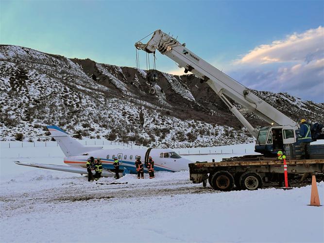
This year alone has seen four runway incidents involving private aircraft at Sardy Field that temporarily closed the airport. There were no fatalities or major injuries, but there was property damage. Two of those runway incidents — on Feb. 21 and Aug. 15 — cost county taxpayers $517,546. The airport also is trying to recoup the expenses from the aircraft owners and their insurers.

The February crash involved a Hawker 800XP business jet that overran the runway on the north side of the airport, rupturing the aircraft’s fuel tanks that spilled some 1,200 gallons of jet fuel on the ground. The aircraft also was totaled.

“A third-party crane and operator was contracted for removal of the aircraft from the runway safety area before the facility could re-open for operations,” according to a supplemental budget request from airport director Dan Bartholomew to the county board. “In addition to the costs incurred for soil remediation and crane services, additional costs were tabulated to account for other resources, including regular and overtime personnel costs for Airport and Public Works staff who responded to the incident.”

The August incident was when a Cessna Citation 560 business jet ran off the runway as it was landing, spilling 220 gallons of jet oil and damaging several airfield lights and signs. Much of the oil was washed away by rain, but “mitigation of the contaminated soil required the services of a third-party contractor,” said Bartholomew’s request. “The majority of the costs to the county resulting from this incident — for which reimbursement from the aircraft owner’s insurance is being sought — is for airfield lights and signage, along with the costs to remediate contaminated soils resulting from this incident.”

The most recent fatal general aviation accident originating from the Aspen airport — on July 3, 2021 — and was due to pilot error, according to a preliminary investigation report from the National Transportation Safety Board. The final report has not been completed.

Two New York residents were killed when one of them, the pilot of a single-engine Beechcraft Bonanza, abandoned the pre-approved instrument flight path and departed under visual rules, crashing the plane near Midway Pass, which is in the Hunter-Fryingpan Wilderness. The plane was about 20 miles outside of Aspen, en route to Iowa, at an elevation of 11,500 feet, when it crashed into a mountainside, the report said.

The challenges posed by Aspen-Pitkin County Airport have generated such dubious distinctions as being among WorldAtlas.com’s “America’s 6 Scariest Airports,” which noted the March 2001 tragedy involving a Gulfstream attempting to land in Aspen, crashing into Shale Bluffs.

“In 2001, a chartered plane crashed, killing all 18 people aboard. In the wintertime, Aspen, Colorado, sees a large influx of tourists keen to hit the slopes. But, the surrounding mountains demand a steep take-off and approach angle. All pilots flying in and out of Aspen-Pitkin must have special certification to show they are up to the task. In addition, the snowy and windy conditions can wreak havoc,” WorldAtlas.com said.

Or, take Fodors, which offered in its November 2021 “World’s 13 Most Dangerous Airport” piece: “Another scary airport in the U.S. is Aspen/Pitkin County Airport (elevation 7,800 feet) in the popular ski town of Aspen. Multiple crashes have happened due to ever-changing wind conditions, low visibility, and mountains on either side. It’s definitely one of the trickiest runways to land in the country.”

The ultimate goal of the flight operations safety task force, is to address what its name implies: “Unlike typical business or governmental objectives, the success of this mission would ultimately be measured in the negative, by a reduction in the number of accidents and incidents occurring at KASE and in the associated airspace and in the reduction of the number of concomitant accident/incident reports by the National Transportation Safety Board,” said a memo to the commissioners ahead of last week’s meeting.


Piper PA-28-140, N1071X: Incident occurred December 18, 2022 in Holden, Livingston Parish, Louisiana

Federal Aviation Administration / Flight Standards District Office; Baton Rouge, Louisiana 

Aircraft ran out of fuel and landed on a highway.  

Peter Prince Aviation Center LLC


Date: 18-DEC-22
Time: 18:30:00Z
Regis#: N1071X
Aircraft Make: PIPER
Aircraft Model: PA28
Event Type: INCIDENT
Highest Injury: NONE
Flight Crew: 1 No Injuries
Pax: 0
Aircraft Missing: No
Damage: UNKNOWN
Activity: PERSONAL
Flight Phase: EN ROUTE (ENR)
Operation: 91
City: HOLDEN
State: LOUISIANA


LIVINGSTON PARISH, Louisiana – It’s bad enough to run out of fuel when you’re behind the wheel of a vehicle. Frustrated, you pull over and try to figure out what to do.

But can you imagine the sheer panic that might overtake the pilot of an aircraft as they’re soaring above ground and suddenly realize they’ve all but exhausted their fuel?

One pilot found themselves in this very situation while manning a small, single-engine plane across South Louisiana’s skies on a Sunday (December 18) afternoon.

Fortunately, it was a clear and beautiful day, meaning the pilot didn’t have to battle bad weather. The well-trained aviator was able to successfully land their aircraft along Livingston Parish’s Highway 1036.

The emergency landing went off without a hitch, according to the Livingston Parish Sheriff’s Office (LPSO).

Deputies said the pilot was the only occupant of the small craft and added that they were uninjured.

According to LPSO, the incident occurred around 1 p.m. and both LPSO and Livingston Parish Fire District 10 were on scene to offer assistance.

According to Aircraft Owners and Pilots Association (AOPA), “The rate for precautionary landings is 0.06 percent.”

The association adds that if pilots recognize a developing engine problem and can make a precautionary landing, they and their passengers will likely survive.

Beechcraft C90B King Air, N13GZ: Fatal accident occurred December 15, 2022 in Kahului, Hawaii


Those who may have information that might be relevant to the National Transportation Safety Board (NTSB) investigation may contact them by email witness@ntsb.gov, and any friends and family who want to contact investigators about the accident should email assistance@ntsb.gov. You can also call the NTSB Response Operations Center at 844-373-9922 or 202-314-6290. 

This is preliminary information, subject to change, and may contain errors. Any errors in this report will be corrected when the final report has been completed.

Investigator In Charge (IIC): Hill, Millicent

The National Transportation Safety Board traveled to the scene of this accident. 

Additional Participating Entities:
Dylan L. Garrison; Federal Aviation Administration / Flight Standards District Office; Honolulu, Hawaii
Guardian Flight - Director of Safety; South Jordan, Utah
Guardian Flight - Director of Operations; South Jordan, Utah

Guardian Flight LLC


Location: Kaupo, Hawaii
Accident Number: ANC23FA008
Date and Time: December 15, 2022, Local
Registration: N13GZ
Aircraft: RAYTHEON AIRCRAFT COMPANY
C90A Injuries: 3 Fatal
Flight Conducted Under: Part 91: General aviation - Positioning

On December 15, 2022, about 2114 Hawaii-Aleutian standard time, a Raytheon Aircraft Company (formerly Beech) C90A, twin-engine, turbine-powered airplane, N13GZ, is presumed to have sustained substantial damage when it was involved in an accident near Kaupo, Hawaii. The airline transport pilot, flight paramedic, and flight nurse are presumed fatally injured. The airplane was operated as a Title 14 Code of Federal Regulations (CFR) Part 91 air ambulance positioning flight. 

The flight, operated by Guardian Flight LLC, dba Hawaii Life Flight, departed the Kahului Airport (OGG) on the Island of Maui, Hawaii, at 2053, on an instrument flight rules (IFR) flight plan. The accident airplane was destined for the Waimea-Kohala Airport (MUE) on the Island of Hawaii to pick up a patient to be transported to Honolulu, Hawaii.

Dark night conditions prevailed at the time of the accident.

A preliminary review of archived voice communication information from the Federal Aviation Administration (FAA) revealed that shortly after departure from OGG at 2055, the pilot contacted the departure air traffic control (ATC) specialist on duty, indicating the flight was at 1,000 ft msl, climbing to 11,000 ft msl.

About 2102, the departure ATC specialist instructed the pilot to contact Honolulu Air Route Traffic Control Center (ARTCC) on frequency 119.3.

At 2103, the pilot contacted the ARTCC specialist on duty and reported level at 11,000 ft msl.

At 2104, the ARTCC specialist asked if the pilot could climb to 13,000 ft msl, and the pilot responded that he could.

As the flight proceeded on an east-southeasterly heading and along the northern shoreline of the Island of Maui, it turned southbound along the predetermined flight route.

At 2108, as the flight continued on a southeasterly heading, the ARTCC specialist initially instructed the pilot to turn right to a heading of 180°, then to an amended heading of 200°, and the pilot acknowledged the 200° heading.

At 2109, as the flight continued on a 200° heading at 13,000 ft msl, the ARTCC specialist instructed the pilot to descend to 12,000 ft msl, and the pilot accepted.

At 2110, the ARTCC specialist instructed the pilot to descend to 8,000 ft msl, and the pilot acknowledged.

At 2112, the ARTCC specialist instructed the pilot to fly a heading of 180°, and he cleared the flight to fly direct to Tammi, the initial approach fix for the RNAV (GPS) 4 approach to MUE, and the pilot acknowledged the instructions.

At 2113:22, the ARTCC specialist contacted the pilot of N13GZ, asking him to verify that he was flying “direct to Tammi” as previously instructed.

At 2113:25, the pilot replied, in part: “Uhh, 13GZ is off navigation here… we’re gonna… we’re gonna give it a try.”

At 2113:32, the ARTCC specialist acknowledged the pilot’s last statement and instructed him to turn right to a 170° heading and to maintain 8,000 ft msl.

At 2113:43, a final radio transmission, believed to be from the accident pilot, is heard saying “Hang on.”

There were no further communications with the accident flight.

A witness who was flying a low-wing Piper PA-44 airplane from Hilo, Hawaii, to Honolulu reported seeing the accident airplane well above and to the north of his northwesterly flight path. He stated that, after the ARTCC specialist reported N13GZ to his 3 o’clock position at 12,000 ft msl, descending to 8,000 ft msl, he continued watching the lights of the airplane. He said that, as the airplane continued southbound, it began a right turn, then it entered a spiraling right descending turn, which steepened as the descent increased. The witness said that he watched the airplane continue to descend until it impacted the surface of the water. He added that, shortly after the airplane impacted the water, he lost sight of the airplane’s lights.

The accident airplane was equipped with Automatic Dependent Surveillance–Broadcast (ADS–B), which provides aircraft position information via satellite navigation or other sensors and periodically broadcasts it, enabling the aircraft to be tracked. The information can be received by air traffic control ground stations as a replacement for secondary surveillance radar, as no
interrogation signal is needed from the ground.

According to archived FAA ADS-B data, after the airplane departed OGG, it initially proceeded north, then it turned eastbound, which is consistent with the Onohi Two standard instrument departure procedure. As the airplane neared the northeastern shores of Maui, while climbing to 11,000 ft msl, it eventually turned southbound along the Victor 11 airway. The ADS-B data eventually stopped near where the witness observed the accident airplane impact the water.

An alert notice (ALNOT) was issued by the FAA at 2127, and an extensive search was launched by the United States Coast Guard. During the search, portions of airplane wreckage were found floating near and in the vicinity of the last known location of the accident airplane. Neither the airplane nor its occupants have been located. The search was officially suspended on December 19, 2022, at 0955.
The airplane was equipped with a cockpit voice recorder (CVR) and a Dukane underwater acoustical beacon, as well as an Appareo Vision 1000 cockpit-mounted Airborne Image Recording System (AIRS).

The airplane wreckage sank in the open ocean waters of an area known as the Maui Channel, with an estimated water depth of 6,000 ft. Deep water search and recovery efforts are pending.


Aircraft and Owner/Operator Information

Aircraft Make: RAYTHEON AIRCRAFT COMPANY
Registration: N13GZ
Model/Series: C90A 
Aircraft Category: Airplane
Amateur Built:
Operator: 
Operating Certificate(s) Held: On-demand air taxi (135)
Operator Designator Code:

Meteorological Information and Flight Plan

Conditions at Accident Site: VMC
Condition of Light: NightDark
Observation Facility, Elevation: HOG,46 ft msl 
Observation Time: 20:54 Local
Distance from Accident Site: 28 Nautical Miles
Temperature/Dew Point: 22°C /18°C
Lowest Cloud Condition: Clear 
Wind Speed/Gusts, Direction: / ,
Lowest Ceiling: None
Visibility: 10 miles
Altimeter Setting: 29.89 inches Hg 
Type of Flight Plan Filed: IFR
Departure Point: Kahului, HI (OGG) 
Destination: Waimea-Kohala, HI (MUE)

Wreckage and Impact Information

Crew Injuries: 1 Fatal 
Aircraft Damage: Substantial
Passenger Injuries: 2 Fatal 
Aircraft Fire: Unknown
Ground Injuries: Aircraft
Explosion: Unknown
Total Injuries: 3 Fatal 
Latitude, Longitude: 20.558293,-156.07067

Aircraft crashed into the ocean under unknown circumstances.

Date: 16-DEC-22
Time: 15:24:00Z
Regis#: N13GZ
Aircraft Make: RAYTHEON
Aircraft Model: C90
Event Type: ACCIDENT
Highest Injury: FATAL
Total Fatal: 3
Flight Crew: 1
Cabin Crew: 2
Aircraft Missing: No
Damage: SUBSTANTIAL
Activity: AMBULANCE
Flight Phase: EN ROUTE (ENR)
Aircraft Operator: GUARDIAN FLIGHT
Flight Number: LN13GZ
City: KAHULUI
State: HAWAII

Hawaii Life Flight

Two of our families asked us to share a little bit about their loved ones and request that you respect their privacy during this difficult time.

Flight Medic Gabe Camacho's mom said - Our family would like to thank the Coast Guard as well as all who were involved in the search for our son as well as the other two crew members. We truly feel the love and support from not only our family and friends but from the community at large. Gabriel loved what he did, and he was well aware of the risks. He will be forever loved and remembered by us all. The family will be holding a celebration of Gabe’s life after the New Year.

Flight Nurse Courtney Parry's mom and family want you to know - Courtney had a passion for living and an immeasurable love for her three children. She had an incredible sense of humor and in no time would have the whole room laughing. Anyone who has ever met Courtney was immediately drawn to her vibrant spirit. She was selfless, caring, and truly loved helping others. She loved to travel and was always looking for new places to go. Courtney lived an incredibly full life with no regrets. Whatever she set her mind to, she accomplished. She was kind, funny, courageous, and although she will be missed tremendously, our love for her will live on forever.

Our pilot's family continues to ask for privacy as they heal.

Hawaii Life Flight


Courtney Parry

December 22 —  The daughter of one of the crew members on a medical transport plane that went missing in the waters off Maui last week described her mother as an "amazing human."

The daughter of one of the crew members on a medical transport plane that went missing in the waters off Maui last week described her mother as an "amazing human."

A GoFundMe page has been set up for the crew member, Courtney Parry, who was a flight nurse on a medical transport plane that lost radar contact on the evening of Dec. 15 about 16 miles south of Hana on its way to pick up a patient in Waimea on Hawaii island.

The U.S. Coast Guard had been looking for the Hawaii Life Flight plane and its crew for three days before suspending its search.

Parry's daughter, Sydney Parry, said in a statement that her mother "was an amazing human being who literally lit up the room when she walked in. She made people laugh and feel good about themselves. She moved out to Maui so I could (pursue ) my dream of teaching—that's how much she loved her kids and how selfless she was."

A GoFundMe page was set up following the incident and already has raised more than $11, 000 to support Sydney, who is a kindergarten and first grade teacher on Maui. The two had lived together with their two dogs in Kihei and shared living expenses.

They were planning on traveling to Greece in the summer, the GoFundMe page noted.

"She was full of life and loved to travel. She always had a joke ready. She was my best friend and I can't imagine my life without her, but I'm so proud of her and honored to be her daughter, " Sydney said.

The GoFundMe page will support Sydney, who now needs to find more affordable living arrangements.

After the plane went missing, Hawaii Life Flight issued a "safety stand down, " grounding its other planes and pausing its operations for the well-being of its staff and to conduct inspections on planes similar to the one that went missing. The missing plane was a Beechcraft C90B King Air.

The stand-down created a shortage in medical air transport, prompting an emergency proclamation from Gov. Josh Green to bring out-of-state medical personnel and aircraft to step in.

The Hawaii Army National Guard also has provided support with Black Hawk helicopters and medical crews. It has done four transports since Monday, the state Department of Defense announced in a news release—two from Kauai to Oahu, one Hawaii island to Maui and another from Molokai to Maui.

Green authorized the National Guard support until Wednesday morning, but the news release said the need is being reevaluated.


Cessna R172K Hawk XP, N5405V: Accident occurred December 16, 2022 at Brooksville-Tampa Bay Regional Airport (KBKV), Hernando County, Florida

This is preliminary information, subject to change, and may contain errors. Any errors in this report will be corrected when the final report has been completed.

Investigator In Charge (IIC): Rayner, Brian

The National Transportation Safety Board traveled to the scene of this accident. 

Additional Participating Entity: 
Mark Keefer; Federal Aviation Administration / Flight Standards District Office; Tampa, Florida  

Location: Brooksville, Florida
Accident Number: ERA23LA091
Date and Time: December 16, 2022, 15:15 Local
Registration: N5405V
Aircraft: Cessna R172K 
Injuries: 1 Minor
Flight Conducted Under: Part 91: General aviation - Personal

On December 16, 2022, at 1515 eastern standard time, a Cessna R172K, N5405V, was substantially damaged when it was involved in an accident at Brooksville-Tampa Bay Regional Airport (BKV), Brooksville, Florida. The private pilot sustained a minor injury. The airplane was operated as a Title 14 Code of Federal Regulations (CFR) Part 91 personal flight.

Preliminary information from the Federal Aviation Administration (FAA) revealed the pilot was returning from Orlando International Airport (ORL), Orlando, Florida, where he had deplaned a friend. The pilot conducted a “normal” landing to runway 09 at BKV when the airplane started to its left during the landing roll. The pilot attempted to maintain directional control with rudder and brake applications without success.

The airplane did not respond to the pilot’s remedial actions, continued off the left side of the runway, struck a ditch, nosed over, and came to rest inverted with substantial damage to the wings and fuselage.

Weather reported at BKV at the time of the accident included winds from 020° at 4 knots, scattered clouds at 11,000 ft above ground level (agl), and 10 statute miles visibility.

The pilot held a private pilot certificate with a rating for airplane single-engine land. His most recent FAA third-class medical certificate was issued September 12, 2022, and he declared 1,200 total hours of flight experience on that date.

According to FAA and maintenance records, the airplane was manufactured in 1977 and was powered by a Continental IO-360-K 195-horsepower engine. The airplane’s most recent annual inspection was completed on May 5, 2022, at 2,368 total aircraft hours.

Examination of the wreckage by FAA inspectors revealed the nose wheel was separated and the nose gear fork assembly was fractured. Six pieces of the fractured assembly were harvested from the airplane and from along the wreckage path and forwarded to the NTSB Materials Laboratory in Washington, DC for examination.

Aircraft and Owner/Operator Information

Aircraft Make: Cessna
Registration: N5405V
Model/Series: R172K
Aircraft Category: Airplane
Amateur Built:
Operator:
Operating Certificate(s) Held: None
Operator Designator Code:

Meteorological Information and Flight Plan

Conditions at Accident Site: VMC
Condition of Light: Day
Observation Facility, Elevation: KBKV,65 ft msl 
Observation Time: 20:31 Local
Distance from Accident Site: 0 Nautical Miles
Temperature/Dew Point: 20°C /4°C
Lowest Cloud Condition: Scattered / 11000 ft AGL
Wind Speed/Gusts, Direction: 4 knots / , 20°
Lowest Ceiling: 
Visibility: 10 miles
Altimeter Setting: 30.02 inches Hg 
Type of Flight Plan Filed: None
Departure Point: Orlando, FL (ORL) 
Destination: Brooksville, FL

Wreckage and Impact Information

Crew Injuries: 1 Minor 
Aircraft Damage: Substantial
Passenger Injuries: N/A 
Aircraft Fire: None
Ground Injuries: N/A 
Aircraft Explosion: None
Total Injuries: 1 Minor
Latitude, Longitude: 28.473611,-82.455416 (est)


Brooksville, Florida – Hernando County Fire Rescue responded to a call regarding a plane crash at the Brooksville-Tampa Bay Regional Airport around 3:09pm on Friday, December 16th. 

The plane took off at 2:31pm from Orlando, Florida and was traveling to Brooksville, Florida.

The plane veered off runway 9/27 and flipped into a ditch on Taxiway A-5. 

One patient with minor injuries was treated and refused transport to the hospital.  

The airport status was temporarily closed and reopened later in the day.

Hernando County Fire & Emergency Services

Robinson R44 II, N719TF: Accidents occurred July 28, 2022 and August 04, 2016


WARRANTY:  There is no warranty, express or implied for the information provided herein or the condition, useability, workability, operability or marketability of the rotorcraft salvage.  All times are approximate and the logbooks and rotorcraft should be inspected by each bidder BEFORE BIDDING.  Failure of the bidder to view the salvage or wreckage, or confirm any information provided is NOT grounds for a claim or withdrawal of bid after bid closing date.)   All Sales Are FINAL. 

HOURS estimated from logbooks or other information - not guaranteed or warranted,

AIRCRAFT: 2005 Robinson R44 II N719TF, s/n: 10990 

Last Annual Inspection on 02/01/22 at Coll Hobbs 2608  

ENGINE: Lycoming IO-540-AE1A5, s/n: L-30650-48A

The last Annual inspection is dated 02/01/22 at ETT 2608, TSMOH 408, Coll Hobbs 2608.0

Last 100 Hour inspection is dated 07/25/22 at ETT 2827, TSMOH 627            

LINKS TO DOCUMENTATION:  


EQUIPMENT:  Photo added 12/16/22

DESCRIPTION OF ACCIDENT:   The tail rotor struck a wire during an aerial application

DESCRIPTION OF DAMAGES:  See Repair Estimate & Photos

LOCATION OF AIRCRAFT:  Hexagon Helicopters, Inc., Omaha, Nebraska 

REMARKS:    

Insurer reserves the right to reject any and all bids. 

Salvage is as is/where is. 

The posting information is the best to our knowledge. 

Logbooks may not be complete.


Aviation Accident Final Report - National Transportation Safety Board

Investigator In Charge (IIC): Lemishko, Alexander

The National Transportation Safety Board did not travel to the scene of this accident.

Additional Participating Entity: 
Greg Young; Federal Aviation Administration / Flight Standards District Office; Lincoln, Nebraska

Investigation Docket - National Transportation Safety Board: 

Blue Stem Leasing LLC


Location: Ithaca, Nebraska
Accident Number: CEN22LA345
Date and Time: July 28, 2022, 12:15 Local
Registration: N719TF
Aircraft: ROBINSON HELICOPTER COMPANY R44 II
Aircraft Damage: Substantial
Defining Event: Collision with terr/obj (non-CFIT) 
Injuries: 1 None
Flight Conducted Under: Part 137: Agricultural

Analysis

The pilot was enroute to the next field he would spray and used a handheld GPS unit to navigate. When he finished imputing information into the GPS, he looked up and saw power lines across his flight path. The pilot pulled up on the collective and cyclic to climb; however, the helicopter struck the upper power line. The pilot entered an autorotation, during which the pilot felt unusual vibrations, but had full authority of the flight controls. The helicopter settled into a mature stand of corn, which resulted in structural damage to the tail boom and main rotor system. The pilot stated that he should have climbed to 500 ft agl before he used his GPS to navigate to the next field.

Probable Cause and Findings

The National Transportation Safety Board determines the probable cause(s) of this accident to be:
The pilot’s failure to maintain clearance from power lines during low level aerial application operations due to a distraction.

Findings

Personnel issues (general) - Pilot
Personnel issues Monitoring environment - Pilot
Aircraft Altitude - Not attained/maintained
Environmental issues Wire - Awareness of condition

Factual Information

History of Flight

Maneuvering-low-alt flying Collision with terr/obj (non-CFIT) (Defining event)

Pilot Information

Certificate: Commercial; Flight instructor 
Age: 32, Male
Airplane Rating(s): None 
Seat Occupied: Right
Other Aircraft Rating(s): Helicopter
Restraint Used: 3-point
Instrument Rating(s): Helicopter
Second Pilot Present: No
Instructor Rating(s): Helicopter; Instrument helicopter 
Toxicology Performed:
Medical Certification: Class 2 With waivers/limitations 
Last FAA Medical Exam: March 30, 2022
Occupational Pilot: Yes 
Last Flight Review or Equivalent: April 6, 2022
Flight Time: 1010 hours (Total, all aircraft), 340 hours (Total, this make and model), 153 hours (Last 90 days, all aircraft), 145 hours (Last 30 days, all aircraft), 1 hours (Last 24 hours, all aircraft)

Aircraft and Owner/Operator Information

Aircraft Make: ROBINSON HELICOPTER COMPANY
Registration: N719TF
Model/Series: R44 II 
Aircraft Category: Helicopter
Year of Manufacture: 2005 
Amateur Built:
Airworthiness Certificate: Restricted (Special)
Serial Number: 10990
Landing Gear Type: Skid 
Seats: 4
Date/Type of Last Inspection: July 23, 2022 100 hour
Certified Max Gross Wt.:
Time Since Last Inspection: 27 Hrs
Engines: 1 Reciprocating
Airframe Total Time: 2854 Hrs at time of accident
Engine Manufacturer: Lycoming
ELT: Not installed 
Engine Model/Series: IO-540-AE1A5
Registered Owner: 
Rated Power: 245 Horsepower
Operator: 
Operating Certificate(s) Held: Agricultural aircraft (137)

Meteorological Information and Flight Plan

Conditions at Accident Site: Visual (VMC) 
Condition of Light: Day
Observation Facility, Elevation: KAHQ,1224 ft msl
Distance from Accident Site: 5 Nautical Miles
Observation Time: 12:15 Local
Direction from Accident Site: 327°
Lowest Cloud Condition: Clear
Visibility: 10 miles
Lowest Ceiling: None
Visibility (RVR):
Wind Speed/Gusts: 6 knots /
Turbulence Type Forecast/Actual: None / None
Wind Direction: 20° 
Turbulence Severity Forecast/Actual: N/A / N/A
Altimeter Setting: 30.11 inches Hg
Temperature/Dew Point: 25°C / 11°C
Precipitation and Obscuration: No Obscuration; No Precipitation
Departure Point: Ithaca, NE
Type of Flight Plan Filed: None
Destination: Ithaca, NE 
Type of Clearance: None
Departure Time: 
Type of Airspace: Class E

Wreckage and Impact Information

Crew Injuries: 1 None
Aircraft Damage: Substantial
Passenger Injuries: 
Aircraft Fire: On-ground
Ground Injuries:
Aircraft Explosion: None
Total Injuries: 1 None 
Latitude, Longitude: 41.1628,-96.5397(est)

Preventing Similar Accidents

Preventing Obstacle Collisions in Agricultural Operations

Accidents involving collisions with obstacles, including poles, wires, guy wires, meteorological evaluation towers (MET), or trees, are among the most common types of agricultural aircraft accidents. Some collisions involved obstacles that the pilots did not see (even during survey flights) but others involved obstacles that were known to the pilot and/or had characteristics that would make them visibly conspicuous.

Agricultural pilots should do the following:

Maintain a quick-reference document (paper or electronic) at the operations base that contains field maps, charts, photographs, and details of all known obstacles.

Frequently review current aeronautical charts for information about obstacles.

Before leaving the ground, spend time becoming familiar with all available information about the target field and programming navigation equipment. Such preflight action can help reduce the potential for confusion or distraction in flight.

Conduct aerial surveys of the target field but do not rely solely on an aerial survey to identify potential obstacles.

Conduct regular ground surveys of fields. Some towers can be erected in hours, and obstacles can change since you last worked that field. Speak with farmers and land owners to raise awareness about obstacle hazards.

When possible, use ground crews. They may be in a better position to see certain obstacles and help you ensure that your aircraft remains clear of them.

Watch for shadows and irregularities in growth patterns to help identify obstacles. Use GPS and other technology to maintain awareness of obstacle locations.

Be aware that workload, fatigue, sun glare, and distractions in the cockpit can adversely affect your ability to see, avoid, or remember obstacles. Heavier loads and higher density altitudes can affect the performance of your aircraft.

The National Agricultural Aviation Association's Professional Aerial Applicators' Support System reminds pilots that, when ferrying an aircraft or transitioning between sites, flying above 500 feet reduces obstacle collision risks: "Ferry Above Five and Stay Alive."

The NTSB presents this information to prevent recurrence of similar accidents. Note that this should not be considered guidance from the regulator, nor does this supersede existing FAA Regulations (FARs).


Aviation Accident Final Report - National Transportation Safety Board

Investigator In Charge (IIC): Williams, David

The National Transportation Safety Board did not travel to the scene of this accident.

Additional Participating Entities:
Benjamin Heming; Federal Aviation Administration / Flight Standards District Office; Anchorage, Alaska 

Investigation Docket - National Transportation Safety Board:

Ace Flyers Inc

Alaska Ultimate Safaris 


Location: Homer, Alaska 
Accident Number: ANC16CA051
Date and Time: August 4, 2016, 11:30 Local 
Registration: N719TF
Aircraft: ROBINSON HELICOPTER COMPANY R44 II
Aircraft Damage: Substantial
Defining Event: Birdstrike
Injuries: 3 None
Flight Conducted
Under: Part 91: General aviation

Analysis

The pilot stated that while en route, about 1,000 feet above ground level (agl), a loud sound was heard in conjunction with feeling a "bump." At this point, a vibration was felt in the control pedals and a precautionary landing was executed. Upon inspection, an estimated 3-inch area of the tail rotor blade exhibited signs consistent with buckling.

Witnesses on the ground reported seeing an object consistent with a bird fall from the sky after contact with the helicopter. No panels or other equipment was missing from the helicopter during an inspection following the landing. The pilot reported no pre-impact mechanical malfunctions or anomalies that would have precluded normal operation.

Probable Cause and Findings

The National Transportation Safety Board determines the probable cause(s) of this accident to be:
An in-flight collision with a bird resulting in damage to a tail rotor blade, which required replacement.

Findings

Aircraft (general) - Damaged/degraded
Environmental issues Animal(s)/bird(s) - Effect on equipment

Factual Information

History of Flight

Enroute-cruise Birdstrike (Defining event)

Pilot Information

Certificate: Airline transport
Age: 39,Female
Airplane Rating(s): Single-engine land; Single-engine sea; Multi-engine land
Seat Occupied: Right
Other Aircraft Rating(s): Helicopter 
Restraint Used: Unknown
Instrument Rating(s): Airplane; Helicopter
Second Pilot Present: No
Instructor Rating(s): Airplane single-engine
Toxicology Performed: No
Medical Certification: Class 1 Without waivers/limitations
Last FAA Medical Exam: November 2, 2015
Occupational Pilot: Yes 
Last Flight Review or Equivalent: October 21, 2015
Flight Time: 9600 hours (Total, all aircraft), 85 hours (Total, this make and model), 8130 hours (Pilot In Command, all aircraft), 125 hours (Last 90 days, all aircraft), 50 hours (Last 30 days, all aircraft), 3 hours (Last 24 hours, all aircraft)

Aircraft and Owner/Operator Information

Aircraft Make: ROBINSON HELICOPTER COMPANY
Registration: N719TF
Model/Series: R44 II
Aircraft Category: Helicopter
Year of Manufacture: 2005
Amateur Built:
Airworthiness Certificate: Normal
Serial Number: 10990
Landing Gear Type: N/A; Skid
Seats: 4
Date/Type of Last Inspection: July 1, 2016 Annual
Certified Max Gross Wt.: 2500 lbs
Time Since Last Inspection: 23 Hrs 
Engines: 1 Reciprocating
Airframe Total Time: 1003 Hrs at time of accident
Engine Manufacturer: LYCOMING
ELT: Installed, not activated 
Engine Model/Series: IO-540-AE1A5
Registered Owner:
Rated Power: 245 Horsepower
Operator: On file
Operating Certificate(s) Held: None

Meteorological Information and Flight Plan

Conditions at Accident Site: Visual (VMC) 
Condition of Light: Day
Observation Facility, Elevation: PAHO,73 ft msl 
Distance from Accident Site: 6 Nautical Miles
Observation Time: 22:53 Local 
Direction from Accident Site: 305°
Lowest Cloud Condition: 
Visibility 6 miles
Lowest Ceiling: Overcast / 4700 ft AGL
Visibility (RVR):
Wind Speed/Gusts: 6 knots / 
Turbulence Type Forecast/Actual:  / None
Wind Direction: 60°
Turbulence Severity Forecast/Actual:  / N/A
Altimeter Setting: 30.02 inches Hg 
Temperature/Dew Point: 16°C / 13°C
Precipitation and Obscuration: Moderate - None - Mist
Departure Point: HOMER, AK (HOM) 
Type of Flight Plan Filed:
Destination: HOMER, AK (HOM)
Type of Clearance: VFR
Departure Time: 
Type of Airspace:

Airport Information

Airport: HOMER HOM 
Runway Surface Type: Grass/turf
Airport Elevation: 84 ft msl
Runway Surface Condition: Dry
Runway Used: 
IFR Approach: None
Runway Length/Width:
VFR Approach/Landing: None

Wreckage and Impact Information

Crew Injuries: 1 None 
Aircraft Damage: Substantial
Passenger Injuries: 2 None 
Aircraft Fire: None
Ground Injuries: N/A
Aircraft Explosion: None
Total Injuries: 3 None
Latitude, Longitude: 59.585277,-151.329437 (est)

Airbus A320, N519JB: Incident occurred October 27, 2022 at Richmond International Airport (KRIC), Sandston, Virginia

Federal Aviation Administration / Flight Standards District Office; Richmond, Virginia

Aircraft landed and post flight inspection revealed a small panel missing from the number 2 engine pylon.  


Date: 27-OCT-22
Time: 23:20:00Z
Regis#: N519JB
Aircraft Make: AIRBUS
Aircraft Model: A320
Event Type: INCIDENT
Highest Injury: NONE
Flight Crew:  2 No Injuries 
Aircraft Missing: No
Damage: UNKNOWN
Activity: COMMERCIAL
Flight Phase: STANDING (STD)
Operation: 121
Aircraft Operator: JET BLUE
Flight Number: JBU1281
City: RICHMOND
State: VIRGINIA

Cirrus SR22T, N217SY: Incident occurred October 27, 2022 at Rick Husband Amarillo International Airport (KAMA), Potter County, Texas

Federal Aviation Administration / Flight Standards District Office; Lubbock, Texas

Aircraft struck a coyote on takeoff damaging left wheel fairing.  

Deeper Shades LLC


Date: 27-OCT-22
Time: 19:20:00Z
Regis#: N217SY
Aircraft Make: CIRRUS
Aircraft Model: SR22
Event Type: INCIDENT
Flight Crew:  1 No Injuries 
Pax:  0
Highest Injury: NONE
Aircraft Missing: No
Damage: MINOR
Activity: PERSONAL
Flight Phase: TAKEOFF (TOF)
Operation: 91
City: AMARILLO
State: TEXAS

Is plane tracking doxing? How public data enraged Elon Musk.

Twitter suspended a college student and journalists for sharing information about his private jet


The Washington Post
By Pranshu Verma and Rachel Lerman 
December 17, 2022 at 7:00 a.m. EST

The whereabouts of Elon Musk’s private jet are based on public data — that Musk banned from Twitter this week.

Flight data for aircraft from Musk’s shiny multimillion-dollar Gulfstream G650 jet to commercial planes has long been public. Now Musk, who acquired Twitter for $44 billion in late October, is asserting that disclosing the location of his jet amounts to doxing, a form of online harassment that involves the sharing of personal information in a way that could spur harm.

On Wednesday, he suspended the popular @ElonJet account. On Thursday, he suspended the accounts of several reporters who had been writing stories or tweeting about the episode. Some of those were restored early Saturday.

“Same doxing rules apply to ‘journalists’ as to everyone else,” he said in a tweet on Thursday. “They posted my exact real-time location, basically assassination coordinates.” The Washington Post saw no evidence that the reporters did what he claimed.

The internet has made vast amounts of data public, from property records to family ties, as well as phones that post people’s locations in real time. Sometimes, the data empowers scammers and criminals. But there are limits to the value of the data — it can be outdated or false. And in the case of publicly available flight information, it reveals the location of the aircraft, not its passengers.

While Twitter has abruptly changed its rules to prevent accounts from sharing live location details, it cannot stop the torrent of aviation hobbyists who track jets and post information elsewhere.

Musk and Twitter did not immediately return a request for comment.

Here is an overview of what’s going on with tracking Musk’s personal jet and how people follow it.

What is @ElonJet?

At the center of the storm is a Twitter account called @ElonJet.

It’s an automated account that used publicly available air-travel data to chart the whereabouts of Musk’s private jet. It was created in 2020 by Jack Sweeney, a sophomore at the University of Central Florida. He said it is likely the data was available on websites such as Open Sky Network before he created the tool.

The Twitter account gained steam as people used the account to track where Musk might be. The tracker didn’t necessarily prove he was onboard the plane and provided no details on who flew with Musk or his final destination after landing, though Musk often tweeted about where he was, which could be corroborated with data from his jet.

Musk offered Sweeney $5,000 to buy @ElonJet, the former news site Protocol reported in January, but the deal fell through because Sweeney wanted $50,000. “Can you take this down? It is a security risk,” Musk added in a direct message cited by Protocol. “I don’t love the idea of being shot by a nutcase.”

But shortly after taking over Twitter, Musk said @ElonJet could remain because he believed in free speech. “My commitment to free speech extends even to not banning the account following my plane, even though that is a direct personal safety risk,” he tweeted in November.

On Wednesday morning, the account, which had amassed nearly 530,000 followers, was suspended for breaking Twitter rules, without the company identifying what they were. Shortly after that, Sweeney’s personal account was also suspended.

The bans took place a day after Twitter changed its policy on sharing “live location” information.

How does jet tracking work?

Jet tracking is a popular hobby.

At its core, publicly available data is used to do it. Popular sites like Flightradar24 can use information provided by the Federal Aviation Administration. The planes of notable people often don’t show up there because they can hide their plane’s tail number through an FAA program called Limiting Aircraft Data Displayed.

Airliners, private jets and hobbyist Cessnas broadcast their locations over the radio using an onboard system called ADS-B Out, often required by the FAA and foreign aviation agencies to fly. Hobbyists listen to those broadcasts and pool the results in shared databases like ADS-B Exchange, giving such sites a nearly complete look at civilian air traffic worldwide.

The information is tied to the airplane’s tail number, which the scanners can track. Since the data is culled from public scanners, it’s harder to hide their plane from showing up, though a new industry-friendly FAA program could change that.

It is unclear if Musk availed himself of that program, though he asserted on Twitter that he may have. Sweeney said that even if Musk did, he could also use another public radio frequency, called ACARS, to track plane information.


The current protocol of broadcasting data about flights became the standard in the United States and internationally within the past decade or so, said Dan Streufert, the founder of ADS-B Exchange. Many air traffic control agencies worldwide use this technology to increase the safety, efficiency and visibility of planes in the sky.

Finding specific planes can be done creatively, Sweeney said. Public records requests for plane registration information can provide details. A simple Google search can reveal photos taken of celebrities, such as Kim Kardashian or Jeff Bezos, hopping off their planes, with the tail number visible.

Sweeney also ran accounts tracking the location of Bill Gates’s and Bezos’s private jets. Both accounts have been suspended. (Bezos owns The Post.)

Once the tail number has been procured, hobbyists can write code that pulls plane data from websites like ADS-B Exchange. To find out what airport it is near, they program software to cross-reference a plane’s coordinates with openly available airport location data, such as from Ourairports.com.

“It’s all out there,” Sweeney said in an interview. “It’s just like investigative journalism … you have to connect the dots.”

What is doxing, and what is Musk saying about it?

Musk is arguing that sharing the location of his private jet on Twitter constitutes doxing.

Doxing does not have one definition, researchers say, which is part of the reason the term can be used in such varied rhetoric online.

Mary Anne Franks, a law professor at the University of Miami who studies the intersection of civil rights and technology, said she thinks of doxing as “making individual personal information publicly accessible in a way that is likely to cause them unjustifiable harm.” That can take many forms, she notes, including sharing others’ personal information to purposefully cause harm or in a reckless manner that could lead to harm.

Doxing can cause real world danger — people have had to flee their homes and change their information because of doxing.

The information shared showed where Musk’s private plane had landed and did not include static personal information about the public figure, such as his home address. Musk later claimed that a car carrying his child in Los Angeles was “followed by crazy stalker.”

The billionaire then posted a video of a man in a car and showed his full license plate number.

“Musk is very fond of using concepts that people may be sympathetic to and just completely changing their definitions,” Franks said.

Is tracking private jets legal?

Streufert, of ADS-B Exchange, knows of no laws that prevent people from accessing publicly broadcast information, such as flight movements.

“It’s public data, mandated to be broadcast,” Streufert said. The FAA collects the information to improve “safety and efficiency in the air and on runways,” it says online. The FAA did not respond to a request for comment.

ADS-B Exchange uses 10,000 receivers from around the world that collect information, and sells the data to companies that may be tracking jet fuel usage or mapping drone delivery routes.

“If we receive a public signal from public airwaves, we put it up there,” he said.


Musk speaks to journalists, he claims 'doxed' him

In a brief Twitter Spaces appearance Thursday night, Musk reiterated that sharing real-time location information is not acceptable on Twitter.

“You dox, you get suspended. End of story. That’s it,” he said. He abruptly dropped off the chat as a journalist tried to ask a follow-up question.

Jeremy Merrill contributed to this report from aboard an aircraft located at 34.506°, -82.822°, according to ADSBExchange.com


“Can you take this down? It is a security risk.”