

The families of four tourists killed in an Alaskan floatplane crash last year have sued Holland America Line, alleging the Seattle-based cruise company pressures outside excursion operators to take unnecessary risks to meet cruise schedules and doesn’t warn passengers of excursion dangers.
The lawsuit, filed in U.S. District Court in Seattle, alleges Holland America knew of the dangers because passengers on previous trips had died in similar crashes. Rather than warning its passengers that such trips come with risks, the lawsuit accuses Holland America of merely requiring floatplane excursion operators — most of which are independent businesses — to add the cruise line company to their insurance policies.
“Under maritime law, the Holland Defendants had a duty to warn passengers of these risks,” the lawsuit says. “Thus, the Holland Defendants response … was to protect itself from liability rather than protect its cruise passengers — by mitigating associated risks or warning its passengers of the risks involved in floatplane excursions.”
The lawsuit was filed on behalf of the families of Andrea McArthur, 55, and her 20-year-old daughter, Rachel McArthur, both of Woodstock, Georgia; Jacquelyn Komplin, 60, of Napa, California; and Janet Kroll, 77, of Mount Prospect, Illinois.
The four were among six people killed when a floatplane owned by Southeast Aviation of Ketchikan, Alaska, slammed into a mountainside while touring Misty Fjords National Monument in bad weather Aug. 5, 2021.
All of the flight’s passengers had been aboard Holland America’s ship Nieuw Amsterdam, which was docked in Ketchikan as part of a seven-day “Alaska Explorer” cruise, according to the lawsuit.
Also killed were pilot Rolf Lanzendorfer, 64, of Cle Elum, Kittitas County, who’s named as a defendant, and Mark Henderson, 69, of Napa, whose family is not a party to the lawsuit.
The lawsuit alleges Lanzendorfer had only recently returned to work at Southeast Aviation after having been involved in another floatplane crash a month earlier. According to news reports, National Transportation and Safety Board regional chief Clint Johnson said Lanzendorfer was flying alone in a Southeast floatplane when he hit a buoy shortly after takeoff and flipped the plane.
The lawsuit claims that a Federal Aviation Administration investigation found Lanzendorfer acted “carelessly” when he failed to properly taxi and clear his takeoff in the July 9, 2021, crash.
The fatal August 5, 2021, crash came as Lanzendorfer was trying to return to Ketchikan to get his passengers to the Holland America ship before it departed at 4 p.m. According to weather reports cited in the lawsuit, the cloud ceiling was as low as 600 feet that day.
The lawsuit notes that Misty Fjords National Monument “takes its name for the near constant precipitation … which causes mist and low clouds that often cling to sheer cliffs rising from the fjords and obscure the mountaintops.”
The lawsuit alleges Lanzendorfer flew the floatplane “intentionally, carelessly, recklessly and with conscious disregard for the safety of the paying passengers … into unsafe weather conditions, which increased the probability that serious harm and fatalities would result.”
The lawsuit notes that the tourists who were killed purchased their excursions through a private travel agent or operator. However, the lawsuit claims Holland America promoted those excursions in its literature and on its website, stating that “only by air can you fully appreciate the dramatic beauty of land slowly crafted by nature over tens of thousands of years.”
“They use these exciting excursions to sell cruises,” said Atlanta attorney Ranse Partin, the lead plaintiff attorney.
James Rogers, a Seattle lawyer for the plaintiffs, said Holland America failed to warn its passengers “of the dangers posed by these flights, which they well know.”
The lawsuit alleges that Holland America knows its schedules “heavily influence the tour schedules of shore excursion operators.” And while Holland America doesn’t provide the excursions, the cruise line advertises and markets them to “promote the overall cruise experience,” the lawsuit says, noting that both the cruise line and third-party operators benefit from high numbers of cruise passengers booking excursions.
The lawsuit also states that the NTSB has expressed concerns about this relationship and the pressures it puts on excursion providers. The agency reported that seaplane and floatplane excursions in Alaska were involved in 207 crashes involving 80 fatalities between January 2008 and June 2019.
“The mountainous terrain coupled with hazardous weather conditions, high aviation traffic and tight sightseeing floatplane tour schedules due to a desire for operators and cruise lines to maximize the number of participating passengers for increased profits, created an unreasonably dangerous excursion,” the lawsuit claims.
The lawsuit references two other fatal floatplane crashes involving cruise passengers, including a June 2015 crash that killed eight passengers and the pilot on a similar excursion to view Misty Fjords National Monument. The NTSB in its final report “attributed that crash to scheduling pressures that force some seaplane operators to fly in marginal weather conditions.”
The agency asked the Cruise Lines International Association in a subsequent letter to investigate the dynamics of the relationship between cruise lines and excursion operators to try to mitigate some of those risks, the lawsuit claims.
A Holland America spokesperson, who declined to be named, said in a statement: “We were incredibly saddened by this tragedy and our hearts go out to the families of those who died.”
“This floatplane excursion was independently operated and purchased separately by the impacted guests and not sold through or advertised by Holland America Line,” the statement said. “Safety is of utmost importance to us, and our contracts with tour operators emphasize it as a top priority.”
An individual who identified himself as Jim Kosmos, answering a Monday phone call to the offices of Southeast Aviation, declined to provide his position with the company and said he had no comment on the lawsuit.
Records show Kosmos is the company’s owner.


The National Transportation Safety Board traveled to the scene of this accident.
Additional Participating Entities:
Federal Aviation Administration / Flight Standards District Office; Anchorage, Alaska
Federal Aviation Administration Accident Investigation and Prevention AVP-100; Washington, District of Columbia
Hartzell Propellers; Piqua, Ohio
Southeast Aviation; Ketchikan, Alaska
Investigation Docket - National Transportation Safety Board:
Snow Mountain Enterprises LLC
Southeast Aviation
Location: Ketchikan, AK
Accident Number: ANC21FA069
Date & Time: August 5, 2021, 10:50 Local
Registration: N1249K
Aircraft: DEHAVILLAND DHC-2 MK.I
Injuries: 6 Fatal
Flight Conducted Under: Part 135: Air taxi & commuter - Non-scheduled - Sightseeing
On August 5, 2021, about 1050 Alaska daylight time, a DeHavilland DHC-2, N1249K, was destroyed when it was involved in an accident near Ketchikan, Alaska. The airline transport pilot and five passengers were fatally injured. The airplane was operated by Southeast Aviation, LLC, as a Title 14 Code of Federal Regulations Part 135 on-demand sightseeing flight.
On the morning of the accident, an airplane fueler noted that the pilot performed a preflight inspection of the airplane and then asked the fueler to fuel the airplane so that the front tank was full (35 gallons) and the center tank was filled to 20 gallons of fuel. The pilot departed on the first passenger flight of the day about 0752 and returned to the dock about 0921. He again asked the fueler to fill and top off the front tank and fill the center tank to 20 gallons (totaling 55 gallons of fuel). Then, the pilot departed on the second passenger flight of the day, the accident flight, about 0939.
The airplane was equipped with a Spidertracks flight tracking system, which provides realtime aircraft flight tracking data. The flight tracking information is transmitted via Iridium satellites to an internet-based storage location, at one-minute intervals. The first part of the flight the airplane flew through the Misty Fjord Monument and landed on Big Goat Lake about 1018. Then at 1027, the airplane departed the lake and was en route to return to Ketchikan Harbor. The last satellite tracking system transmission from the airplane was at 1048; when the airplane was at an altitude of 1,730 ft mean sea level (msl) and on a ground track of 261° true.
About 1050, the United States Coast Guard (USCG) Alaska received a 406 Mhz emergency locator transmitter (ELT) signal assigned to the accident airplane. After being notified of an overdue airplane and after learning about reports of an ELT signal along the accident pilot’s anticipated flight route, search and rescue personnel from the U.S. Coast Guard Air Station Sitka and Temsco Helicopters, Inc. began searching for the missing airplane. The airplane was located about 1120 and USCG rescue personnel reached the accident site later that afternoon and confirmed that there were no survivors.

The airplane impacted heavily wooded, mountainous terrain about 18 miles northeast of Ketchikan, Alaska, and 1.46 miles from the last satellite tracking system point at an elevation of about 1,750 ft msl. The airplane initially impacted a tree about 435 ft from the main wreckage location, and the outboard section of the left wing was located at the base of the tree. The inboard section of the left wing was located in a tree along the debris path, which had a heading of 242°. All major components of the airplane were located in the vicinity of the main wreckage.

The fuselage came to rest on the left side and was impact crushed. The right wing remained attached to the fuselage. The outboard section of the right wing was impact separated but remained attached through a cable. The empennage remained attached to the fuselage and was impact damaged. The rudder and vertical stabilizer remained attached to the empennage, but the vertical stabilizer tip was separated. The left horizontal stabilizer and elevator were impact separated. The right horizontal stabilizer remained attached to the empennage and exhibited leading edge damage. The right elevator was impact separated. The floats were impact separated. The forward section of the left float was impact damaged. Flight control continuity was confirmed from the flight controls in the cockpit to all flight control surfaces.
The airplane was equipped with a Pratt & Whitney R-985 series engine. The engine remained attached to the airframe though several of the engine mounts were separated and the engine exhibited damage signatures consistent with impact damage. The oil sump was impact damaged and had a hole in it. Fuel was noted in the line from the firewall to the engine. A detailed engine examination is pending.
The airplane was equipped with a 3-blade, controllable pitch propeller. All blades remained attached to the hub. The spinner was removed and exhibited impact damage. The propeller blades exhibited bending and chordwise scratching in several locations.
Other pilots who were flying passenger flights on the morning of the accident stated that there were low clouds in the valley in which the accident occurred. Pilots who were assisting with the search and rescue efforts reported that the weather was overcast and the mountain tops were obscured. In addition, the clouds were as low as 600-800 ft overcast above ground level in some of the valleys, including the valley of the accident location.
Aircraft and Owner/Operator Information
Aircraft Make: DEHAVILLAND
Registration: N1249K
Model/Series: DHC-2 MK.I
Aircraft Category: Airplane
Amateur Built:
Operator:
Operating Certificate(s) Held: On-demand air taxi (135)
Operator Designator Code: S03A
Meteorological Information and Flight Plan
Conditions at Accident Site: VMC
Condition of Light: Day
Observation Facility, Elevation: PAKT,80 ft msl
Observation Time: 10:53 Local
Distance from Accident Site: 16 Nautical Miles
Temperature/Dew Point: 13°C /13°C
Lowest Cloud Condition: Few / 700 ft AGL
Wind Speed/Gusts, Direction: 6 knots / , 150°
Lowest Ceiling: Broken / 1800 ft AGL
Visibility: 3 miles
Altimeter Setting: 29.9 inches Hg
Type of Flight Plan Filed: VFR
Departure Point: Misty Fjords, AK
Destination: Ketchikan, AK
Wreckage and Impact Information
Crew Injuries: 1 Fatal
Aircraft Damage: Destroyed
Passenger Injuries: 5 Fatal
Aircraft Fire: None
Ground Injuries: N/A
Aircraft Explosion: None
Total Injuries: 6 Fatal
Latitude, Longitude: 55.482583,-131.22532
Those who may have information that might be relevant to the National Transportation Safety Board (NTSB) investigation may contact them by email witness@ntsb.gov, and any friends and family who want to contact investigators about the accident should email assistance@ntsb.gov. You can also call the NTSB Response Operations Center at 844-373-9922 or 202-314-6290.
55-year-old Andrea McArthur and her 20-year-old daughter Rachel McArthur. Both lived in the Woodstock area in Cherokee County, Georgia.
~

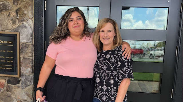
Davis McArthur (left) will soon celebrate his 22nd birthday. Just days before, he received shocking news that his mother, Andrea (right), and sister, Rachel, were both killed in a plane crash in Alaska.
~

WOODSTOCK, Georgia — Davis McArthur will soon celebrate his 22nd birthday. Just days before, he received shocking news that his mother, Andrea, and sister, Rachel, were both killed in a plane crash in Alaska.
"It’s going to be a little different knowing instead of seeing them in a couple days, I’m never going to get to see them," Davis said. "It was basically pure devastation. I didn’t believe it."
Davis said he heard the shocking news from his aunt. Andrea, 55, and Rachel, 20, along with three others were on a sightseeing tour in Southeastern Alaska Thursday. According to the National Transportation Safety Board, the plane went down as the pilot was returning the five passengers to Ketchikan, AK from Misty Fjords National Monument. All six on board were killed.
The victims were identified as pilot Rolf Lanzendorfer, 64, of Cle Elum, Washington, and passengers Mark Henderson, 69, and Jacquelyn Komplin, 60, of Napa, California; Janet Kroll, 77, of Mount Prospect, Illinois and Andrea and Rachel McArthur. The passengers had been on a Holland America Line cruise ship before boarding the plane.
It took two days for crews to recover the bodies, having to navigate around wilderness, steep mountains and bad weather. The NTSB and Federal Aviation Administration are still investigating the cause of the crash.
RELATED: Georgia mother, daughter among 6 killed in Alaska sightseeing plane crash | Here's what we know
"Once we get all that information from the on-scene phase, then we go back and we gather more information, weather information, analyze the maintenance records," Heidi Kemner, NTSB senior air safety investigator, said. "If we need to take off components from the airplane and have them tested we can do that."
Andrea was a flight attendant with Delta for over 30 years and an advocate for her son, who struggled with mental health.
“I'll always remember her warrior-like spirit, always strong no matter what the situation was," Davis said. “If you prune a bush down to nothing, it grows back. You do that so it grows back bigger and better. That’s every time something happened. No matter what it was, she’d come up and go above. She’d rise above.”
Delta released a statement Sunday night, saying: "The Delta family is mourning the loss of one of our own and our hearts and thoughts go out to the many who knew, worked with and admired her.”
Davis said his sister liked horses, nature and adventure. A graduate of Living Science Academy in Woodstock, Rachel had been studying security intelligence at Coastal Carolina University. Davis said she was always willing to help others, just like her mother.
"She always used everything normal people would use an excuse, and she used it to better herself," Davis said. "My mom and sister, they were very dedicated, devout, just always in the church, donating to ministries, donating to good causes and things. I know for a fact my mom and sister are in heaven."

The pilot was Rolf Lanzendorfer, 64, of Cle Elum, Washington.
JUNEAU, Alaska — Foggy and reduced visibility conditions delayed efforts to recover the wreckage of a sightseeing plane that crashed in southeast Alaska, killing six people, a National Transportation Safety Board official said Sunday.
Clint Johnson, chief of the agency’s Alaska region, said efforts to reach the site Sunday were called off due to poor conditions. The team planned to try again Monday, he said.
“However long it takes, we will wait for the weather and wait patiently for it. But we’re going to get this done,” he said.
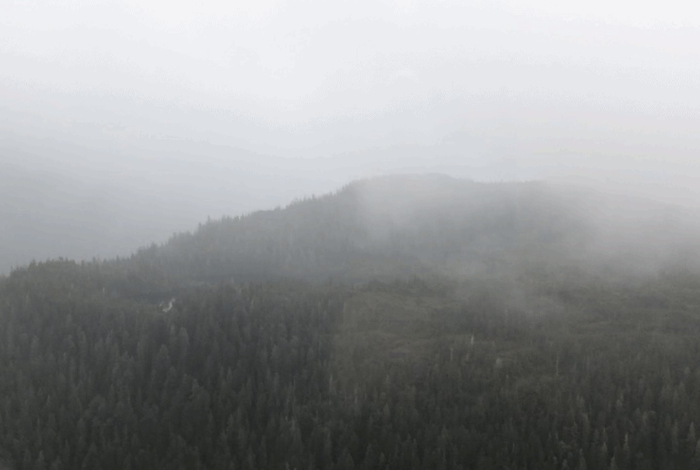
The wreckage was in a rugged, steep area that is heavily forested, at 1,800 feet (548.6 meters) to 2,000 feet (609.6 meters) “up on the side of a mountain,” he said. The site is about 12 miles northeast of Ketchikan, Johnson said.
“Very challenging conditions,” Johnson said, adding that the wreckage would have to be removed by helicopter.
He described conditions at the accident site as having low ceilings, reduced visibility and fog.
Investigators also were conducting interviews in Ketchikan, he said.
The flight was returning to Ketchikan on Thursday from a tour of Misty Fjords National Monument when it crashed, Johnson said.
The plane carried five passengers and the pilot. The Alaska State Troopers identified the pilot as Rolf Lanzendorfer, 64, of Cle Elum, Washington. Troopers identified the passengers as Mark Henderson, 69, and Jacquelyn Komplin, 60, both of Napa, California; Andrea McArthur, 55, and Rachel McArthur, 20, both of Woodstock, Georgia; and Janet Kroll, 77, of Mount Prospect, Illinois.
Troopers and Ketchikan Volunteer Rescue Squad members reached the scene via a chartered helicopter Saturday afternoon and recovered the bodies, which were being taken to the state medical examiner’s office in Anchorage, the troopers said.
Kathleen Grayson, Henderson’s sister, told the Napa Valley Register that Henderson and Komplin had sent messages during their trip “talking about how gorgeous” it was in Alaska. “They were having so much fun,” she said.
Henderson was retired but had worked as a public defender, while Komplin was a registered nurse and instructor at Pacific Union College, the news outlet reported.
Komplin coordinated a wellness program associated with Meals on Wheels for Community Action of Napa Valley, the group’s executive director, Drene Johnson, told The Associated Press. She said Komplin was excited about the trip.
“We were all wishing her well, and that’s what’s so hard for us to comprehend is, now she’s gone,” she said, describing Komplin as “one of a kind.”
One recent post on Kroll’s Facebook page showed Mendenhall Glacier in Juneau in the background. Another was captioned: “I finally made it to Alaska! Hooray!”
Davis McArthur said his mother, Andrea McArthur, and sister, Rachel McArthur, were on a “girls’ trip” before his sister returned to college. He said Andrea McArthur was a flight attendant with Delta Air Lines and that the two women loved traveling and adventure.
Andrea McArthur “had a heart of gold,” he said, adding later: “If there was a need, just know it was going to get met. If you needed somebody to talk to, she was that shoulder to lean on.”
“You could see Jesus in her,” he said.
Rachel McArthur, too, was “always wanting to help out,” he said. She also was independent and strong, he said.
Delta Air Lines released a statement Sunday saying that it was “mourning the loss of one of our own and our hearts and thoughts go out to the many who knew, worked with and admired her.”
Lanzendorfer’s Linkedin profile said he had worked for Southeast Aviation as a pilot since May 2015. Bri Kelly, a media contact for Southeast Aviation, did not provide any details about the pilot’s tenure with the company and directed questions related to the accident to Johnson.
Johnson said Lanzendorfer was the pilot in a July 9 incident in which a Southeast Aviation plane hit an inlet buoy on departure near Coffman Cove and flipped. Alaska State Troopers previously reported the pilot was the only person on board and that no injuries were reported.
Johnson said that’s just “a piece of information that we’re putting on the pile” as investigators probe Thursday’s crash.
The Seattle Times reported that Lanzendorfer had been flying commercial floatplanes for more than 40 years and was described by Clyde Carlson, founder of Washington-based Northwest Seaplanes, as “an excellent pilot.”
Holland America Line confirmed the five passengers on the flight had been traveling on the company’s ship Nieuw Amsterdam, which was nearing the end of seven-day Alaska cruise.
Ketchikan is a popular stop for cruise ships visiting Alaska, and sightseeing excursions, such as those to Misty Fjords National Monument, are among the options for exploring the area while off the ship.
The cruise line said the excursion the passengers were on was not sold by Holland America Line.
Southeast Aviation, in a statement Thursday, said it was cooperating with the agencies involved. “All of us share in the anguish of this tragic incident, and our prayers go out to all affected,” the statement said.
The plane’s emergency beacon was activated about 11:20 a.m. Thursday, the U.S. Coast Guard has said.
A helicopter company reported seeing wreckage on a ridgeline in the search area, and Coast Guard crew members found the wreckage around 2:40 p.m. They reported no survivors, the Coast Guard said.
Weather conditions at the site included mist and light rain, the Coast Guard said.


Another CFIT in AK. FAA needs to adopt more restrictive flight rules for sightseeing missions. Ticket buyers have no idea the amount of risk they are taking. Same with warbird flights.
ReplyDeleteIt is too soon to tell if youtube armchair-guessing based on the weather observations correctly determined that the experienced ATP rated pilot just flew into a ridge that couldn't be seen.
DeleteAugust 6 stories give "about 12 miles northeast of Ketchikan" as the crash location. Run a 12 mile measurement northeast out of Ketchikan and you will notice that 4,000 feet long Buckhorn Lake is in a ridge at that distance.
Original reports on August 5 gave a beacon signal location:
"Coast Guard Petty Officer Eli Teller told the Anchorage Daily News the signal was coming from around 1,400 feet over land and in the area of Buckhorn Lake."
Maybe the beacon story is nothing. But if it turns out that the pilot had visibility to do a Buckhorn Lake flyby for the pax and something happened or he was trying for a lake landing, there will be regrets over the instant assumption without proof of pilot error straight into "rocks in the cloud".
(Search on this string & look at cached text in listings):
"over land and in the area of buckhorn lake"
Or view an unedited August 5 version of the story at:
https://www.newsnationnow.com/us-news/west/coast-guard-searching-for-plane-with-6-on-board-in-alaska/
It doesn't seem to be a lake landing.
ReplyDeletehttps://www.alaskapublic.org/2021/08/09/georgia-mom-and-daughter-among-6-killed-in-plane-crash-near-ketchikan/
NTSB official quote in article: "The wreckage was in a rugged, steep area that is heavily forested, at 1,800 feet to 2,000 feet “up on the side of a mountain,” he said. The site is about 12 miles northeast of Ketchikan, Johnson said."
Looking at the pinned terrain map link below, the ridge 12 miles northeast of Ketchikan has Buckhorn Lake in it. The trough the lake sits in would allow an impressive L-shaped flyby pass for pax.
DeleteThat 12 mile distant location is of interest because when the beacon signal received by the AFRCC triggered the search, the signal location was the area of Buckhorn Lake.
Trouble flying through there could put you on the side of the mountain, or you could fail in an emergency landing approach to the lake if close enough to try.
https://www.google.com/maps/place/Buckhorn+Lake/@55.4502308,-131.4201391,13z/data=!4m13!1m7!3m6!1s0x540c25088729e15b:0x7e90e56bcfc60674!2sKetchikan,+AK+99901!3b1!8m2!3d55.3422222!4d-131.6461112!3m4!1s0x540c1855920665b3:0x195d15c2de1a3015!8m2!3d55.4527974!4d-131.4022552!5m1!1e4
Here is the company that ran the tours/135 operations. On their website, they say they have suspended operations for the foreseeable future.
ReplyDeleteThey offered two sightseeing options to the Misty Fjords area. a 90 minute trip,
Which is a 70 minute sightseeing tour, with a 20 minute water landing stop over.
And, a 2.5 hour trip, which is a 2 hour sightseeing tour, with a 30 minute water landing stop over.
http://southeastaviation.com/index.html (home page)
http://southeastaviation.com/mistyfjords.html (tour description)
Could very well have been a takeoff attempt after the "Mid flight water landing stop over" We just don't have enough info to make that determination at this juncture.
JW
Timing isn't right for the mid flight stop over.
ReplyDeleteFlightaware shows the first minutes of the flight, with ADS-B first seen at 17:43 Z. Crash time of 19:42 Z suggests the plane was near completion of a 2.5 hour flight that pushed off the dock at 17:30 Z.
Showing pax the legendary Mahoney Falls is typically part of these flights. The 2019 N959PA N952DB mid-air crash was Misty Fjords flightseeing planes that had overflown the Buckhorn Lake area moments before the collision in the vicinity of Mahoney Falls.
Misty Fiords flightseeing return routes from the stop over are shown in Figure 1 of the report from the 2019 mid-air crash:
https://www.ntsb.gov/investigations/AccidentReports/Reports/AAR2104.pdf
Overflying terrain around Buckhorn Lake appears to be routine routing for these flights due to the Mahoney Falls viewing objective.
Initial flight track:
https://flightaware.com/live/flight/N1249K/history/20210805/1743Z
NTSB animation of mid-air at Mahoney Lake (see 8:18 - 8:38):
https://youtu.be/mT1omo5jBqs?t=498
"Light mist and rain." Sounds like he was doing scud running.
ReplyDeletePrelim is out, describes low clouds in the area, crash was 18 miles NE, not 12.
ReplyDeletehttps://data.ntsb.gov/carol-repgen/api/Aviation/ReportMain/GenerateNewestReport/103647/pdf
The Carol report always contains errors. It also says in the Info section that the location is 16 N/M NE of Ketchikan. If you take the "reported" lon/lat of 55.482583,-131.22532, and use google measure it shows a distance of about 20.5 miles to the center of the Harbor. There is a mixture of Nautical and statute miles in the reports.
Deletehttps://www.google.com/maps/place/55%C2%B028'57.3%22N+131%C2%B013'31.2%22W/@55.3817453,-131.5802397,33275m/data=!3m1!1e3!4m5!3m4!1s0x0:0x0!8m2!3d55.4825833!4d-131.2253333?hl=en
The "not 12" refers to NTSB's Chief Johnson's incorrect 12 mile number given in news reports.
DeleteIt was measuring on google maps using that incorrect 12 mile number that seemed to validate the also incorrect Coast Guard statement that the ELT signal was in the area of Buckhorn Lake.
. GPS positioning in Alaska can be off by 100s to 1000s of feet both horizontally and vertically. Charts can also be off by that much. Evidence of this has been presented to the FAA, NTSB and other branches of the federal government. They all ignore it and argue gps is accurate to 50 feet, disregarding their own and industry publications, as well as pilot and passenger testimony, and photographic evidence. There are even multiple university studies on this problem...
ReplyDeleteUntil the govt. acknowledges the errors in charts and gps, and inform the piloting public these sorts of accidents will continue. Navigating in bad weather/weather turning bad, using gps and its terrain features to avoid the hills or mountains is a recipe for crashing. GPS equipped airplanes continue to hit the sides of mountains and hills in Alaska in bad weather. We don't know why he hit the mountain but this is a very possible reason. The us government(faa ntsb federal prosecutors office) is trying to make the portable uncertified garmin 196 land/sea/air gps (software version 3.7) a legal standard of altitude recording. They argue it is always accurate to 50 feet. This gps is allowed to guess at altitudes when it has a 2 dimensional position. It has even recorded a car at over 4000 feet msl descending to 430 feet msl then climbing back up to over 800 feet msl while driving in downtown Fairbanks(elevation less than 450 feet msl). Other garmin products have the same/similar problems with altitude and horizontal positioning. These are programing problems and delayed/accelerated satellite signal problems. The signal problems are caused by terrain and atmospheric, ionospheric and space-based disturbances as well as antennae placement mostly..
WAAS was created and implemented to help correct gps errors but it does not cover all areas of Alaska with correction information and is sometimes wrong.Some programs will use the wrong waas correction signal. The military has their own correction systems and are working on several new correction systems. The Map Alaska Initiative was created to remap Alaska to modern standards not the 300 meter and 1 Kilometer accuracy standards in use for Alaska for decades.
I suspect this is another Technology Induced Fatal Crash or TFIC not CFIT
. GPS positioning in Alaska can be off by 100s to 1000s of feet both horizontally and vertically. Charts can also be off by that much. Evidence of this has been presented to the FAA, NTSB and other branches of the federal government. They all ignore it and argue gps is accurate to 50 feet, disregarding their own and industry publications, as well as pilot and passenger testimony, and photographic evidence. There are even multiple university studies on this problem...
ReplyDeleteUntil the govt. acknowledges the errors in charts and gps, and inform the piloting public these sorts of accidents will continue. Navigating in bad weather/weather turning bad, using gps and its terrain features to avoid the hills or mountains is a recipe for crashing. GPS equipped airplanes continue to hit the sides of mountains and hills in Alaska in bad weather. We don't know why he hit the mountain but this is a very possible reason. The us government(faa ntsb federal prosecutors office) is trying to make the portable uncertified garmin 196 land/sea/air gps (software version 3.7) a legal standard of altitude recording. They argue it is always accurate to 50 feet. This gps is allowed to guess at altitudes when it has a 2 dimensional position. It has even recorded a car at over 4000 feet msl descending to 430 feet msl then climbing back up to over 800 feet msl traveling thru houses while driving in downtown Fairbanks(elevation less than 450 feet msl). Other garmin products have the same/similar problems with altitude and horizontal positioning. These are programing problems and delayed/accelerated satellite signal problems. The signal problems are caused by terrain and atmospheric, ionospheric and space-based disturbances as well as antennae placement among pther things..
WAAS was created and implemented to help correct gps errors but it does not cover all areas of Alaska with correction information and is sometimes wrong.. The military has their own correction systems and are working on several new correction systems. The Map Alaska Initiative was created to remap Alaska to modern standards not the 300 meter and 1 Kilometer accuracy standards in use for Alaska for decades.
I suspect this is another Technology Induced Fatal Crash or TFIC not CFIT
Sightseeing flights are performed under visual flight rules, where GPS and map accuracy limitations are not going to cause a CFIT unless you continue into IMC.
DeleteThe Weather Camera Program mentioned in the FAASI FY21 Final Report can be expanded into the tour area to provide the necessary visibility to tour operators before turning into a leg of the tour routes that limits turning back to escape IMC. Cruise ship companies might want to step up and partner with the air operators to fund that. The lack of cameras there is just an ongoing business failure of the tourism industry.
FAASI FY21 Final Report:
https://www.faa.gov/sites/faa.gov/files/2021-10/FAA%20Alaska%20Safety%20Initiative%20Report%20-%20final.pdf
The GPS altitude error you noted in automobiles is not relatable to aviation - if those cars had pressure altimeters in the dash panel, they wouldn't have gotten altitude errors driving in between buildings in Fairbanks.
Re-mapping the huge state is not being ignored. Moving map displays will get the updated mapping info from the Alaska Mapping Initiative in 2022, as detailed in the link below:
https://www.usgs.gov/core-science-systems/ngp/user-engagement-office/alaska-mapping
I miss mom and rae.... Had the memorial service aug 12 a day after my 22 birthday
ReplyDeleteI bet you do. Your mother looks upon you and is proud of you for carrying on. Be strong.
DeleteI’m holding you in my heart, Davis, along with your mom and your sister. I am so very sorry for your loss.
Delete