


The National Transportation Safety Board traveled to the scene of this accident.
Additional Participating Entities:
Federal Aviation Administration / Flight Standards District Office; Helena, Montana
Textron Aviation; Wichita, Kansas
Lycoming Engines; Williamsport, Pennsylvania
Investigation Docket - National Transportation Safety Board:
Location: Billings, Montana
Accident Number: WPR20FA063
Date and Time: January 11, 2020, 18:01 Local
Registration: N736YU
Aircraft: Cessna TR182
Aircraft Damage: Destroyed
Defining Event: Controlled flight into terr/obj (CFIT)
Injuries: 4 Fatal
Flight Conducted Under: Part 91: General aviation - Personal
On January 11, 2020, at 1801 mountain standard time, a Cessna TR182 airplane, N736YU, was destroyed when it was involved in an accident near Billings, Montana. The pilot and three passengers were fatally injured. The airplane was operated as a Title 14 Code of Federal Regulations (CFR) Part 91 instructional flight.
The pilot’s wife reported that her husband planned to fly about 1630 and was expected to return to his home about 1730. According to Automatic dependent surveillance-broadcast (ADS-B) data, following its departure from Billings Logan International Airport (BIL), Billings, Montana, the airplane landed at Big Horn County Airport (00U), Hardin, Montana about 1715 and subsequently departed about 1740. Flight data retrieved from a multi-function display (MFD) on the airplane showed that the airplane began an immediate climb after it departed 00U and established its cruise altitude, about 4,796 ft msl at 1747:43 and maintained a similar altitude and a height above terrain (between 1,400 and 2,100 ft agl) for the remainder of the flight.
According to ADS-B data, the airplane then flew a straight track northwest towards Roundup, Montana (about 269° magnetic) until about 1753:53 when the airplane made a slight left turn to 257° and continued along this heading for the remainder of the recording. MFD data showed rising terrain about 40 seconds before the airplane crashed. The airplane was at an altitude of 4,954 ft msl (35 ft agl) when the data ended at 1801:22 about 1/2 nautical mile from the airplane’s initial impact point. The pilot’s wife contacted local law enforcement about 2000 when he did not return home.
According to the participants who flew with the accident pilot, he normally flew about 1,000 ft agl level over terrain and would use the autopilot “altitude hold” function for many flights. They also observed that he did not fly with a Federal Aviation Administration sectional chart as he relied mostly on the map on his MFD for terrain and chart information.
According to the accident pilot’s business partner, based on a photograph taken by one of the rear seat passengers that had been sent to her during the accident flight, the accident pilot was in the right seat of the airplane during the accident flight. According to those who flew with the pilot, during these flights he would allow his passengers to fly the airplane from the left seat if they chose to and they would typically fly anywhere between 4,000 and 5,000 ft msl to destinations south, east, and north of the airport.
A passenger who flew with the accident pilot about one week prior to the accident reported that they flew to 00U, but then flew south and circled a landmark before returning to BIL. During the flight, they maintained an altitude of about 1,000 ft agl and used the autopilot for one leg of the flight. A review of other flight data retrieved from the MFD showed that the pilot typically flew at altitudes between about 1,000 and 2,000 ft agl during these flights.
The MFD flight data also showed that the pilot completed a leg from 00U to Roundup Airport (RPX), Roundup, Montana, several days before the accident. This track showed the airplane depart 00U about 1653 and flew a similar course as the accident flight. During cruise flight, the airplane passed within 0.3 nautical mile of the 185-ft radio tower that it impacted on the day of the accident. This part of the flight occurred at 1716 during cruise flight at an altitude of 4,680 ft msl (580 ft agl). The flight landed at RPX about 15 minutes later.
Pilot Information
Certificate: Airline transport; Commercial; Flight instructor
Age: 69, Male
Airplane Rating(s): Single-engine land; Multi-engine land
Seat Occupied: Right
Other Aircraft Rating(s): Glider; Helicopter
Restraint Used: Unknown
Instrument Rating(s): Airplane
Second Pilot Present: No
Instructor Rating(s): Airplane single-engine; Instrument airplane
Toxicology Performed: Yes
Medical Certification: Class 2 With waivers/limitations
Last FAA Medical Exam: August 7, 2018
Occupational Pilot: No
Last Flight Review or Equivalent:
Flight Time: 13800 hours (Total, all aircraft)
The co-owner of the accident airplane, who knew the accident pilot for 47 years, stated that the pilot started flying in 1972, that he did most of his flying and flight instructing in Billings, and was familiar with the area.
According to the pilot’s wife, the pilot was well rested on the day of the accident and did not exhibit any abnormal behavior that day or in the days that preceded the accident.
Aircraft and Owner/Operator Information
Aircraft Make: Cessna
Registration: N736YU
Model/Series: TR182 No Series
Aircraft Category: Airplane
Year of Manufacture: 1978
Amateur Built:
Airworthiness Certificate: Normal
Serial Number: R18200792
Landing Gear Type: Retractable - Tricycle
Seats: 4
Date/Type of Last Inspection: January 3, 2019 Annual
Certified Max Gross Wt.: 3100 lbs
Time Since Last Inspection:
Engines: 1 Reciprocating
Airframe Total Time: 3101.6 Hrs
Engine Manufacturer: Lycoming Engines
ELT: Installed
Engine Model/Series: O-540-L3C5D
Registered Owner:
Rated Power: 235 Horsepower
Operator:
Operating Certificate(s) Held: None
The airplane was equipped with an Aspen Evolution primary flight display (PFD and a Garmin GTN750 MFD. The Aspen Evolution was installed in front of the left seat occupant and drew barometric altitude information from its own internal air data computer, displaying that information on a digital tape on the right side of the display. The barometric altitude was adjustable by altimeter setting, which was displayed below the altitude tape. According to the Aspen installation manual, the altitude tape display should be within 40 ft of the calibrated test altitude. The altimeter setting at the time of the accident could not be determined as the Aspen unit did not record data. An Aspen MFD was located next to the PFD that was mounted to the instrument panel in front of the left seat occupant. Likewise, this unit did not record data.
The GTN750 was a touchscreen MFD mounted on the center instrument panel that was equipped with an obstacle range option and topography overlay available on the unit’s map page. According to a representative of the MFD manufacturer, the GPS altitude or “GSL” altitude, which is computed by satellite geometry, would have been displayed in the top left corner of the MFD’s map page. According to the Garmin pilot’s guide, the obstacle range could display unlighted obstacles below 1,000 ft agl. A representative from Garmin stated that the obstacle range would not have displayed obstructions below 200 ft agl.
The GTN750 also recorded pressure altitude and barometric altitude that was taken from the Aspen air data computer. The last data point recorded showed the barometric altitude was 4,954 ft msl and the GPS altitude was 4,747 ft GSL about the time of the accident.
Meteorological Information and Flight Plan
Conditions at Accident Site: Visual (VMC)
Condition of Light: Night
Observation Facility, Elevation: 3662 ft msl
Distance from Accident Site: 27 Nautical Miles
Observation Time: 17:53 Loca
l Direction from Accident Site: 180°
Lowest Cloud Condition: Few / 12000 ft AGL
Visibility: 10 miles
Lowest Ceiling: Broken / 16000 ft AGL
Visibility (RVR):
Wind Speed/Gusts: 14 knots /
Turbulence Type Forecast/Actual: /
Wind Direction: 240°
Turbulence Severity Forecast/Actual: /
Altimeter Setting: 29.65 inches Hg
Temperature/Dew Point: -1°C / -10°C
Precipitation and Obscuration: No Obscuration; No Precipitation
Departure Point: Hardin, MT (00U)
Type of Flight Plan Filed: None
Destination: Roundup, MT (RPX)
Type of Clearance: VFR flight following
Departure Time: 17:40 Local
Type of Airspace: Class E
Wreckage and Impact Information
Crew Injuries: 1 Fatal
Aircraft Damage: Destroyed
Passenger Injuries: 3 Fatal
Aircraft Fire: None
Ground Injuries:
Aircraft Explosion: None
Total Injuries: 4 Fatal
Latitude, Longitude: 46.232498,-108.36555
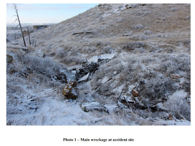
The airplane wreckage was located in mountainous terrain at an elevation of about 4,252 ft msl. All major sections of the airplane were accounted for at the accident site. The initial impact point was marked by several bent cross members and a broken guy wire about 65 ft high (4,809 ft msl) on an about 185-ft-tall radio tower, which was located on a peak with a field elevation of about 4,744 ft msl. Several sections of the outboard left wing (not shown in figure 1) were located about 100 ft north of the tower, and two pieces displayed longitudinal signatures consistent with impacting a wire. The remaining section of the left wing was found in the debris path about 350 ft from the main wreckage. Several airframe and engine fragments were distributed along the energy path, which was oriented on a heading of about 295º. The main wreckage was found about 1,450 ft northwest of the initial impact point in a coulee and included the right wing, fuselage, empennage, and engine. A 5-ft intermediate ground scar was located about 250 ft beyond the main wreckage.
The left wing was fragmented, and some sections were found near the tower. The control cables to the rudder, aileron, and elevator were recovered but exhibited multiple overload failures. The flap motor actuator measured 0.1 inch, consistent with a retracted flap position.
The engine crankshaft could only be partially rotated due to damage sustained during the impact. The ignition system displayed signatures consistent with normal operation and wear. Internal inspection of the case did not reveal any indications of oil starvation. The cylinder combustion chambers remained mechanically undamaged, and there was no evidence of foreign object ingestion or detonation.
Additional Information
Tower
According to FAA Advisory Circular 70/7460-1L, under Chapter 2.1 “Structures to be Marked or Lighted”:
“Any temporary or permanent structure, including all appurtenances, that exceeds an overall height of 200 feet above ground level or exceeds any obstruction standard contained in 14 CFR Part 77 should be marked and/or lighted. However, an FAA aeronautical study may reveal that the absence of marking and/or lightning will not impair aviation safety. Conversely, the object may present such an
extraordinary hazard potential that higher standards may be recommended for increased conspicuity to ensure aviation safety.”
The excerpt continues to describe FAA action on structures that are less than 200 ft agl: “The FAA may also recommend marking and/or lighting a structure that does not exceed 200 ft above ground level or 14 CFR Part 77 standards because of its particular location.”
An FAA sectional chart valid from September 12, 2019, to March 26, 2020, did not list the tower as an obstacle. The FAA sectional chart legend lists the lowest obstruction marked on the sectional chart as “above 200 ft agl.” The maximum elevation figure for the sector of the sectional chart where the accident occurred was 5,100 ft msl.
Regulations for Obstructions and Minimum Safe Altitudes
According to 14 CFR 97.17, which contains the obstruction standards for navigable airspace:
“An existing object…would be an obstruction to air navigation if it is of greater height than any of the following heights or surfaces… (2) A height that is 200 ft AGL or above the established airport elevation…”
Title 14 CFR 91.119 provides the general minimum safe altitudes for operating an aircraft. According to the regulation:
“Except when necessary for takeoff and landing, no person may operate an aircraft below the following altitudes… (c) Over other than congested areas. An altitude of 500 feet above the surface, except over open water or sparsely populated areas. In those cases, the aircraft may not be operated closer than 500 feet to any person, vessel, vehicles, or structure.”
==========
Location: Billings, MT
Accident Number: WPR20FA063
Date & Time: 01/11/2020, 1801 MST
Registration: N736YU
Aircraft: Cessna TR182
Injuries: 4 Fatal
Flight Conducted Under: Part 91: General Aviation - Personal
On January 11, 2020, about 1801 mountain standard time, a Cessna TR182 airplane, N736YU, was destroyed when it collided with mountainous terrain near Billings, Montana. The airline transport pilot and three passengers were fatally injured. The airplane was registered to and operated by the pilot as a Title 14 Code of Federal Regulations Part 91 personal flight. Visual meteorological conditions prevailed and a flight plan was not filed for the cross-county flight, which departed Billings Logan International Airport (BIL), Billings, Montana at 1656.
According to a family member, the pilot had planned a recreational flight from BIL with intermediate stops in Hardin, Montana and Roundup, Montana and was expected to return to his home about 1930. Preliminary radar information obtained from a commercially available source was consistent with the family member's recount of the pilot's flight path. Following its departure from BIL, the airplane landed in Hardin about 1715 and subsequently departed about 1740. The radar track indicated that the airplane flew a straight track towards Roundup until the track ceased at 1801, about 700 ft from the accident site.
The airplane was located in mountainous terrain at an elevation of about 4,252 ft mean sea level. All major sections of the airplane were accounted for at the accident site. The initial impact point (IIP) was marked by several bent cross members and a broken guy wire about 65 ft high on an approximate 185 foot-tall radio tower. Several sections of the outboard left wing were located about 100 ft north of the tower and two pieces displayed longitudinal signatures consistent with impacting a wire. The remaining section of left wing was found in the debris path about 350 ft from the main wreckage. Several airframe and engine fragments were distributed along the energy path, which was oriented on a heading of about 295º magnetic. A 5 foot-long intermediate ground scar was located about 250 ft from the main wreckage, which was found about 1,450 ft northwest of the IIP in a coulee and comprised of the right wing, fuselage, empennage, and engine.
The airplane has been retained for further examination.
Aircraft and Owner/Operator Information
Aircraft Make: Cessna
Registration: N736YU
Model/Series: TR182 No Series
Aircraft Category: Airplane
Amateur Built: No
Operator:
Operating Certificate(s) Held: None
Meteorological Information and Flight Plan
Conditions at Accident Site: Visual Conditions
Condition of Light: Night
Observation Facility, Elevation: , 3662 ft msl
Observation Time: 1753 MST
Distance from Accident Site: 27 Nautical Miles
Temperature/Dew Point: -1°C / -10°C
Lowest Cloud Condition: Few / 12000 ft agl
Wind Speed/Gusts, Direction: 14 knots / , 240°
Lowest Ceiling: Broken / 16000 ft agl
Visibility: 10 Miles
Altimeter Setting: 29.66 inches Hg
Type of Flight Plan Filed:
Departure Point: Hardin, MT (00U)
Destination: Roundup, MT (RPX)
Wreckage and Impact Information
Crew Injuries: 1 Fatal
Aircraft Damage: Destroyed
Passenger Injuries: 3 Fatal
Aircraft Fire: None
Ground Injuries: N/A
Aircraft Explosion: None
Total Injuries: 4 Fatal
Latitude, Longitude: 46.232500, -108.365556


For Mikel Peterson, January 11th was supposed be a chance at a better life.
Since he was a teenager in Billings, Peterson, 35, had struggled with addiction. Within the last few months his older sister Stacie Peterson said she noticed a change in her younger brother, as he talked with increasing seriousness about his desire to get into a sober living home.
The chance came for him to move into one in Billings. Peterson had been sober "for some time," but he felt this was the extra push he needed to stay that way, his mother Sue Alexander Pruitt said.
That Saturday he came down to Billings from the home of his mother, Sue Alexander Pruitt, in Forsyth, where he had been staying since around Thanksgiving.
“He was really excited to have this chance,” his sister said. “And he was ready.”
Mikel Peterson was starting to move into the house in Billings on Saturday when he and two other men in the house had the chance to take a ride in an airplane with David Healow, a Billings doctor, pilot and certified flight instructor who was decades into his own recovery.
All four men, brought together by sobriety and the chance it offered to improve their lives, died January 11th in a plane crash north of Billings.
“I want people to know that these guys were changing their life,” Stacie Peterson said. “They had taken that step to do that. They’re not just a name.”
Healow, the 69-year-old pilot of the group, was an anesthesiologist, father, foster parent and Alcoholics Anonymous member for 33 years.
“His recent passion was to provide safe, sober housing for anyone in need,” his obituary said.
Raymond Rumbold, 32, had been sober for about a year, his friend Rob Boag said. Rumbold worked construction and had been trying to reconnect with his daughter.
“We were all really proud for him,” Boag said. “The story just kind of stopped, you know? Terribly tragic, definitely. None of us expected it. Everybody that knows him was like ‘He was doing so good. He was doing so good.’”
Rusty Jungels, 36, had proudly posted on social media about his milestones in sobriety, his aunt Debbie Greenwalt told The Gazette. Jungels outlived both of his parents. Greenwalt said her nephew had been sober for more than 120 days, had been working in the food service industry, and had three children.
“He wanted to be a part of his children’s life and was working to achieve that,” she said. “We loved him very much and we’ll miss him.”
The most recent National Survey on Drug Use and Health found that in the United States an estimated 21.2 million people 12 and older needed substance abuse treatment in 2018. Of those 21.2 million people the survey estimates around 90 percent did not receive specialty treatment for their substance abuse disorders.
As the days have passed since the crash, new hardships have continued to emerge for those who knew the men who died.
Stacie Peterson said she is trying to support her own sons while dealing with her grief. For her 6-year-old, “Uncle Mike” was a hero who often went away but always came back. Her teenage son learned how to drive a manual transmission from his uncle because she didn’t have the patience but Mikel did, Stacie Peterson said. Remembering it makes her laugh.
Her brother was the kind of person who could fix anything — mechanical or otherwise — even if he didn’t quite know how to from the outset. Working with concrete was something he always enjoyed. People teased him for all the time and money he put into restoring his treasured classic Chevy truck. He loved to work on bicycles and ride them, painting them lime green so they’d be visible on the road.
“He did all the remodeling on my house after the storms, you know, so everywhere I look, I see him,” Peterson said.
Mikel Peterson didn't just help out his sister with her home. He served in the National Guard and was among those who helped amid Hurricane Katrina, his mother Sue Pruitt said.
Several years ago he had been sober for a few years, but his sister said he relapsed after the death of their father in 2013, sending him into a spiral with methamphetamine.
“And we’ve been fighting to get him back ever since,” she said. “You know, he was so funny, and he had the best personality. I mean, when he was sober, I don’t know anybody who wouldn’t want to be around him.”
His mother said no one was more loved in their family, and that she had been a rock to her son.
Pruitt recalled the last thing they said to each other when he left her house Saturday morning before heading to Billings.
"He gave me a hug and said 'Mom don't worry, I've got it this time.' And I told him 'I know you do' and he said 'I love you mom and 'I told him I loved him too,'" she said. "I'll always remember that last 'I love you.'"
In Rumbold’s case, he was already starting to try to help other people through their own struggles with addiction, Boag said. The two first met as roommates about seven years ago, and Boag remembered his friend as someone who enjoyed being outdoors, riding motorcycles and four-wheelers, shooting guns and spending time with friends.
Boag went through his own struggles with addiction, which motivated him to help Rumbold, who also went by the name Ray Linney. Boag said his friend had a drug addiction and went through a traumatic incident shortly before he started becoming serious about trying to get sober.
"He looked at me and he's like 'I'm going to die if I keep doing this,'" Boag said.
What Boag did for his friend wasn't part of any official program, but the kindness he showed his friend made an impression on Rumbold.
“He felt an obligation to struggling addicts to reach out and to try to help them,” Boag said. “ ... Especially so early in his sobriety ... it was very uplifting to know he didn’t just look internally. He didn’t just get on with his life.”
Rumbold sent Boag a Facebook message that arrived in Boag's inbox at around 5 p.m. the day of the crash. The message mentioned flying and included a 19-second video from inside an airplane.
The video begins with Rumbold in the backseat of an airplane nodding calmly before flipping the camera to look outside the window. The camera briefly passes over the front seat of the plane and glowing screens of the instrument panel before being pointed outside again. For its final six seconds the video shows the pale horizon and the partially snow-covered ground below.
Rumbold promised to tell Boag more about it later that day. He never got the chance.
The plane may have crashed at around 6 p.m. January 11th, according to a Federal Aviation Association estimate based on last contact with the plane. It had left Hardin with Billings as its destination at about 5:40 p.m., according to the FAA.
The plane apparently struck a guy wire from an approximately 200-foot radio tower on Dunn Mountain between Billings and Roundup, Yellowstone County Sheriff Mike Linder said.
“It’s like a part of me went too,” Boag said of his friend's death. “I felt like I had mirrored a lot of myself into him in order to grow him. He got all those skills and didn’t really get to put them to use.
“It’s heartbreaking.”
Story and video ➤ https://helenair.com


The four people killed in an airplane crash about 25 miles north of Billings over the weekend were identified Monday by the Yellowstone County Sheriff's Office.
The victims included David Healow 69; Rusty Jungles, 36; Mikel Peterson, 35; Raymond Rumbold 32.
All four were from Billings. Healow was listed as the pilot, said Sheriff Mike Linder in a press release issued early Monday night.
As autopsies were performed Monday, officials pressed on with their investigation into the crash believed to have occurred Saturday evening. The wreckage and the victims were discovered Sunday morning in a remote area among coulees between Billings and Roundup.
Linder said Sunday the plane appeared to have hit a guy wire connected to a roughly 200-foot radio tower on Dunn Mountain and then tumbled to the base of the mountain's west-facing slope.
Monday afternoon an FAA spokesperson said it's believed the plane left Hardin at about 5:40 p.m. with Billings as its destination. The estimated time of the plane crash is 6 p.m. That time is determined by last contact with FAA Flight Services, either through radar or voice communications, FAA spokesperson Allen Kenitzer said by email.
The lead agency on the investigation is the National Transportation Safety Board. The NTSB works with the FAA, the engine manufacturer and the airplane manufacturer during its investigations, according to NTSB public information officer Terry Williams.
Monday morning the sheriff's office transported NTSB and FAA investigators to the scene of the crash, according to Linder. They spent most of the day at the crash site before returning to Billings at about 4:30 p.m.
During its investigation, the NTSB will look into a variety of factors including the crash site, the aircraft, the engine, the pilot's history, the maintenance of the aircraft and the environment, including the weather, said Williams, the NTSB information officer.
Investigators typically visit the crash site and at some point the airplane will be moved to "a more secure location for a more thorough examination," Williams said.
A preliminary NTSB report is generally issued seven to 10 days after a crash, but that report won't include a determination of cause or analysis, according to Williams.
Among limited information about the crash on the FAA's website is the plane's tail number: N736YU.
That tail number comes back on the FAA's online aircraft registry to a 1978 Cessna TR182, a fixed-wing single-engine plane. The plane's status is listed online as valid, with a certification issued in March 2018 set to expire in March 2021. Cessna 182 airplanes typically seat up to four people.
Of the four crash victims, Healow is the only one whose name turned up on the FAA's online Airmen database. According to FAA records Healow was certified as an airline transport pilot, flight instructor and ground instructor.
An initial alert notice for a search for a missing aircraft was issued at about 3 a.m. Sunday, according to the FAA. The sheriff's office then began working to locate the plane. A radar track was used to find a rough location of the crash site, after which its exact location was discovered by flying over the area in a helicopter piloted by Al Blain of Billings Flying Service.
The Montana Highway Patrol, Shepherd Volunteer Fire Department and Musselshell County Sheriff's Office all assisted in the recovery effort Sunday.
Original article can be found here ➤ https://billingsgazette.com David

Husband, dad, son, brother, friend, healer, mentor, mechanic, wind hippie, pilot, raconteur, contrarian, intellectual, plebeian, Renaissance Man.
Dave answered to Mr. Science, Pig, Three Dog Dave, numerous variations on those themes and countless other sobriquets. He would, and sometimes literally did, give a brother the Hawaiian shirt off his back. Dave left us too soon but he died doing something he loved while trying to give back. May we all be so lucky when the time comes.
David Gregory Healow was born on April 28, 1950, in Billings, Montana. He was the third child of six born to Tony and Jessie Healow. He attended school in Billings and graduated from Senior High in 1968. After graduating from college at the U of M in Missoula, Dave moved to Choteau, Montana, to fly his new crop duster. He had earned his private pilot license when he was 16, completed flight instructor training and glider pilot training during college. He taught flying in Choteau, Montana, and worked as a crop duster for four years. Then he got the wild idea that he should go to medical school. While in medical school at the university of New Mexico, he completed his commercial pilot rating and flew for Crown Airlines on the weekends. He completed his residency at the Mayo Clinic in Rochester, Minnesota, in June of 1983, specializing in anesthesiology. Then he began practicing medicine in Billings and continued to do so until his death.
He was preceded in death by his parents, his brother, Don and his nephew David Donald Healow. He is survived by his wife of 42 years, Connie Oser, and his three children: Alec Healow, Hugh Healow and Sheilah Healow (Jeremy Dudley). He is also survived by his siblings: Rita Ryan (Mike), Steve Healow (Cathy), Jim Healow (Linda), Terry Healow (Deb Whitcomb) and Don’s wife Jan Healow. He also leaves behind numerous nieces and nephews whom he adored. And we can’t forget his three dogs: Kayla, Daisy and Buddy.
Dave had many passions. He adored his children: biological, foster and strays. His biggest accomplishment was learning how to live in recovery. He had been an active and passionate member of Alcoholics Anonymous for 33 years. His recent passion was to provide safe, sober housing for anyone in need.
Memorials may be made to a charity of your choice.
Please join us on Sunday, Jan. 19, at 2 p.m. We will be celebrating Dave’s life at the Billings Elks Club, 934 Lewis Avenue.
Accident Number: WPR20FA063
Date & Time: 01/11/2020, 1801 MST
Registration: N736YU
Aircraft: Cessna TR182
Injuries: 4 Fatal
Flight Conducted Under: Part 91: General Aviation - Personal
On January 11, 2020, about 1801 mountain standard time, a Cessna TR182 airplane, N736YU, was destroyed when it collided with mountainous terrain near Billings, Montana. The airline transport pilot and three passengers were fatally injured. The airplane was registered to and operated by the pilot as a Title 14 Code of Federal Regulations Part 91 personal flight. Visual meteorological conditions prevailed and a flight plan was not filed for the cross-county flight, which departed Billings Logan International Airport (BIL), Billings, Montana at 1656.
According to a family member, the pilot had planned a recreational flight from BIL with intermediate stops in Hardin, Montana and Roundup, Montana and was expected to return to his home about 1930. Preliminary radar information obtained from a commercially available source was consistent with the family member's recount of the pilot's flight path. Following its departure from BIL, the airplane landed in Hardin about 1715 and subsequently departed about 1740. The radar track indicated that the airplane flew a straight track towards Roundup until the track ceased at 1801, about 700 ft from the accident site.
The airplane was located in mountainous terrain at an elevation of about 4,252 ft mean sea level. All major sections of the airplane were accounted for at the accident site. The initial impact point (IIP) was marked by several bent cross members and a broken guy wire about 65 ft high on an approximate 185 foot-tall radio tower. Several sections of the outboard left wing were located about 100 ft north of the tower and two pieces displayed longitudinal signatures consistent with impacting a wire. The remaining section of left wing was found in the debris path about 350 ft from the main wreckage. Several airframe and engine fragments were distributed along the energy path, which was oriented on a heading of about 295º magnetic. A 5 foot-long intermediate ground scar was located about 250 ft from the main wreckage, which was found about 1,450 ft northwest of the IIP in a coulee and comprised of the right wing, fuselage, empennage, and engine.
The airplane has been retained for further examination.
Aircraft and Owner/Operator Information
Aircraft Make: Cessna
Registration: N736YU
Model/Series: TR182 No Series
Aircraft Category: Airplane
Amateur Built: No
Operator:
Operating Certificate(s) Held: None
Meteorological Information and Flight Plan
Conditions at Accident Site: Visual Conditions
Condition of Light: Night
Observation Facility, Elevation: , 3662 ft msl
Observation Time: 1753 MST
Distance from Accident Site: 27 Nautical Miles
Temperature/Dew Point: -1°C / -10°C
Lowest Cloud Condition: Few / 12000 ft agl
Wind Speed/Gusts, Direction: 14 knots / , 240°
Lowest Ceiling: Broken / 16000 ft agl
Visibility: 10 Miles
Altimeter Setting: 29.66 inches Hg
Type of Flight Plan Filed:
Departure Point: Hardin, MT (00U)
Destination: Roundup, MT (RPX)
Wreckage and Impact Information
Crew Injuries: 1 Fatal
Aircraft Damage: Destroyed
Passenger Injuries: 3 Fatal
Aircraft Fire: None
Ground Injuries: N/A
Aircraft Explosion: None
Total Injuries: 4 Fatal
Latitude, Longitude: 46.232500, -108.365556

For Mikel Peterson, January 11th was supposed be a chance at a better life.
Since he was a teenager in Billings, Peterson, 35, had struggled with addiction. Within the last few months his older sister Stacie Peterson said she noticed a change in her younger brother, as he talked with increasing seriousness about his desire to get into a sober living home.
The chance came for him to move into one in Billings. Peterson had been sober "for some time," but he felt this was the extra push he needed to stay that way, his mother Sue Alexander Pruitt said.
That Saturday he came down to Billings from the home of his mother, Sue Alexander Pruitt, in Forsyth, where he had been staying since around Thanksgiving.
“He was really excited to have this chance,” his sister said. “And he was ready.”
Mikel Peterson was starting to move into the house in Billings on Saturday when he and two other men in the house had the chance to take a ride in an airplane with David Healow, a Billings doctor, pilot and certified flight instructor who was decades into his own recovery.
All four men, brought together by sobriety and the chance it offered to improve their lives, died January 11th in a plane crash north of Billings.
“I want people to know that these guys were changing their life,” Stacie Peterson said. “They had taken that step to do that. They’re not just a name.”
Healow, the 69-year-old pilot of the group, was an anesthesiologist, father, foster parent and Alcoholics Anonymous member for 33 years.
“His recent passion was to provide safe, sober housing for anyone in need,” his obituary said.
Raymond Rumbold, 32, had been sober for about a year, his friend Rob Boag said. Rumbold worked construction and had been trying to reconnect with his daughter.
“We were all really proud for him,” Boag said. “The story just kind of stopped, you know? Terribly tragic, definitely. None of us expected it. Everybody that knows him was like ‘He was doing so good. He was doing so good.’”
Rusty Jungels, 36, had proudly posted on social media about his milestones in sobriety, his aunt Debbie Greenwalt told The Gazette. Jungels outlived both of his parents. Greenwalt said her nephew had been sober for more than 120 days, had been working in the food service industry, and had three children.
“He wanted to be a part of his children’s life and was working to achieve that,” she said. “We loved him very much and we’ll miss him.”
The most recent National Survey on Drug Use and Health found that in the United States an estimated 21.2 million people 12 and older needed substance abuse treatment in 2018. Of those 21.2 million people the survey estimates around 90 percent did not receive specialty treatment for their substance abuse disorders.
As the days have passed since the crash, new hardships have continued to emerge for those who knew the men who died.
Stacie Peterson said she is trying to support her own sons while dealing with her grief. For her 6-year-old, “Uncle Mike” was a hero who often went away but always came back. Her teenage son learned how to drive a manual transmission from his uncle because she didn’t have the patience but Mikel did, Stacie Peterson said. Remembering it makes her laugh.
Her brother was the kind of person who could fix anything — mechanical or otherwise — even if he didn’t quite know how to from the outset. Working with concrete was something he always enjoyed. People teased him for all the time and money he put into restoring his treasured classic Chevy truck. He loved to work on bicycles and ride them, painting them lime green so they’d be visible on the road.
“He did all the remodeling on my house after the storms, you know, so everywhere I look, I see him,” Peterson said.
Mikel Peterson didn't just help out his sister with her home. He served in the National Guard and was among those who helped amid Hurricane Katrina, his mother Sue Pruitt said.
Several years ago he had been sober for a few years, but his sister said he relapsed after the death of their father in 2013, sending him into a spiral with methamphetamine.
“And we’ve been fighting to get him back ever since,” she said. “You know, he was so funny, and he had the best personality. I mean, when he was sober, I don’t know anybody who wouldn’t want to be around him.”
His mother said no one was more loved in their family, and that she had been a rock to her son.
Pruitt recalled the last thing they said to each other when he left her house Saturday morning before heading to Billings.
"He gave me a hug and said 'Mom don't worry, I've got it this time.' And I told him 'I know you do' and he said 'I love you mom and 'I told him I loved him too,'" she said. "I'll always remember that last 'I love you.'"
In Rumbold’s case, he was already starting to try to help other people through their own struggles with addiction, Boag said. The two first met as roommates about seven years ago, and Boag remembered his friend as someone who enjoyed being outdoors, riding motorcycles and four-wheelers, shooting guns and spending time with friends.
Boag went through his own struggles with addiction, which motivated him to help Rumbold, who also went by the name Ray Linney. Boag said his friend had a drug addiction and went through a traumatic incident shortly before he started becoming serious about trying to get sober.
"He looked at me and he's like 'I'm going to die if I keep doing this,'" Boag said.
What Boag did for his friend wasn't part of any official program, but the kindness he showed his friend made an impression on Rumbold.
“He felt an obligation to struggling addicts to reach out and to try to help them,” Boag said. “ ... Especially so early in his sobriety ... it was very uplifting to know he didn’t just look internally. He didn’t just get on with his life.”
Rumbold sent Boag a Facebook message that arrived in Boag's inbox at around 5 p.m. the day of the crash. The message mentioned flying and included a 19-second video from inside an airplane.
The video begins with Rumbold in the backseat of an airplane nodding calmly before flipping the camera to look outside the window. The camera briefly passes over the front seat of the plane and glowing screens of the instrument panel before being pointed outside again. For its final six seconds the video shows the pale horizon and the partially snow-covered ground below.
Rumbold promised to tell Boag more about it later that day. He never got the chance.
The plane may have crashed at around 6 p.m. January 11th, according to a Federal Aviation Association estimate based on last contact with the plane. It had left Hardin with Billings as its destination at about 5:40 p.m., according to the FAA.
The plane apparently struck a guy wire from an approximately 200-foot radio tower on Dunn Mountain between Billings and Roundup, Yellowstone County Sheriff Mike Linder said.
“It’s like a part of me went too,” Boag said of his friend's death. “I felt like I had mirrored a lot of myself into him in order to grow him. He got all those skills and didn’t really get to put them to use.
“It’s heartbreaking.”
Story and video ➤ https://helenair.com

David Gregory Healow
Mikel Peterson
Rusty Jungels
Raymond Rumbold
The victims included David Healow 69; Rusty Jungles, 36; Mikel Peterson, 35; Raymond Rumbold 32.
All four were from Billings. Healow was listed as the pilot, said Sheriff Mike Linder in a press release issued early Monday night.
As autopsies were performed Monday, officials pressed on with their investigation into the crash believed to have occurred Saturday evening. The wreckage and the victims were discovered Sunday morning in a remote area among coulees between Billings and Roundup.
Linder said Sunday the plane appeared to have hit a guy wire connected to a roughly 200-foot radio tower on Dunn Mountain and then tumbled to the base of the mountain's west-facing slope.
Monday afternoon an FAA spokesperson said it's believed the plane left Hardin at about 5:40 p.m. with Billings as its destination. The estimated time of the plane crash is 6 p.m. That time is determined by last contact with FAA Flight Services, either through radar or voice communications, FAA spokesperson Allen Kenitzer said by email.
The lead agency on the investigation is the National Transportation Safety Board. The NTSB works with the FAA, the engine manufacturer and the airplane manufacturer during its investigations, according to NTSB public information officer Terry Williams.
Monday morning the sheriff's office transported NTSB and FAA investigators to the scene of the crash, according to Linder. They spent most of the day at the crash site before returning to Billings at about 4:30 p.m.
During its investigation, the NTSB will look into a variety of factors including the crash site, the aircraft, the engine, the pilot's history, the maintenance of the aircraft and the environment, including the weather, said Williams, the NTSB information officer.
Investigators typically visit the crash site and at some point the airplane will be moved to "a more secure location for a more thorough examination," Williams said.
A preliminary NTSB report is generally issued seven to 10 days after a crash, but that report won't include a determination of cause or analysis, according to Williams.
Among limited information about the crash on the FAA's website is the plane's tail number: N736YU.
That tail number comes back on the FAA's online aircraft registry to a 1978 Cessna TR182, a fixed-wing single-engine plane. The plane's status is listed online as valid, with a certification issued in March 2018 set to expire in March 2021. Cessna 182 airplanes typically seat up to four people.
Of the four crash victims, Healow is the only one whose name turned up on the FAA's online Airmen database. According to FAA records Healow was certified as an airline transport pilot, flight instructor and ground instructor.
An initial alert notice for a search for a missing aircraft was issued at about 3 a.m. Sunday, according to the FAA. The sheriff's office then began working to locate the plane. A radar track was used to find a rough location of the crash site, after which its exact location was discovered by flying over the area in a helicopter piloted by Al Blain of Billings Flying Service.
The Montana Highway Patrol, Shepherd Volunteer Fire Department and Musselshell County Sheriff's Office all assisted in the recovery effort Sunday.
Original article can be found here ➤ https://billingsgazette.com David

Gregory Healow
Dave answered to Mr. Science, Pig, Three Dog Dave, numerous variations on those themes and countless other sobriquets. He would, and sometimes literally did, give a brother the Hawaiian shirt off his back. Dave left us too soon but he died doing something he loved while trying to give back. May we all be so lucky when the time comes.
David Gregory Healow was born on April 28, 1950, in Billings, Montana. He was the third child of six born to Tony and Jessie Healow. He attended school in Billings and graduated from Senior High in 1968. After graduating from college at the U of M in Missoula, Dave moved to Choteau, Montana, to fly his new crop duster. He had earned his private pilot license when he was 16, completed flight instructor training and glider pilot training during college. He taught flying in Choteau, Montana, and worked as a crop duster for four years. Then he got the wild idea that he should go to medical school. While in medical school at the university of New Mexico, he completed his commercial pilot rating and flew for Crown Airlines on the weekends. He completed his residency at the Mayo Clinic in Rochester, Minnesota, in June of 1983, specializing in anesthesiology. Then he began practicing medicine in Billings and continued to do so until his death.
He was preceded in death by his parents, his brother, Don and his nephew David Donald Healow. He is survived by his wife of 42 years, Connie Oser, and his three children: Alec Healow, Hugh Healow and Sheilah Healow (Jeremy Dudley). He is also survived by his siblings: Rita Ryan (Mike), Steve Healow (Cathy), Jim Healow (Linda), Terry Healow (Deb Whitcomb) and Don’s wife Jan Healow. He also leaves behind numerous nieces and nephews whom he adored. And we can’t forget his three dogs: Kayla, Daisy and Buddy.
Dave had many passions. He adored his children: biological, foster and strays. His biggest accomplishment was learning how to live in recovery. He had been an active and passionate member of Alcoholics Anonymous for 33 years. His recent passion was to provide safe, sober housing for anyone in need.
Memorials may be made to a charity of your choice.
Please join us on Sunday, Jan. 19, at 2 p.m. We will be celebrating Dave’s life at the Billings Elks Club, 934 Lewis Avenue.


No comments:
Post a Comment