
This is preliminary information, subject to change, and may contain errors. Any errors in this report will be corrected when the final report has been completed.
The National Transportation Safety Board traveled to the scene of this accident.
Additional Participating Entities:
Federal Aviation Administration / Flight Standards District Office; Denver, Colorado
Piper Aircraft; Vero Beach, Florida
https://registry.faa.gov/N744Z
Those who may have information that might be relevant to the National Transportation Safety Board (NTSB) investigation may contact them by email witness@ntsb.gov, and any friends and family who want to contact investigators about the accident should email assistance@ntsb.gov. You can also call the NTSB Response Operations Center at 844-373-9922 or 202-314-6290.

Cowboy Air
Location: Steamboat Springs, Colorado
Accident Number: CEN22FA069
Date and Time: December 10, 2021, 18:09 Local
Registration: N744Z
Aircraft: Piper PA46-500TP
Injuries: 1 Fatal
Flight Conducted Under: Part 91: General aviation - Personal
On December 10, 2021, about 1809 mountain standard time, a Piper PA46-500TP, N744Z, was substantially damaged when it was involved in an accident near Steamboat Springs, Colorado. The pilot was fatally injured. The airplane was operated under Title 14 Code of Federal Regulations Part 91 as a personal flight.
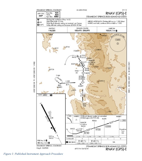
A review of archived Federal Aviation Administration (FAA) automatic dependent surveillance broadcast (ADS-B) data revealed that the airplane departed Cody, Wyoming, about 1705 for the estimated one-hour flight to Steamboat Springs/Bob Adams Field (SBS). FAA air traffic control (ATC) data showed that the pilot was operating on an instrument flight rules flight plan and was cleared by ATC to conduct the RNAV (GPS)-E instrument approach procedure at SBS about 1757.
For terrain clearance, the procedure required the airplane to cross the final approach fix PEXSA at or above 9,700 ft mean sea level (MSL) and WAKOR, the next waypoint located 2.2 nm from runway 32 threshold, at or above 8,740ft MSL. The ADS-B data showed that the accident airplane crossed PEXSA about 9,100 ft MSL and WAKOR about 8,200 ft MSL respectively.
The procedure allowed for a descent to the minimum descent altitude of 8,140 ft MSL or 1,258 ft above ground level (AGL) after passing WAKOR. The missed approach point for the procedure was the runway 32 approach end and required a climbing left turn to 11,300 ft MSL and proceeding direct to the HABRO waypoint to enter a holding pattern.
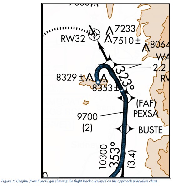
Immediately after passing WAKOR, the airplane made a left turn as shown in figure 2 and descended to an altitude of about 7,850 ft MSL. The airplane subsequently began to climb and the last ADS-B data point recorded at 1808:49 indicated an altitude of about 8,125 ft MSL and was located about 3.5 miles north of the accident site.
The airplane first impacted Emerald Mountain about 8,172 ft MSL on a heading of about 164° as evidenced by broken and cut tree branches. After the initial impact, the airplane bounced and came to rest about 8,216 ft MSL, and sustained substantial damage to the fuselage, tail, and both wings.
The METAR at the time of the accident indicated a cloud ceiling of 1,200 ft above ground level (AGL) and 1sm visibility. The instrument approach procedure for a category A aircraft required 1 ¼ sm flight visibility for landing and 1 ½ sm for category B aircraft.
A detailed wreckage examination is pending.
Aircraft and Owner/Operator Information
Aircraft Make: Piper
Registration: N744Z
Model/Series: PA46-500TP
Aircraft Category: Airplane
Amateur Built:
Operator:
Operating Certificate(s) Held: None
Operator Designator Code:
Meteorological Information and Flight Plan
Conditions at Accident Site: IMC
Condition of Light: Night
Observation Facility, Elevation: KSBS,6879 ft msl
Observation Time: 17:55 Local
Distance from Accident Site: 7 Nautical Miles
Temperature/Dew Point: -9°C /-9°C
Lowest Cloud Condition:
Wind Speed/Gusts, Direction: 5 knots / , 260°
Lowest Ceiling: Overcast / 1200 ft AGL
Visibility: 1 miles
Altimeter Setting: 29.95 inches Hg
Type of Flight Plan Filed: IFR
Departure Point: Cody, WY
Destination: Steamboat Springs, CO
Wreckage and Impact Information
Crew Injuries: 1 Fatal
Aircraft Damage: Substantial
Passenger Injuries:
Aircraft Fire: None
Ground Injuries:
Aircraft Explosion: None
Total Injuries: 1 Fatal
Latitude, Longitude: 40.459893,-106.85728
Dr. Clinton Devin
~A 46-year-old Steamboat Springs man died Friday evening after his plane crashed at the top of Emerald Mountain, according to officials.
Dr. Clint Devin, an orthopedic surgeon with Steamboat Orthopedic and Spine Institute, was the pilot and sole occupant of a small aircraft. On approach to Steamboat Springs Airport, Denver Air Center lost contact with Devin at around 6 p.m., Routt County Undersheriff Doug Scherar said Saturday morning.
The air center contacted the Routt County Sheriff’s Office, which was able to track the plane to the area of Emerald Mountain, west of downtown Steamboat. Routt County Search and Rescue volunteers used snowmobiles to access the top of Emerald and located the plane. Devin was pronounced dead at the scene.
Devin’s family has been notified, according to Routt County Coroner Rob Ryg. He is survived by his wife, Jessica Devin, an endocrinologist who practices in Steamboat, and their two sons.
Dr. Jon Hamilton, a primary care physician at UC Health Yampa Valley Medical Center, said in his three years of friendship with Devin, the two shared memories of flying together, talking about aircrafts and helping each other’s patients through medical issues.
“I trust him enough to take care of my family; he’s very good at what he did and very good with people,” Hamilton said. “He’s definitely a true loss to the community.”
Hamilton described Devin as both an excellent physician and a kind man who made patients feel at ease.
“(Devin) had a very personable nature that served him well and served his patients well,” Hamilton said.
Devin took care of Hamilton’s son through several medical procedures, which Hamilton said strengthened the relationship between his and Devin’s family.
“I did call him with concern for a very dear patient of mine on a Saturday,” Hamilton said. “He took care of them on a Saturday, when he didn’t have to, and that just speaks to his nature and how he was.”
Before joining SOSI, Devin was the head of spine trauma at Vanderbilt University in Nashville, and an adjunct associate professor of orthopedic surgery and neurosurgery at Vanderbilt University Medical Center. He grew up in Laramie, Wyoming.
The National Transportation Safety Board will be investigating the crash in the next several weeks, Scherar said.
Backcountry access on Emerald is closed until further notice, but normal downhill operations at Howelsen Hill Ski Area are open, Steamboat Springs Parks and Recreation Director Angela Cosby said.


Flightaware:
ReplyDeletehttps://flightaware.com/live/flight/N744Z
Adsbexchange missed the last bit:
https://globe.adsbexchange.com/?icao=aa03a5
6:12 PM MST = 18:12, +7 UTC offset = 01:12 Z UTC Day 11
DeleteMETARS:
KSBS 110115Z AUTO 24009KT 1SM OVC014 M09/M09 A2996
KSBS 110055Z AUTO 26005KT 1SM OVC012 M09/M09 A2995
N744Z registered 06/24/2021 to this owner.
DeleteN744Z was a Treasury Auction aircraft, seized 2011. Interesting to note that Aviationdb.com query shows the aircraft has had 8 different owners since sold at seizure auction. Equipment listing and photos, are noted below:
Garmin GMA 340
(2) Garmin GTX 327
(2)Garmin GNS 530
S-Tec Auto-Pilot
Honeywell KMH 820
King KMD 540
Honeywell KA815
Stormscope NY-163 Antenna
King KRA-10A
BFG Attitude Gyro
(More equipment details in Aircraft.com misting, below)
Panel photos from auction listing (jpegs updated March 2015):
https://www.yachtauctions.com/images/photos-air/22/22__12.jpg
https://www.yachtauctions.com/images/photos-air/22/22__8.jpg
Panel photos from Aircraft.com (2015 or 2016 listing date):
https://media.sandhills.com/n744z-2002-piper-meridian/img.axd?id=3003472561&wid=6072144879&rwl=False&p=&ext=&w=614&h=460&t=&lp=&c=True&wt=False&sz=Max&rt=0&checksum=5hdBMwQl5ykgn2U45SN2pEkpR7yV18mb5fEL317YLWs%3d
https://media.sandhills.com/n744z-2002-piper-meridian/img.axd?id=3003472563&wid=6072144879&rwl=False&p=&ext=&w=614&h=460&t=&lp=&c=True&wt=False&sz=Max&rt=0&checksum=5hdBMwQl5ymzXbHYKwqeVBpIsGo%2fugUGiatDPAo8bvg%3d
https://media.sandhills.com/n744z-2002-piper-meridian/img.axd?id=3003472565&wid=6072144879&rwl=False&p=&ext=&w=614&h=460&t=&lp=&c=True&wt=False&sz=Max&rt=0&checksum=5hdBMwQl5ylY%2fOM8VUaBlw9SQaLEes%2bIUIfJ7EJSXPM%3d
Panel photo from Mead listing:
https://www.meadaircraftsales.com/copy-of-n411md-photos?pgid=km25wvrp-25170963-2f5d-4d4f-a91a-6da9206a59d5
Sources:
Seizure sale listing:
https://www.aircraftauctions.com/aircraft-inventory/22/
Aircraft.com listing (2015 or 2016):
https://www.aircraft.com/aircraft/1434079/n744z-2002-piper-meridian
Mead Aircraft listing (says n411md, but shows N411Z):
https://www.meadaircraftsales.com/copy-of-n411md-photos
https://www.aviationweather.gov/metar/data?ids=KSBS&format=decoded&hours=96&taf=off&layout=on
Deletedecoded Text: KSBS 110055Z AUTO 26005KT 1SM OVC012 M09/M09 A2995 RMK AO1 T10921092
Temperature: -9.2°C ( 15°F)
Dewpoint: -9.2°C ( 15°F) [RH = 100%]
Pressure (altimeter): 29.95 inches Hg (1014.3 mb)
Winds: from the W (260 degrees) at 6 MPH (5 knots; 2.6 m/s)
Visibility: 1.00 sm ( 1.61 km)
Ceiling: 1200 feet AGL
Clouds: overcast cloud deck at 1200 feet AGL
QC Flag: automated observation with no human augmentation
It appears the pilot was shooting the RNAV GPS-E. The track log in FlightAware has him go below the MDA then back up to 10 feet above the MDA with airspeed increasing rapidly possibly indicating a missed approach. However, the pilot initiated the climbing turn at the WAKOR fix instead of the MAP (RWY32 TH) striking terrain off the W end of the final approach segment. The approach was below the required flight visibility and the ceiling was only about 100 feet above the minimum altitude according to the above METAR.
ReplyDeleteFor non pilots here is the info:
Deletehttps://flightaware.com/resources/airport/SBS/IAP/RNAV+(GPS)-E/pdf
Look at the WAKOR fix vs. RW32... if one does the arc to the west too early they will hit the mountain indicated by 8329.
A post further down the thread maps the turn sequence:
Deletehttp://www.kathrynsreport.com/2021/12/piper-pa-46-500tp-n744z-fatal-accident.html?showComment=1639333331295#c2760605775633976846
I wouldn't put too much stock in the altitude reported by FlightAware being accurate beyond +/- several hundred feet.
DeleteDon't forget that the altitude reported by ADS-B sources via FlightAware is typically height above ellipsoid, which can vary by several hundred feet or more from the (barometric-derived) indicated altitude that is controlling for instrument approaches. flightaware.com/about/faq/#AGLorMSL
Can you please expand on this more. Dr. Devin was one of my mentors and I'm looking for closure. I'm not a pilot.
ReplyDeleteI'm trying to decipher what you mean. Are you saying he was doing an instrument-only approach, got too low, and then accelerated upwards, which might mean he missed his approach, but since he turned at the wrong landmark (Wakor?) instead of MAP, that means maybe he started his approach at the wrong time? Thought he was supposed to be turning when he shouldn't have? Or turned too late? I see some places talking about how Steamboat is a tough cirle-to-land runway.
Does your comment about the visibility imply poor visibility and weather shouldn't have been an issue.
Do you think it was mechanical failure? Pilot error?
Thank you.
He basically botched the missed approach and deviated which is lethal in mountainous terrain. Pilot error.
DeleteProper approach self-briefing (if flying solo) is critical to properly understand the approach.
Generally it will consist of checking and calling out loud the correct heading, the final approach fix altitude, how low can one go, and the FIRST TWO THINGS to do on a missed approach.
There are specific rules to go missed. Too low ceiling and failure to see the airport environment upon reaching a specific point and also if not properly following the procedure and deviating from it by too much.
Instrument proficiency is a perishable skill and if not practiced enough degrades.
I am sorry for your loss. Dr. Devin had accomplished a lot in life. The facts will slowly come out of the NTSB, but as I read this story he was flying a standard instrument approach (in the clouds) alone in the mountains after dark. His aircraft was well suited for it but any mistake can become tragic. Flying is normally safe, but in the mountains, at night, in IMC and single-pilot operations removes many of the guardrails of that safety.
Deletehttps://skyvector.com/files/tpp/2112/pdf/06404RE.PDF
DeleteHere is the approach. The solid line depicted is the approach flight path and the missed approach is depicted as the dotted line. WAKOR is 2.2 nautical miles south east of the actual missed approach point. You can see a mountain between WAKOR and HABRO which is what he turned into.
Weather reported was below what is allowed for the approach. The small deviation below flight path might have been an accident which he corrected, or was intentional to try and "dip" below the clouds to look for the airport. We will never know that.
The turn at the wrong checkpoint was undeniably pilot error.
It would be an understandable mistake if the pilot was new to this airport and approach BUT this was his home airport although it appears he bought the accident aircraft in early 2021 so avionics unfamiliarity might be an issue.
DeleteEven with new avionics, if he was approaching below MDA, shouldn't he have corrected that before starting the missed approach turn? Aren't you supposed to fly over the runway before initiating the return, and isn't the location of the runway pretty easily recognized? I don't get why he would go from just below MDA to immediately ripping the turn.
Deletedecoded Text: KSBS 110055Z AUTO 26005KT 1SM OVC012 M09/M09 A2995 RMK AO1 T10921092
DeleteTemperature: -9.2°C ( 15°F)
Dewpoint: -9.2°C ( 15°F) [RH = 100%]
Pressure (altimeter): 29.95 inches Hg (1014.3 mb)
Winds: from the W (260 degrees) at 6 MPH (5 knots; 2.6 m/s)
Visibility: 1.00 sm ( 1.61 km)
Ceiling: 1200 feet AGL
Clouds: overcast cloud deck at 1200 feet AGL
QC Flag: automated observation with no human augmentation
Yes, MAP needs to be flown at runway in this instance. If avionics aren’t set up correctly, maybe something mis-sequenced…then a distraction, followed by decision to go missed, but with the distraction comes loss of SA, start missed turn forgetting about the mountains. How could he forget about the mountains? Go teach professional pilots in simulators and you’ll see these types of mistakes on the regular. Pilots are human and we make mistakes all the time.
DeleteUnlike a precision approach, on a non-precision approach, he didn't need to go missed upon reaching the MDA. He could have leveled off at the MDA until reaching the RY32 missed approach point, but for some reason he decided to go missed early and made the fatal mistake of not continuing direct to the MAP before executing the lateral portion of the missed approach procedure.
DeleteAlso important to note that the altitudes reported by FlightAware are not super accurate and are probably a couple hundred feet off from the indicated altitude the pilot was seeing, so he may not have gone below the MDA at any point.
He was going around, and turned too early, and hit a mountain. In the heat of battle, it is an easy mistake to make. I'm sorry for your loss.
DeleteHow is the MAP identified? I see it's at the threshold. What is the radio aid to determine you have reached it?
DeleteThe pilot was almost definitely on the RNAV (GPS)-E approach, which, as the name suggests, requires an IFR-certified GPS. The RW32 missed approach point can only be GPS identified and cannot be identified through a radio aid.
DeleteThe other approach to KSBS is the VOR/DME-C approach. For that approach, the missed approach point is identified when you are 2.9 NM DME on the 352 radial from the Robert (BQZ) VOR.
May Dr. Devin rest in peace. He was doing one of the things he loved (flying), but apparently made a critical error in a situation where a critical error can be (and in this case was) fatal. The NTSB will make the official finding, but the already-known facts are pretty decisive. What a shame to lose a brilliant ortho surgeon in this manner.
ReplyDeleteWhat is most sad is given dark/night, low weather, and mountainous terrain, Hayden (HDN) was only 16 miles west with an ILS. Under those conditions Hayden was 100% safer. There is a reason the airlines (Skywest) go into HDN and not SBS. Had he landed at HDN he would have only needed to call the wife for a ride or taken an Uber. I see this ALL the time….pilots making bad decisions based off perceived pressure about where and hen they need to land. Landing at HDN and then moving the plane back to SBS a day or two later probably sounded like a pain at the time while descending into SBS.
ReplyDeleteFor the individual above wanting to know if this was pilot error, for those of us that live and breath this stuff, this has pilot error written all over it. The biggest error is frankly starting the approach in the first place. Single pilot, night, mountains, and low weather. That is challenging even for a professional pilot. There may have been extenuating circumstances…new to airplane and unfamiliar with avionics? Got distracted at a bad time? Got disoriented for some reason?
Me personally? 9,000 plus hours, prior military aviator, aircraft owner for 17yrs, and airline pilot for last 8 years and there is no way I’d have attempted that approach under those conditions. I’d have gone to HDN.
for this layperson, under what IMC would an airport or ATC close for arrivals and departure? Declare do not attempt to land, below MDA or whatever!
ReplyDeleteFor private aircraft, as this was, arrivals and departures are usually at the pilot's discretion. Commercial operators have much stricter guidelines. The approach chart has a minimum visibility which depends on many factors. Commercial operators can not start an approach if the visibility is not above the charted minimum but private operators have no restriction. However an approach performed when visibility is below the charted minimum will likely result in the pilot not seeing the runway and having to perform the missed approach procedure which is what appears to have happened here.
DeleteYou can see how the turn tracked on the terrain by clicking through mapped ADS-B positions in sequence.
ReplyDeleteLoad the map links below of the last six recorded points from FA track log in separate windows and observe the map pins as you click through the windows.
Data point 40.4672 -106.8349 ↖ 323° 8,350:
https://www.google.com/maps/place/40%C2%B028'01.9%22N+106%C2%B050'05.6%22W/@40.4772551,-106.8514117,9292m/data=!3m1!1e3!4m5!3m4!1s0x0:0x988f052dc9eba352!8m2!3d40.4672!4d-106.8349
Data point 40.4756 -106.8417 ↖ 329° 8,250:
https://www.google.com/maps/place/40%C2%B028'32.2%22N+106%C2%B050'30.1%22W/@40.4773465,-106.8514203,9292m/data=!3m1!1e3!4m5!3m4!1s0x0:0x1efe80e22078e926!8m2!3d40.4756!4d-106.8417
Data point 40.4779 -106.8510 ← 261° 7,900:
https://www.google.com/maps/place/40%C2%B028'40.4%22N+106%C2%B051'03.6%22W/@40.4775083,-106.8511502,9292m/data=!3m1!1e3!4m5!3m4!1s0x0:0x51b5923fdc311181!8m2!3d40.4779!4d-106.851
Data point 40.4720 -106.8589 ↙ 201° 8,000:
https://www.google.com/maps/place/40%C2%B028'19.2%22N+106%C2%B051'32.0%22W/@40.4776068,-106.8518726,9292m/data=!3m1!1e3!4m5!3m4!1s0x0:0x84ecb8bff112a53d!8m2!3d40.472!4d-106.8589
Data point 40.4609 -106.8578 ↓ 162° 8,150:
https://www.google.com/maps/place/40%C2%B027'39.2%22N+106%C2%B051'28.1%22W/@40.4778116,-106.8517489,9292m/data=!3m1!1e3!4m5!3m4!1s0x0:0xdc30620c2433eeb0!8m2!3d40.4609!4d-106.8578
Data point 40.3500 -106.9846 → 90° (ADS position seems erroneous):
https://www.google.com/maps/place/40%C2%B021'00.0%22N+106%C2%B059'04.6%22W/@40.4537777,-106.8676235,37183m/data=!3m1!1e3!4m5!3m4!1s0x0:0xe6e6cda0f5348246!8m2!3d40.35!4d-106.9846
For reference, an elevation 8200' ridge line on Emerald mountain (AKA Quarry Mtn) at that fifth data point is found in topo map grid squares 24 and 19 of the map linked below.
https://www.topozone.com/colorado/routt-co/city/steamboat-springs/
In general, ATC doesn’t deny approach requests for weather. At controlled airports ATC may shut down an approach if there is a thunderstorm right over the approach corridor or wind shear reported on the ground.
ReplyDeleteBut at an uncontrolled airport like SBS, unless the runway is closed snow removal, for example, ATC is not going to deny an approach request. Generally speaking, there is nothing wrong with you tempting the approach. At the missed approach point, if you see the runway, you land, and if you don’t, you go missed. It is up to the pilot determine whether he should even be attempting the approach in the first place, not the controller.
And BTW, there in lies another challenge with an uncontrolled airport like SBS. No Approach Controller and no Tower controller. And approach controller will monitor the approach via radar and could’ve warned the pilot that he was turning early towards the mountains and rising terrain. A tower controller can provide real time weather updates to the pilot during the actual approach. In other words, you have a lot of help from ATC but only at certain airports. SBS is not one of those airports. The center controller only cleared the pilot for the approach, but he’s got too much going on as a Center controller to be monitoring the approach.
That is simply another accepted risk of flying into uncontrolled airports. Doing it at night, in the weather, and mountains, and single pilot, is stacking the cards against you.
This plane had an incredibly capable panel upgrade in 2015 as noted in the Aircraft.com advert from 2015. The current panel might even be more capable. The ad notes that the plane had dual Garmin 500's and dual 750's with Synthetic Vision. The Garmin's will of course have terrain mapping built in with warnings and alarms. The ad also said it had a separate Ground Proximity Warning System as well as separate Traffic and Terrain. This should provide the pilot multiple forms of situational analysis under any condition (if everything is working).
ReplyDeleteHe had flown into Steamboat Springs 26 times in the last 90 days per FlightAware.
Prior to owning the Meridian he owned a similar but piston powered Malibu Matrix, N6105E, which he flew in and out of Steamboat. The 500 shaft HP turboprop allows the Meridian to climb at over 1,700 fpm - he was flying single and lightly loaded so even at 7,000 ft elevation the Piper should quickly climb to safe altitude.
https://www.aircraft.com/aircraft/1402881/n744z-2002-piper-meridian
It doesn't make sense - he would have avoided the turn into Emerald Mountain and would have climbed sufficiently unless something else was wrong. For those that say that it is "undeniably pilot error" and "obvious", they are just prematurely speculating. The NTSB will review the wreckage for failures, retrieve all non-volatile data from the numerous devices/sources, review equipment settings and commands and pilot communication as well as the ADSB data from which everyone is drawing conclusions. The family and public will know more in about a year.
Ii is so sad that it will take a year to find the conclusions of the investigation.
DeleteTwo points offered upthread that were not speculation that should be considered relevant to this accident without waiting a year:
Delete1. No ILS exists at SBS. HDN has ILS, just 16 miles away.
2. SBS is non-towered, so no SBS ATC was available/interacting.
Instead of saying "No ILS exists at SBS", we might say be "no precision approaches exist at SBS." HDN has several RNAV LPV approaches that I'd prefer over an ILS. In my experience, ILS signals can be prone to fluctuation due to ground interference whereas LPVs are almost always rock solid.
DeleteOf course, we could go even further and say "No non-circling approaches exist at SBS" and the why is of course terrain. The terrain surrounding HDN is far more forgiving. HDN also has MALSF approaching lighting into runway 10.
For point 2, HDN is also non-towered. The closest towered airport is Eagle County Regional 50 miles to the south, but it also has only circling approaches and even more challenging terrain.
The official report will take about 2 years.
DeleteBut -- barring unusual findings -- this is almost certainly due to a failure of the pilot to follow the published approach procedure, which is a TECHNICAL PILOT ERROR.
Perhaps even more of a factor is NON-TECHNICAL PILOT ERROR in that he never should have made the DECISION to approach this airport under these conditions. Flawed decision-making which put him in a situation for which the odds of a good outcome were lower that what most of us would judge to be "acceptable risk".
The saddest part about this? Dr. Devin was likely unaware of just how unsafe his behavior was.
Do any of those previous 26 arrivals of 744Z appear to show the missed approach flown correctly? Emerald Mountain is one of a handful of the most prominent high elevation features in the Steamboat area of the Yampa valley. It looms large over town and is well known to anyone who's spent more than a few hours there. Even considering task saturation amid the conditions, it's hard to understand the loss of situational awareness that appears to have occurred here. He lived there, SBS was his home airport and he flew in and out of there regularly. It's horribly sad.
DeleteI agree, usually I am somebody to straightforward assign pilot error when appropriate, but here he may have had a panel failure, electrical failure, medical event, or something else - he has done this as home airport likely many times.
DeleteUnlike that Dr. Das crash in KMYF who seemed like an idiot on previous flights, this guy seemed extremely competent all around.
Flight tracks show he descended below MDA, and made what appeared to be a turn too early on what is suspected as a missed approach procedure. But why did he or the airplane do this? Was there a “medical” event such as a strike or heart issue? Was there an instrument malfunction? Was there a mechanical malfunction? No one will know or understand why he continued into SBS, with much better approach and ATC capabilities at HDN a few miles away. I believe that all who are now pre-judging this fine man and as to the causes, need to take a step back and let the accident investigation run it’s course. I survived flying for portions of four decades all over North America. I look at this and can say that sometimes in my flying past “there but with the grace of God go I”. I pray for him, his family, and all of those whose lives he has made better with his skills.
ReplyDeleteOkay, so this one seemed fairly easy to piece together, so made a few slides to make it easier to see the trajectory of this plane on approach as well as what should have been done to go missed on the approach issued to the pilot:
ReplyDeletehttps://www.dropbox.com/s/9avul88miii01r6/accident%20report%20on%20n777z%20%28traveling%20from%20KCOD%20to%20KSBS%29.pdf?dl=0
The pilot was issued a clearance for KSBS from KCOD via the route KCOD --> CHE --> KSBS (see slide 1). Upon coming into steamboat springs, the pilot was given the RNAV (GPS)-E approach and given instructions to go direct to the HABRO IAF (see left panel on slide 1 of the above linked pdf). The left panel on slide 1 shows both the approach plate and course of the plane flying this approach (from flightaware). It all lines up perfectly on what the pilot was supposed to be doing in flying the approach. Slide 2 of the linked pdf shows the foreflight version of slide 1.
According to flightware, the pilot crosses the FAF PEXSA at 9500ft, roughly 200ft lower than is expected (indicated in the plate). See slide 3 for a clear view of the approach path overlayed with the plate. This could be ads-b is not fully accurate. Let’s assume the altitude is off by 200ft. The pilot is clear to descend to 8740ft from PEXSA to WAKOR (slide 3). At WAKOR flightware indicates the plane is at 8400ft, so assume 200ft in error, so 8600ft which is close to 8740ft indicated in the plate (so seems about right).
The pilot begins turning just after WAKOR, while at about 8300ft as indicated by flightaware, so applying the 200ft correction would be closer to 8500ft, 390ft above minimums if the local altimeter setting was acquired. In the turn the pilot keeps descending, down to 7900ft at the lowest point indicated. It’s unclear why the pilot would decide to go missed well above minimums and then begin turning two miles before the missed approach point, where the turn should have been initiated (see again slides 3 and 4 in the attached). On a missed approach one should be full power, raising flaps, and climbing aggressively and turning as indicated. The pilot did appear to go full power after initiating the turn, but kept descending instead of climbing aggressively. In addition, the pilot clearly turned 2 miles too soon and turned direct to HABRO as he should have, but in turning so early, that flew him right into the mountain.
Seems perhaps that the pilot did not have a terrain awareness system either? As in my plane with such a system the voice and alerts would have been screaming at me to climb. I would have been given a visual as well on that map that I was too low. And it must be as well that ATC did not issue him a warning on turning too soon or being too low, although at that point things would have happened fast.
My read of this is that the pilot did not fly the approach correctly, did not fly the missed procedure correctly, did not have the most current systems to warn on the terrain, and the controller perhaps not able to issue an alert to the pilot. So very sad. This appears to have been 100% avoidable. A good learning for us all on flying circle to land procedures and missed approaches when conditions are poor.
Lets say he DID have the most current system (new plane in 2021). Would that mean he was ignoring the warnings? Or could something have happened where the system gave the wrong information and told him he was past the missed approach point?
DeleteThe assumption in that wall of text that altitude is 200 feet higher than the reported ADS-B barometric altitude is WRONG.
DeleteADS-B barometric altitude is referenced to 29.92 and local altimeter at the time was 29.96 according to the SBS METAR. The offset difference is negligible.
To anonymous comment at 12/12/21 11:14PM EST, your assumption about FlightAware data is ALSO WRONG. Per the track log, ALL of the accident flight's data on FlightAware was obtained from ADS-B. Read the FlightAware FAQ at flightaware.com/about/faq/#AGLorMSL : "ADS-B data is frequently height above ellipsoid" NOT barometric altitude. Height above ellipsoid is NOT the same as absolute height above sea level, in fact for most of the US, the ellipsoid plane can be over 100 feet LOWER than sea level. Furthermore, when the temperature aloft is lower than standard like it was during this accident, the indicated barometric altitude aloft can be even lower than the actual altitude, even when corrected by a local altimeter setting. This is why we have cold temperature altitude corrections for approaches.
DeleteTo summarize, ADS-B data from FlightAware is nowhere near exact and was never intended for airchair accident investigators to make the sort of conclusions people are making about the pilot going below the MDA. Once we get official FAA radar or ADS-B data, we might be able to make more definitive conclusions.
To the 9:28pm anonymous question, if your taws system is telling you “pull up, pull up” and you are getting red flashing alerts on your primary flight display that you are on a crash course, that is not at all usual and not something you would easily ignore (imagine somebody in your screaming at you to "watch out".
DeleteThe pdf I link above lays out the path and demonstrates the pilot was well executing the rnav gps-e approach from the HABRO IAF. It’s reasonable to assume he would have been following the altitudes in the approach plate which would mean ads-b inferred altitude is slightly off (I see this *all* the time in my own flights where I know the exact approach course I flew).
Pilot decided to go missed for whatever reason and turned as he should have to go direct to HABRO but turned 2 miles too early and was not immediately climbing at full power, at least according to the ads-b data. Given everything in front of us right now it is the most likely scenario.
Notoriously unreliable ADS-B data now mimics Schrodinger's cat.
DeleteIt's invalid & valid with the proper adjustment, simultaneously!
Adjusting the admittedly inaccurate ADS-B data to support the notion that the pilot was hitting the proper alts all long before the turn requires that the ADS-B reported altitude through the turn be similarly adjusted.
The ADS-B data point corresponding to N744Z being at but not clearing Emerald/Quarry mountain's 8200' MSL ridge in the area of those coordinates included a transmitted altitude of 8,150'.
Continuing the notion that the 8,150 is correctable to true:
"Applying the 200ft correction" makes it 8,350' MSL.
The +200' "correction" disproves itself at the ridge line.
For reference:
Pinned map location, data point 40.4609 -106.8578 ↓ 162° 8,150:
https://www.google.com/maps/place/40%C2%B027'39.2%22N+106%C2%B051'28.1%22W/@40.4778116,-106.8517489,9292m/data=!3m1!1e3!4m5!3m4!1s0x0:0xdc30620c2433eeb0!8m2!3d40.4609!4d-106.8578
Yes, so perhaps too strong to say a correction can be applied. I suppose what was meant by that was that we can reasonably assume that the pilot was flying the approach at the indicated altitudes, so nothing wildly off. It is using a Bayesian approach where there is some assumption on prior probabilities (e.g., the pilot was likely largely flying the approach as published given other data supports this, such as hitting the different approach fixes at roughly the correct altitudes and precisely making required turns and changes in heading) to then weight posterior probabilities as to what likely caused the pilot to crash.
DeleteData are never perfect so we use different lines of evidence and informed prior distributions and so on to assess different interpretations of the data and then select the one with the highest posterior probability if it is "significantly" beyond the next best posterior probability. It's simply how our minds work and how we learn and then we adjust all of this as more data comes in.
P.S. There was a transmitted altitude of 7900ft as well so at the "corrected" altitude would have been 8100, and at this point could have been hitting trees and causing damage even despite some marginal climb and then went down. Hard to say what was happening at the end there. More data should be forthcoming on where exactly the crash happened and will likely shed light on altitude.
That location where 7900' was transmitted maps out at terrain with elevation 7200' just about dead center of grid square 20 on the topo map (see links below).
DeleteIn that 7900' data point example, it's incorrect to suggest "could have been hitting trees" at that point. Position coordinates of the data transmitted in the turn were already mapped on to the corresponding terrain in an earlier comment.
For reference:
Map-pinned data point 40.4779 -106.8510 ← 261° 7,900:
https://www.google.com/maps/place/40%C2%B028'40.4%22N+106%C2%B051'03.6%22W/@40.4775083,-106.8511502,9292m/data=!3m1!1e3!4m5!3m4!1s0x0:0x51b5923fdc311181!8m2!3d40.4779!4d-106.851
Interactive topo map:
https://www.topozone.com/colorado/routt-co/city/steamboat-springs/
Comment showing turn data coordinates mapped to terrain:
http://www.kathrynsreport.com/2021/12/piper-pa-46-500tp-n744z-fatal-accident.html?showComment=1639333331295#c2760605775633976846
This all seems quite pointless quibbling. Why does it matter if the pilot busted the MDA or not? He turned too early on the missed approach procedure and hit terrain. That was the ultimate cause of the accident. It was still a fatal mistake no matter how far above or below the MDA he was at earlier on the approach. (For the record, while on autopilot, I have FlightAware show my aircraft at 200 knots faster than Vne AND over 1,500 feet off my actual cruising altitude for a few minutes and then correct to reality, so I too do not put too much stock in what it shows. There is a good reason that it rounds altitude to the nearest 100 feet.)
DeleteThe commentator at Monday, December 13, 2021 at 1:55:00 PM EST is wrong again. Womp womp!
DeleteJust take a look at the FAA approach plate. It shows two obstacles, one at 8329 MSL and one at 8353 MSL right where the plane hit, so yes even at 8,350 MSL, the plane could still smack into something. Also, there are always significant downdrafts that close to the ridge, so those could have easily pushed him into down into terrain.
Amazing how people think they can determine precisely what happened from track points 20-30 seconds apart.
Did the aircraft hit that tower on top of the ridge, or terrain?
DeleteHow does the discussion/details on this crash compare to similar crashes? Does this smell 'strange' to you all, or is this how crashes happen?
ReplyDeleteNothing smells strange at all. He was a low time IFR rated pilot who for some reason didn't execute the proper missed approach. And we may never know why he did what he did if all the other things check out fine.
DeleteSadly, this is not unusual. While there is zero evidence right now about if this pilot was a low time or high time IFR rated pilot, what is clear is that humans make mistakes all the time, even highly trained ones. Take automobile drivers, you could ask licensed drivers what side of the road to drive on and if they should stop at red lights and stop signs and ever single one will give you the right answer. Yet, hundreds of fatalities occur every year due to drivers running red lights or stop signs or driving on the wrong side of the road. After such incidents, some drivers would swear they did nothing wrong until seeing evidence proving otherwise. It's just a fact of life that people are fallible and make mistakes especially during times of high workload and stress such as single pilot IFR in hard IMC.
DeleteDoes anyone suspect icing being it was only 15f and 100% humidity? He was slow enough and not climbing even when power was added.
ReplyDeleteI doubt it had a factor. If you were icing up and unable to climb or loosing altitude then you would keep wings level to keep all lift vertical. Turning like he did would have banked the wings and transferred some lift to horizontal which would cause you to descend even faster.
DeleteWell, that's an interesting question because I've been thinking on why he would choose to go missed early, with data available at this point indicating the pilot decided to go missed above minimums (given ads-b data and where the plane was on the final approach course).
DeletePilot would have been IMC (else why would you go missed) and maybe was seeing ice accumulating and perhaps decided to go missed and get clearance to an alternative airport with higher precision approach capabilities, clear ice from wings, etc. I agree with the above that the icing would not have caused the crash directly.
Any GPS navigation system certified for IFR flight would not sequence to the next waypoint on the missed approach before the pilot passed the specified missed approach point. The pilot turning to that waypoint was almost definitely something he did on his own, not something his navigation system directed him to do, unless he overrode it.
ReplyDeleteAgreed. In fact given it would have been dark, IMC I would definitely have autopilot engaged to fly down to minimums and if going missed would have disengaged autopilot to go full power, eliminate flaps and climb and turn, but would have definitely been following the flight director!
DeletePerhaps this will become a textbook example on the difference between getting to MDA and decided to go missed, and hitting the missed approach point and flying the missed procedure starting there as opposed to one you decided to go missed at MDA. I don't think I appreciated how precisely the missed approach course would need to be followed between hitting MDA and flying the missed approach. Even in the summary of the missed approach course to fly on this approach plate, it doesn't reinforce to be sure you wait until hitting the missed approach point before climbing and turning but rather just states to execute a climbing turn to HABRO and climb to 11,300ft. Given the degree to which it matters in this approach where you start turning between the final waypoint (WAKOR) and the missed approach point (i.e., turn to soon and you will hit a mountain), it would be a nice feature for the "missed approach" box in the plate to specifically call ed this.
I could see deciding to go missed in IMC and maybe accumulating some ice and at night, looking at the missed approach box and seeing the instructions to execute a "climbing left turn direct to HABRO" and not thinking I was not yet exactly at the missed approach point.
Circling (versus "straight-in") approaches are very challenging because the conditions under which they are flown are marginal: low clouds, low visibility, low speed, need for precise low-altitude maneuvering.
ReplyDeletePerhaps the pilot was conditioned to simultaneously initiate all aspects of the missed approach (climb AMD turn) because that's what is typically done in training on straight-in approaches? Or maybe he THOUGHT he saw the airport underneath him (roads, etc) and was maneuvering for what he believed to be the runway?
He needed to CLIMB STRAIGHT AHEAD to the missed approach point over the airport before turning. He would have been fine had he done so.
We can all learn from this.
However: even attempting this night, low clouds, low visibility mountainous approach is risky, even for a 2-crew professional operation, let alone a low-time amateur single pilot.
a consideration is onset spatial disorientation during his ifr approach in imc, just takes one distraction, one look away and return..
ReplyDeleteThe official report will take about 2 years.
ReplyDeleteBut -- barring unusual findings -- this is almost certainly due to a failure of the pilot to follow the published approach procedure, which is a TECHNICAL PILOT ERROR.
Perhaps even more of a factor is NON-TECHNICAL PILOT ERROR in that he never should have made the DECISION to approach this airport in the first place, under these conditions. Flawed decision-making which put him into a situation in which the odds of a good outcome were lower than what most of us would judge to be "acceptable risk".
The saddest part about this? Dr. Devin was likely unaware of just how unsafe his behavior was.
KSBS flightaware record for Friday, 10 Dec,lists one single arrival (which we know did not arrive) "Arrivals: Steamboat Sprgs Airport (Steamboat Springs, CO) [KSBS] N744Z P46T Yellowstone Rgnl (KCOD) Fri 17:04 MST Fri 18:12 MST.
ReplyDeleteNo SBS arrives the day prior, and no arrivals or departures Thursday or Friday. Earliest arrival was a local flight Sat 13:19 MST.
Lone wolf tempted the impossible!
I am a commercial rated pilot with 1800 hours in type in TBM9 (a single engine turbine with more power and capability than the accident plane). I have flown into most airports in the rockies including SBS. Aspen has a 6.5 degree decent angle and is considered one of the most difficult mountain airports to land. SBS has a 7.75 degree decent. Flying the visual is challenging. You have to carefully review the approach chart to understand that by the time you reach the MDA (lowest legal altitude you can descend until the airport environment is visualized) you are less than a mile from the threshold and still 1,258 feet AGL landing on a 4,452 foot runway (landing "long" is not an good option). Maintaining a stabilized approach and safe landing is difficult for the most skilled pilots. Based on the METARs at the time both the visibility and the ceilings were outside the envelope of the approach. These are the facts of this approach and this airport at that time. I know a fellow TBM pilot that is based at SBS and he nor his other local Pilot buddies would have ever attempted this approach illustrating what was said earlier about DECISION making. My personal thought is that he got distracted and was stressed and hit the TOGA button which immediately vectored the plane to HABRO (the MA Hold) without realizing that there was a mountain in between him and HABRO. The published miss is at the RWY threshold. That's when you turn direct HABRO, Climb, Gear Up, Flaps up etc.(you can actually start your climb prior to that but you can't turn). All he had to do was wait less than a minute to reach that point and he would likely be alive today. Sad. My heart is heavy for his wife and children. May Dr. Devin RIP and may the rest of us pilots use this as another lesson to continue to make the best decisions and make sure we study all approaches and brief them appropriately.
ReplyDeleteWonderful insight and nice to know from one who knows this airport. That is a pretty massive descent angle. On my Cirrus SR22T/G6 the AP after you hit the go around button will sequence to the MAP; the flight director will not indicate a turn until you are at the MAP.
DeleteRelying on a coupled go around performed by a system that doesn't include automated avoidance of terrain is exactly the kind of automation hazard warned about in the 1997 children of the magenta line video.
Deletehttps://youtu.be/V5_GENu6aqg
I don't think this approach is even remotely designed for a straight-in descent. A 7.75 degree descent is UNSTABLE. It's called a CIRCLING approach for a reason.
DeleteThis comment has been removed by the author.
Delete...most pilots land straight in because most of the time they acquire the runway way before minimums because weather is usually above minimums.
DeleteDescending to land from MDA would require a 1,200 fpm descent at 90 knots while fully configured: that is not a stabilized approach.
Excellent insight from PDN and I agree with everything except saying the plane would vector him to HABRO when he hit the TOGA button. Every modern FMS I have ever used would vector you first to the missed approach point upon TOGA and only upon passing it would it vector you to the next missed approach fix (HABRO). I believe that behavior is a requirement in the FAA certification guidelines. In this accident, either the pilot manually flew direct HABRO or he overrode the FMS and selected direct HABRO before crossing the MAP.
DeleteI fly a TBM, and suggesting that approach can be flown straight-in is reckless. If you comply with the required altitude at Wakor, you have to descend nearly 1900' to the runway at a 7.75 degree descent angle. At 90 kts. groundspeed (which is about as slow as you can fly it unless you have a big headwind), you need to descend at >1200'/min. to get from Wakor to the runway threshold. By definition, that's unstable in the TBM, and probably most planes.
ReplyDeleteMost, if not all, US airlines prohibit circling approaches at night, so I can understand why you wouldn't want to circle. But that doesn't mean you go straight in. It means you go somewhere else.
I retired 20 years ago from a 40 MATS-PanAm-Delta career. I agree. Back in the day of ADF and fan marker approaches we would nake circling approaches in these conditions and terrain, but often that was the only alternative.
DeleteWhile somewhat unlikely, another possibility is that the pilot experienced a GPS outage while on the approach. This would require the pilot to immediately execute a missed approach, while also meaning he couldn't rely on GPS to fly that (GPS only) missed approach procedure. With no reliable GPS guidance, he might have tried to wing it after a quick glance at the missed approach procedure and did his initial turn way too early.
ReplyDeleteGPS outages happen more often than you think, especially with the ridiculous amount of military GPS jamming drills that happen on a regular basis. Not only should you ALWAYS brief your missed approach procedure, you should also consider what you would do in the case of a GPS outage during the approach, including what non-GPS navaids you could use and/or reviewing what your FMS's dead reckoning capabilities are in such scenarios.
https://notams.aim.faa.gov/notamSearch/nsapp.html#/results
DeleteNo NOTAMs found. Searched at: 2021-12-17 00:46:01 UTC
Location search on location(s) KSBS. 0 NOTAM(s) found.
You can experience a GPS outage for many reasons other than those covered by a NOTAM. The lack of a NOTAM does not prove the pilot didn't experience a GPS outage, downgrade, or related failure.
DeleteBut if you are going to search for GPS NOTAMS, it helps to know how to do it. You aren't going to find a GPS outage NOTAM by searching by a minor airport identifier. Use a little sense, they would have to index that NOTAM to thousands of airport identifiers in the outage area. You need to search by the center name, which would be ZDV for KSBS. You also have to explicitly search a past date range, or it will only return active NOTAMS. Here is one, although it is a little outside the accident location, as well as the accident time of day: https://www.faasafety.gov/files/notices/2021/Dec/WSMRNM_21-55_GPS_Flight_Advisory.pdf
NOTAM INFO: NAV GPS (WSMRNM GPS 21-55) (INCLUDING WAAS, GBAS, AND
ADS-B) MAY NOT BE AVBL WI A 405NM RADIUS CENTERED AT
334000SN1063600W (TCS043041) FL400-UNL,
353NM RADIUS AT FL250,
278NM RADIUS AT 10000FT,
289NM RADIUS AT 4000FT AGL,
238NM RADIUS AT 50FT AGL.
That's good info on proper look-up on interfering signals, but keep in mind that line of sight implications in mountainous terrain has to be understood to interpret that published radius/elevation data.
DeleteIf an aircraft in mountain terrain is already successfully going down an RNAV glide slope using GPS signals from satellites high above, getting below surrounding terrain blocks line of sight signals transmitted from terrestrial emitter sites.
For that example notice, if the accident time period had been within 0700Z – 1400Z of the notice, no disruption could be experienced from a New Mexico emitter site after N744Z was below the interposing terrain.
Again, scheduled military disruption of GPS signals are just one of many reasons you could experience degraded GPS signals. That same mountainous terrain can also block reception from satellites that are closer to the horizon.
DeleteGPS signals are extremely weak and there are many things that can interfere with them. For example, the FAA has a bulletin about SPOT trackers interfering with aircraft GPS systems and causing outages. https://www.faa.gov/other_visit/aviation_industry/airline_operators/airline_safety/info/all_infos/media/2019/InFO19006.pdf
I've experienced a WAAS GPS loss of integrity in flight that indicated my altitude was 1,500 higher than reality for several minutes. I was nowhere near any NOTAMed GPS test nor did I have any GPS trackers onboard. The cause was completely unknown, but had I been on a GPS approach, I would have had to immediately go around.
Finally, while this is definitely not related to the cause of this accident, if you want to truly be frightened by the fragility of the GPS network (and why the military constantly tests operational GPS outages), read this white paper: https://www.c4reports.org/aboveusonlystars
The revelations of that c4report should be no surprise, just another predictable tech consequence when you consider the practical and tactical usefulness of being able to manipulate the signals. State actors with good reasons and garden variety denial of service ransom attackers will all be doing it when equipment costs come down.
DeleteFour unanswered questions should be evaluated:
ReplyDelete1. What was SBS weather when the pilot started from Cody?
2. What IMC conditions had he landed at SBS RW32 in N744Z previously?
3. How would the pilot react to 1 SM vis breaking out of OVC at SBS?
4. Did automation-augmented VFR approaches create overconfidence?
1. Looking at the METARs beginning one hour prior to departing Cody provides insight on decision making before starting the commute. The captured ADS-B data shows taxi at Cody began at 5 PM MST, which is zero hours UTC day 11 December. One hour prior was 2300Z UTC day 10 December.
SBS METARS from 3:55 PM MST (2255Z) onward:
KSBS 102255Z AUTO 24006KT 10SM BKN044 OVC050 M09/M11 A2989
KSBS 102315Z AUTO 23006KT 7SM BKN045 OVC050 M09/M11 A2991
KSBS 102335Z AUTO 22004KT 7SM SCT026 SCT041 OVC047 M09/M11 A2992
KSBS 102355Z AUTO 24005KT 10SM BKN047 OVC060 M09/M10 A2993
---> Cody takeoff at 0004Z was before SBS is reporting IMC <---
KSBS 110015Z AUTO 25006KT 1SM SCT010 OVC016 M09/M09 A2994
KSBS 110035Z AUTO 26006KT 1SM OVC014 M09/M09 A2995
KSBS 110055Z AUTO 26005KT 1SM OVC012 M09/M09 A2995
KSBS 110115Z AUTO 24009KT 1SM OVC014 M09/M09 A2996
2. Texas Flyer's comment that N744Z had flown into Steamboat Springs 26 times in the last 90 days per FlightAware just needs to be followed up to extract the calendar day and associated MDT/MST time of RW32 approaches so that archive METARS can be pulled up for each RW32 arrival.
Archive METARS are easy to pull up:
https://mesonet.agron.iastate.edu/request/download.phtml?network=CO_ASOS
The group of METARS in this post came from the iastate.edu output link shown below. If unfamiliar with using the iastate.edu interface, you can get SBS data for other days in 2021 by simply editing the month1=, day1=, month2=, day2= values in the raw output link:
https://mesonet.agron.iastate.edu/cgi-bin/request/asos.py?station=SBS&data=all&year1=2021&month1=12&day1=10&year2=2021&month2=12&day2=12&tz=Etc%2FUTC&format=onlycomma&latlon=no&elev=no&missing=M&trace=T&direct=no&report_type=1&report_type=2
3. The pilot's previous experience in IMC for SBS RW32 while piloting N744Z has not been determined, but based on the postings of other pilots, it would seem to be an approach that a non-occupational pilot would have some anxiety about in the noted conditions.
Breaking out and not seeing the expected view looking forward could produce a panic reaction to an approach your gut had already been worrying you about for that hour after seeing SBS get socked in.
4. Example N744Z VFR RW32 approaches at SBS are exact track overlays for the portion that Adsbexchange was able to capture each time. A local loop hop on 4 December is one of those. Augmented VFR approaches add "did this RNAV approach every time when landing RW32" to the rationalization for giving it a try:
VFR-Squawked approach 27 May:
https://globe.adsbexchange.com/?icao=aa03a5&lat=40.400&lon=-106.865&zoom=11.8&showTrace=2021-05-27&trackLabels
VFR-Squawked approach 4 December:
https://globe.adsbexchange.com/?icao=aa03a5&lat=40.400&lon=-106.865&zoom=11.8&showTrace=2021-12-04&trackLabels
Accident flight approach:
https://globe.adsbexchange.com/?icao=aa03a5&lat=40.400&lon=-106.865&zoom=11.8&showTrace=2021-12-11&trackLabels
Flightaware's track of the 4 December VFR loop hop:
https://flightaware.com/live/flight/N744Z/history/20211204/2100Z/KSBS/KSBS
If you going to compare his historical approaches into SBS don't forget that he previously owned N6105E, a 2010 Piper Malibu Matrix PA46R-350T while living in Steamboat.
Deletehttps://www.aircraft.com/aircraft/1276465/n6105e-2010-piper-malibu-matrix
FAA shows that he purchased it in December 2019 but I don't see any activity on ADSB-Exchange until February 2020 with considerable training beginning in April 2020. The flights appear to all be in and out of Hayden, HDN and perhaps he was based there. The first approach into SBS RW32 is on 9/7/2020. FAA shows he purchased the Meridian in June 2021 but ADSB-Exchange shows that it flew from Mead Aircraft in Wichita, where is was for sale, to SBS on 5/7/2021. That afternoon it looks like they flew to Wyoming and back to Hayden where he practiced landing 7 times at HDN before going back to SBS.
@TxFlr - Tks. The piston Malibu flights are certainly part of the pilot's experience base. Delving into question #2 would provide some added insight into the pilot attempting the SBS RW32 approach in IMC while piloting the accident aircraft.
DeleteThere is the possibility that this could be torque related, PIC gets out of sorts and decides to abort the landing and advances the power too quickly. This would cause the plane to roll to the left and further stress the pilot. Just a theory.
DeleteDoctor may have forgot while on autopilot after last Gps waypoint Wakor autopilot doesnt know where to next and begins to circle turning left uncommanded while he was distracted
DeleteNTSB prelim out: suggests Doc was descending to the altitudes for the NEXT fixes on the approach (ie: stepping down one fix too early), and then failed to climb while turning left -- perhaps he THOUGHT he was over the airport and was circling to land?
ReplyDeleteHe certainly was low at each point - the mystery is how that could happen with the approach profile loaded and guiding him.
DeletePreliminary report is in conflict with itself on the wreckage location.
ReplyDeleteA location of "Latitude, Longitude: 40.459893,-106.85728" is given, which maps to the ridge line.
The preliminary report text states:
"the last ADS-B data point recorded at 1808:49 indicated an altitude of about 8,125 ft MSL and was located about 3.5 miles north of the accident site."
The ADS-B data point recorded at 1808:49 was at 40.4609, -106.8578 which also maps to the ridge line. The stated wreckage coordinates and 1808:49 data point coordinates map to the ridge within 500 feet of each other.
That text block gives the impression that the aircraft ended up 3.5 miles south of the ridge line, but mapping coordinates locations doesn't show that to be the case at all. Elevations given are consistent with the ridge line, while the topo elevations 3.5 miles south of there are lower.
It seems that the 3.5 mile assertion is an error. It matters because ending up 3.5 miles south of the 1808:49 data point's 40.4609, -106.8578 location would mean that the aircraft cleared the ridge and crashed further south, a different dynamic from a simple ridge CFIT.
Here is Latitude, Longitude: 40.459893,-106.85728 map-pinned:
http://maps.google.com/maps?t=k&q=loc:40.459893+-106.85728
Here is the 1808:49 data point (40.4609 -106.8578) map-pinned:
http://maps.google.com/maps?t=k&q=loc:40.4609+-106.8578
NTSB final report: Pilot error, failure to follow instrument approach, CFIT.
ReplyDelete