
The National Transportation Safety Board traveled to the scene of this accident.
Additional Participating Entities:
Federal Aviation Administration / Flight Standards District Office; San Antonio, Texas
Textron Aviation; Wichita, Kansas
Location: Kenedy, Texas
Accident Number: CEN22FA232
Date and Time: June 6, 2022, 15:22 Local
Registration: N2118R
Aircraft: Cessna 182G
Injuries: 2 Fatal
Flight Conducted Under: Part 91: General aviation - Personal
On June 6, 2022, at 1522 central daylight time, a Cessna 182G airplane, N2118R, was destroyed when it was involved in an accident near Kenedy, Texas. The pilot and passenger were fatally injured. The airplane was operated as a Title 14 Code of Federal Regulations Part 91 personal flight.
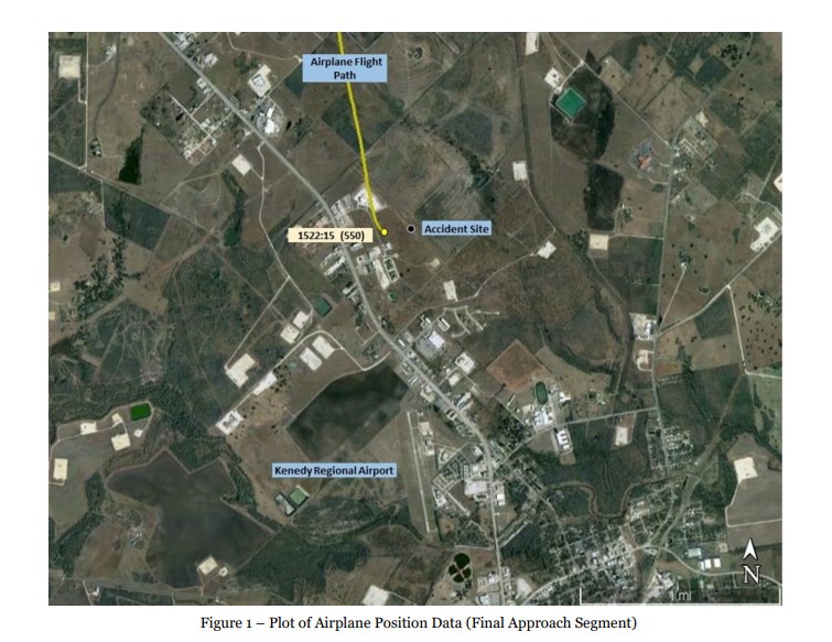
Automatic Dependent Surveillance – Broadcast (ADS-B) data revealed that the flight departed the New Braunfels National Airport (BAZ), at 1452 and proceeded southbound toward Kenedy Regional Airport (2R9), Kenedy, Texas. The airplane briefly reached an altitude of 6,300 ft mean sea level (msl) before descending to 5,600 ft msl. About 1508, while the airplane was about 23 miles north of 2R9, the pilot initiated a descent that continued until the final data point. About 1516, the pilot appeared to alter course slightly to align with the extended centerline for runway 16 at 2R9. About 3 seconds before the final data point, the flight track depicted the airplane entering a gradual left turn, as shown in figure 1. The final data point was recorded at 1522:15 with a corresponding altitude of 550 ft msl.
The accident site was located about 0.8 miles north of the runway 16 approach threshold at an approximate elevation of 368 ft. This was about 0.12 miles east of the final ADS-B data point. A ground impact scar was located about 18 ft west of the airplane wreckage. The wreckage came to rest along a wire fence and tree line. The fuselage and both wings exhibited damage consistent with impact forces, and the cockpit/cabin area was compromised.

Aircraft and Owner/Operator Information
Aircraft Make: Cessna
Registration: N2118R
Model/Series: 182G
Aircraft Category: Airplane
Amateur Built:
Operator: On file
Operating Certificate(s) Held: None
Operator Designator Code: None
Meteorological Information and Flight Plan
Conditions at Accident Site: VMC
Condition of Light: Day
Observation Facility, Elevation: K2R9,289 ft msl
Observation Time: 15:15 Local
Distance from Accident Site: 1.05 Nautical Miles
Temperature/Dew Point: 37°C /21°C
Lowest Cloud Condition: Clear
Wind Speed/Gusts, Direction: 19 knots / 0 knots, 130°
Lowest Ceiling: None
Visibility: 10 miles
Altimeter Setting: 29.67 inches Hg
Type of Flight Plan Filed: None
Departure Point: New Braunfels, TX (BAZ)
Destination: Kenedy, TX (2R9)
Wreckage and Impact Information
Crew Injuries: 1 Fatal
Aircraft Damage: Destroyed
Passenger Injuries: 1 Fatal
Aircraft Fire: None
Ground Injuries: N/A
Aircraft Explosion: None
Total Injuries: 2 Fatal
Latitude, Longitude: 28.84258,-97.86662
Those who may have information that might be relevant to the National Transportation Safety Board (NTSB) investigation may contact them by email witness@ntsb.gov, and any friends and family who want to contact investigators about the accident should email assistance@ntsb.gov. You can also call the NTSB Response Operations Center at 844-373-9922 or 202-314-6290.

Raley Wayne


SAN ANTONIO, Texas — Federal transportation officials are investigating a Monday plane crash about 50 miles southeast of San Antonio that killed both people onboard, including the pilot, according to Texas Highway Patrol.
The pilot was identified as 32-year-old Carin Kopecki, a native of Hobson in Karnes County. The passenger was identified only as "a male minor."
The two were aboard a Cessna 182G Skylane that was making its way to Kenedy Airport when it crashed while nearing its destination around 3:30 p.m. A cause wasn't immediately provided by authorities.
First responders from the Karnes County Sheriff's Office, Karnes County EMS and multiple local volunteer fire departments.
Officials with the Federal Aviation Administration and the National Transportation Safety Board are conducting the investigation.
KENEDY, Texas – According to a preliminary report, a single-engine Cessna 182 that crashed on Monday took off from New Braunfels National Airport in New Braunfels, Texas. The plane headed towards Kenedy Regional Airport prior to crashing.
A National Transportation Safety Board investigator arrived on the scene on Tuesday. The wreckage will be recovered on Wednesday, June 8.
Once on the scene, the investigator will begin documenting the scene and examining the aircraft. The investigator will request radar data, weather information, maintenance records and the pilot’s medical records.
NTSB investigators will also look at the human, machine and environment as the outline of the investigation.
A preliminary report, including all the factual information learned to date, should publish 15 days after the accident.
At this stage of an investigation, it is too soon for NTSB to state a cause. The investigators will provide factual information when available.
Investigations involving fatalities, and other major investigations, usually take between 12 and 24 months to complete.


There appears to be zero information on this one, not even news reports. Really hoping it's not true! :(
ReplyDeleteSadly, it’s true. I know the airport well.
DeleteA windy Texas day.
DeleteCaptured data in ADS-B tracks shows thru 20:21Z / 3:21 pm local, news says it was about 5 pm / 22:00 Z.
METARS for the period:
K2R9 062215Z AUTO 15015G20KT 10SM CLR A2965
K2R9 062155Z AUTO 14015G21KT 10SM CLR 37/22 A2965
K2R9 062135Z AUTO 15016G20KT 10SM CLR 37/22 A2965
K2R9 062115Z AUTO 14018G24KT 10SM CLR A2965
K2R9 062055Z AUTO 16014G21KT 10SM CLR 37/20 A2966
K2R9 062035Z AUTO 15014G19KT 10SM CLR A2967
K2R9 062015Z AUTO 13019KT 10SM CLR 37/21 A2967
Tracks, to the extent that data was captured:
FA:
https://flightaware.com/live/flight/N2118R
Adsbx:
https://globe.adsbexchange.com/?icao=a1c0b9&lat=28.848&lon=-97.884&zoom=13.3&showTrace=2022-06-06&leg=2&trackLabels
She was a wonderful nurse, mother and wife
DeleteFlying is fun, but there is a hugely important learning curve for what frequently goes wrong, like stalls and spins close to the ground catching inexperienced pilots far too often by surprise, but by then it is too late. This may not be what happened here, but how often is this the reason that there are fatal crashes close to the ground? I think the training standards should be tightened up to where this is practiced very early on so as to become second nature. Even bigger gauges to show airspeed to where it does not have to be searched for in the background of gauges. Very sad, particularly the little boy who will never grow up.
DeleteVery sad, as it looks like she and her 5 year old son were on board. From her Instagram account, it looks like she loved her family and flying. A couple of sites have limited information on this accident.
ReplyDeleteI knew this super sweet lady, always smiling and happy. She will be missed by so many.
ReplyDeleteHow awful and tragic. Looking at the ADS-B flight data, she was in an apparent normal albeit shallow straight in approach to 16 into 2R9 (a 289' MSL airport). The last return reading was at 1200' with a 300fpm descent rate about 3 miles out from the runway. About the only thing that even stands out is why are nearly 1,000' of ADS-B descent data not logged?
ReplyDeletehttps://flightaware.com/live/flight/N2118R/history/20220606/2016Z/KBAZ/L%2028.86323%20-97.87429/tracklog
RIP to both and condolences to those who loved and knew them.
Reception of ADS-B signals transmitted from aircraft depends of proximity to the ground receiver to the aircraft. There are FAA ground receivers and volunteer ground receivers. Results vary by where the aircraft is located.
DeleteI understand that, but the readings were just very consistent up to a point on the same flight path. That's what is unusual. The signal reporting just stopped and never picked back up. Random drops and gaps - even extended ones with no coverage - are expected in more rural areas but this was hardly a rural area with towns all around (including the Kenedy they were just a few miles from).
DeleteI am one of the people that has one of the "volunteer" ADSB receivers and I live 6 miles from town, right on an IFR route with a fix just to the east of me. Aircraft at cruise don't pop in and out, they just show up about a mile from me and disappear about a mile the other way. I need to improve my antenna to get more range. Kenedy is what most people would call rural. I just drove through there today. My mom was from Runge.
DeleteRF reception (and transmission) is affected by all kinds of things. Trees, water, the ground, antenna location, antenna polarization, antenna direction, etc. The aircraft she was flying got below the minimum height for the receiver to receive her signal. It's that simple.
This is typical, hardly “unusual” if you’ve seen such data before and understand the limitations. Most of my aircrafts’ fights start/stop showing up ~800’ AGL, depending on the location.
DeleteAs I was exiting Walmart my 3 yr old said mommy , big plane. It was flying very low heading to the Kenedy Airport. It just seemed lower in my opinion and didnt think much else since it looked like it was doing a round or fixing to land. The reason why I noticed was because the shadow plane of the plane went directly over my car startling me when I saw the bright sun and then instantly the the large area of shade moving right above which caused me to hit my breaks as I turned left and driving 181 south .I did say wow that went right over us to my daughter
ReplyDeleteAre you certain it was the accident aircraft? The turn from Walmart onto 181 is only 1500 feet from the RW 16 threshold. Asking only because the location shown on a Kens5 news graphic showed a location much farther away from the airport.
DeleteWhile sitting at the light before making that left turn, marker balls to warn aircraft are visible on the power lines behind the traffic signal:
StreetView photo:
https://goo.gl/maps/mA9QokcqKwtCAZhX7
Scroll down and open the dual track in Adsbechange that shows the second aircraft nearby that circled an area after the crash. Looks like the accident aircraft position marked in the Kens5 graphic was correct.
DeleteThere are huge areas that ADSB doesn't cover. On a somewhat recent flight from KFMN to KCEZ to KCNY at 10,500 ADSB didn't cover at least 3/4 of the area we flew through.
ReplyDeleteThis is particularly true for 978mhz UAT ADS-B which is frequently used by smaller GA aircraft. People can help change this though. You can build your own relatively cheap dual band Flight Feeder and feed ADS-B traffic to FlightAware and ADS-B exchange in return for a free business account.
DeleteMine feeds FlightRadar24. I have another one for FlightAware but I haven't had time to assemble it and put it in the air.
DeleteYou don't need a second receiver just to feed to another site. It's easy to set up a single receiver to feed to multiple sites, such as FR24, FlightAware, and don't forget to feed to ADS-B exchange which is completely uncensored.
DeleteThat's good to know. FR24 gets me Premium coverage. I'll probably add ADS-B exchange and leave it at that.
Delete" ADS-B exchange which is completely uncensored"
DeleteIncorrect.... Most are, but not "ALL"
If you have a1090 MHz ADS-B equipped aircraft, you can request, and apply for a "PIA" account which assigns a temporary ICAO aircraft address to the flight. It hides owner info and, aircraft tail #, but still shows the aircraft onscreen with no ownership info.
ADS-B PIA Definition see here:
https://www.faa.gov/air_traffic/technology/equipadsb/privacy/
I'm pretty sure the flight feeders only use 1090 so wouldn't help 978.
DeleteHate to see this. Inexperienced pilot (received PPL on 11/30/2021) in 15-18 knot winds that were gusting to 25 knots. Prayers to the family and friends that will miss this young pilot.
ReplyDeleteThe problem with that is that she was flying almost directly into said winds from the southeast right from the Gulf. They were not gusting sideways or from the rear. Totally manageable winds in a 152, let alone a 182...so long as said winds are pointed *at* your nose. I learned how to fly on the Gulf Coast and know how those winds can be. If you are landing on a southerly runway into northerly winds from the Gulf, you are in the best landing conditions possible, especially straight in as she was approaching. We'll have to wait for the preliminary. This was an old 182 (1964 model), so I'm sure control cable wear will be one of the first things the NTSB will be looking at.
DeleteTo anonymous, 15-18G25 in a 152? It’s no wonder have so many pilots dying doing dumb things.
DeleteToo slow while in a gust on the nose of long duration can lead to a stall when the gust trails off. If she wasn't doing a straight-in approach, pattern turn stalls in gusty conditions are a similar peril for lesser experienced pilots.
DeleteAnyone who thinks a 15-18G25 wind in a 152 is dangerous or dumb needs to get some dual or find something else to do.
DeleteThe 152 and most other light airplanes - including taildraggers such as the three I own - are completely manageable in those conditions in the hands of a properly trained pilot. If your instructor is not willing or able to teach you how to fly in those conditions, find another instructor and get the training you need.
Even pilots who just fly for fun and choose not to fly in suboptimal conditions should still obtain and maintain proficiency in gusty wind conditions because one of these days, even they will get caught out when conditions change abruptly and their "clear and a million, winds calm" pleasure flight gets interrupted by challenging conditions. Unfortunately, lots of young instructors are inexperienced themselves and unwilling to jeopardize their progression to the airlines by flying or training in challenging conditions. Their students and general aviation safety statistics bear the cost of this apprehension by creating a large swath of pilots who are unable to safely operate their airplanes in anything other than ideal conditions.
I'm don't know if all C182's have a max demonstrated xwind component of 15 kts, but that's what is in the C182 manual I have. Max demonstrated is not max if you spend time training.
DeleteI think some (not you) aren't understanding that the correct term is crosswind component. If the wind is gusting 15 kts at 10 degrees off the nose, that is not 15 kts of crosswind component. To calculate it take 15 kts x sine(10 deg) = 2.6 kts. And yes I know the rules of thumb, it's just easy to do the math and more fun imho.
The accident aircraft ADSB data (from above) says she was on a heading of 169 deg at 20:21Z.
Metar data posted above around that time shows:
K2R9 062035Z AUTO 15014G19KT 10SM CLR A2967
K2R9 062015Z AUTO 13019KT 10SM CLR 37/21 A2967
20:15 130 at 19 kts = 169 - 130 = 39 degrees. Xwind component for that would be about 12 kts. or about .63 (63% of the total wind).
20:35 150 degrees 5kt gust. 169 - 150 = 19 degrees. Xwind component for a 5kts gust = .33 (33% of the total wind) x 5 = 1.62 kts of crosswind component.
The good ole E6B has a real nice tool for visualized xwind component built in.
I don't know what happened but I doubt crosswind played much, if any, part in this tragic accident. I've practiced (with an instructor) in legit 20 knot gusty and variable direction max crosswind component in an old C172B model, on purpose. I was looking forward to his call telling me to come fly and I was happy when I got it. We had l-r winds on landing and r-l winds on takeoff (airport is on top of a mesa and the winds swirl around the mesa). I did 8 touch and goes in the crazy spring winds we were having and the instructor did a touch and go and landing just to keep some skin in the game.
I feel for the people that have lost their loved ones. I'm sure they want to know what happened. It looks to me like the sky was her happy place. I can relate to that. RIP to the young lady and her son. Condolences to her loved ones. Embrace your grief, it's the least you can do to honor her memory.
The one (1) poor quality and distant photo of the aircraft shows the red bottom of the fuselage and the undersides of the white horizonal stabilizers. The aircraft is laying on its left side without wings, which leads to an assumption that both wings were torn off in the crash.
ReplyDeleteWe have a vaguely written report without additional photographs. Any attempt to draw conclusions at this time as to the cause of this tragic accident is pure speculation. However the above post by Lewis is likely spot on. It's likely mid-afternoon gusting winds caused a loss of control on a low altitude approach.
Photo looks as if cockpit rearward is crushed.
DeleteShe nosedived from 300'. Flying too slowly.
ReplyDeleteAre you speaking as an observer of the incident or have other info to substantiate your comment?
DeleteShe had an app that tracked altitude, course, etc.
DeleteThe purpose of the app was so her husband could track her progress.
DeleteIf one of you commenting knows the husband, please advise him of the second aircraft that was nearby and converging on 2R9 at the time, as shown in a later comment. That pilot would have heard CTAF transmissions made by the accident pilot and was in a position to witness the crash, as indicated by track position beforehand and circling afterwards.
DeleteThe second aircraft is registered to a Georgetown, TX owner. ADS-B track for the accident day suggests that the second aircraft completed a landing at Kenedy and also had a takeoff from 2R9 with return to Georgetown showing up on the day after the accident.
Comment link, detailing second aircraft:
http://www.kathrynsreport.com/2022/06/cessna-182g-skylane-n2118r-fatal.html?showComment=1654965704112#c3517975179931441967
There is no mystery as to the second aircraft.
DeleteWitness report by the second aircraft on what was seen as the accident aircraft went down and/or CTAF transmissions from the accident pilot may be included in the preliminary if significant.
DeleteGusty conditions increase final approach speed by one half the gust factor, not to exceed 10 knots.
ReplyDeleteVaried back pressure to maintain altitude.
Ailerons to maintain bank angle.
Rudder to maintain coordinated flight.
Power to maintain airspeed.
https://www.jberaeroclub.com/uploads/1/7/4/0/17405139/c182maneuversguiderev2.pdf
Quite the handful for any inexperienced, low-time pilot in the notorious Texas winds.
DeleteWhich have been rather notorious for the last few months, especially in Kenedy.
Deleteand a hot day (37C/99F) with gusty winds over 20 KTS. ouch. And an old C-182 with no a/c. double ouch.
DeleteShe was on a 170 MH for Rwy 17 with 74 KT g/s (per ADSB). K2R9 AWOS had airport winds 140 at 19 knots. Probably a bit higher at 800' AGL, say 20 KT. H/W component is 17 KT, Left X/W component is 10 KT. If she suddenly lost that H/W, then 74 - 17 = 57 KT. C182 Stall speed light load, no flaps is about 50 KT. But if gusts were to 26 KT, then H/W component can be up to 24 KT, so now 74 - 24 = 50 KT. Now C-182 Aircraft airspeed suddenly drops, aircraft enters stall if no flaps and headwind component suddenly drops to near zero as she gets closer to ground. And if she pulls back on the yoke instead of pushing the nose down and putting in max power, well we all know what happens next...
ReplyDeleteIs it not true that a 74 kt groudspeed + 17 kt headwind = 91 kt airspeed? So if the headwind suddenly goes away: 91 kt - 17 kt = 74 kt airspeed?
DeleteTrue. That 57/50 knot possible airspeed assertion is incorrect. You can't have airspeed that is lower than the ADS-B reported ground speed unless you are in a tailwind.
DeletePhysics 101. She slowed after the last ADSB. The physics of momentum, momentum = mass (times) inertial velocity. The low-mass airflow slacked-off quickly as the ground environment approached, her airplane's inertial velocity did not. This leaves the slow flying plane hanging at the edge of stall speed. Her VVI showed a high sink rate, she pulled back but her airspeed was gone. Slammed the power, tried to correct torque yaw/roll with aileron and the aircraft snapped Left nose down into the ground from 250'-300'.
DeleteIs that "She slowed after the last ADSB" idea based on actual data from her app, or just speculation? Is this more of the same from the commenter who claimed headwind should be subtracted from ground speed to figure air speed?
DeleteThis is all speculation. The ADS-B track does not show the last minute or two of flight.
DeleteGround speed/airspeed comment poster above: No. Just stop posting.
DeleteI think the people here have nailed the cause of this crash. Simple inexperience with weather. However, this one hits me where I live. This could have been my daughter and grandchild.
ReplyDeleteHow I survived the same things before becoming a real pilot is beyond me.
When my wife flies with me, she disputes the "real pilot" appellation.
She was a real pilot. I wonder about her instructor. You have to remember, as an instructor, you have to remember that your students will fly like you fly, just without your experience. Winds 17 gusting 25 and taking your kid out? I don’t understand that choice. I did a full preflight the other day, taxied out, did my runup, called for takeoff, didn’t like the winds and told tower “never mind, the winds exceed my personal minimums”. Turned around taxied back in. Could I have flown safely in the conditions? Yup. But I have no need to prove it. Live to fly another day.
DeleteI've been flying out of the Four Corners region for the last 3-1/2 years. This year has been a bit odd for winds. More so than usual. The airport is in a mesa, the winds swirl (L-R on approach, R-L on departure), LLWS is a thing, DA's over 9,000' are a thing. The winds haven't let up like they usually do. I've practiced very sporty winds (worse than the day of this crash) with an instructor up there but I don't schedule to fly cross country or recreational when the winds are excessive and/or low level turbulence is forecast to be moderate. I don't "have" to fly. That said, I have flown and managed just fine.
DeleteI didn't look at the ADSB data but the comments from people that did make it sound like she "dragged it in". By that I mean the approach wasn't on a 3 degree glideslope, it was a flatter approach. A 10kt gust factor and steeper approach would have made the winds more manageable. Not great but more doable. A longer, higher approach gives you time to assess the winds, wind shear if that's an issue, variable direction if that was an issue, etc.
The terrain can make the winds "roll", even if it's just mesquite. I think of wind as low density water. It helps me to visualize how it flows over, through, and around objects on the ground. As it comes up against the slope of a mesa I know it's going to "splash up" (or flow down if it's the departure end OR the cross wind angle is sharp enough). It's not going to be a smooth transition, especially when cross wind is involved.
I agree, she was a real pilot. I wonder how many "real pilots" here flew perfectly from the first day they had their ticket. Back when I got my ticket I took my family flying. Today? I make sure I know the airport, the area, and the aircraft before I take anyone with me. I put 18.2 hours on a C172R (Cutlass RG) and the only person that I took with me was a CFII for 10 hours of that time. I think he was bored the last 5 hours but I wanted to do some long cross country flights and focus on learning how to use the autopilot and GPS.
It's heartbreaking that her husband lost his family, their parents lost a granddaughter and grandson, and the area lost a "wonderful, mother, wif, and nurse".
Saying "I didn't look at the ADSB data" misses out on gaining insight available from comparison to prior RW16 landings at 2R9.
DeleteHere is an April 14, 2022 landing with ADS-B data coverage almost all the way to the pavement. Notice the wind reports from the period, not a calm day. Add 90 feet to get approximate true altitude from the 29.92-referenced ABS-B reported data:
https://globe.adsbexchange.com/?icao=a1c0b9&lat=28.849&lon=-97.889&zoom=12.7&showTrace=2022-04-14&leg=2&trackLabels
K2R9 141835Z AUTO 11012G21KT 10SM SCT060 29/05 A3001
K2R9 141855Z AUTO 10016G22KT 10SM SCT060 29/03 A2999
For comparison, here is the accident day track to the extent that data was captured, framed so that switching browser windows between it and the other tracks in this post will present as overlays to the same background:
https://globe.adsbexchange.com/?icao=a1c0b9&lat=28.849&lon=-97.889&zoom=12.7&showTrace=2022-06-06&leg=2&trackLabels
Associated field wx, from mesonet.agron.iastate.edu:
K2R9 062115Z AUTO 14018G24KT 10SM CLR A2965
(ADS-B reported altitudes are 270 feet less than true)
Three more N2118R RW16 landings with field wx:
https://globe.adsbexchange.com/?icao=a1c0b9&lat=28.849&lon=-97.889&zoom=12.7&showTrace=2022-05-09&trackLabels
K2R9 090055Z AUTO 14015G20KT 10SM SCT025 29/23 A2966
K2R9 090115Z AUTO 14014G21KT 10SM SCT023 28/23 A2967
(ADS-B reported altitudes are 260 feet less than true)
https://globe.adsbexchange.com/?icao=a1c0b9&lat=28.849&lon=-97.889&zoom=12.7&showTrace=2022-05-16&leg=2&trackLabels
K2R9 160115Z AUTO 14010KT 10SM CLR 30/19 A2987
(ADS-B reported altitudes are 50 feet less than true)
https://globe.adsbexchange.com/?icao=a1c0b9&lat=28.849&lon=-97.889&zoom=12.7&showTrace=2022-05-26&leg=2&trackLabels
K2R9 261835Z AUTO 18005KT 10SM CLR 33/16 A2997
(ADS-B reported altitudes are 50 feet greater than true)
To me it sounds like and now looks like it was a long approach, straight in, and the decent rate wasn't stabilized. The April 14 approach looked much better. Distracted? Hot day, a little rough? Maybe not feeling too good?
DeleteI wonder of she trained in a C182. Switching from a C150 or C172 to a C182 isn't a huge change but it's definitely a change.
Appears that she trained in the C182 accident aircraft (that she had owned since March of 2020) when you look back through the ADS-B history.
DeleteHere is an example from last November, before the PP cert date:
https://globe.adsbexchange.com/?icao=a1c0b9&lat=28.849&lon=-97.889&zoom=12.7&showTrace=2021-11-10&trackLabels
K2R9 101855Z AUTO 18009G15KT 10SM SCT039 BKN047 BKN055 27/18 A2990
Lots more gusty N2118R days/approx time/WX flights:
2022-04-28 22:47Z, K2R9 282235Z AUTO 12015G21KT
2022-04-01 17:36Z, K2R9 011735Z AUTO 12010G19KT
2022-03-24 17:53Z, K2R9 241735Z AUTO 31013G19KT
2022-02-15 17:55Z, K2R9 151735Z AUTO 15017G22KT
2021-12-22 22:30Z, K2R9 222235Z AUTO 16011G14KT
2021-11-24 16:31Z, K2R9 241635Z AUTO 17014G19KT
2021-11-16 16:36Z, K2R9 161635Z AUTO 18019G24KT
The pilot landed that C182 at 2R9 many times when wind was not calm.
Another aircraft nearby was converging on the field, as seen in the combined track of both aircraft, below. The converging aircraft's circling after the crash suggests the crash location.
ReplyDeleteUnanswered questions include: What did the pilot of the second aircraft see, what communications about intentions did the two pilots make and hear, and was the second aircraft's presence nearby disruptive to the C182 continuing a straight-in approach?
You can click-move the accident aircraft along it's data points or do a play through and observe the related position of that second aircraft:
https://globe.adsbexchange.com/?icao=a1c0b9,a03fc0&lat=28.847&lon=-97.872&zoom=13.3&showTrace=2022-06-06&leg=2&trackLabels
the slightly left of extended Rwy centerline supports the inference the aircraft initially rolled left as she jammed the power in to stop fast delevoping, dangerous sink rate as the stall buzzer was blaring. But as is seen so often, corrected the left roll with left aileron, instead of right rudder, and pulling back on the yoke in the panic of the sink rate, resulting in a nose down left 1/2 to 3/4 turn spin to impact near vertical.
DeleteI meant "right aileron" not left aileron. Right aileron with a left banked left stalled wing further increases wing aoa and drag inducing more left spin.
DeleteSad. I recently got my PPL so this hit home, she only got her license in November. Kid with her also... Thoughts & Prayers to her family and husband.
ReplyDeleteflying an older 182 with no fuel injection i had several occasions of carb ice. you dont get much waring with the constant speed prop keeping rpm up. it loses power rather suddenly.
ReplyDeleteSeems like an important point, given that the pilot's flight history in managing gusts suggests that a straight in fail on winds alone is not likely.
DeleteThe 37C/99F air temp and 20C/68F dewpoint does put you in the blue zone of the carb icing chart. More prone to icing being a carb'd Continental than if it were a carb'd Lycoming,
Carb Icing chart is on page 2 at:
https://rgl.faa.gov/Regulatory_and_Guidance_Library/rgSAIB.nsf/dc7bd4f27e5f107486257221005f069d/f319315cfc90c3f7862575e500439fa0/$FILE/CE-09-35.pdf
registration shows a Continental O-470 engine.
DeleteThe stock 1964 Cessna 182G is powered by the Continental carbureted 230 hp (172 kW) Continental O-470-L or O-470-R piston engine. Gross weight 2,800 lb. (1,270 kg) and certified on 19 July 1963.
DeleteI'm not a pilot. I did cosmetic work on single engine aircraft for a but I digress. As a parent, and someone who has lost more family members than I care to divulge here, there are certainly better ways to ascertain a situation than to use selfies as a measure. Please bear in mind that this was someone's wife, mother, aunt, sister and daughter. As with any other accident, we can pick apart data all we want, but we weren't the ones on the stick.
ReplyDeleteThe GA community has a training issue the sooner the FAA addresses it the better. ABCs of an emergency have to be automatic. There is an estimate that you will survive 70% or more of emergencies if you pick best airspeed and a landing spot then fly all the way to the crash. This has to be done without hesitation.
ReplyDeleteShe flew into my home airport not long ago. She was very nice and seemed to be a very competent pilot. Hate to see this. I don’t think this would have been because of not being competent. Hope her husband can find some peace.
ReplyDeleteI'll be 80 years old next week. I do a rental checkout at a local field whenever I travel outside of Southern California. Very often, the CFI criticizes me for coming in to land a bit high and departing after the touch-and-go too flat. So far, I haven't crashed on approach or spun out on departure - could happen, I guess.
ReplyDeleteSurprising that no information on control cable continuity, engine condition basic checks, or witness accounts are included in the preliminary report.
ReplyDeleteI owned this aircraft in the early 80's (about 1981 or 1982) So sorry to hear. RIP
ReplyDeleteSeems to be some decent aviators with valuable input to give a glimpse of what may have happened. While flying in 15-20 knots spreads may not sound like a huge chore, it is definitely not for the inexperienced pilot. Having 3k hours in rotorcraft I barely feel "ok" at my skill level. I frequently fly in 10 to 15 knot gusts in the san antonio area. I may have the aircraft in a level attitude, at or slightly above ETL, stabilized approach, and those winds can quickly produce a 500 fpm decent rate.
ReplyDelete