
The National Transportation Safety Board traveled to the scene of this accident.
Additional Participating Entity:
Federal Aviation Administration / Flight Standards District Office; Boise, Idaho
Location: Challis, Idaho
Accident Number: WPR22LA238
Date and Time: June 26, 2022, 19:45 Local
Registration: N1231C
Aircraft: Piper PA-20-135
Injuries: 2 Fatal
Flight Conducted Under: Part 91: General aviation - Personal
On June 26, 2022, about 1945 mountain daylight time, a Piper PA-20-135, N1231C, was substantially damaged when it was involved in an accident near Challis, Idaho. The pilot and passenger were fatally injured. The airplane was operated as a Title 14 Code of Federal Regulations Part 91 personal flight.
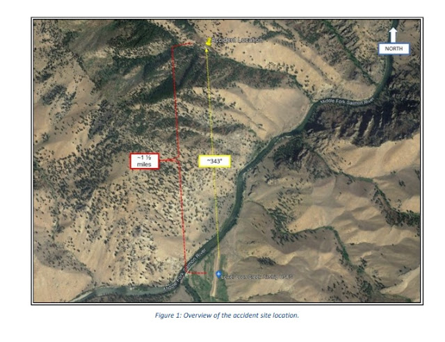
A friend of the pilot reported that he and the accident pilot were camping at Johnson Creek (3U2), Yellow Pine, Idaho. Earlier in the day they had flown to Lower Loon Creek Airstrip (C53), Challis, Idaho, and due to the density altitude, they waited to depart from C53 until later that evening for the return flight to 3U2. He further added that at the time of departure, the density altitude was indicating about 6,200 ft. He observed the accident airplane depart to the north, climb, and then turn back toward the runway about 1930. He last observed the accident airplane on a southbound heading. Shortly after departing from C53, he observed smoke, which he believed to be a small ground fire. After landing and refueling at McCall Municipal Airport (KMYL), he continued his flight to 3U2 where he expected to meet with the accident pilot and passenger. They had not arrived, and he reported N1231C as missing. First responders located the airplane wreckage by air the following day about 1 ½ miles north of C53. On June 28, they accessed the accident site and reported that the airplane had impacted steep rising mountainous terrain at an elevation of about 4,200 ft mean sea level (msl) on an approximate southerly heading. The main wreckage came to rest upright about 30 ft below the first identified point of impact and was mostly consumed by fire. All major structural components of the airplane were observed at the accident site.
The wreckage was recovered to a secure location for further examination.

Aircraft and Owner/Operator Information
Aircraft Make: Piper
Registration: N1231C
Model/Series: PA-20-135
Aircraft Category: Airplane
Amateur Built:
Operator:
Operating Certificate(s) Held: None
Operator Designator Code:
Meteorological Information and Flight Plan
Conditions at Accident Site: VMC
Condition of Light: Dusk
Observation Facility, Elevation: KLLJ, 5040 ft msl
Observation Time: 19:55 Local
Distance from Accident Site: 32 Nautical Miles
Temperature/Dew Point: 30°C /-2°C
Lowest Cloud Condition: Clear
Wind Speed/Gusts, Direction: / ,
Lowest Ceiling: None
Visibility: 10 miles
Altimeter Setting: 30.21 inches Hg
Type of Flight Plan Filed: None
Departure Point: Challis, ID (C53)
Destination: Yellow Pine, ID (3U2)
Wreckage and Impact Information
Crew Injuries: 1 Fatal
Aircraft Damage: Substantial
Passenger Injuries: 1 Fatal
Aircraft Fire: Fire at unknown time
Ground Injuries:
Aircraft Explosion: None
Total Injuries: 2 Fatal
Latitude, Longitude: 44.822667,-114.82533
Those who may have information that might be relevant to the National Transportation Safety Board (NTSB) investigation may contact them by email witness@ntsb.gov, and any friends and family who want to contact investigators about the accident should email assistance@ntsb.gov. You can also call the NTSB Response Operations Center at 844-373-9922 or 202-314-6290.
Aircraft crashed under unknown circumstances.
Date: 27-JUN-22
Time: 01:45:00Z
Regis#: N1231C
Aircraft Make: PIPER
Aircraft Model: PA20
Event Type: ACCIDENT
Highest Injury: FATAL
Total Fatal: 2
Flight Crew: 1
Pax: 1
Activity: PERSONAL
Flight Phase: EN ROUTE (ENR)
Operation: 91
Aircraft Missing: No
Damage: SUBSTANTIAL
City: CHALLIS
State: IDAHO


earlier sad details of father and son, RIP. https://www.eastidahonews.com/2022/06/adult-and-teenager-killed-in-rural-idaho-plane-crash/
ReplyDeletePlane registered in Florida, decedents having moved from there to Idaho, 8 pm departure, mountainous terrain high elevations, back country airstrips - according to East Idaho news.
ReplyDeleteAn 8 PM departure from Lower Loon Airstrip to Johnson Creek strip (Yellow Pine) was likely not a wise choice. Sunset would have been around 8:30 PM, and even flying in the remaining 1/2 hr. limelight would have been quite treacherous in those mountains. Especially for a Florida flat-land pilot. Appears to be CFIT with a mountain in low light.
ReplyDeleteFlying into (and out of) those backcountry Idaho airstrips is a handful, even for experienced pilots. Johnson creek is more than a handful - one way in, one way out. Approach is a 360 spiral down in a tight 1,000 foot canyon above Yellow Pine, then a southerly final towards a mountain rock face that completely hides the airstrip, then a left hard rudder to avoid the mountain, and there in front of you is the airstrip a few hundred yards ahead. Made the landing work ...do not attempt a go-around ... you won't make it! Those who have tried have left the souls at Johnson Creek.
DeleteLooking at Lower Loon and Johnson Creek landing videos, the Lower Loon arrival isn't for the faint hearted, either:
DeleteLL:
https://youtu.be/bTV4eEVStkM
JC:
https://youtu.be/qFGVxWaXPAA
Anyone know the distance/flight time from Lower Loon to Johnson Creek ... say 110 knots airspeed? Don't have a sectional for Idaho.
DeleteJust trying to figure if the PA-20 pilot had enough time get from Lower Loon to Johnson Creek before dark... info is he left Lower Loon at 8 pm.
8 pm flight time may have been chosen to get a lower temperature for the 4100' Elevation, 1200' runway C53 takeoff.
DeletePhoto from 2018:
https://www.shortwingpipers.org/forum/attachment.php?s=3e22df759b74aa802dade8986bbd6f5e&attachmentid=14525&d=1544385930
Lower Loon to Johnson Creek is 30 miles.
DeleteDoable to Johnson Creek in about 20 minutes or less in the Pacer.
DeleteTo the previous poster: you should NEVER EVER "Spiral down" into a backcountry airstrip in a canyon - good way to get yourself killed. It is possible to fly a normal traffic pattern at Johnson Creek (which is not at all "tight") even in a light twin aircraft.
ReplyDeleteI fly a fast Bonanza into Johnson Creek a lot doing a standard traffic pattern. To the poster who said you spiral down has no clue what he is posting about.
ReplyDeleteThe pilot was an experienced and capable in back country flying . He was doing what he loved with his boy. He was flying the plane he could afford and doing what he others only think of. He will be missed as will his son by those who knew and cared sometimes it’s not about you or what you think
ReplyDeleteThank you for posting a little defense of the pilot. I'm his cousin, also a pilot. We talked many times of the risks of mountain flying, he had flown from FL to ID on multiple cross country trips, had been in and out of Johnson Creek many times. He was not a rookie flat lander as some imply, yes he did wait until late afternoon due to air temp, we had talked about that before. Sad that the NTSB takes so long to complete these investigations, but hopefully they might find find some clues other than "pilot error", time will tell. Great guy and wonderful son, greatly missed !
DeleteThere’s plenty of light late June to leave lower loon and return to Johnson creek. The rancher who witnessed their departure stated that they departed fine but then turned left (west) into a high terrain canyon, off of the middle fork drainage. With a face full of sun and high terrain it seems an attempt to turn back was nearly successful. My heart goes out to the loved ones of those lost. Be safe out there folks.
ReplyDelete