
The National Transportation Safety Board traveled to the scene of this accident.
Additional Participating Entity:
Federal Aviation Administration / Flight Standards District Office; Las Vegas, Nevada
Location: Boulder City, Nevada
Accident Number: WPR22FA109
Date and Time: February 24, 2022, 13:40 Local
Registration: N588V
Aircraft: DISTAR CZ AS D 13/15 SunDancer
Injuries: 1 Fatal
Flight Conducted Under: Part 91: General aviation - Positioning
On February 24, 2022, about 1340 Pacific standard time, a Distar CZ AS, Sun Dancer, N588V, was destroyed when it was involved in an accident near Boulder City, Nevada. The pilot was fatally injured. The motor glider was operated as a Title 14 Code of Federal Regulations Part 91 repositioning flight.
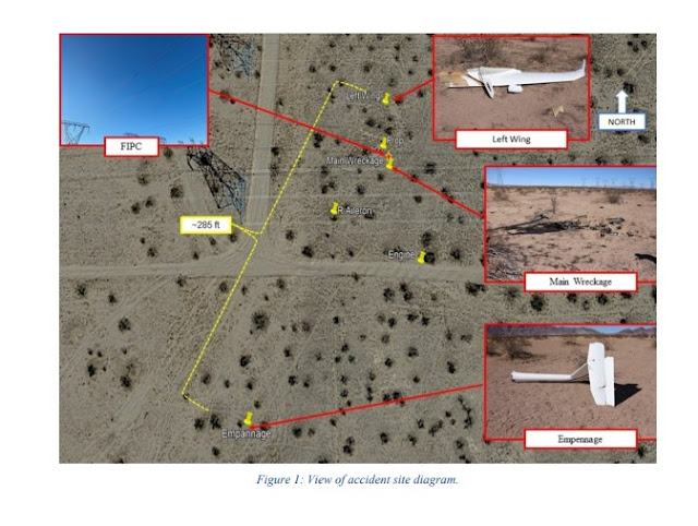
First responders reported that, it appeared that the motor glider had impacted 3 power lines. The power lines were about 60 ft above the surface, running east to west, black in color with debris entangled within the power lines. The debris field was located to the south of the power line and the main wreckage was nearly directly below the black in color power lines.
Recorded Automatic Dependent Surveillance-Broadcast (ADS-B) and L3Harris' OpsVue data showed that the motor glider departed from the Boulder City Municipal Airport at 2115:52 on a westerly heading, ascended to 2,850 ft mean sea level (msl) before a left turn was initiated. At 2117:58, the motor glider continued to ascend in a left turn and reached an altitude of 3,100 ft msl before a descent began. The data showed that the motor glider continued descending on an easterly heading until contact was lost at 2119:35, at an altitude of 2,375 ft, about 1 mile northwest of the accident site.
Examination of the accident site revealed that, the main wreckage (cockpit and forward fuselage) came to rest upright on a heading of about 172° magnetic, at an altitude of 1,869 ft msl. The first identifiable point of contact (FIPC) were 3 power transmission lines about 60 ft above the surface, about 1.5 mile southwest of the departure end of runway 27. The power lines were black in color with entangled debris within the power transmission lines. The debris field was located on flat, desert terrain, and was about 285 ft in length and 100 ft wide, as seen in figure 1. The main wreckage was located beneath the FIPC. Wreckage, to include system components, flight control surfaces was scattered throughout the debris path.
The wreckage was recovered to a secure location for further examination.
Aircraft and Owner/Operator Information
Aircraft Make: DISTAR CZ AS
Registration: N588V
Model/Series: D 13/15 SUN DANCER
Aircraft Category: Glider
Amateur Built:
Operator:
Operating Certificate(s) Held: None
Operator Designator Code:
Meteorological Information and Flight Plan
Conditions at Accident Site: VMC
Condition of Light: Day
Observation Facility, Elevation: KBVU, 2202 ft msl
Observation Time: 13:35 Local
Distance from Accident Site: 2 Nautical Miles
Temperature/Dew Point: 9°C /-15°C
Lowest Cloud Condition: Clear
Wind Speed/Gusts, Direction: 8 knots / , 150°
Lowest Ceiling: None
Visibility: 10 miles
Altimeter Setting: 30.21 inches Hg
Type of Flight Plan Filed:
Departure Point:
Destination:
Wreckage and Impact Information
Crew Injuries: 1 Fatal
Aircraft Damage: Substantial
Passenger Injuries:
Aircraft Fire: On-ground
Ground Injuries:
Aircraft Explosion: None
Total Injuries: 1 Fatal
Latitude, Longitude: 35.929557,-114.88421 (est)
Those who may have information that might be relevant to the National Transportation Safety Board (NTSB) investigation may contact them by email witness@ntsb.gov, and any friends and family who want to contact investigators about the accident should email assistance@ntsb.gov. You can also call the NTSB Response Operations Center at 844-373-9922 or 202-314-6290.


The crash site appears to be just south of KBVU and about 6 miles SW of Hoover Dam. Since the dam is a hydroelectric plant, the terrain there is filled with power lines.
ReplyDeleteLooks like the biggest group of transmission lines was a little further away. Not much altitude gain after takeoff.
DeleteTrack:
https://globe.adsbexchange.com/?icao=a7957b&lat=35.944&lon=-114.897&zoom=13.5&showTrace=2022-02-24&trackLabels
NTSB Final Report: Drunk, drunk and drunk with a chaser of diphenhydramine, just to make sure he stayed drunk.
ReplyDelete