
The National Transportation Safety Board traveled to the scene of this accident.
Additional Participating Entity:
Federal Aviation Administration / Flight Standards District Office; Fresno, California
Location: Visalia, California
Accident Number: WPR22FA054
Date and Time: December 4, 2021, 18:40 Local
Registration: N7933M
Aircraft: Beech V35
Injuries: 4 Fatal
Flight Conducted Under: Part 91: General aviation - Personal
On December 4, 2021, about 1840 Pacific standard time, a Beech, V35, N7933M, was substantially damaged when it was involved in an accident near Visalia, California. The pilot and 3 passengers were fatally injured. The airplane was operated as a Title 14 Code of Federal Regulations Part 91 personal flight.
A witness located near the accident location reported that, while in her residence, she heard an airplane flying very low, followed by the sound of the airplane impacting terrain. Concerned, she then notified first responders.
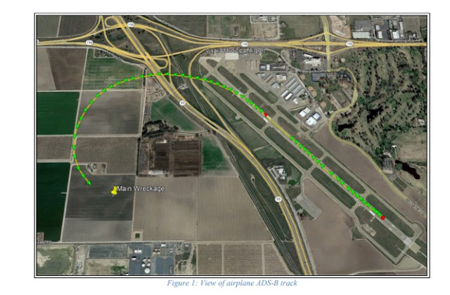
Recorded Automatic Dependent Surveillance-Broadcast (ADS-B) data provided by the Federal Aviation Administration (FAA) showed that the airplane departed from runway 30 at 0237:01 and ascended to 400 ft msl before a left turn was initiated. The data showed that at 0237:26, the airplane continued to ascend in a left turn and reached an altitude of 525 ft msl before a descent began. The data showed that the airplane continued descending in a left turn until ADS-B contact was lost at 0237:37, at an altitude of 300 ft msl, about 660 ft northwest of the accident site as seen in figure 1.
The airport’s automated weather observation station reported that, at 1847 Pacific standard time, the wind was from 300° at 6 knots, visibility of 1 ¼ statute miles, ceiling overcast at 300 feet agl, temperature of 9°C and dew point temperature of 9°C, altimeter setting of 30.25 inches of mercury.
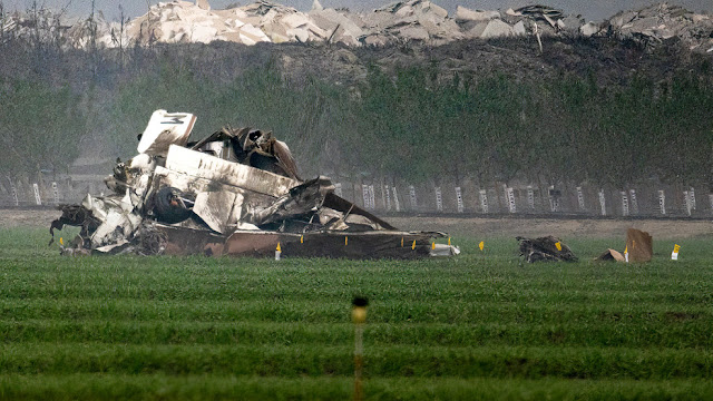
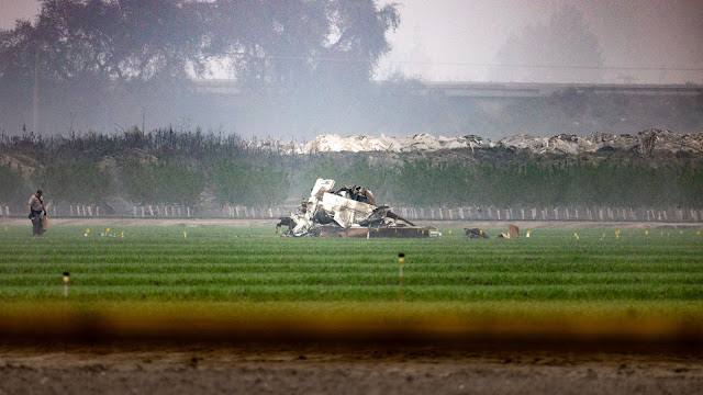
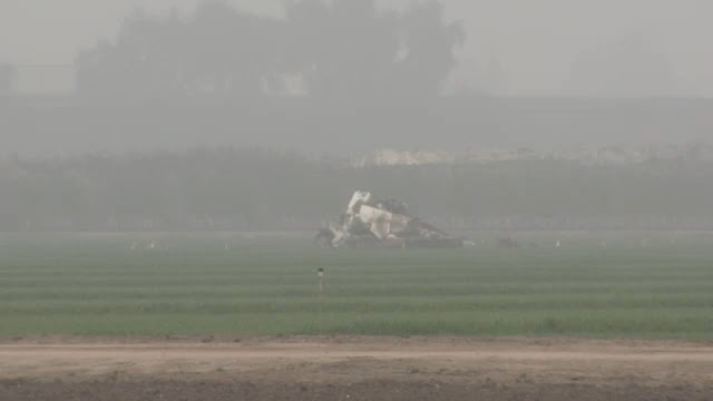
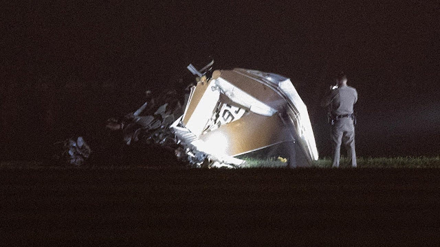
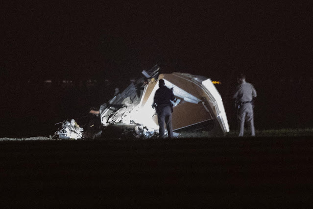
Examination of the accident site revealed that the airplane impacted terrain about 1 mile southwest of the departure end of runway 30. The airplane came to rest on its left side, on a heading of about 265° magnetic, at an altitude of 290 ft mean sea level. The first identified point of contact (FIPC) with terrain was a ground scar/impression that was 285° magnetic and about 345 ft from the main wreckage. The ground scar/impression was about 14 ft long, 22 inches wide and 3 inches deep. The debris field was located on flat, open wheat field, on a magnetic heading of 285° degrees from the airplane, about 345 ft in length and 200 ft wide. The first identified piece of wreckage was located about 330 ft from the airplane wreckage and consisted of the airplane propeller and propeller hub. Throughout the debris path, various portions of aluminum wing skin, left wing fragments, left aileron, engine, propeller, exhaust system, foam, and plexi glass were observed. The wreckage was recovered to a secure location for further examination.
Aircraft and Owner/Operator Information
Aircraft Make: Beech
Registration: N7933M
Model/Series: V35
Aircraft Category: Airplane
Amateur Built:
Operator: On file
Operating Certificate(s) Held: None
Operator Designator Code:
Meteorological Information and Flight Plan
Conditions at Accident Site: IMC
Condition of Light: Night
Observation Facility, Elevation: KVIS, 295 ft msl
Observation Time: 18:47 Local
Distance from Accident Site: 0 Nautical Miles
Temperature/Dew Point: 9°C /9°C
Lowest Cloud Condition:
Wind Speed/Gusts, Direction: 6 knots / , 300°
Lowest Ceiling: Overcast / 300 ft AGL
Visibility: 1.25 miles
Altimeter Setting: 30.25 inches Hg
Type of Flight Plan Filed:
Departure Point: Visalia, CA
Destination: Sacramento, CA (KSAC)
Wreckage and Impact Information
Crew Injuries: 1 Fatal
Aircraft Damage: Substantial
Passenger Injuries: 3 Fatal
Aircraft Fire: None
Ground Injuries:
Aircraft Explosion: None
Total Injuries: 4 Fatal
Latitude, Longitude: 36.3198,-119.40696
Those who may have information that might be relevant to the National Transportation Safety Board (NTSB) investigation may contact them by email witness@ntsb.gov, and any friends and family who want to contact investigators about the accident should email assistance@ntsb.gov. You can also call the NTSB Response Operations Center at 844-373-9922 or 202-314-6290.

On December 4, 2021 we unexpectedly lost our dear friend Karen Chelini Baker in a tragic accident that also took the lives of her beloved father, sister, and cousin. Karen was a loving wife to Brandon and devoted mother to their two children. She provided love and support for her family, friends, and community. We are devastated by this sudden loss.
We know that her family will now be facing many unexpected expenses, especially a funeral. There are many ways to help, however right now one of the best ways to show your love and support is through financial support. Any help you can provide will relieve the financial burden the family faces at this time.
All funds will be directly transferred to Karen’s husband, Brandon, by their friends (Monica Hernandez and Laura Quach Hoang).
If you're from the class of '94, please consider adding 94 to your donation — $94, $1994.

My name is Key Lewis, my long time friend Sam Bam, lost his amazing lady Donna Chelini, her father, her sister and her cousin to a tragic airplane accident on 12/4/21, The life the two of them built together in the last 11 years, and the joy they shared, will live on forever.

We are deeply saddened by the tragic loss of Stephen Chelini. He leaves behind his adoring wife, Espie, and their two daughters.
Anyone that had the pleasure of spending time with Steve and his family could see the bond and love for one another. As with any unexpected loss, we are left with feelings and questions - and a strong desire to help the family in some way. This fund is intended to help the family with funeral and memorial expenses.
The funds will be managed by his family.

Dave Chelini
SACRAMENTO, California — Friends of longtime Sacramento accordion teacher Dave Chelini are remembering him after his death in a plane crash over the weekend in Visalia, saying his legacy is the music created by scores of students he taught at Kline Music and the instruments he repaired over the years.
"They said Dave loved three things. There were 'three As.' There was the accordion, airplanes and automobiles," explained friend and fellow co-worker at Kline Music Nicolaus Meagher. "He knew how to use all of them. He could work on them. He was really a master of all of them."
Chelini, 78, and his two daughters, 46-year-old Karen Baker and 48-year-old Donna Chelini, were killed when their single-engine plane crashed in heavy fog minutes after takeoff, the Tulare County Sheriff's Office said. Dave's nephew Steven Chelini, 58, also died in the crash. The group had traveled to Visalia for a basketball game.
Dave Chelini got a job as an accordion teacher at Kline Music back in the 1960s.
Friends told KCRA that Chelini went on to work for SMUD for decades, but always wanted to return to teaching people how to play the accordion.
"The second he retired he came back, and he goes, 'I want to teach again,'" recalls Penny Kline, president of Kline Music.
Meagher said it was Chelini's love of music that brought him back to teach at the Sacramento music shop.
"He told me that, once he had time again to teach, that's what he wanted to do," Meagher said.
In recent years, Chelini mostly stuck to repairing accordions.
"He could take them apart and rebuild them," said Meagher. "He could take an old, antique accordion, that was an heirloom, and get it playing again."
Chelini would stop by the shop to pick up accordions people had dropped off -- eager to see if he could fix them.
If he couldn't, he'd let accordion owners know that, too.
"He was very honest, very honest and had a great reputation around town," Kline said. "Bring your accordion to Dave because he'll tell ya exactly the truth."
Chelini was a positive personality, friends described. A person who touched the lives of students, co-workers and musicians alike.
"We're gonna miss him, that's the only way I can put it," said Meagher. "His music's gonna live on with all these students that he taught."
VISALIA, California -- Authorities have identified the four people killed in a plane crash near the Visalia airport over the weekend.
The Tulare County Sheriff's Office says 78-year-old David Chelini, his 58-year-old nephew Steven Chelini, and his two daughters, 46-year-old Karen Baker and 48-year-old Donna Chelini were killed in Saturday's crash. The family is from the Sacramento area.
The Beechcraft V35 Bonanza aircraft took off from Visalia Municipal Airport at about 6:40 pm, then crashed just 16 seconds later at Road 68 and Avenue 288, just west of the airport.
Investigators from the Federal Aviation Administration (FAA) and the National Transportation Safety Board (NTSB) arrived in the South Valley on Sunday to begin looking into why the plane was derailed just moments after it took off.
First responders say the fog was thick when they arrived.
With no fire from the crash, it wasn't easy to immediately find the plane.
"When we all responded, we were searching for the plane," said Sgt. Jesse Cox with the sheriff's office.
"The area is a large reservoir area and it's hard to get back there. We need to go on foot... We just circulated the area as much personnel as we had until we found it," he added.
Once the plane was found, the sheriff's office confirmed all four people on board died in the crash.
The National Transportation Safety Board and Federal Aviation Administration arrived Sunday afternoon to take over the investigation.
The NTSB says the wreckage field from the crash is about 500 feet long, with debris scattered in all directions.
Investigators are taking photographs and conducting the ground investigation before the plane is moved to a secure location for further analysis.
Four people are dead after a plane crashed west of the Visalia Municipal Airport, sheriff's officials said.
Emergency crews responded after receiving a call just after 6:30 p.m. that a small plane was down near the airport. Detectives and deputies from the Tulare County Sheriff's Office are also on the scene of the crash near Highway 99 in Visalia.
The plane left Visalia Municipal Airport at 6:37 p.m., Sgt. Jesse Cox said. Around four minutes elapsed between takeoff and the first 911 call.
It took first responders some time to locate the wreckage due to the dense fog in the area. Photos of the wreckage show a crumpled cabin and debris in front of an orchard, near the Visalia Water Reclamation Facility on Avenue 288.
"It was dark. At the time, it was much foggier," Cox said. "We circulated the area with personnel until we found it (the wreckage)."
Deputies said ambulances and firefighters were at the scene shortly after the crash.
The National Transportation Safety Board is en route to the area and is investigating the crash of a Beech V35 Bonanza in Visalia. The Federal Aviation Administration as well as the National Transportation Safety Board are expected to arrive on Sunday.
A plane with the tail number N7933M left the Visalia airport at 6:37 p.m., according to flight records. The Beechcraft V35 Bonanza is registered to David Chelini out of Sacramento, according to a publicly searchable FAA database.
Detectives have not identified any victims.
Details surrounding the crash will have to wait until transportation safety officials complete their investigation, which could take weeks.


RIP. Video of plane.
ReplyDeletehttps://youtu.be/kXWAKBiOgdQ
SOUP @ 6:34 PM TEMP 46.5 °F DEW POINT 44.8 °F HUMIDITY 95 % West 0.9 mph 3.0 mph 29.96 in https://www.wunderground.com/dashboard/pws/KCATULAR18/table/2021-12-4/2021-12-4/daily
ReplyDeleteNo AWOS at KVIS.
DeleteMETAR from HJO (11 nm W) at 00:35 Z on UTC day 5 December:
KHJO 050035Z AUTO 30005KT 2 1/2SM BR OVC004 11/09 A3020
From:
https://mesonet.agron.iastate.edu/request/download.phtml?network=CA_ASOS
^ Dangit, 6:35 pm PST = 18:35, Correcting for UTC-8 = 02:35 Z
DeleteMETAR from HJO (11 nm W) at 02:35 Z on UTC day 5 December:
KHJO 050235Z AUTO 33007KT 2 1/2SM BR OVC004 10/09 A3025
KVIS does indeed have it's own AWOS:
DeleteMETAR from VIS at 02:35 Z on UTC day 5 December:
KVIS 050235Z AUTO 28004KT 2 1/2SM BR BKN003 09/09 A3023
From:
https://mesonet.agron.iastate.edu/request/download.phtml?network=CA_ASOS
So the METAR records from aviationweather.gov for KVIS are slightly different than above, but essentially the same:
DeleteKVIS 050156Z AUTO 27004KT 4SM BR CLR 09/09 A3023
KVIS 050223Z AUTO 28005KT 3SM BR SCT003 08/08 A3024
KVIS 050230Z AUTO 28005KT 2 1/2SM BR BKN003 08/08 A3024
KVIS 050247Z AUTO 30006KT 1 1/4SM BR OVC003 09/09 A3025
Looking at that, I realized something that no one else has pointed out…
The weather he saw when he got to the airport was likely the 050156Z METAR: 4 statue miles and clear skies
The weather he probably got from the AWOS before taxing was likely the 050223Z METAR: 3 SM SCT 003 - marginal but still legally VFR
The reported weather for the field went IFR only a few minutes before he took off, so he may not have checked the AWOS again before taking off and didn't realized the weather had turned fully IFR at that point. The winds and therefore the clouds/fog were coming from the west. The city of Visalia is east of the airport and there is mostly farmland with few lights to the west. The pilot’s turn after takeoff was to the west so he may have entered an approaching cloud/fog bank in the turn and not realized it due to it being night and the lack of city lights to the west. If he wasn't expecting IFR and was searching outside for lights and other visual references rather than looking at his instruments, it would be very easy to get disoriented in that initial turn.
Some lessons here:
1) always check the AWOS within a few minutes of taking off, especially if the weather is marginal and there is no tower to broadcast relevant weather updates
2) follow instrument departure procedures at night, especially when the weather is marginal
3) examine all available weather products to detect possible IFR conditions. That zero dewpoint spread should have been a big red flag to indicate the potential for fog. I'm sure there were clues in other weather products as well.
Crashed almost immediately after T.O in heavy fog according to local news .. R.I.P.
ReplyDeletewith what you have said here..maybe best to keep it on the ground?
DeleteClearly
Delete^^^^^^^^^Captain Obvious entered the room
DeleteThousands of private backyard surface weather stations @ https://www.wunderground.com/weather/us/ca/visalia are updated, current and with locations on or near airports.
DeleteThe problem with Weather Underground and other crowd sourced weather sensor network is there are zero enforced standards for calibration, testing, sensor location, etc. Anyone can purchase any sort of cheap uncalibrated sensor, put it on their porch, in a green house, or another inaccurate location and add it right to the network. I would not rely on weather underground for my flight planning weather unless I had no other option. AWOS stations, on the other hand, have to meet stringent standards, be calibrated, and self-test to ensure they work correctly.
DeletePoor siting can also be a problem for officially sanctioned non-AWOS weather stations. NOAA says temperature sensor siting should be at least 100 feet from any paved or concrete surface, but that doesn't always happen.
DeleteCOOP station #04-5915, Mount Diablo Junction, CA:
https://www.wrh.noaa.gov/images/mtr/cpm/5915.jpg
Siting rule document for COOP stations:
https://www.weather.gov/coop/sitingpolicy2
I'd still take an officially sanctioned non-AWOS weather station over some unofficial cowboy weather underground station any day.
Deleteflight path @ https://globe.adsbexchange.com/?icao=aac5f7
ReplyDeleteZoomed and with labels:
Deletehttps://globe.adsbexchange.com/?icao=aac5f7&lat=36.318&lon=-119.405&zoom=14.8&showTrace=2021-12-05&trackLabels
Looking at the turn, consider the departure procedure:
DeleteVISALIA MUNI (VIS)
TAKEOFF MINIMUMS AND (OBSTACLE) DEPARTURE PROCEDURES
AMDT 4 15AUG19 (19227) (FAA)
DEPARTURE PROCEDURE:
Rwy 30, climbing left turn to heading 230° to intercept VIS VOR/DME R-151 to PIXEY INT to 3000 before proceeding on course.
From:
https://aeronav.faa.gov/d-tpp/2112/SW2TO.PDF
Obstacle departure procedure turns are supposed to be done at 400 AGL. He started his below 100 AGL.
DeleteThe obstacle chart shows a tree at 100 AGL and several poles at 60 AGL just to the left of the departure end of runway 30. Starting your departure turn early is a great way to hit one of them, even if you don't get disoriented.
I'm not Inst rated but that seems like a very aggressive turn for being in the soup.
ReplyDeleteIt doesn't seem to matter if you're instrument rated when it comes to taking off in fog - plenty of instrument rated and current pilots have packed it in trying to do that.
Delete"It doesn't seem to matter if you're instrument rated when it comes to taking off in fog"
DeleteComplete and utter nonsense. Of course it matters.
I meant that to say that anyone who thinks that an instrument rating is a ticket to taking off in fog should think again. Particularly in a single pilot, single engine situation.
DeleteAgain, nonsense. Proficiency, (of course currency), conditions, equipment, IMSAFE, etc. Key is that he didn't have an IFR flight plan and was not following the ODP correctly. Likely not current nor proficient. NTSB will tell.
DeleteThe crazy thing is that you can legally take off in zero visibility if you are flying part 91 general aviation. Of course just because it's legal doesn't mean it's safe. Generally you should never take off if conditions are below the minimums for the available approaches you'd need to turn back and land at that same airport when the crap hits the fan. And of course, you also need to feel proficient enough to shoot an approach to those minimums in an emergency situation. For KVIS, the lowest approach minimums are 300 ft ceilings and 1/2 mile vis, which is below the reported ceilings at KHJO, but just barely.
DeleteOn a single engine aircraft without a BRS, you should also consider if the ceilings are high enough to give you enough time to identify and land at a suitable off-airport landing area if you lose an engine given the departure area terrain. In the central valley with all the farmland, maybe 400 feet is enough to do that. In a city or in mountainous terrain, no way.
Really sad to read about another crash. My condolences to the family.
DeleteConsider another potential cause besides pilot decision making and/or lack of skills... the failure of a vacuum pump during TO, leading to the slow
(rotational) failure of the gyro in the AI/DG. (of course assuming using standard 'steam' gauges and no electrically driven instruments). check out this article https://www.aviationsafetymagazine.com/features/spinning-your-gyros/
Concerning his departure left turn, and reference his required IFR "climbing left turn to heading 230°."
ReplyDeleteWhat is the expected rate of turn for this or other IFR turning departures?
KVID's published "IAPs - Instrument Approach Procedures ILS OR LOC RWY 30" missed approach is "missed approach climb to 1000 then climbing left turn to 3000 direct to VIS VOR/OME AND HOLD, CONTINUE CIMB-IN-HOLD 3000"
Is this the same expected IFR turning departure?
Looking at the chart vs. ADSBX track and seeing the VOR adjacent to the railroad track provides scale perspective for the missed approach. Very slight left required on missed to hit the VIS VOR itself to hold, while the departure left turn / head 230° to pick up the outbound 151° radial of the VIS VOR and follow to PIXEY would occur well south of the slight turn required for missed.
DeleteSee the location of VIS VOR here, select IFR Low to see PIXEY:
http://vfrmap.com/?type=vfrc&lat=36.319&lon=-119.393&zoom=11&api_key=763xxE1MJHyhr48DlAP2qQ
non IRA rated, and long since active SEL trying to understand the PICs apparent immediate "climbing left turn / heading 230° to intercept VIS VOR/DME R-151 to PIXEY INT to 3000 before proceeding on course."
DeleteCould or should he have proceeded straight on a 30 degree departure (head and eyes focused on panel) till 1000 or greater, engaged auto and then initiated climbing left turn to heading 230° to intercept VIS VOR/DME R-151 to PIXEY INT to 3000 before proceeding on course.
The VIS VOR is 4 3/4 miles past the end of RW30, so he should have had enough room out front to make that 1000' while on the 300° runway heading and still perform the turn while south of the VOR location.
DeleteMaybe he had something distracting, such as smoke in the cabin from an electrical/electronics fault or low oil pressure and was making a return attempt. With no apparent post-crash fire, investigators will be able to inspect for evidence of such issues.
thanks, a 300 degree departure !
DeleteDidn't see a reason to be mean about RW30 being 300 :-) Same as the slip of the fingers here and there that wrote KVID instead of KVIS showing up in comments and the KR listing title.
DeleteInstrument rated pilot here. For any IFR departure, you must track runway heading until 400 feet above the elevation of the departure end of the runway. At KVIS this would be 400 + 295 = 695 feet, so he should not have made any turn before 695ft MSL. Starting a turn before 400 AGL is extremely risky because 1) you are not guaranteed terrain clearance on the departure procedure and 2) the G forces during the initial climb after rotation make it very easy to become spatially disoriented 3) if you do get spatially disoriented at all or anything else goes wrong, you have very little altitude to recover.
DeleteADS-B data shows the pilot initiated the turn when he was less than 100 feet off the ground, which was 300 feet too low.
Also deriving his rate of turn from two ADS-B datapoints. At 02:37:23Z his track was 254 degrees and 10 seconds later it was heading 184 degrees. That's a 7 degree per second turn, more than double the IFR standard rate turn of 3 degrees per second. He was probably at about 45 degrees angle of bank based on the indicated ground speed, so essentially a steep turn at 100 ft AGL.
Anonymous 12/6/2021, 11:59PM EST above is the most cogent discussion so far, given available data.
Deletethanks 'Anonymous 12/6/2021, 11:59PM EST' for for thoughts.
DeleteI was flying in the valley that night. The fog was about 2500' thick and really dense. I could barely see the wingtip. Nobody should had been departing anywhere in the valley VFR that night.
ReplyDeleteFrom the news:"Tulare County Sheriff's Office identified the victims as 78-year-old David Chelini...".
ReplyDeleteI wouldn't fly with Capt. Sully in that soup, much less a 78 yo man in a Bonanza.
So ADS-B shows he was squawking VFR (1200) the entire short flight and FlightAware does not show that any IFR flight plan was filed. Did this guy actually try to (very illegally) take off VFR in LIFR conditions at night?!
ReplyDeleteAll this chatter about IFR departures and headings is useless. Does not matter what ADSB or IFR charts state. A VFR rated pilot simply flying in this weather at night sure death...After 23000 hours I still would never fly or be a passenger S/E IFR..
ReplyDeleteAfter 25,000 hrs., I'm with you buckaroo!! - Which allows me to type about it .....
DeleteS/E IFR is not inherently unsafe if you maintain proficiency, follow SOPs and stick to reasonable personal minimums. Many commercial operators do so. For example, Fedex flies single engine Cessna Caravans single pilot IFR all the time and they have an excellent safety record.
DeleteYet the GA insurance rates keep going up, up, up, hmmm ... yeah, real safe! C'mon man, really???? BTW, FedEx doesn't fly the 208's - contractors do...
DeleteBig difference in reliability between a turbo prop and a recip engine.
DeleteAnd in Pilot skill, training and currency...They fly the same route every day/night..
DeleteIt doesn't say if the pilot was IFR rated and if so IFR current. That he took off in those conditions even if he was current without an IFR flight plan shows a disregard for the regulations and the safety of others. Sadly he killed three members of his own family. I think get homeitis took him down. He should have said screw it and found accommodations or another way home.
ReplyDeleteIf the news reports are correct and Chelini was the pilot, he was indeed instrument rated with a current basic-med medical. Of course we won't know if he was IFR current until his logbooks are found, and being IFR proficient is yet another subjective criteria that only the pilot can attest to.
DeleteDAVID JOSEPH CHELINI
Medical Information:
Medical Class: Third Medical Date: 4/2016
MUST WEAR CORRECTIVE LENSES.
NOT VALID FOR ANY CLASS AFTER 04/30/2017.
BasicMed Course Date: 5/5/2021 BasicMed CMEC Date: 5/4/2021
Certificate: PRIVATE PILOT
Date of Issue: 5/13/2010
Ratings:
PRIVATE PILOT
AIRPLANE SINGLE ENGINE LAND
INSTRUMENT AIRPLANE
Your information on 300 ceiling is wrong....reread the approach chart. You fly an approach not SHOOT an approach.
ReplyDelete^^ Your reply to the Tuesday, December 7, 2021 at 6:01:00 PM EST comment has landed at the end of the pile instead of where it should have.
DeleteNo, I think the 6:28:00pm comment deserved to end up in a pile... "Shoot an approach" is an extremely common colloquialism used by many pilots. It seems pretty petty to be so pedantic about it.
DeleteAnd the 6:01:00pm comment about KVIS approaches and a minimum 300 reported ceiling is correct. Ceilings are reported in 100s of feet and the lowest decision height for any approach into KVIS is 207 AGL, which is 7 feet higher than a 200 foot ceiling. If the reported ceiling was lower than 300, a highly trained part 121 airline crew would be forbidden from even attempting the approach, so again, while you are free to try it all day as part 91, it would be extremely foolish to count on being able to successfully land on an emergency return to airport if the reported ceiling was under 300 feet.
For someone so pedantic about "shooting an approach", I'd hope you'd realize that details are important, even if it is 7 feet.
Not sure who was being raged at, but just checking:
DeleteIn the 6:01:00 PM comment:
"For KVIS, the lowest approach minimums are 300 ft ceilings and 1/2 mile vis"
In somebody's 6:28:00 PM comment:
"Your information on 300 ceiling is wrong"
In the 7:45:00 PM rage reply:
"The lowest decision height for any approach into KVIS is 207 AGL"
LOL!
Haha yep some people just like getting upset and don't understand that a ceiling is not the same thing as a decision height. Like the guy said, a decision height of 207 AGL means the minimum ceiling you could reasonable expect to complete an approach at is 300 feet. The figures in the parenthesis on the approach plate is not just for the military. It also indicates the minimum weather that would let you reach the decision altitude with a good chance of seeing the runway.
DeleteWill be interesting to learn whether the destination was Sacramento.
ReplyDeleteSAC wasn't VFR at 12:46 PM PST (20:46 Z) when they took off from there earlier that day to go to VIS and conditions at SAC did not improve before the accident departure from Visalia.
METAR during departure from SAC:
KSAC 042045Z AUTO 00000KT 1 1/2SM BR OVC002 09/09 A3020
METARS at SAC while they were away:
KSAC 042200Z AUTO 00000KT 1SM BR OVC003 10/10 A3020
KSAC 042300Z AUTO 00000KT 1SM BR OVC004 10/10 A3020
KSAC 050000Z AUTO 00000KT 1SM BR OVC003 10/10 A3021
KSAC 050100Z AUTO 23002KT 1SM BR OVC003 10/10 A3022
KSAC 050200Z AUTO 00000KT 1SM BR OVC003 10/10 A3022
KSAC 050300Z AUTO 00000KT 1SM BR OVC002 10/10 A3023
At expected SAC arrival time if no crash at VIS:
KSAC 050350Z AUTO 00000KT 1SM BR OVC002 10/10 A3025
Liveatc has N7933M's SAC departure. Tops were at 1300. Departure instructions are given at 10:30 elapsed time hack, clarified at 11:35, ready to depart at 14:00, cleared for t/o 14:55, released from tower 16:30 to contact Norcal approach.
https://archive.liveatc.net/ksac/KSAC-Twr-Dec-04-2021-2030Z.mp3
Track leaving SAC, heading to VIS:
https://globe.adsbexchange.com/?icao=aac5f7&lat=38.474&lon=-121.511&zoom=12.0&showTrace=2021-12-04&trackLabels
"...much of the strategy for staying proficient requires a commitment and articles that detail ways to achieve proficiency are like preaching to the choir; the pilots who need “salvation” aren’t devout. But if you are, understand that staying proficient is a challenge, but it shouldn’t be a chore. Be honest about your ability and do more than the minimum. Work with an instructor or a safety pilot to smooth out the rough spots and aim to be not only current but proficient-and safe." @ PILOT PROFICIENCY. 'The Strategy of Staying Current' FLYING By Tom Benenson May 13, 2021
ReplyDelete"The Bonanza had flown under Visual Flight Rules from Sacramento earlier that afternoon, according to Flightaware. No flight plan was filed for the fatal departure, suggesting the pilot’s intent was to fly visually despite the thick fog." - BEECH WEEKLY ACCIDENT UPDATE
ReplyDeleteDid the Beech update actually look at conditions of the departure from SAC or just make assumptions from Flightaware?
DeleteSAC wasn't VFR at 12:46 PM PST (20:46 Z) when they took off from there earlier that day to go to VIS. You can hear the SAC controller give departure instructions on LiveAtc and to squawk 4565, which shows up on Absbexchange's track all the way to the landing at VIS.
METAR during departure from SAC:
KSAC 042045Z AUTO 00000KT 1 1/2SM BR OVC002 09/09 A3020
The Beech bunch needs to check the details better than that.
He didn't claim it was VMC. He wrote ""The Bonanza had flown under Visual Flight Rules." That means he wasn't on an IFR flight plan.
DeleteYOU need to check the details better than that.
"The Beech bunch needs to check the details better than that."
DeleteThe BEECH WEEKLY ACCIDENT UPDATE is NOT provided by Beech Aircraft. It's provided by Mastery Flight Training founder and president Thomas P. Turner.
http://www.mastery-flight-training.com/about_mft_inc.html
The "Beech Weekly Accident Update" is wrong. If you listen to the LiveATC tape, you can hear the pilot picking up his IFR departure clearance from Sacramento for the earlier flight, so the correct statement would be "The Bonanza had flown under Instrument Flight Rules from Sacramento earlier that afternoon". His clearance limit was the Sacramento VOR but he kept the squawk code until KVIS, so without hearing the ATC tape of his conversation with NorCal, he easily could have amended that clearance to be direct KVIS after takeoff.
DeleteI will be following this accident as more details arrive. At first look, it's one of the most disturbing I have ever seen. There must be more here. A long-time pilot not filing IFR for a fog departure, then not climbing straight ahead and following the departure procedure seems so inconsistent that there must be more. So sorry three other people died in the crash, too. Weird!
ReplyDeleteConcur with you.
DeleteSpecially when you read the Texas Flyer comment.
I am begining to have the idea that the fact that insurance costs are rising for private pilot's is due to the attitude and the way how they are performed.
Juan Browne, commenting a very similar fatal accident during the same time, said he would not fly in these conditions.
Last year, Juan along with others was proposing AQP as a tool to improve safety.
As Richard VanGrunsven said years ago, General Aviation is repeatedly poking a bear. One of these days the bear is going to get angry, and will answer with insurmountable regulations and requirements.
Freedom comes with responsibility.
I'm sorry, how exactly is "GA poking the bear"? These accidents, while tragic, are exceedingly rare and in large part only affect those who choose to participate in them. You can't make regulate away 100% of the risk. You are still more likely to die driving to the airport than on a flight.
DeleteThe same pilot/owner totaled a Bonanaza V35B in 2012. N2841W. He ran out of fuel in one tank (had fuel in the other), could not restart and failed to get the gear fully down when landing on a vacant road. He had 3 passengers that flight too. No injuries that time.
ReplyDeletehttps://aviation-safety.net/wikibase/145362
Damage to that Bonanza N2841W included the propeller, the nose gear, the right main landing gear, crush damage to the outboard right wing as well as the right flap, and damage to the firewall. The plane was scrapped. Go look up the NTSB for more.
ReplyDeleteGet-Home'itis. Four adults were likely driven to Visalia Municipal Airport in surface IMC, weather the PIC knew was below visual minimums. They all got in the plane like sheep, failed to question the need to depart now into that soup.
ReplyDeleteDepends on when they were driven to the airport. Weather changed during the 45 minutes before takeoff:
DeleteVIS METARS, 5:56 to 6:47 PM PST
KVIS 050156Z AUTO 27004KT 4SM BR CLR 09/09 A3023
KVIS 050223Z AUTO 28005KT 3SM BR SCT003 08/08 A3024
KVIS 050230Z AUTO 28005KT 2 1/2SM BR BKN003 08/08 A3024
KVIS 050247Z AUTO 30006KT 1 1/4SM BR OVC003 09/09 A3025
And for a basketball game of all things!
Deletethat b-game could well have been part of the "The best of the best in California Community College women's basketball are headed to Visalia this week, as usual.
DeleteCollege of the Sequoias is one of seven state-ranked teams in the eight-team field for the 45th annual Gilcrest Invitational, scheduled for Dec. 2-4 at Porter Field House."
another preventable accident and u fortunately the the only thing that ever changes are the names.
ReplyDeleteIt's sad to see these younger family members being killed for blindly trusting and riding along with pilots who make dangerous decisions. Do they really ever have to make that trip at that time?
ReplyDelete