
The National Transportation Safety Board did not travel to the scene of this accident.
Additional Participating Entities:
Federal Aviation Administration / Flight Standards District Office; Boston, Massachusetts
Piper Aircraft; Vero Beach, Florida
Lycoming Engines; Williamsport, Pennsylvania
Location: Orleans, Massachusetts
Accident Number: ERA22LA043
Date and Time: October 31, 2021, 19:00 Local
Registration: N2186U
Aircraft: Piper PA-28-236
Injuries: 1 Fatal
Flight Conducted Under: Part 91: General aviation - Personal
On October 31, 2021, about 1900 eastern daylight time, a Piper PA-28-236, N2186U, was destroyed when it was involved in an accident near Orleans, Massachusetts. The private pilot was not located. The airplane was operated as a Title 14 Code of Federal Regulations Part 91 personal flight.
According to a fuel receipt, the pilot fueled the airplane with 53.8 gallons of 100LL aviation fuel at Freeman Municipal Airport (SER), Seymour, Indiana, at 1203. According to preliminary Automatic Dependent Surveillance-Broadcast (ADS-B) track data provided by the Federal Aviation Administration (FAA), the airplane departed SER at 1256. At 1623, the airplane landed at Reading Regional Airport/Carl A Spaatz Field (RDG), Reading, Pennsylvania. Another fuel receipt indicated that the airplane was fueled with 48.6 gallons of 100LL aviation fuel and then departed RDG on the accident flight at 1653.
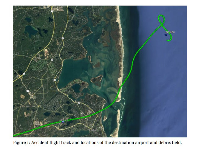
During the flight, the airplane flew at an altitude of about 8,000 ft mean sea level (msl), until it began the descent to the destination airport, Chatham Municipal Airport (CQX), Chatham, Massachusetts. At 1844, the airplane reached and maintained 1,000 ft msl, and then overflew CQX on a 080° heading. The airplane continued past the airport, turned northeast and flew over the Atlantic Ocean, then made a 270° left turn to the southeast. The airplane began a descending right turn, from about 1,025 ft msl at 18:49:26 to 675 ft msl at 18:49:33, before track data was lost. The debris field of the airplane was located on November 3, 2021, at a water depth of about 80 ft, about 2.5 miles from the Cape Cod National Seashore.
Figure 1 provides an overview of the final portion of the accident flight track, the destination airport, and the location of the debris field. The flight track is depicted in green. The destination airport is depicted by the airplane labeled CQX, and the location of the debris field is depicted by the airplane labeled N2186U.
The FAA was not providing any air traffic control services during the accident flight.
According to FAA airman records, the pilot held a private pilot certificate with a rating for airplane single-engine land. His most recent FAA third-class medical certificate was issued November 12, 2019. At that time, he reported 300 hours of total flight experience, of which 75 hours were within 6 months prior to the exam. The pilot did not hold an instrument rating.
According to FAA airworthiness records, the airplane was manufactured in 1979. It was powered by a Lycoming O-540 series engine equipped with a Hartzell propeller. Review of maintenance records revealed that the airplane’s most recent annual inspection was completed on January 14, 2021, at a total time of 3,336.4 hours on the airframe and 1,291.6 hours since major overhaul of the engine.
According to astronomical data, on the day of the accident the sunset was at 1735 and the end of civil twilight was at 1803. The moonrise was at 0150 and the moonset was at 1547. The phase of the moon was waning crescent, with 20% of the moon’s visible disk illuminated; however, at the time of the accident, the position of the moon was under the horizon.
Examination of the airframe and engine are pending recovery of the wreckage.
Aircraft and Owner/Operator Information
Aircraft Make: Piper
Registration: N2186U
Model/Series: PA-28-236
Aircraft Category: Airplane
Amateur Built:
Operator: On file
Operating Certificate(s) Held: None
Operator Designator Code:
Meteorological Information and Flight Plan
Conditions at Accident Site: VMC
Condition of Light: NightDark
Observation Facility, Elevation: CQX,68 ft msl
Observation Time: 18:52 Local
Distance from Accident Site: 6 Nautical Miles
Temperature/Dew Point: 14°C /13°C
Lowest Cloud Condition: Clear
Wind Speed/Gusts, Direction: 6 knots / , 230°
Lowest Ceiling: None
Visibility: 10 miles
Altimeter Setting: 29.63 inches Hg
Type of Flight Plan Filed: None
Departure Point: Reading, PA (RDG)
Destination: Chatham, MA (CQX)
Wreckage and Impact Information
Crew Injuries: 1 Fatal
Aircraft Damage: Destroyed
Passenger Injuries: N/A
Aircraft Fire: Unknown
Ground Injuries: N/A
Aircraft Explosion: Unknown
Total Injuries: 1 Fatal
Latitude, Longitude: 41.7544,-69.884933
Those who may have information that might be relevant to the National Transportation Safety Board (NTSB) investigation may contact them by email witness@ntsb.gov, and any friends and family who want to contact investigators about the accident should email assistance@ntsb.gov. You can also call the NTSB Response Operations Center at 844-373-9922 or 202-314-6290.

Roger Mills
~
Roger D. Mills was born in 1955 to Robert and Anna (Breitfield) Mills in Seymour, Indiana. He graduated from Seymour High School in 1973. He then went on to earn his associates degree in Electronic Engineering Technology at the ITT Technical Institute in 1975. He earned his Bachelor of Science and Business Administration in 1995 at South West University. He also earned his MBA in 2000 at Syracuse University.
Roger married Theresa Pagle in 1985 in Covington, LA. Roger and Theresa lived in several states while Roger pursued his career including New Orleans, LA, Syracuse, NY, Uxbridge, MA, Redmond, WA, and most recently in Woburn, MA, Seymour, IN, Brownstown, IN, and Abita Springs, LA. Roger retired from Hologic, Inc. in 2015 as a Senior Vice President and General Manager of Customer Service.
Roger had many interests and hobbies. He manufactured his own fireworks and loved to work in his yard. He could, literally, fix anything. Roger loved to spend time on his boat, at his lake house. He loved to travel, see new things, and spending time with his family and friends.
Roger was a member of the New England Thunderbirds and enjoyed showing his classic cars. Two of his favorites were a 2005 50th Anniversary Thunderbird and a 2006 Chevrolet SSR. Roger was an avid pilot and flew in his 28 Dakota Piper all over the country. He especially liked going on adventures with his brother, Norman.
Roger was a member of many clubs and service organizations including: Towanda Club, Woburn, MA, Seymour Elks Lodge, Seymour Moose and the Seymour Catholic Men's Club. He especially enjoyed working at the Seymour Oktoberfest for the Knights of Columbus.
Roger was flying from Indiana to Massachusetts on Sunday, October 31, 2021. His plane went down just off the coast of Massachusetts, near Cape Cod. The plane has been located but Roger's whereabouts are unknown, at this time. The reason the plane went down, is also unknown. It may have been due to a catastrophic plane failure or an unknown health issue.
Roger was an extraordinarily smart, talented, loving, funny, and fun-loving man. He will be so greatly missed by his loving wife, Theresa, his dear brother, Norman Mills, his much-loved Miniature Schnauzer, Rocky, Nieces and Nephews: Logan and Alysha Mills, Alisha (David) Gay, Ashley (Jeff) Blackwell. In addition to his family, Roger will be missed by many dear friends.
A memorial service will be held at Voss and Sons Funeral Service on Tuesday November 9, 2021, at 7 pm. Visitation will be held on Tuesday November 9, 2021, from 4-7 pm at Voss and Sons Funeral Service.
In lieu of flowers the family request donations be made to the American Cancer Society in care of Voss and Sons Funeral Service.
Massachusetts State Police
November 04, 2021
Massachusetts State Police Dive Team, Marine unit, Environmental PD, and local agencies, conducted 9 dives today off of Chatham. Divers located the fuselage of the missing plane, however, the pilot was not recovered. Todays mission followed prior dives yesterday where partial landing gear was recovered.
CHATHAM, Massachusetts —
State police divers Thursday afternoon found the wreckage of the Piper PA-28-236 Dakota that crashed into the ocean Sunday night approximately 3 miles east of Nauset Beach in Orleans.
"It's right in the area of the original position given by the Coast Guard the night of the search, 3.5 miles east of Sampson Island in about 70 to 80 feet of water," said Chatham Harbormaster Stuart Smith.
The state police said in an email statement Thursday that their dive team, working with their marine unit, environmental police and local agencies, did nine dives Thursday.
"Divers located the fuselage of the missing airplane, however, the pilot was not recovered," according to the statement.
The state police confirmed that on dives Wednesday they recovered part of the landing gear. No further dives are planned at this time.
Smith said state police and environmental police working the area late Wednesday towing side-scan sonar found an airplane wheel. They located the rest of the wreckage Thursday morning and dove on it in the afternoon, he said.
"The wreckage was scattered with the wings separated from the fuselage," Smith said.
Roger Mills of Woburn was flying from Reading, Pennsylvania
Retired medical device company executive Roger Mills, 67, of Woburn was identified by the Federal Aviation Administration as the pilot of the plane. He took off from Reading Regional Airport in Reading, Pennsylvania, on Sunday planning to arrive at Chatham Municipal Airport by 7:30 to 8:00 p.m. Sunday.
The Coast Guard received a report at 10:34 p.m. Sunday from the Air Force Regional Command Center about a possible downed Piper PA-28 aircraft off Nauset Beach. The original call to the Air Force came from a friend of the pilot who was waiting for the aircraft at the Chatham airport.
The Coast Guard said the last transponder broadcast showed the plane rapidly losing altitude. The Coast Guard discontinued its active search Tuesday morning, but local harbormasters, state and environmental police continued the search for the next two days.
The dive team worked in 3- to 4-foot rolling seas, in cold water with strong currents, Smith said. In November, Cape Cod waters still have a robust population of great white sharks.
"The environmental and state police ... they did an excellent job. Very team-oriented and professional," Smith said.
The National Transportation Safety Board opened an investigation into the crash this week. Spokesman Peter Knudson said the retrieval of the plane for inspection by his agency would be arranged and paid for by the company that insured the aircraft.
"They are responsible for making those arrangements and providing funding," he said.


descending over water. reminds me of the July 1999 crash into the Atlantic Ocean off Martha's Vineyard, Mass., piloted by John Kennedy.
ReplyDeleteLast light was 6 PM L for Hyannis, Massachusetts.
SPATIAL for N2186U.
18:38:52
Speed: 179 kt
Altitude: ▼ 3,225 ft
Vert. Rate: -640 ft/min
Track: 74.4°
Pos.: 41.624, -70.324
18:37:47 L
Speed: 177 kt
Altitude: ▼ 3,950 ft
Vert. Rate: -640 ft/min
Track: 75.3°
Pos.: 41.610, -70.393
Any flight data? Hidden of FA.
ReplyDeleteHistorical METAR shows a broken layer in that area that evening around 3500’
I take that back, the cape was clear skies, BOS had multiple scattered/broken layers
Deleteflight data..
Deletehttps://globe.adsbexchange.com/?icao=a1da77&lat=41.624&lon=-70.324&zoom=10.9&showTrace=2021-10-31&trackLabels
Very sad, a fairly new private pilot and airplane owner. The globe.adsbexchange.com data has him flying directly towards Chatham but the last radar return of 3.5 miles east of Nauset beach is no where close to a normal VFR approach from the west. He wasn't instrument rated but was he trying to use the RNAV approach and succumbed to dark night spatial disorientation?
ReplyDeleteads-b data summary
ReplyDeleterecent History N2186U
depart 42.587,-70.971 @ Beverly Muni, Mass 2021-10-18.
stop 40.623,-79.006 @ Indiana County Jimmy Stewart.
land 38.958,-85.835 Freeman Muni Airport, IN 10-18
flights in mid-west 10-23
land 10-27 Freeman Muni Airport, IN.
depart 10-31 Freeman Muni Airport, IN. 12:52 L
land 40.386,-75.982 Reading Muni, PA. 16:22 L, then depart 16:55 L.
last return: 18:38:52 L
Speed: 179 kt
Altitude: ▼ 3,225 ft
Vert. Rate: -640 ft/min
Track: 74.4°
Pos.: 41.624,-70.324
sunset was 17:35 L, and last light 18:00 L.
Nauset Beach coast and beyond is the Atlantic Ocean.
ReplyDelete"The Coast Guard reported that the last transponder signal from the plane came from a location 3½ miles due east of Nauset Beach"
It is odd that the plane appeared to overshoot Chatham. Someone else pointed out to me that the pilot-controlled lighting for Chatham’s runway is on a different frequency than the CTAF/voice frequency used to make position reports for the airport - query whether the pilot arrived at the airport but couldn’t turn on the runway lights and had some accident trying to cope with that issue.
ReplyDeleteHe sure had a long flight that day. Could he have forgotten or not read that the PCL at CQX was on 122.95 and not 122.8, missed the dark airport altogether, then got SD while trying to turn over water in the darkness?
ReplyDeleteI am a friend and not a pilot. Any expiation for the rapid descent, reported at 400 ft? thanks
ReplyDeletecorrection, he was descending
Deleteat 4000tf/