
The National Transportation Safety Board traveled to the scene of this accident.
Additional Participating Entities:
Federal Aviation Administration / Flight Standards District Office; Scottsdale, Arizona
Federal Aviation Administration / Flight Standards District Office; Phoenix, Arizona
Robinson Helicopter Company; Torrance, California
Delta Leasing Inc
Quantum Helicopters


Flight Operations Academy LLC
Location: Chandler, Arizona
Accident Number: WPR22FA001
Date and Time: October 1, 2021, 07:40 Local
Registration: N412TL (A1); N2868H (A2)
Aircraft: ROBINSON HELICOPTER COMPANY R22 (A1); Piper PA-28-181 (A2)
Injuries: 2 Fatal (A1); 2 None (A2)
Flight Conducted Under:
Part 91: General aviation - Instructional (A1); Part 91: General aviation - Instructional (A2)
On October 1, 2021, about 0740 mountain standard time, a Piper PA-28-181 airplane, N2868H, and a Robinson R22 helicopter, N412TL, were involved in a midair collision near Chandler, Arizona. The airplane sustained minor damage and the helicopter was destroyed. The flight instructor and student pilot of N2868H, were not injured. The flight instructor and student pilot of N412TL, were fatally injured. Both aircraft were operated as Title 14 Code of Federal Regulations Part 91 instructional flights.
Both aircraft were in parallel traffic patterns at Chandler Municipal Airport (CHD), and a review of recorded communications revealed that both aircraft were in contact with air traffic control tower personnel. The airplane was operating in a closed right traffic pattern for runway 4R and had been cleared to land. The helicopter was operating in a closed right traffic pattern for Taxiway C and had been “cleared for the option.” Shortly after the airplane turned final for Runway 4R, the airplane flight instructor radioed the tower and reported that they felt and heard a loud bang. The flight instructor believed they might have struck birds, advised the tower, and declared an emergency. He requested that tower look at the landing gear. Tower personnel confirmed they had 3 landing gear extended and again cleared them to land.
During the landing flare, the flight instructor noticed the left wing continued to descend. He utilized aileron inputs to keep the wing up. After the airplane touched down, it veered left and exited the runway before it came to rest in the infield between runway 04R and 04L.
During the same timeframe, witnesses reported a downed helicopter in the vicinity of the Chandler Airport. Shortly after, first responders identified the wreckage of N412TL. The helicopter impacted terrain about .5 mile southwest of the approach end of runway 04R. A postcrash fire ensued.
Recorded Automatic Dependent Surveillance-Broadcast (ADS-B) data provided by the Federal Aviation Administration (FAA) showed that the accident aircraft were operating in VFR traffic patterns at CHD. Both aircraft appeared to be on a base to final turn with the airplane making an approach to runway 04R and the helicopter making an approach to taxiway C (parallel to and to the right of runway 04R). The
data showed both aircrafts’ flight paths intersected about 0740:15 at an altitude of about 1,400 ft mean sea level (msl) as seen in figure 1.
Both aircraft were recovered and secured in a storage facility pending further examination.
Aircraft and Owner/Operator Information (A1)
Aircraft Make: ROBINSON HELICOPTER COMPANY
Registration: N412TL
Model/Series: R22
Aircraft Category: Helicopter
Amateur Built:
Operator:
Operating Certificate(s) Held: Pilot school (141)
Operator Designator Code:
Aircraft and Owner/Operator Information (A2)
Aircraft Make: Piper
Registration: N2868H
Model/Series: PA-28-181
Aircraft Category: Airplane
Amateur Built:
Operator:
Operating Certificate(s) Held: None
Operator Designator Code:
Meteorological Information and Flight Plan
Conditions at Accident Site: VMC
Condition of Light: Day
Observation Facility, Elevation: KCHD,1243 ft msl
Observation Time: 06:47 Local
Distance from Accident Site: 0 Nautical Miles
Temperature/Dew Point: 20°C /9°C
Lowest Cloud Condition: Clear
Wind Speed/Gusts, Direction: 4 knots / , 40°
Lowest Ceiling: None
Visibility: 10 miles
Altimeter Setting: 30 inches Hg
Type of Flight Plan Filed:
Departure Point:
Destination:
Wreckage and Impact Information (A1)
Crew Injuries: 2 Fatal
Aircraft Damage: Substantial
Passenger Injuries:
Aircraft Fire: On-ground
Ground Injuries:
Aircraft Explosion: None
Total Injuries: 2 Fatal
Latitude, Longitude: 33.269096,-111.81112 (est)
Wreckage and Impact Information (A2)
Crew Injuries: 2 None
Aircraft Damage: Minor
Passenger Injuries:
Aircraft Fire: None
Ground Injuries:
Aircraft Explosion: None
Total Injuries: 2 None
Latitude, Longitude: 33.269096,-111.81112 (est)
Those who may have information that might be relevant to the National Transportation Safety Board (NTSB) investigation may contact them by email witness@ntsb.gov, and any friends and family who want to contact investigators about the accident should email assistance@ntsb.gov. You can also call the NTSB Response Operations Center at 844-373-9922 or 202-314-6290.
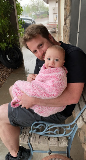
Michael Papendick captured with daughter.
CHANDLER, Arizona — There are many unknowns surrounding the mid-air collision between a plane and a helicopter in Chandler, which took the lives of two people. The family of 34-year-old Mike Papendick wants people to know about their loving husband and father.
Papendick leaves behind his wife Becca and their 11-month-old daughter Aubrey.
"I just wanna know what happened during his last few moments," says Becca Papendick, Mike's wife.
The family recently moved back to Phoenix to start a new chapter of their life together. Mike just got out of the Navy after serving for seven years. He had hoped to turn his passion for flying, into a career.
"He wanted to fly for the police or EMS and then do some tours in Hawaii and all that fun stuff. He had the adrenaline of being in the sky," says Papendick.
Mike began the Quantum Helicopters flight school program at the end of August. Since then, Becca says he had gone up several times with an instructor. There are many unknowns, though, as to what went wrong Friday morning.
"From what I understand, he was about to land. They, he and Jess, were about to land. They were almost done with their flight," says Papendick.
Mike and the instructor passed away after Chandler Fire officials say a fixed-wing plane collided with their helicopter. The plane landed safely near the runway at Chandler Airport; the helicopter crashed and caught fire.
"I was not expecting to wake up to this news today. I didn't know, I didn't know this morning was going to be how it was. I didn't know I would be saying bye," says Papendick.
Becca is now leaning on her family for support. They are standing by her side, hurting just as much.
"She's going through a unique set of challenges; most people never go through in their entire lives," says Rachel Lima, Becca's sister.
Her sister Rachel has started an online fundraiser as a way to help during this sudden and unexpected time.
She is also trying to lift Becca's spirits, pointing out the beautiful moments they have shared, like the first time they met.
"We were pen-pals, but we were coworkers at first. He saw me at massage school but I didn't see him, like we were in the lunchroom and he had recognized me and then when I had my interview at Massage Envy, he was like 'there she is; there she is,'" says Becca.
They have been together ever since, nearly 5 years. They have built a family together with almost one-year-old Aubrey.
Now, Becca is holding onto that as they move forward with Mike in their hearts.
The crash investigation is still in the early stages.
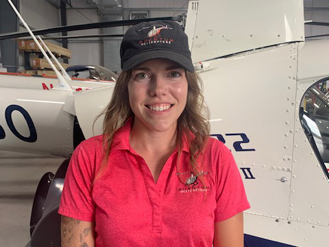
Jessica Brandal, CFII
~
CHANDLER, Arizona — Authorities have identified the two people killed last week when a helicopter collided midair with a single-engine airplane outside a suburban Phoenix airport.
The Chandler Police Department said Thursday that 34-year-old Michael Papendick and 27-year-old Jessica Brandal died at the scene by Chandler Municipal Airport last Friday.
Police are not releasing the names of the two people who were on the plane, but neither was injured at the scene near McQueen and Queen Creek roads.
The Chandler Fire Department received reports of a fire in a brush field next to the airport that morning. Crews discovered the helicopter’s burning wreckage and were able to put the fire out quickly.
The National Transportation Safety Board and the Federal Aviation Administration continue to investigate the incident.
The chopper was operated by Quantum Helicopters and the plane by Flight Operations Academy. Both are flight schools, according to police. The owner of Flight Operations Academy had said a flight instructor and student were in the plane.
Chandler Municipal Airport is considered one of the nation’s 50 busiest general aviation airports with more than 200,000 flight operations a year, according to the East Valley city’s tourism office.


Towered airport. Will be curious to see if the collision was / "in the vicinity of" means within Delta airspace.
ReplyDeleteTrack shows the Archer looping the pattern in touch and go's, but shortening the downwind leg to get landed at the end. Will have to see the R22 track to know if the shortened downwind was a response to or led to the collision.
DeleteExample R22 DC3 school tracks show flights typically finish with returns inbound to KCHD from the south at mid-field. Pattern altitudes provide vertical separation.
Airnav shows: Pattern altitude: 2300.4 ft. MSL, FIXED WING - 2300 FT MSL. ROTORWING - 1900 FT MSL.
Archer's track:
https://globe.adsbexchange.com/?icao=a2e7bd&lat=33.263&lon=-111.833&zoom=12.8&showTrace=2021-10-01&trackLabels×tamp=1633099177
(Flightaware's Archer track has a spurious diagonal glitch):
https://flightaware.com/live/flight/N2868H/history/20211001/1413Z/KCHD/KCHD
R22 N3082C example track:
https://flightaware.com/live/flight/N3082C/history/20211001/1459Z/KCHD/KCHD
R22 N7193U example track:
https://flightaware.com/live/flight/N7193U/history/20211001/1504Z/KCHD/KCHD
On LiveAtc after about the 16 minute mark, you can hear the tower controller telling 68 Hotel that there would be a delay in the fire crew reaching them because "a helicopter went down as well, not sure if it was a flock of birds or what happened, but the fire crew is having to look at that as a bigger issue".
DeleteIt doesn't sound like 68H had any fire. The controller tells an inbound aircraft that they were closing the airport for the helicopter crash and an aircraft going off runway four right (which was the Archer, 68H).
https://archive.liveatc.net/kchd/KCHD-Twr1-Oct-01-2021-1430Z.mp3
Switching between the R22 and Archer tracks linked below as overlays reveals that the two paths intersected at approximately 14:40:18Z as the Archer was completing the turn to final from the shortened downwind leg.
DeleteR22 N412TL's Track:
https://globe.adsbexchange.com/?icao=a4dd42&lat=33.264&lon=-111.818&zoom=14.6&showTrace=2021-10-01&leg=8&trackLabels
Archer N2868H's track:
https://globe.adsbexchange.com/?icao=a2e7bd&lat=33.264&lon=-111.818&zoom=14.6&showTrace=2021-10-01&trackLabels
Zooming in on last three data points of R22 N412TL's track and looking at times and vertical rates:
Delete14:40:14Z 1300'MSL 61Knots -384'/min
14:40:16Z 1300'MSL 45Knots -1408'/min
14:40:18Z 1200'MSL 46Knots -3968 ft/min
https://globe.adsbexchange.com/?icao=a4dd42&lat=33.261&lon=-111.818&zoom=19.5&showTrace=2021-10-01&leg=8&trackLabels×tamp=1633099206
There is no reason to switch between two overlays when you can easily include both tracks on ONE page. Here is the exact moment of collision showing the tracks of BOTH aircraft: https://globe.adsbexchange.com/?icao=a4dd42,a2e7bd&lat=33.262&lon=-111.821&zoom=16.3&showTrace=2021-10-01&trackLabels×tamp=1633099216
DeleteIf you are going to post a link to ADSBX, please learn how to use it properly.
Okay Sheldon. Your ADSBX link showing both aircraft on one page includes R22 N412TL legs one thru six from hours earlier that the accident pilot didn't fly.
DeleteHere is that same link, corrected to drop out earlier N412TL legs and isolate the R22's leg #8 accident pass:
https://globe.adsbexchange.com/?icao=a4dd42,a2e7bd&lat=33.262&lon=-111.821&zoom=16.3&showTrace=2021-10-01&leg=8,1&trackLabels×tamp=1633099216
Inserting the URL modifier "&leg=8,1" is all it takes to isolate the N412TL leg #8 accident pass. You should follow your own advice and learn how to use ADSBX properly to avoid further embarrassment.
Towered still means see and avoid. Especially within Delta airspace.
ReplyDeleteSee and avoid? What does that mean?? After 10,000 hours of dual given, I can't believe I'd never heard that before. Can you explain it? And thanks for the terrific insight!
DeleteI was wondering if a controller was involved or not, not "who should we blame."
Uh, 10k hours of dual given and you've never read FAA circular AC 90-48D?
DeleteIf you were wondering if a controller was involved, you could probably just look up KCHD in the former AF/D for class D operating hours.
Seeing how the Robinson impacted the shrubs at the end of the airport property, its likely they were inside the delta. (?;
Part 91, § 91.113 is also particularly insightful.
Delete"who should we blame"?? The two PICs. It was VFR. FAA Pilots’ Role in Collision Avoidance pursuant to AC 90-48D section 4.1 “See-and-Avoid Concept” means you see with your eyes and avoid. This was Class D, not C or B.
DeleteAppears N2868H was conducting touch and goes on Rwy 4R (4870 x 75 ft.) Last recorded ADS-B signal "UTC Day 2021-10-01, Time: 10:40:43, Speed: 53 kt, Altitude: ▼ 900 ft., Vert. Rate: -1280 ft/min, Track: 49.6°, Pos.:33.268°, -111.811°" reportedly "landed safely on the runway with a damaged landing gear," thus impacted R22 on final to 4R.
ReplyDeleteTangling with helicopter Ops while you're operating on Runway 4 right at Chandler is always a bit sketchy. The helipad is at the departure end of that runway to the east and the helicopters come up from the south and run parallel to the runway at a lower altitude than the fixed-wing aircraft. They generally only bring planes in on 04 right if they're staying in the pattern. Most of us come in on 04 left if it's a regular approach. I always have my head on a swivel whenever I'm coming in for 04 right for whatever reason.
ReplyDeleteThe helicopters are essentially running against the pattern but at a lower altitude for that runway.
LiveATC audio for N & S towers:
ReplyDeletehttps://archive.liveatc.net/kchd/KCHD-Twr1-Oct-01-2021-1430Z.mp3
https://archive.liveatc.net/kchd/KCHD-Twr2-Oct-01-2021-1430Z.mp3
Flew a few times in that area and airports (Ak-Chin, Casa Grande, Chandler) and about the most intense and busy airspace due to non stop training by multiple flight schools. Students everywhere and anywhere. Even as a warning on the sectional.
ReplyDeleteF70 i.e French Valley airport is another one where a question isn't an IF but a WHEN it will happen but seems a tower isn't a cure.
Generally helis are mostly doing pattern work "so as to avoid fixed wing traffic" per the regs.
There was another accident similar to this one in KCLW in 2017 but everyone survived there. Here the archer had 2 people onboard and probably a CFI was one of them and even with 2 pairs of eyes the R22 was collided with so shows they are a pretty small target for see and avoid.
FAR 91.129 Operations in Class D airspace. (f) Approaches (2) "Avoid the flow of fixed-wing aircraft, if operating a helicopter." Comply with all other requirements such as communication requirements with the tower.
ReplyDeleteFAR 91.126 Operating on or in the vicinity of an airport in Class G airspace. (b) Direction of turns. (2) "Each pilot of a helicopter or powered parachute must avoid the flow of fixed-wing aircraft."
Yeah, I'm not totally sure why the R22 was flying a "traditional" pattern.
DeleteTypically, the Quantum folks fly up and down the Charlie taxiway, entering mid-field from the south.
I am not rotor-proficient, so I don't know what is required for the training.
In non towered airports the helis generally will do a different pattern from fixed wings (i.e right turns if the fixed wing pattern is to the left) and target taxiways as final if possible, so stay as separated. But here one can only speculate that the tower told both aircrafts to do a specific pattern. Nonetheless the PIC for both have a duty for see and avoid and the buck basically stop there per CFR 14 Part 91, regardless of what the tower told them to do.
DeleteGiven the rules of priority in 14 CFR 91.113 this would most likely apply here:
"(g) Landing. Aircraft, while on final approach to land or while landing, have the right-of-way over other aircraft in flight or operating on the surface, except that they shall not take advantage of this rule to force an aircraft off the runway surface which has already landed and is attempting to make way for an aircraft on final approach. When two or more aircraft are approaching an airport for the purpose of landing, the aircraft at the lower altitude has the right-of-way, but it shall not take advantage of this rule to cut in front of another which is on final approach to land or to overtake that aircraft."
The tower controller relied on the Archer to fly a track outside of the track the R22 would fly. For six 4R orbits, the Archer's path could not have crossed the R22's path.
DeleteThe R22 was aligning for the taxiway, as seen in the Adsbexchange track. There was no reason for the Archer to end up crossing or being directly above the R22's track at any point in the pattern if the Archer had not deviated from the larger pattern circuit it was supposed to maintain.
was likely practicing a power-off 180. a perfectly reasonable explanation for a shorter pattern. "larger pattern it was supposed to maintain" who told them they had to maintain a large pattern?
DeleteUnfortunately, the Archer pilots did not maintain awareness of the R22's position as the helicopter continued on it's second loop around the pattern traveling in the same direction below the Archer.
ReplyDeleteLosing track of the R22 became a problem when the Archer pilots abruptly ended the downwind leg and executed that shortened approach move that started while the R22 was hidden below the wing.
Was N2868H ending their instructional session, departure was @ 06:43 !
Delete@ 39:18 PIC initiated from 2,200 ft a right base, clearly short of all multiple previous right turns onto base. On this last go around, appears to have maintained pattern altitude until abeam approach end of 4R, then started right turn unto base. In conclusion, fatal loss of attention and situational awareness.
ADS-B records a shortened 45 second downwind from previous 68H 'loops'!
DeleteCommenters on another forum suggested that the shortened downwind move was a simulated engine out practice. Haven't been able to determine from listening to LiveAtc whether the maneuver was coordinated with the Controller or just done spontaneously.
DeleteFound another day's looping run where the Archer made the shortened downwind return:
https://globe.adsbexchange.com/?icao=a2e7bd&lat=33.276&lon=-111.828&zoom=13.0&showTrace=2021-09-01&trackLabels
There have been 3 fatal mid-air collisions involving R-22's at control tower airports. Helicopter pilots need to learn that sometimes you have to tell a controller, "Unable." If they question why, simply say, "Because I'm in the seat that's moving."
ReplyDeleteUnable to do what, in this circumstance?
Deletefrom the r22's perspective they couldn't have seen the archer descend upon them as they were directly below the archer. The only way they could have noticed the danger was if they were watching adsb
Delete...or the shadows on the ground.
DeleteAnd how exactly does that play here when a low fixed wing does not see the convergence on final to a runway that was cleared #2 ?
ReplyDeleteThe low fixed wing was told that there were 2 helicopters operating in the taxiway Charlie pattern. The low fixed wing acknowledged there were 2 helicopters operating in the taxiway Charlie pattern. Then the low fixed wing chose to fly directly through the Charlie pattern and one of those helicopters.
DeleteThe R22 made two trips around the pattern, was hit on the second. Was not lining up for the first T&G, was lining up for the second one.
DeleteNote the time tags in the two consecutive R22 passes:
First pass:
https://globe.adsbexchange.com/?icao=a4dd42&lat=33.260&lon=-111.824&zoom=13.4&showTrace=2021-10-01&leg=7&trackLabels
Second pass:
https://globe.adsbexchange.com/?icao=a4dd42&lat=33.260&lon=-111.824&zoom=13.4&showTrace=2021-10-01&leg=8&trackLabels
Preliminary report is out. Nothing in the report to explain the Archer's shortened approach.
ReplyDeletehttps://data.ntsb.gov/carol-repgen/api/Aviation/ReportMain/GenerateNewestReport/104018/pdf
I agree that it looks to be and emergency landing practice. If it is true that tower informed the Archer of helicopter traffic in the pattern then it would seem wise not to execute such a maneuver.
ReplyDeleteThe other interesting observation - I noticed when the Archer came to rest off runway it was reporting 900 feet pressure altitude? This brings to question what altitude is being observed by the tower? Pressure Altitude or GPS Altitude? I understand that ADS-B out has both in its data stream? I have heard that there is a problem with pressure altitude accuracy. Seems like if pressure altitude and GPS indications are not within tolerance aircraft should be not working a pattern.
I wonder if a smart software algorithm monitoring GPS position w/altitude in the tower would be able to detect and announce an impending collision - thus helping controllers provide safer flight operations in the pattern... or would constant alerts drive them crazy! Depends on the quality of the algorithm?
A sad loss of life for two people. My condolences to their friends and family.
Jessica was my daughter. I cannot understand how this happened. It is unreal to me. How could this happen? I will never heal.
ReplyDeleteJessica was my daughter. I cannot understand how this happened. It is unreal to me. How could this happen? I will never heal.
ReplyDeleteJessica was my daughter. I cannot understand how this happened. It is unreal to me. How could this happen? I will never heal.
ReplyDeleteI hope you are able to find some peace.
Delete