
The National Transportation Safety Board traveled to the scene of this accident.
Additional Participating Entities:
Federal Aviation Administration / Flight Standards District Office; Atlanta, Georgia
Piper Aircraft; Vero Beach, Florida
Lycoming Engines; Williamsport, Pennsylvania
Location: Blairsville, GA
Accident Number: ERA22FA014
Date & Time: October 13, 2021, 08:16 Local
Registration: N9126P
Aircraft: Piper PA-24-260
Injuries: 1 Fatal
Flight Conducted Under: Part 91: General aviation - Personal
On October 13, 2021, about 0816 eastern daylight time, a Piper PA-24-260, N9126P, was destroyed when it was involved in an accident near Blairsville, Georgia. The private pilot was fatally injured. The airplane was operated as a Title 14 Code of Federal Regulations Part 91 personal flight.
The instrument-rated pilot, who owned the airplane, filed an instrument flight rules flight plan from Blairsville Airport (DZJ) to Sebring Regional Airport (SEF), Sebring, Florida. According to preliminary Automatic Dependent Surveillance – Broadcast (ADS-B) data, the pilot took off on runway 8 about 0815 and immediately commenced a left turn to the northwest to a heading of about 300° at which point the airplane began a right turn before the ADS-B data ended. The airplane impacted trees and terrain on a heading of 090° about 1.5 nautical miles north of the departure end of runway 8.
Takeoff minimums and obstacle departure procedures for DZJ (an uncontrolled airport) required pilots to climb in visual conditions to cross the airport at or above 4,500 ft msl before proceeding on course. Weather minimums for the climb in visual conditions were 2,700 ft ceiling and 3 miles visibility. The DZJ weather at 0815 included a ceiling of 200 ft overcast with ¼ mile visibility in fog. Witnesses and first responders reported heavy fog conditions at the accident site.
Initial examination of the accident site and wreckage revealed that all major structural components of the airplane were accounted for. The airplane struck trees before colliding with terrain on the banks of Nottely Lake. The measured descent angle from the tree breaks to the initial impact crater was 22°.
The wreckage was retained for further examination.
Aircraft and Owner/Operator Information
Aircraft Make: Piper
Registration: N9126P
Model/Series: PA-24-260
Aircraft Category: Airplane
Amateur Built:
Operator: On file
Operating Certificate(s) Held: None
Operator Designator Code:
Meteorological Information and Flight Plan
Conditions at Accident Site: IMC
Condition of Light: Day
Observation Facility, Elevation: KDZJ,1909 ft msl
Observation Time: 08:15 Local
Distance from Accident Site: 2 Nautical Miles
Temperature/Dew Point: 14°C /14°C
Lowest Cloud Condition:
Wind Speed/Gusts, Direction: 3 knots / , 100°
Lowest Ceiling: Overcast / 200 ft AGL
Visibility: 0.25 miles
Altimeter Setting: 30.16 inches Hg
Type of Flight Plan Filed: IFR
Departure Point: Blairsville, GA
Destination: Sebring, FL (SEF)
Wreckage and Impact Information
Crew Injuries: 1 Fatal
Aircraft Damage: Destroyed
Passenger Injuries:
Aircraft Fire: None
Ground Injuries:
Aircraft Explosion: None
Total Injuries: 1 Fatal
Latitude, Longitude: 34.88107,-83.99402 (est)
Those who may have information that might be relevant to the National Transportation Safety Board (NTSB) investigation may contact them by email witness@ntsb.gov, and any friends and family who want to contact investigators about the accident should email assistance@ntsb.gov. You can also call the NTSB Response Operations Center at 844-373-9922 or 202-314-6290.
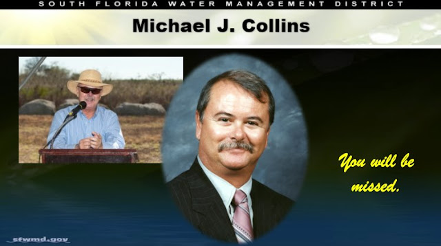
Michael J. Collins
Collins was 71 years old and is survived by his wife, Kym.
Michael Collins, a former South Florida Water Management District (SFWMD) Governing Board member, has died after his plane crashed Wednesday morning in Georgia.
Collins took off in heavy fog to head back to Florida and was the only person on board. Police say the plane clipped several trees on its way down before crashing, though authorities have not yet directly tied the foggy conditions to the crash.
Former Gov. Jeb Bush appointed Collins to the SFWMD Governing Board, which helps set water policy in 16 counties across the southern portion of Florida. Collins was sworn in as a member in 1999 and served on the body for just over a decade.
After his time with the water district, Collins created the Water Resources Advisory Council (WRAC) to help guide the water management district on water issues and increase public participation in the policy decision-making process. Collins remained active in water policy discussions in the years after he left the SFWMD Governing Board, writing several pieces responding to ongoing policy debates.
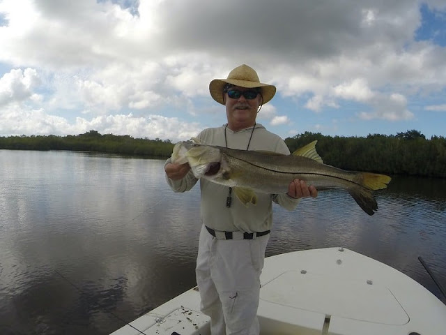
Collins was also a former Wall Street banker who then worked as a fishing guide in Islamorada and led the Florida Keys Fishing Guides Association.
Additional reporting on the crash from North Georgia News says Collins flew from Florida Tuesday into the Blairsville Municipal Airport. Collins hails from Islamorada in the Keys, though he also owned a home in Morganton, Georgia, near Georgia’s northern border.
Collins was flying near Lake Nottely on his way home to Florida when the plane went down, according to the Union County Sheriff’s Office. Multiple witnesses say they heard the crash before calling it in shortly after 8 a.m.
The National Transportation Safety Board is investigating the precise cause of the crash.
Collins was 71 years old. He is survived by his wife, Kym.
Michael J. Collins, 71, has been identified as the pilot who died in the Oct. 13 morning plane crash on the shores of Lake Nottely, according to the Union County Sheriff’s Office.
Next of kin have been notified.
Collins is from Islamorada, Florida, and owns a home in Morganton, where he had been staying for the summer.
He had just taken off from the Blairsville Municipal Airport on a business trip to Florida when the crash occurred, roughly a quarter after 8 a.m. Wednesday about 2 miles north of the airport, according to the Sheriff’s Office.
Multiple witnesses reported hearing the crash, including a homebuilder inside The Grove at Highland Park who was working outside at the time, according to the Sheriff’s Office.
The homebuilder said the plane flew directly over his position, and though it was too foggy for him to see the accident, he heard the plane’s engine sputtering before it impacted several trees and then the bank of a nearby cove on Lake Nottely, according to the Sheriff’s Office.
Witnesses called the accident in to 911 at 8:17 a.m., not long after sunrise.
A heavy fog blanketed Blairsville that morning, though it is too early to say what role, if any, the fog played in the accident, especially considering witness reports that the airplane appeared to be experiencing some sort of mechanical issue immediately preceding the crash.
The cause of the crash is currently being investigated by the National Transportation Safety Board.


Took off in heavy fog.
ReplyDeleteI did some instrument training in actual IMC a few decades ago. Back then minimums were 500' and I think we had 600' that day but time has a way of blurring those kinds of details. It's no small matter to take off into dense fog. RIP to the pilot and condolences to his family.
ReplyDeleteThe Blairsville area is smack in the middle of the north GA Blue Ridge mountains in a valley and nestled between mountain tops of 2500-3000' MSL. The Blairsville airport is surrounded by rising terrain in all directions that requires careful attention even in VFR conditions. I wouldn't take much faith in witness statements claiming mechanical problems. Few witnesses are qualified to make that judgement (and zero non-pilot, non-A&P ones), especially from an aircraft they can only hear and not see.
ReplyDeleteThe crash after takeoff from Blairsville Municipal KDZJ's field elevation of 1,907' MSL ended up on the banks of 1,779' MSL elevation Notalee Lake just two miles to the north. The aircraft overflew The Grove at Highland Park development in the final moments.
DeleteReview of the area topography between takeoff and the mapped crash vicinity doesn't find rising terrain.
Location of The Grove at Highland Park:
https://www.google.com/maps/place/The+Grove+@+Highland+Park/@34.8808103,-83.9989852,626m/data=!3m2!1e3!4b1!4m5!3m4!1s0x885f176a723e44e9:0x49db7680512320ec!8m2!3d34.8808103!4d-83.9967965!5m1!1e4
Topomap (move/zoom as required):
https://www.topozone.com/georgia/union-ga/city/blairsville/
13 flights in/out of DZJ Blairsville, GA since 16 July, likely many more in the past! 26P Registration "20-Jul-2007 MIKE COLLINS & ASSOCIATES."
ReplyDelete