
This is preliminary information, subject to change, and may contain errors. Any errors in this report will be corrected when the final report has been completed.
The National Transportation Safety Board traveled to the scene of this accident.
Additional Participating Entities:
Those who may have information that might be relevant to the National Transportation Safety Board (NTSB) investigation may contact them by email witness@ntsb.gov, and any friends and family who want to contact investigators about the accident should email assistance@ntsb.gov. You can also call the NTSB Response Operations Center at 844-373-9922 or 202-314-6290.
Federal Aviation Administration / Flight Standards District Office; Salt Lake City, Utah
Textron Aviation; Wichita, Kansas
Cannon Oil & Gas Well Services Inc
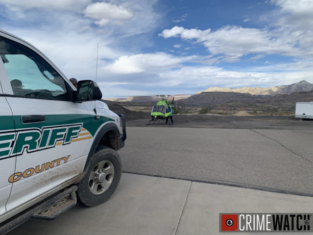
Location: Mesa, Colorado
Accident Number: CEN22FA011
Date and Time: October 11, 2021, 08:57 Local
Registration: N6748V
Aircraft: Beech 58TC Injuries: 1 Fatal
Flight Conducted Under: Part 91: General aviation - Personal
On October 11, 2021, at 0857 mountain daylight time, a Beech 58TC airplane, N6748V, was destroyed when it was involved in an accident near Mesa, Colorado. The pilot was fatally injured. The airplane was operated as a Title 14 Code of Federal Regulations Part 91 personal flight.
Fixed Base Operator (FBO) employees at Blake Field Airport (AJZ), Delta, Colorado, stated that before departure the pilot fueled the airplane with 100 gallons of aviation gasoline. The airplane taxied away from the fuel pump at 0839 and proceeded to runway 03. The airplane departed about 0843 and proceeded northeast toward its destination, Southwest Wyoming Regional Airport (RKS), Rock Springs, Wyoming. They also stated that this was the airplane’s first flight after an annual inspection had been completed on October 1, 2021.
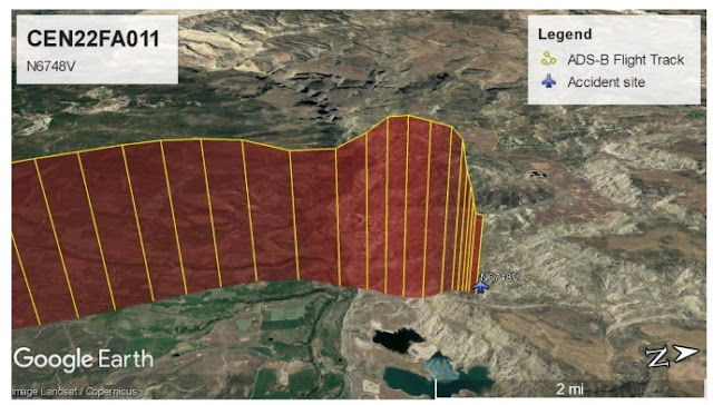
Automatic Dependent Surveillance-Broadcast (ADS-B) data revealed that about 0846 the airplane departed from runway 03 and proceeded northeast for about 4 nautical miles (nm), then turned left to north-northwest and climbed over Grand Mesa. After crossing over Grand Mesa, the airplane reached about 14,000 ft mean sea level (msl). At 0855:51 the airplane turned right and descended about 1,000 ft, then climbed to 15,000 ft. At 0856:26 the airplane descended rapidly toward terrain.
A summary of air traffic control (ATC) communications revealed that pilot was in contact with ATC and at 0852 he reported climbing through 11,000 ft for 14,000 ft. At 0857:00 the controller asked the pilot, “did you get an updraft, mountain wave out there? I’m showing you 800 ft high.” There were no other communications from the pilot.
A review of the meteorological information revealed the potential for light to moderate turbulence and mountain wave activity near the accident site. National Weather Service had no active AIRMET, SIGMET, Convective SIGMET, or Center Weather Advisory, for the route of flight.
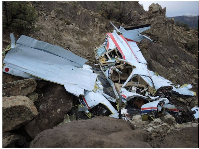
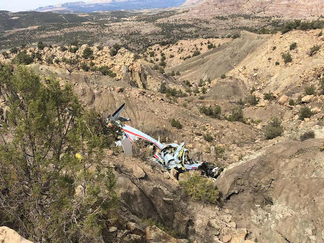
The airplane impacted a rocky mountainside and remained upright on a heading of about 040°. The wreckage debris path was about 30 ft long and mostly consisted of paint chips, shards of windscreen, various small debris and a large outboard section of the right wing that had separated on impact. The empennage was distorted to the left and remained partially attached to the rear fuselage. The bottom of the airplane exhibited impact damage and scoring from the rocky terrain. The left engine was mostly separated from the left wing nacelle, while the right engine remained attached to the right wing nacelle. The six propeller blades were relatively undamaged and did not exhibit leading edge damage or scoring.
The airplane has been retained for further examination.
Aircraft and Owner/Operator Information
Aircraft Make: Beech
Registration: N6748V
Model/Series: 58TC
Aircraft Category: Airplane
Amateur Built:
Operator: On file
Operating Certificate(s) Held: None
Operator Designator Code:
Meteorological Information and Flight Plan
Conditions at Accident Site: VMC
Condition of Light: Day
Observation Facility, Elevation: KGJT,4839 ft msl
Observation Time: 08:53 Local
Distance from Accident Site: 20 Nautical Miles
Temperature/Dew Point: 8°C /1°C
Lowest Cloud Condition: Clear
Wind Speed/Gusts, Direction: 15 knots / , 100°
Lowest Ceiling: None
Visibility: 10 miles
Altimeter Setting: 29.83 inches Hg
Type of Flight Plan Filed: IFR
Departure Point: Delta, CO (AJZ)
Destination: Rock Springs, WY (RKS)
Wreckage and Impact Information
Crew Injuries: 1 Fatal
Aircraft Damage: Destroyed
Passenger Injuries:
Aircraft Fire: None
Ground Injuries: N/A
Aircraft Explosion: None
Total Injuries: 1 Fatal
Latitude, Longitude: 39.206496,-108.12369
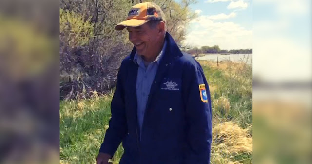
Robert Dale Cannon
(October 2, 1953 – October 11, 2021)
Robert “Rob” Dale Cannon was born October 2, 1953 to Edward and Eileen Cannon. Rob was raised in Kimball, Nebraska and is still known for his athletic achievements.
Rob moved to Wyoming in the mid 1970s and started what would become the very successful Cannon Oil & Gas Well Service, Inc., which still operates today. Rob met his perfect match and love of his life, Elaine, in 1977 and they married on December 23, 1978.
Rob and Elaine lived in Green River, WY where they raised their four children, Heather, Andrea, Alesha, and Edward (Bubba). Rob and Elaine have been blessed with 10 grandchildren.
Rob also founded and operated Rocky Mountain Testers as well as Cedar Rentals and Cannon Farms, which also continue to operate. Rob and Elaine recently built Cannon Xpress Carwash with their son, Bubba, and Rob was excited about the future of this new endeavor.
Rob was very passionate about conservation and dug many ponds and easily planted upwards of 100,000 trees over the years. Rob was an avid golfer and hunter, which he enjoyed and shared with not only family and friends but also with veterans who he always felt so honored and humbled to support and serve.
Rob earned his pilot’s license in 1975 and was a skilled and highly trained pilot, he had a true passion for flying. Rob truly believed in God, family, country and always focused on the needs of others. He was a true patriarch in every sense. Rob had an unshakable faith in Jesus Christ and impacted countless lives with his gravitating personality.
While Rob was taken too soon his legacy will continue to live on through the numerous people who cherish him.
Rob is survived by his beloved wife, Elaine; his children Heather (Jason), Andrea (Joey), Alesha (Ryan), and Bubba (Jordan); his mother, Eileen; his grandchildren Cannon, Olsen, Hudson, Easton, Truman, Rowan, Ben, Aiden, Robbie, Ryker and Harlowe. Rob also leaves behind several extended family members and many close friends he loved as family.
Rob was incredibly generous to many and would only wish to carry this forward so in lieu of flowers, please consider donating to boystown.org or littlesistersofthepoor.org in his memory.
A rosary will be held on Friday evening and a funeral mass on Saturday, October 23 at 10:00 am at St. Elizabeth’s Catholic Church in Oshkosh, NE.
The Mesa County Coroner’s Office has identified the pilot and sole occupant of a plane that crashed northeast of Mesa on Monday morning.
Robert Cannon, 68, of Rock Springs, Wyoming, was killed in the crash, according to a Coroner’s Office press release.
According to the release, Cannon died of multiple blunt force injuries and his death was an accident.
Cannon was flying from Delta’s Blake Field airport to Rock Springs when his plane lost contact with the Denver Air Center and went down, according to the Mesa County Sheriff’s Office.
The crash was discovered by a search helicopter just northwest of Mesa on Monday, and the body was removed from the scene Monday afternoon.
The National Transportation Safety Board is investigating the crash.
The pilot and sole occupant of a Beechcraft 58TC Baron plane that crashed northeast of Mesa on Monday is dead, the Mesa County Sheriff’s Office confirmed.
Monday morning, the Sheriff’s Office was notified by the Denver Air Center that the center had lost contact and radar with a plane that was supposed to fly from Delta’s Blake Field airport to Rock Springs, Wyoming, in the area of Castle Peak southeast of De Beque.
Additionally, the Plateau Valley Fire District received calls Monday morning about an airplane that may have been going down.
CareFlight and Civil Air Patrol both mobilized. A search helicopter located the wreckage of the airplane on a hillside near Jerry Creek Reservoirs, northeast of Mesa.
The reservoirs, which are owned by the Ute Water District, were unaffected by the crash, Mesa County Sheriff’s Office Public Information Officer Megan Terlecky said.
The crash site is in a remote area, Phil Stratton of the Mesa County Sheriff’s Office said, so two deputies were airlifted by helicopter to secure the scene, and a Colorado State Patrol trooper followed with Mesa County Coroner Victor Yahn.
The pilot’s body was removed from the scene by helicopter Monday afternoon and is pending identification by the Coroner’s Office after the family has been notified.
The National Transportation Safety Board is investigating the incident. Mesa County Search and Rescue also assisted with the incident.


pilot appeared under the effects of Oxygen Deprivation or other medical event from the 'roller coaster' flight path beyond reaching 13900 ft @ 10:55:16 L! Final ping @ 10:57:14 L
ReplyDeleteI'd be interested to see the wx along the route. A fairly nasty cold front (I've seen worse) is working it's way thru the Four Corners region. A quick glance at the prog chart and it looks like the enroute wx sucked (aviation term). Here at FMN we've had gusts into the 30's (feeding the storm to the north). It'll be interesting to see how this plays out. If it plays out. RIP to the pilot and condolences to his family
ReplyDeleteRadar weather archive shows weather where the flight ran into trouble, east of Grand junction:
Deletehttps://weather.us/radar-us/colorado/reflectivity/KGJX_20211011-135613z.html
https://weather.us/radar-us/colorado/velocity/KGJX_20211011-135726z.html
http://weather.rap.ucar.edu/radar/displayRad.php?icao=KGJX&prod=BREF&bkgr=gray&endDate=20211011&endTime=15&duration=1
Track:
https://globe.adsbexchange.com/?icao=a8ee18&lat=39.125&lon=-108.479&zoom=9.8&showTrace=2021-10-11&trackLabels×tamp=1633964180
Looks to me from ADSB data that he got it into a spin... GS was less than 50 knots for the last 30 seconds of data captured (as low as 20 knots) and he was dropping at 8000 feet/minute. How this happened is anybody's guess... there was a dramatic dip in altitude 1 minute before the crash where he got up over 260 knots, followed by a pretty strong pull up. Perhaps structural damage, leading to a spin.
ReplyDeleteWell if he was in a spin the compass heading should have rotated as well in those last three returns instead of being relatively static at 28-29-15 degrees respectively through a mile of lost altitude. It's also possible that the returns just captured the spin heading at those numbers while in rotation, but the odds are long against that happening three times in the 39 seconds between all three returns. Looks to me like more of a near vertical dive.
Deleteadsb reports ground track not instantaneous compass heading.
DeleteI doubt it was O2 deprivation. But you never know. Someone living at sea or near sea level home base ops is going to not handle long term flights at altitudes between 10-12,000' MSL [which aren't altitudes required to be on oxygen] as say someone acclimated to many thousands of feet MSL like say Denver.
ReplyDeleteThe lower altitude acclimated pilot may feel groggy at best, or worse, get real lethargic over a couple hours at altitudes not yet required to be on supplemental O2. That's why I have an oximeter to put my finger in when in the 9-11K altitudes without grabbing the mask. All that said, this unfortunate soul wasn't up there long enough to even find out either way [affected or not affected] - he only had four minutes fifty seconds from climbing through 10,100 to the max MSL of 13,900' before the first dive and then forty more seconds up/down up to 14,900' before the final dive starts.
correct point, for deprivation to set in his time above 12500 feet was way to short. So why the roller coaster ride?
DeleteI'm a flat lander, could 'mountain wave turbulence' be a factor?
I think you’ve figured it out!
DeleteFrom the preliminary report:
DeleteA summary of air traffic control (ATC) communications revealed that pilot was in contact with ATC and at 0852 he reported climbing through 11,000 ft for 14,000 ft. At 0857:00 the controller asked the pilot, “did you get an updraft, mountain wave out there? I’m showing you 800 ft high.” There were no other communications from the pilot.
Preliminary report:
https://data.ntsb.gov/carol-repgen/api/Aviation/ReportMain/GenerateNewestReport/104079/pdf