
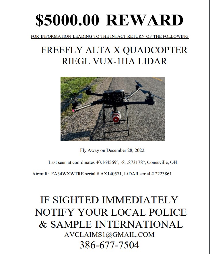
Fly away on December 28, 2022
Last seen coordinates 40.164569°, -81.873178°
Conesville, Coshocton County, Ohio
Aircraft: FA34WXWTRE
Serial Number: AX140571
LiDAR Serial Number: 2223861
If sighted immediately notify local police and Sample International avclaims@gmail.com Telephone Number: (386) 677-7504


Seems unlikely that the drone will be found intact after flying away from the controller and not doing the expected return to origin response for lost controller link.
ReplyDeleteDepends on the software settings.
ReplyDeleteI was curious why the reward was so large, this drone is AT MINIMUM $22,000
ReplyDeleteThat is wrong. That Riegl Payload is worth well over $250k.
DeleteI did not consider the scanner in the price, my bad. The price is considerably higher than I initially thought.
DeleteNeed a drone to help find it! 😄
DeleteDunno a lot about drones but was shocked by the reward $, so I priced this one out. $20K - $30K depending on options, loaded with tech, obviously not a toy. I'd think it would be able to survive lost comm, even if it didn't return to base. My guess is the pricey aircraft was either shot down, or is safe in someone's garage.
ReplyDeleteA badly crashed one of those sold recently on Ebay for $1200 as "parts". Wasn't this one's s/n. Not worth much when auto land doesn't give it an orderly landing.
ReplyDeleteThose wondering why so much reward for the drone. You all don't know how much the payload is. That payload is worth more than $250,000. I know we bought a similar payload and it was more expensive.
ReplyDeleteWhat are you calling the "payload"?
Delete
DeleteLaser surveying equipment on board.
The pricey RIEGL VUX-1HA LIDAR unit was the mounted payload.
DeleteCessna 421B = $5,000 Reward
ReplyDeleteBeech 58 Baron = $5,000 Reward
Piper PA34-200T Seneca = $5,000 Reward
Drone = $5,000 Reward
Interesting. I sure would like to locate that Beech 58 Baron in Florida.
The difference is that the drone reward in based on recovery "intact" whereas the aircraft are not? I presume they mean payload intact not the drone itself. Of course the payload could be sold on craigslist for $$$; but the drone owner is hoping that most people will be honest.
DeleteLIDAR surveying by drone over un-notified landowner's properties present an irresistible target. No video camera on board. Half a million bux at risk, even more enticing than a package delivery drone!
ReplyDeletehttps://www.canberratimes.com.au/story/5995159/commercial-drone-shot-down-police-launch-investigation/
I am an FAA licensed Remote Pilot . Seems like insurance or common sense when flying even a cheap drone would suggest attaching a cheap small GPS tracker to locate drone in the event of a flyaway like $25 Apple Air Tag tracker that is about the size of a quarter or slightly larger trackers attached to construction equipment to help recover after theft . Seems like a company building $22k drone would install a tracker as basic equipment . Also, seems like there would be a digital GPS record of the flight path on the remote controller . If the GPS failed on the drone , the Apple Air Tag type tracker should still work
ReplyDeleteAirTags work by making Bluetooth (=very short range...) connections to nearby iPhones/iPads that report the contact along with the phone's location. I guess we could send a bunch of iPhone users out tromping around the woods and see if anybody gets close enough to get a ping from the tag, but that's what it would take.
Delete"Seems like...common sense...." - Yeah, it does seem a bit suspicious. Even a GoPro camera would seem like a drop in the bucket to add to that drone (aka, Crashbus, um, correction, Airbus). It's like flying a 777 without nav equipment, a CVR and a FDR. I wonder if the owner has it stashed, or maybe he sold it and is awaiting his insurance check? Would love to see more "incidents" like this on KR.
Delete$500K? I'd have a transponder squawking 7600 on that bad boy 24/7. Suspicious, to say the least.
DeleteEven mini pro 3 ($500) has a find me feature; albeit to the last position recorded by the controller. Hard to believe this drone does not.
DeleteFull disclosure…I know zero about flying drones. Is it possible that the control signal was unencrypted and hijacked using a different controller?
ReplyDeleteSomeone could develop a takeover capability as an agency level espionage actor, but seems unlikely in a commercial situation that a person could position themselves in near proximity at the right time to deploy against a specific manufacturer's control design. That's a lot of specifics in combination to get it done. And this wasn't a DJI used in the thousands (the design that was expected to be routinely encountered).
DeleteAbout the Apple air tag: Relies on bluetooth to a nearby phone, range of 10 meters is all that is promised. Landing a hundred yards or more into the woods away from a nearby road, residence or hunter certainly would render it useless as a drone tag. Is LoJack still available?
So. Walk around and find it. I bet these people would pay $50,000 to have an airtag on their drone right now.
DeleteA flyaway while doing LIDAR forestry surveying might require a lot of walking in the woods before getting within 10 yards of the crash. Good thing about all of that walking is you can still complete your timber assessment by using old style methods while searching for your drone wreckage. Have to bring along an old guy who knows forestry to bail you out, but he won't need a vegan latte or complain about ticks or redbugs!
DeleteThere are indeed drone intercepting devices available but they would probably only sell them to select organizations, military, police etc. I wonder if this drone didn't fall into a pond, there appears to be one in the vicinity of the last coordinates given.
DeleteBattery life can be affected by several factors, including payloads.
ReplyDeleteHigh end drone should have return to origin default on getting close to low battery, auto land on low battery, etc. When they fly away, that's a malfunction that will end in a crash.
DeleteThere are small GPS trackers that require a SIM card to work like a cell phone. The SIM card requires activation with cell service provider like T-Mobile or AT&T . If object is lost or stolen, the owner calls a cell number for the SIM card in the GPS tracker that transmits its location via cell phone service. No Bluetooth required . No cell phone required within 30 feet . All that is needed is cell phone signal reception so GPS tracker can receive a call . Google LORISTAD® Magnetic Mini GPS Tracker . Price is $14.99 on Amazon . Insurance should require some type tracking device on all insured drones. If drone is found where there is no cell service available, finder will probably take it home where there is cell service so SIM card in tracker can send its location . If cell service is available at launch site, drone pilot Should be able to start tracker monitoring drone.before takeoff so entire flight can be tracked even if drone operates normally and returns to launch site .
ReplyDeleteLooked through the drone mfg's website to see if any kind of crash locator device option is offered - nope! Did see that insurance is offered through the drone manufacturer, nothing in their spiel there seems to recognize the need for a locator beacon - maybe it's an "our drones don't fly away" denial of reality.
DeleteLiDAR sensor can scan up to 800 acres per day.
ReplyDeleteBest of luck with its safe return.
Seems like FAA would require drone software to stop flying immediately if GPS signal is lost to prevent flyaway drone from entering restricted airspace or hitting airliners. After Malaysian airliner disappeared there was talk of installing tracking devices on all airlines but don’t think that ever happened . ADS-B is now required on all planes and can be tracked by public using adsbexchange free app.
ReplyDeleteWonder if New FAA rules requiring drones to broadcast their ID to help police identify drones may help track flyaway drones?
If the LiDAR laser camera on drone is used to scan rural land or farm land there may not be cell service to in rural areas to allow most cell service trackers to work.
But seems like this one flyaway should be warning to FAA that flyaway drones could hit airliners killing hundreds .
Here's the google map location as posted above as the "last seen" location. Looks pretty rural with lots of hills and dense woods surrounding.
ReplyDeletehttps://www.google.com/maps/place/40%C2%B009'52.5%22N+81%C2%B052'23.4%22W/@40.1608418,-81.872151,7141m/data=!3m1!1e3!4m5!3m4!1s0x0:0xd7082fbf1506427d!8m2!3d40.164569!4d-81.873178?hl=en
Will's Creek/Muskingum Watershed.
Deletehttps://www.mwcd.org/places/lakes/wills-creek-lake
given point is inside the fenced and gated Conesville Coal property. Altitude and direction is important even if erratic. Also remaining charge on batteries when lost.
DeleteAny idea of what direction it was heading when they lost it or altitude?
ReplyDeleteIt was flying erratically at the time
DeleteAny update if it was found or not?
ReplyDeleteNo not found as far as I know. I'm thru this region almost twice a month, it's very rural and wooded, and Coshocton is not near anything significant. I'm keeping my eyes out as I drive along those windy roads..
ReplyDeleteNo it has not yet been reported found.
ReplyDeleteLooks like KR no longer updating again. I wonder whats going on.......
ReplyDeleteIn the mean time the Aviation Safety Network provides international accident reports. No comment section though :( Hoping Kathryn comes back soon
DeleteUncivil and disrepectable comments, perhaps. The quality use to be high with few trolls and few personal attacks. No so much the last couple of years. I miss Kathryn’s and most of the comments. I learned a lot.
DeleteSeems prudent to put a $20 AirTag or similar gps tracker on a $5-10k drone.
ReplyDeleteI see an out of control drone not much different than shooting a gun in the air and hoping the bullet does not come down in a school yard full of kids.
ReplyDeleteDo you really have that much insurance?
Interesting to see that the Firefly OEM's website sells insurance coverage, up to 5 million dollars liability for certified drone pilots, but personal injury and medical coverage in the offering shows:
DeletePersonal Injury Coverage (Including Privacy)
$25,000 (Included), $100,000 at additional cost.
Medical Expense
$500 (Included), $1,000, $2,000, $5,000
Drone insurance doesn't have a long history to calculate from, and there are bigger drones out there that someday will wreck a person. Filing a lawsuit going after the manufacturer for a flyaway should produce an easy win if personal injury resulted.
When will the FAA and NTSB investigate this aircraft disappearance like any other aircraft that disappears?
ReplyDeleteWhen will FAA require ADS-B to be installed on all drones so public can track drones on adsbexchange or Flight Aware ?
The heavy crop spraying drones like the DJI Agras T40 Sprayer Drone can spray 52 acres (21.3 Hectare) per flight hour and has a
10.56 gallons (40 liters ) spray tank and a 110 lbs (50 Kg) Spreader Attachment
The DJI Agras T40 Spreader can carry 110 lbs (50kg) of dry material and has a 70 Liter tank.
Amazon and UPS drones can carry heavy payloads .
If a heavy drone has a flyaway it could cause serious damage and perhaps should have an ADS-B so public can track drones on a smart phone .
The NTSB will not investigate "aircraft" that are unregistered and don't have an "N" number.
DeleteAll drones used for commercial purposes are required to be registered with the FAA with registration number placed on the drone and behjninv in Sept 2023 all drones will be required to have a transmitter to broadcast their ID so police and FAA can identify the drone and owner winked it is flying .
DeleteThere is no Freefly Alta X Quadcopter listed in the FAA Database with the serial # listed AX140571
Deletehttps://registry.faa.gov/AircraftInquiry/Search/SerialNumberResult
There are other organizations that sometimes loose control of their vehicles who employ a Range Safety Officer to push a red button with spectacular results.
ReplyDeleteYes, these "organizations" are Government agencies that are paid for with taxpayer $$ that can afford a Range Safety Officer Like Sherrif, Police, Federal, etc.
DeleteWere they snoopin around the Conesville power plant and someone took umbrage?
ReplyDelete***News Flash*** from the FAA Registration database.
ReplyDeleteThe duration of aircraft registration certificates has been extended up to 7 years. The Registry will be issuing revised certificates in batches based on the former expiration date. For verification purposes, even though the expiration date on the registration certificate may not match the expiration date in the FAA Aircraft Registration database, any registration certificate displaying an expiration date of January 31, 2023, or later is still valid. This applies to all foreign Civil Aviation Authorities or anyone else with a verification need.