
The National Transportation Safety Board did not travel to the scene of this accident.
Additional Participating Entity:
Federal Aviation Administration / Flight Standards District Office; Oakland, California
Investigation Docket - National Transportation Safety Board:
Accident Number: WPR21LA199
Date and Time: May 18, 2021, 14:00 Local
Registration: N16CX
Aircraft: Harry Crosby (Vans) RV-6
Aircraft Damage: Substantial
Defining Event: Loss of control on ground
Injuries: 1 Minor
Flight Conducted Under: Part 91: General aviation - Personal
Analysis
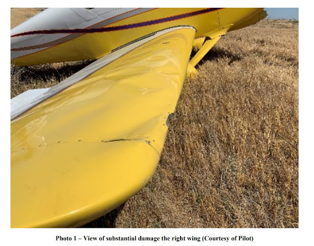
The pilot in the tailwheel-equipped airplane reported that, during the takeoff roll, the wind was variable and gusting from the left. He initiated the takeoff roll and applied left aileron and right rudder pedal pressure. The tailwheel lifted from the ground about 40 knots ground speed and the airplane veered to the left. Subsequently the pilot applied full right rudder and simultaneously applied full left aileron, but the airplane exited the left side of the runway. The pilot continued the takeoff roll as he believed that the airplane would start to climb. However, the airplane collided with a drainage culvert located about 25 ft from the left side of the runway. The airplane sustained substantial damage to the right-wing spar and ribs. The pilot reported that there were no preaccident mechanical failures or malfunctions with the airplane that would have precluded normal operations.
The METAR located at the accident airport reported that about the time of the accident, the wind direction was from 230° with a velocity of 20 knots and gusting to 25 knots. The pilot was departing from runway 23.
Probable Cause and Findings
The National Transportation Safety Board determines the probable cause(s) of this accident to be:
The pilot’s failure to maintain directional control of the airplane during takeoff while operating in gusting wind conditions, which resulted in a runway excursion and subsequent collision with terrain.
Findings
Aircraft Directional control - Not attained/maintained
Personnel issues Aircraft control - Pilot
Environmental issues Gusts - Effect on operation
Factual Information
History of Flight
Takeoff Loss of control on ground (Defining event)
Pilot Information
Certificate: Private
Age: 88, Male
Airplane Rating(s): Single-engine land
Seat Occupied: Left
Other Aircraft Rating(s): None
Restraint Used: 5-point
Instrument Rating(s): None
Second Pilot Present: No
Instructor Rating(s): None
Toxicology Performed:
Medical Certification: Sport pilot With waivers/limitations
Last FAA Medical Exam: October 27, 2020
Occupational Pilot: No
Last Flight Review or Equivalent: November 21, 2020
Flight Time: (Estimated) 2074 hours (Total, all aircraft), 1814 hours (Total, this make and model), 2031 hours (Pilot In Command, all aircraft), 28 hours (Last 90 days, all aircraft), 13 hours (Last 30 days, all aircraft), 1 hours (Last 24 hours, all aircraft)
Aircraft and Owner/Operator Information
Aircraft Make: Harry Crosby (Vans)
Registration: N16CX
Model/Series: RV-6
Aircraft Category: Airplane
Year of Manufacture: 2004
Amateur Built: Yes
Airworthiness Certificate: Experimental (Special)
Serial Number: 23159
Landing Gear Type: Tailwheel
Seats: 2
Date/Type of Last Inspection: June 11, 2020 Condition
Certified Max Gross Wt.: 1800 lbs
Time Since Last Inspection: 25 Hrs
Engines: 1 Reciprocating
Airframe Total Time: 1809.5 Hrs at time of accident
Engine Manufacturer: Lycoming
ELT: C91 installed, not activated
Engine Model/Series: O-360-A1A
Registered Owner:
Rated Power: 180 Horsepower
Operator:
Operating Certificate(s) Held: None
Meteorological Information and Flight Plan
Conditions at Accident Site: Visual (VMC)
Condition of Light: Day
Observation Facility, Elevation: KC83,393 ft msl
Distance from Accident Site: 12 Nautical Miles
Observation Time: 14:53 Local
Direction from Accident Site: 228°
Lowest Cloud Condition: Clear
Visibility: 9 miles
Lowest Ceiling:
Visibility (RVR):
Wind Speed/Gusts: 20 knots / 25 knots
Turbulence Type Forecast/Actual: /
Wind Direction: 230°
Turbulence Severity Forecast/Actual: /
Altimeter Setting: 29.99 inches Hg
Temperature/Dew Point: 28°C / 4°C
Precipitation and Obscuration: No Obscuration; No Precipitation
Departure Point: Byron, CA
Type of Flight Plan Filed: None
Destination: Livermore, CA (LVK)
Type of Clearance: VFR
Departure Time:
Type of Airspace: Class G
Airport Information
Airport: BYRON C83
Runway Surface Type: Asphalt
Airport Elevation: 78 ft msl
Runway Surface Condition: Dry
Runway Used: 23
IFR Approach: None
Runway Length/Width: 3000 ft / 75 ft
VFR Approach/Landing: None
Wreckage and Impact Information
Crew Injuries: 1 Minor
Aircraft Damage: Substantial
Passenger Injuries:
Aircraft Fire: None
Ground Injuries:
Aircraft Explosion: None
Total Injuries: 1 Minor
Latitude, Longitude: 37.828444,-121.62583 (est)


No comments:
Post a Comment