
The family of a Washington man who died in a plane crash deep in the Mount Jefferson Wilderness say they’re facing a $25,000 to $50,000 bill to remove the plane’s debris from a steep mountainside far from any road.
Wayne Wirt, 67, of Chehalis, Washington, died about 4:15 p.m. September 22 when his Piper PA-28-140 Cherokee crashed just south of Mount Jefferson on a high peak during a solo flight between California and Washington.
Wirt, who built movie sets in southern California before retiring to Chehalis years ago, leaves behind a wife and three children who now bear the cost of paying to have the plane’s debris removed from a location that’s extremely difficult to access.
“This heavy cost falls on (the) family to cover,” wrote April Winters, Wayne’s daughter-in-law, on a GoFundMe page set up to help raise the money.
She said the National Transportation Safety Board (NTSB) and Linn County Sheriff's Office are looking into what caused the crash.

Pilot Wayne Wirt, left, of Chehalis, Washington, died in a plane crash in late September in Mount Jefferson Wilderness.
~
This is preliminary information, subject to change, and may contain errors. Any errors in this report will be corrected when the final report has been completed.
Investigator In Charge (IIC): Stein, Stephen
The National Transportation Safety Board traveled to the scene of this accident.
Additional Participating Entities:
Dee Rice; Federal Aviation Administration / Flight Standards District Office; Portland, Oregon
Piper Aircraft Company; Vero Beach, Florida
Lycoming Engines; Williamsport, Pennsylvania
Location: Sisters, Oregon
Accident Number: WPR22FA354
Date and Time: September 22, 2022, 14:39 Local
Registration: N7063R
Aircraft: Piper PA-28-140 Injuries: 1 Fatal
Flight Conducted Under: Part 91: General aviation - Personal
On September 22, 2022, about 1439 Pacific daylight time, a Piper PA-28-140, N7063R, was destroyed when it was involved in an accident near Sisters, Oregon. The pilot was fatally injured. The airplane was operated as a Title 14 Code of Federal Regulations Part 91 personal flight.
The pilot used an online flight planning tool for his enroute and destination performance planning. Data retrieved from the online tool showed that the pilot had planned to depart a private strip in Llano, California about 0700 and then fly a succession of waypoints and fuel stops while enroute to his final destination of Curtis, Washington (0WA2). The data did not include any flight tracking information such as global position system coordinates. His planned route of flight comprised the following waypoints (in the reported order): Rosamond, California (L00), Sanger, California (9CA7) followed by a stopover in Jackson, California (JAQ). Fuel records from the JAQ airport showed that the pilot purchased 25 gallons of 100 low lead aviation grade gasoline at 0953. The pilot’s subsequent waypoints included Nevada County, California (GOO) followed by Sisters, Oregon (6K5) where the pilot purchased another 29 gallons of fuel at 1400. According to an airport surveillance video, the pilot departed 6K5 about 1410. He had planned to fly through Scappoose, Oregon prior to landing at his final destination.
A witness located about 0.50 nm north of the accident site heard the airplane during its final moments. The witness reported that between 1430 and 1445 she heard a small airplane that was flying close to her that caught her attention. She heard a “thud” sound approximately 30 seconds later at which point she began to look for the airplane. The witness stated that the engine sounded smooth and continuous prior to impact. Another witness, who was located about 1,000 ft from the accident site, stated that he heard the airplane impact the ground about 1439.
According to both witnesses, the ground visibility was low due to thick fog at the time of the accident.
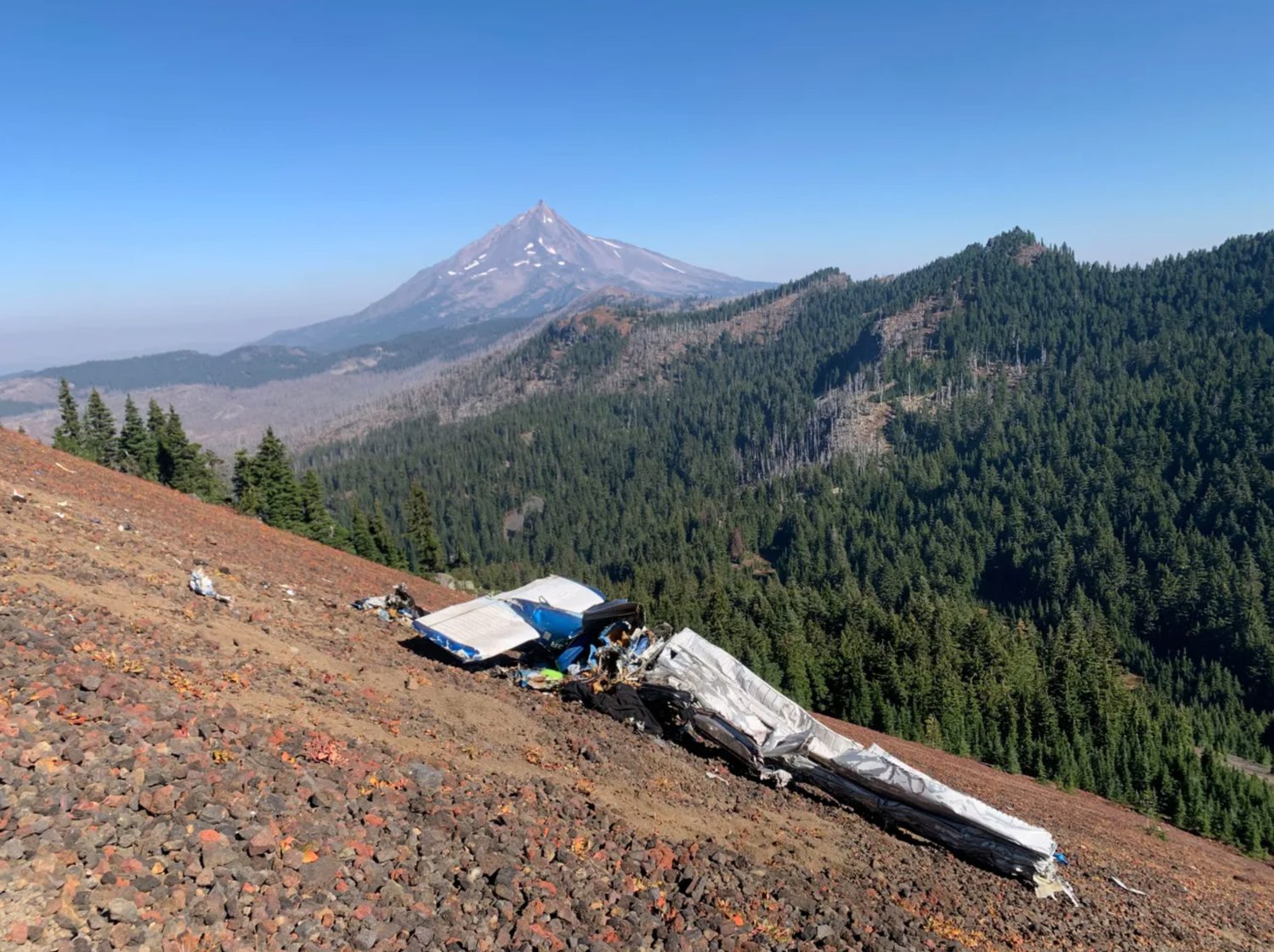
The airplane came to rest on a 60° slope on the northeast side of South Cinder Peak in the Jefferson Wilderness at a field elevation of about 6,500 ft mean sea level. All four corners of the airplane were accounted for at the accident site. The first point of impact (FPI) was about 500 ft from the top of the peak and was marked by a large ground scar about 6 feet wide. The main wreckage was located down the hill about 20 ft northeast of the FPI and was comprised of both wings, the fuselage and empennage. The engine was collocated with the FPI.
The right and left ailerons were attached to their respective wings, which remained attached at the carry through spar. Both wing leading edge surfaces were crushed chordwise and the leading edge skin forward of the fuel tanks exhibited evidence of hydraulic deformation. The right and left wingtips had separated from their respective wings. The airplane fuselage and cabin were crushed beneath the wings and could not be identified due to their orientation at the accident site. The empennage was inverted, which exposed the anti-servo tab and both stabilators. The vertical stabilizer and rudder assembly were crushed, but remained partially attached to the empennage. Several airframe fragments were distributed along the slope of the peak, below the main wreckage.
The wreckage has been retained for further examination.
Aircraft and Owner/Operator Information
Aircraft Make: Piper
Registration: N7063R
Model/Series: PA-28-140
Aircraft Category: Airplane
Amateur Built:
Operator: On file
Operating Certificate(s) Held: None
Operator Designator Code:
Meteorological Information and Flight Plan
Conditions at Accident Site: IMC
Condition of Light: Day
Observation Facility, Elevation: KRDM,3084 ft msl
Observation Time: 13:56 Local
Distance from Accident Site: 34 Nautical Miles
Temperature/Dew Point: 21°C /6°C
Lowest Cloud Condition: Clear
Wind Speed/Gusts, Direction: 13 knots / , 310°
Lowest Ceiling: None
Visibility: 10 miles
Altimeter Setting: 30.11 inches Hg
Type of Flight Plan Filed: None
Departure Point: Sisters, OR (6K5)
Destination: Curtis, WA (0WA2)
Wreckage and Impact Information
Crew Injuries: 1 Fatal
Aircraft Damage: Destroyed
Passenger Injuries:
Aircraft Fire: None
Ground Injuries:
Aircraft Explosion: None
Total Injuries: 1 Fatal
Latitude, Longitude: 44.569412,-121.80544 (est)
Those who may have information that might be relevant to the National Transportation Safety Board (NTSB) investigation may contact them by email witness@ntsb.gov, and any friends and family who want to contact investigators about the accident should email assistance@ntsb.gov. You can also call the NTSB Response Operations Center at 844-373-9922 or 202-314-6290.


Insurance won’t cover wreckage recovery?
ReplyDeleteThe idiot didn't HAVE insurance, and now the family wants all of us to foot the $50,000 bill for the wreckage removal. They had enough money to move to Washington from California, they had enough money to have five kids, and they had enough money to pay for avgas to make the trip. Their GoFundMe page has the complete sob story. Finally, what was he doing in IFR conditions as a single pilot at his age? Yes, I can say that because I'm 69.
DeleteReport says weather was clear of clouds and 10 miles visibility at time of crash not IFR . However, 2 Witnesses said thick fog was present at time of crash. Not sure why report differs from witness accounts of weather . Also no flight track on Flight Aware. Son was an A&P mechanic per gofundme info. Not sure of altitude of mountain but Cherokee 140 does not have much power to climb above high mountains . Most crashed planes are removed by FAA to investigate crash . Family should leave plane where it crashed . Many crashed planes are left on mountains. Steve Fossett’s crashed plane was left on mountain. Searchers looking for Steve Fossett saw many other crashed planes during search for Fossett.
Delete"Family should leave plane where it crashed". Um, did you read the gofundme? The family said "Forest service told us it isn’t an option to leave the plane where it is." I'm sure the Forest service doesn't want people leaving wreckage all over their land. Would you want someone leaving a crashed plane on your property?
Deleteits not owned by the park service its public lands they just manage it.
DeleteAircraft was removed, free of charge to the family, by HeavyDSparks. Recovery footage is on his YouTube channel.
DeleteI presume. Fly girl never made a mistake! Wow I now at your feet! What a horrible I feeling cruel thing to say about the death of a fellow aviator who was a commercial pilot (therefore instrument rated) but got caught out.
DeleteI’m reminded of the statement “you who are without sun may cast the first stone”
Video of the recovery of the aircraft, by volunteers who expended considerable personal funds, at no charge to the family :
Deletehttps://www.youtube.com/watch?v=utB9YApOBQc
Anonymous November 1st: A commercial license DOES NOT mean a pilot has an instrument rating. I have both - they have to be obtained separately. In order to sound credible, you should check your facts and learn to write in English more effectively.
DeleteFlygirl is a unfeeling bitch
DeleteMy condolences to the family
My admiration to HeavyDSparks! They are my heroes as always!
Regarding flygirl...Most of the dead people on this website probably made mistakes to get that way.. really not constructive to call them idiots and boast about licenses, etc. , make assumptions about the family's ability to remove wreckage. I doubt that they can be called responsible for it- the guy's estate, sure. The kids, though? What are you thinking?
Delete" Report says weather was clear of clouds and 10 miles visibility at time of crash not IFR . " That weather observation was from Redmond Airport, whcih is almost 40 miles away. The weather can be significantly different in that distance.
DeleteFlygirl thats not ok in any way shape or form
DeleteFlyGirl, I just wanted you to know that you’re a real piece of sh!t.
DeleteFly girl here to let you know they had the money but the bank wouldn’t let them have it without a death certificate. His body was trapped on that mountain until they had money to recover. You’re a monster, calling you an American disgraces our great nation
DeleteI'd tell whatever authorities that are pushing the billing of this recovery of this wrinkled up mess of aluminum to, "sit on it and spin!" There are no legal requirements or laws that can be enforced to make this happen.
ReplyDeleteAre you certain of that statement? If not, it might have been better kept to yourself. This is a tragedy and out of respect to this unfortunate pilot’s family and loved ones we should use some care in what we say in public forums that they probably read. RIP
DeleteSince there are so many family members, why don't they organize a trip to remember dad by removing the wreckage from our rapidly-diminishing wilderness areas?
DeleteFrom the things you write Fly, it's difficult to tell if you are a complete moron, or just an ***hole. Clearly you know nothing of the wreck site, or wilderness areas. The wreck was in a National Wilderness Area. They are not rapidly diminishing in fact they are the most heavily protected lands we have and for this reason recovery was extremely complicated and costly. Here's a thought, educate yourself on the facts before you open your old crotchety worthless mouth. Skank.
DeleteI might be old, but I'm still alive after flying professionally for over forty years.
DeleteIt is great that you were so careful! By why haven't you stopped flying, given the greater number of avoidable disasters with old pilots (old people)?
DeleteFirst of all, go fuck yourself flygirl , your old ass should be fuckin killed for the way your talking about the deceased, you don’t belong and are not welcomed into the aviation community under any circumstances except to kiss my ass. Guess what, someone already came in and removed all of it at no cost to the family. So get fucked, and stay mad loser. Also hope your still alive to read this.
DeleteHard not to agree with flygirl. Dude was irresponsible six ways from sunday, and burdened his family real bad for no good reason. I for one, DO NOT have a olane... you ALL have clearly lost sight of what real need and real tragedy looks like. Wife had no funds w\0 death certificate... Sounds like a basic patriarchal man going off and flying around like he's god. Well me and god.both think he.can get bent. hope his ex finds a better guy who is more responsible to his family.
DeleteThis does not add up. According to the preliminary NTSB report „The wreckage has been retained for further examination“. In other words: it has already been removed from the crash site and there is not the slightest indication that the NTSB has asked for reimbursement.
ReplyDeleteThey might have just taken only what was recoverable and pertinent to an investigation that fits this profile. They probably took the engine and checked what was left of the controls for continuity. It would be interesting to see how they got access to the site. This sounds like a VFR into IMC with CFIT until proven otherwise.
Deletehttps://www.youtube.com/watch?v=utB9YApOBQc
DeleteI was thinking the same thing, plus the cost of a utility helicopter to remove less than 2,500 pounds (the empty weight of that plane) is nowhere near $25,000 to $50,000.
ReplyDeletehttps://www.globalair.com/aircraft-for-sale/specifications?specid=99
A light utility helicopter should be able to lift from 1200 to 4000 pounds or 0.6 to 2 tons total @ a cost of maybe $300/hour.
https://valrin.com/how-much-does-it-cost-to-rent-a-helicopter/
$300 an hour, your nuts. Try more like$2500 an hour for a light helo.
Deletehttps://pilotteacher.com/how-much-does-it-cost-to-rent-a-helicopter/
DeleteRental for lessons … yeah, maybe $300 an hour. For trash removal? Not that cheap.
DeleteI can't believe the NTSB, forest service and Sheriff dept. went up to the crash site and only removed part of the remains.
Delete"Another important power bestowed on the NTSB by Congress is the right to take exclusive custody of the wreckage, cargo and records of the accident aircraft. This exclusive access has been challenged by a number of private litigants with significant success in the courts. The NTSB counter-attacked with the 1990 Amendments to the Independent Safety Act. Now, the NTSB may exclude interested persons, such as the pilot, the owner or the families of the victims, from any participation or observation of the wreckage testing and analysis."
ReplyDeletehttps://www.avweb.com/aviation-news/ntsb-accident-investigations-what-you-need-to-know/
He had no insurance. He was irresponsible. Therein lies the problem.
ReplyDelete"Insurance for a small aircraft will cost around $1,500 to $2,000 per year, but the amount of coverage and cost will vary significantly by the type of policy, aircraft, flight, and pilot."
ReplyDeleteBecause they can legally exclude the pilot, owners, and or family, etc., the NTSB/FAA covers the cost of removal of the wreckage to the storage facility.
I would not be too surprised that this is another non-instrument rated pilot/ no current medical or basic med / VMC to IMC accident
ReplyDeleteThis is the info for the only "Wayne Wert" listed in the Airmen Database:
DeleteWAYNE NORMAN WERT
Medical Information:
No Medical Information Available
Certificate: COMMERCIAL PILOT
Date of Issue: 2/28/1976
Ratings:
COMMERCIAL PILOT
AIRPLANE SINGLE ENGINE LAND
INSTRUMENT AIRPLANE
If you search for WAYNE WIRT you get:
DeleteWAYNE ALLISON WIRT
PO BOX 253
LLANO CA 93544-0253
County: LOS ANGELES
Country: USA
Medical Information:
Medical Class: Third Medical Date: 7/2013
MUST WEAR CORRECTIVE LENSES.
BasicMed Course Date: 4/19/2018 BasicMed CMEC Date: 4/5/2018
Certificates
PRIVATE PILOT
REPAIRMAN EXPERIMENTAL AIRCRAFT BUILDER
Certificates Description
Certificate: PRIVATE PILOT
Date of Issue: 4/11/2012
Ratings:
PRIVATE PILOT
AIRPLANE SINGLE ENGINE LAND
Limits:
ENGLISH PROFICIENT.
I think the one running the gofundme page has misinformation about being responsible for paying for wreckage removal. I hope it’s not a scam!
ReplyDeleteTell whoever is trying to collect for removal to sue the estate. Otherwise they can pound sand.
ReplyDelete“ Tell whoever is trying to collect for removal to sue the estate. Otherwise they can pound sand.”
DeleteLet me guess, you don’t have insurance either. We are all paying for guys like you.
No … I carry insurance. If the family was not part of the ownership or operation of the aircraft they have no obligation.
DeleteIf one of your relatives should have an accident on the interstate causing a multiple vehicle pileup should you be responsible if your relative had really good but insufficient coverage for the event, would you jump in and pay it?
Forest service told pilot's wife that the wreckage can't be left on the mountain. A pilot's still married wife (if not an ex-wife) gets stuck with the expense in this circumstance. After the portion or items of wreckage retained for further examination are taken by investigators, a lot can be left behind.
DeleteGotcha.
DeleteInsurance has many ways to deny coverage . Often courts can award verdicts in excess of coverage amount . Many policies don’t pay much per passenger .
ReplyDeleteHe crashed onto a 30 degree slope in the middle of nowhere. I can understand the high cost of removing the wreckage if performed in a safe way. Take a look at the topo map and see:
ReplyDeletehttps://peakery.com/south-cinder-peak-oregon/map/
\\\
The nearest trailheads appear to be about 6 miles away. The nearest main roads about 10 miles away. The nearest town looks to be about 30 miles away if there were a direct route.
ReplyDeleteThe report states that it was a 60 degree slope.
DeleteI stand corrected. I wonder if one can even land a helicopter on a 60 degree rocky slope.
DeleteNo need to land, just have a cleanup crew hike up, put the debris in a net or tarp bag with a bridle, call the helo. Plenty of helo logging operators in the region that could long line it off the slope.
DeleteAs of now the GoFundMe account has over $2600.
ReplyDeleteA fool and his money are soon parted.
DeleteI agree.
DeleteI disagree!!!
DeleteIf you are a current flyer Flygirl, how can you justify a fellow aviator losing their life while flying, however the circumstance?! I myself have only 200 hours logged, (not flown solo in ten years), not a statistic yet, only waiting for time itself, ha ha. Not wanting to pick an argument, but in my past 200 hours, maybe I am a lousy pilot, but I survived situations to where maybe the high being in the sky let me live another day for some reason... This family is going through a not so positive situation, be glad we are not going through this as well, I wish the best for you Flygal
Delete!!!
Contact the Oregon Army Guard at Salem. They may do it as a training exercise.
ReplyDeleteThat's an interesting idea.It might require some complicated logistics since the impact point was higher up the mountain. I don't know if there is any debris closer to the peak that has not been pictured. The NTSB probably already measured and dealt with any hazardous fluids that were still present.
DeleteAt a cost nowhere near $25,000 to $50,000! Why did the Forest Service say that?
ReplyDeleteGo Fund Me ??? Go F*ck You !!!
ReplyDeleteHeavyDSparks and friends removed the wreckage for the family. Honourable folks they all are.
ReplyDeleteWild to see how little heart some of these folks have. HeavyD is good people.
DeleteThe video of removing is up on his channel.
ReplyDeleteMan! Im a pilot and I choose to increase my life insurance and not carry any insurance on my aircraft. I would hate to have an accident and have family see these types of comments. I kind of want to stop flying after reading all these SH**TY comments. Its so sad that there are so many people out there that would say stuff like I am seeing in these comments!
ReplyDeletethose little piper 140s are excellent instrument airplanes. stable and steady easy to maintain attitude. equipped with a gyro horizon and all that other stuff that you need. all you need to do is just stay up high enough so you dont hit the ground.
ReplyDeleteEven if the pilot (most probably) used some rather risky mountain flying tactics and was most probably flying VFR in very adverse weather conditions (in a high mountain area/region) and so he unfortunately crashed his airplane and he was killed. This all shouldn't trigger such hateful (and very crude) comments/remarks as it did here. May he rest in peace (RIP)....
ReplyDeleteThe plane has been removed by a guy with the skills to get a bunch of people together to get the job done
ReplyDeleteI fly through the area routinely and I'm also a commercial rated pilot. Aviation is unkind mistress. It is seductive in it's beauty and harsh in it's judgement. My guess is he had a medical event and lost control. Lots to learn from this accident and the wonderful people that helped the family out in their most definite time of need.
ReplyDeleteAll speculation at this point. I was thinking that due to the thick fog and low clouds, but sunny elsewhere, he was dodging clouds threading the needle through the Cascades to get on the west side and CFIT'd into the mountain. The fact 2 witnesses heard the airplane in essentially a steady state cruise (no revving of the engine or noises like aerobatics) points to a CFIT, especially since it was at the 6500 ft MSL level, indicating a likely cruise altitude. Shrug, but we'll stay posted to see what they find. RIP.
DeleteA friend of mine crashed into Stallion Springs with his Baron G-58 (N533Q) in bad weather. The dead were removed, but the airplane remains on top of the mountain. I'm told the Forest Service doesn't care if the plane is removed or not. It was insured.
ReplyDeleteCorrection: D55 not G-58
DeleteIt’s odd the report never mentions what phase of flight the accident occurred; takeoff, climb, cruise, descent, landing and if returning to the airport. Also nothing mentioned about his last radio transmission. Another point, sounds like he illegally took off or flew into IFR conditions without an instrument rating. It cost money to get the rating. But it also costs about the same to recover your non-instrument rated body.
ReplyDeleteFinal NTSB report: VFR into IMC w/o instrument rating. No weather briefing and occurred in cruise flight.
ReplyDelete