
The National Transportation Safety Board traveled to the scene of this accident.
Additional Participating Entity:


Federal Aviation Administration / Flight Standards District Office; Van Nuys, California
305L Air Holdings LLC
Location: Camarillo, California
Accident Number: WPR22FA210
Date and Time: June 10, 2022, 08:03 Local
Registration: N305L
Aircraft: MOONEY AIRCRAFT CORP. M20K
Injuries: 1 Fatal
Flight Conducted Under: Part 91: General aviation - Personal
On June 10, 2022, about 0803 Pacific daylight time, a Mooney M20K, N305L was destroyed when it was involved in an accident near Camarillo, California. The pilot was fatally injured. The airplane was operated as a Title 14 Code of Federal Regulations Part 91 personal flight.
The pilot had flown in from his home base of Phoenix Deer Valley Airport (DVT) the day before the accident to play golf in the Camarillo area, and the accident flight was to be his return trip. About 0730 he contacted Leidos Flight Service and requested an abbreviated weather briefing. The briefer stated that a marine layer was present in Camarillo, and the pilot responded that it was, “socked in”. He requested cloud top information and was provided with the closest pilot report (PIREP), which indicated 700 ft cloud tops at Los Angeles International Airport (LAX) which was along the coast, about 40 miles to the east. The pilot responded, “there you go”, and after receiving information on a local temporary flight restriction (TFR), he asked how he should file a VFR-on-top flight plan, and if he could file it with the briefer. The briefer stated that he would need to file an instrument flight rules (IFR) flight plan, with a VFR-on-top clearance, and that they could do it immediately.
With the flight plan filed, at 0749 the pilot contacted the Camarillo tower controller. Weather at the time included calm wind, visibility of 4 miles, and 300 ft overcast ceilings and mist.
The controller provided the pilot with the IFR clearance to DVT, with instructions to turn right to 275° after departure for radar vectors, climb and maintain 3,000 ft, and expect 7,000 ft, 5 mins after departure. The pilot replied, but had omitted the initial 3,000 ft altitude instruction, and was corrected by the controller. About 8 mins later, the pilot responded that he was ready to taxi, and was given instructions to taxi to runway 26 via taxiways F and A. Over the next few minutes, the pilot began to taxi, but appeared to be using taxiway G. He told the controller that this was the first time he had flown from CMT and was given amended taxi instructions to the runway 26 runup area.
At 0801, the pilot was cleared for takeoff, and about 90 seconds later was given instructions to contact the departure controller. The pilot responded, however he did not contact the departure controller. About one minute later, a controller from Southern California TRACON (SCT) called the CMT tower controller to ask if the airplane had taken off, because they had not made contact, and had not seen the airplane on their radar console.
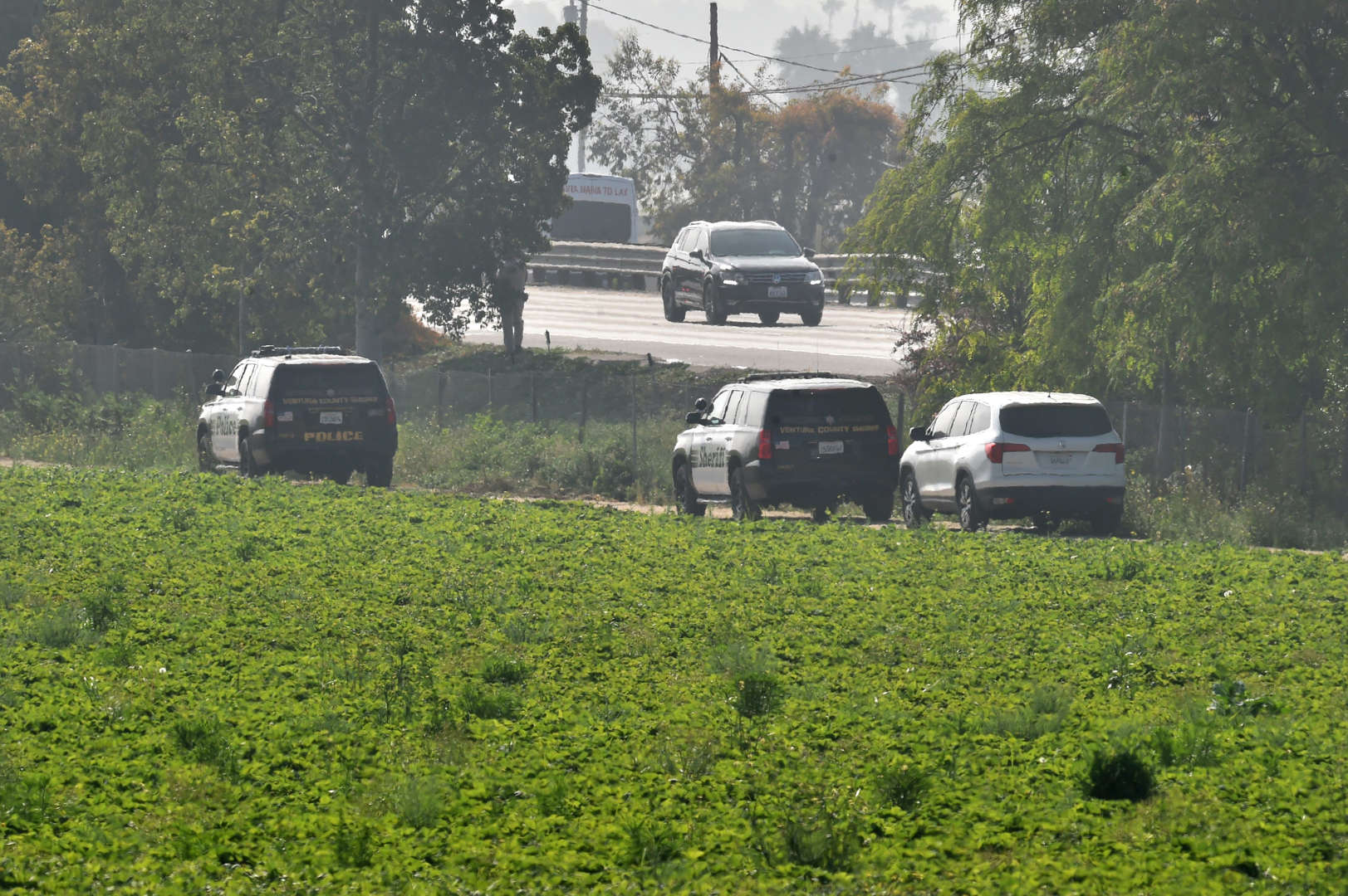
Multiple witnesses driving along Route 101, which was a freeway located parallel to the departure runway and about ½ mile north, reported seeing a low flying airplane travelling at high speed from south to north. They stated that the airplane then collided with the ground just past the freeway, and a fireball ensued. A video from a dashboard mounted camera from one of the witnesses corroborated their accounts and revealed that the airplane was flying just above the height of adjoining power lines. It did not appear to be trailing any smoke or vapors prior to impact.
The first point of impact was identified by a wing-shaped imprint at the top wall of a building located south of the freeway, and one mile west-northwest of the departure end of runway 26. The imprint was about 50 ft above the ground, and its shape corresponded to a 15° right-wing low impact attitude. The outboard section of the right wing and aileron were located on the buildings flat roof. A trail of debris consisting of wing skin fragments and the right flap continued on a heading of 035 degrees, across the freeway to a secondary impact point in a strawberry field, 750 feet beyond.
The debris beyond the secondary impact point consisted of the propeller, cabin skin fragments, and flight instruments, all leading to the main wreckage, which was on the same heading, about 250 ft downrange. The airframe sustained extensive impact and thermal damage through to the leading edge of the tail assembly. Impact and thermally damaged remnants of the entire left wing, along with the inboard section of the right wing remained attached to the center of the cabin.
Aircraft and Owner/Operator Information
Aircraft Make: MOONEY AIRCRAFT CORP.
Registration: N305L
Model/Series: M20K
Aircraft Category: Airplane
Amateur Built:
Operator: On file
Operating Certificate(s) Held: None
Operator Designator Code:
Meteorological Information and Flight Plan
Conditions at Accident Site: IMC
Condition of Light: Day
Observation Facility, Elevation: KCMA,71 ft msl
Observation Time: 07:55 Local
Distance from Accident Site: 2 Nautical Miles
Temperature/Dew Point: 16°C /14°C
Lowest Cloud Condition:
Wind Speed/Gusts, Direction: / ,
Lowest Ceiling: Overcast / 300 ft AGL
Visibility: 4 miles
Altimeter Setting: 29.88 inches Hg
Type of Flight Plan Filed: VFR/IFR
Departure Point: Camarillo, CA (CMA)
Destination: Phoenix, AZ (DVT)
Wreckage and Impact Information
Crew Injuries: 1 Fatal
Aircraft Damage: Destroyed
Passenger Injuries:
Aircraft Fire: On-ground
Ground Injuries:
Aircraft Explosion: None
Total Injuries: 1 Fatal
Latitude, Longitude: 34.223557,-119.12531
Those who may have information that might be relevant to the National Transportation Safety Board (NTSB) investigation may contact them by email witness@ntsb.gov, and any friends and family who want to contact investigators about the accident should email assistance@ntsb.gov. You can also call the NTSB Response Operations Center at 844-373-9922 or 202-314-6290.


Aircraft crashed under unknown circumstances shortly after departure striking the roof of a building.
Date: 10-JUN-22
Time: 15:00:00Z
Regis#: N305L
Aircraft Make: MOONEY
Aircraft Model: M20K
Event Type: ACCIDENT
Highest Injury: FATAL
Total Fatal: 1
Flight Crew: 1 fatal
Pax: 0
Aircraft Missing: No
Damage: DESTROYED
Activity: PERSONAL
Flight Phase: TAKEOFF (TOF)
Operation: 91
City: CAMARILLO
State: CALIFORNIA


What appears to be the left wing of the aircraft
ReplyDeletehttps://www.gannett-cdn.com/presto/2022/06/10/PVCS/0fd9a704-b194-40a2-8221-a779e658674b-roof_photo.jpg
was found on the roof of the Ventura Hose-man building
https://goo.gl/maps/Q5vS18qSsb1Y8xaLA
The main wreckage of the aircraft was found on the other side of the 101 freeway in a strawberry field on an approximate 030 heading from the wing impact on the Hose-man building. That heading is about 120 degrees right of the 275 heading the aircraft was supposed to turn to at 400 AGL as part of the departure procedure. It would appear that the pilot got disoriented and continued his turn right well past the intended heading and lost altitude. The plane had a fairly shallow descent angle as shown by the flight path which continued another 600 feet after wing impact on the building and miraculously across the 101 freeway before impacting the strawberry fields on the other side.
Some raw video from the crash scene: https://www.youtube.com/watch?v=h8KsTmg3Vqg
Definitely outer wing section, by paint compare to for sale photo:
Deletehttp://buyaircrafts.com/resimler/1982-mooney-m20k-305-rocket-for-sale-0.jpg
Remarkable distance after shedding some wing.
From:
https://buyaircrafts.com/2017/03/21/1982-mooney-m20k-305-rocket-for-sale/
Based on the photo of when it was for sale provided here, that is actually the right wing according to the paint design pattern (wider red paint part towards the front tapering towards the back). Then there's the missing tip exposing the general familiar tear drop shape cross section of the wing as well as the remnants of where the aileron was. That was a lot of damage to snap that wing off. And as someone else posted, how that thing even made it across the runway after that impact and not spiral into cars on the 101 below is a miracle.
DeleteYep yep, right wing, not left. The right wing impacting the building also matches the plane being in a continuing right banked descending turn, presumably carrying a lot of forward airspeed.
DeleteCleared power lines out front after striking the building:
DeleteStreetView:
https://goo.gl/maps/9PCSUYhWPYAz4Ezm7
The visibility looked to be 3/4 of a mile, so spatial disorientation could have factored in this mishap. Mooney's are pretty hot little numbers, and they're not very forgiving, though the early versions I flew had pneumatic wing levelers, which required pilots to poke a button on the yoke before they could bank them.
DeleteThe LLC address and a business using that address leads to a Commercial Certificate pilot with instrument rating:
ReplyDelete16230 N 16TH ST
PHOENIX AZ 85022-2854
County: MARICOPA
Country: USA
Medical Information:
Medical Class: Third Medical Date: 7/2014
MUST WEAR CORRECTIVE LENSES FOR NEAR AND DISTANT VISION.
BasicMed Course Date: 5/6/2019 BasicMed CMEC Date: 5/6/2019
Certificate: COMMERCIAL PILOT
Date of Issue: 11/14/2012
Ratings:
COMMERCIAL PILOT
AIRPLANE SINGLE ENGINE LAND
AIRPLANE SINGLE ENGINE SEA
INSTRUMENT AIRPLANE
Limits:
ENGLISH PROFICIENT.
Aviatondb registration history check shows the related business name first registered the Mooney in 2007.
It's quite possible that the pilot has a pending BasicMed Course Date update that hasn't hit the FAA database yet. But if not, the Pilot's Basic Med course (and legality to fly) would have expired 10 days before the accident.
Delete^Incorrect:
DeleteUnder BasicMed for a third class medical, a pilot will be required to complete a medical education course every two years, undergo a medical examination every four years, and comply with aircraft and operating restrictions, if over 40 years old.
If there were no restrictions placed on his medical, it would have expired 05/31/2021, A year earlier.
Medical certificate or not, it sounds like he had a TIA (transient ischemic attack) or a stroke at take off. They don't realize that they are not making sense.
ReplyDeleteThe 2017 for sale ad listed a JPI EDM Instant TIT/EGT/CHT readout, which if not irreparably damaged in the crash, could provide engine data of the accident takeoff. Recovered data showing engine performance would help sort out whether low ceiling, medical event or engine performance caused the low altitude that resulted in striking the building.
ReplyDeleteJPI EDM data report from N9261L's Texas accident provides an example:
https://data.ntsb.gov/Docket/Document/docBLOB?ID=12879547&FileExtension=pdf&FileName=CEN21FA290%20Engine%20Data%20Monitor%20-%20Specialist%27s%20Factual%20Report-Rel.pdf
The pilot sounded confused and made numerous mistakes on his clearance readback (missed reading back "direct" and initial altitude of 3000, said 10 minutes instead of 5 for the expected time, etc.) and got confused during the taxi. Confusion and mistakes like that seem to go hand in hand with a pilot muffing the departure procedure and crashing.
ReplyDeleteThe way he read back "on takeoff, fly heading 275" instead of "on departure" may indicate that he thought he was supposed to turn to 275 immediately after takeoff, forgetting the basic IFR departure rule that you MUST climb straight out on runway heading to at least 400 feet above the departure end of runway elevation before making ANY departure turn—calculating and saying that 400-foot altitude is an essential part of every takeoff briefing. Turning any earlier is an excellent way to hit buildings, obstacles, terrain, or just become disoriented.
I had the same impression listening to his read-back. Also, the weather was low IFR with 300’ ceilings. That’s not against the regulations, but probably not advised if you are unfamiliar with the area and minimally current with your instrument requirements. If the pilot was the owner of the LLC tied to the plane, which I suspect, then he had the instrument and commercial ratings. How current or proficient he was then is another question to be answered—all unfortunate.
DeleteBe aware that not all pilots feel this way about being current and personal minimums. Some feel that being current means that you are comfortable flying approaches to published minimums and that so-called personal minimums should not be used. There have been many debates on this topic and I don't mean to start another one here. I just want to point out that not everyone agrees that "IFR current" represents a spectrum of proficiency.
Deleteconcerning IFR approaches, comfortable until the unexpected "Al Diehl, a former National Transportation Safety Board investigator, said the recording between air traffic control and Das indicates he was trying to deal with a major distraction or significant emergency on his own, breaking a basic rule that aviators should always tell controllers everything.
Delete“The first thing you do when you’re in trouble is call, climb and confess — and he did not do any of the three,” Diehl said. “These are very basic rules that flight instructors tell their students.” as addressed http://www.kathrynsreport.com/2021/10/fatal-accident-occurred-october-11-2021.html
Dr. Jacob was a fantastic pilot. RIP.
ReplyDeleteThe NTSB final is out: NOT IFR current, NO current medical. PILOT ERROR by stubborn old man who wouldn't even ask for progressive taxi instructions at an unfamiliar airport. DID NOT get waiver for mitral valve replacement. The only positive thing to happen was that he miraculously failed to hit any cars on the 101 freeway. This pilot had no business flying with known heart issues including a pacemaker. What a selfish jerk.
DeleteYet another Doctor killed piloting a light aircraft - why so many??
ReplyDeletehighly intelligent self selected group feels like they can do anything after the rigors of becoming a practicing physician. aviating has never been forgiving of fools or hubris.
DeleteHe clearly could not climb. What’s the first thing you would do if you experienced engine failure at such a low altitude? Best place to land. He had tunnel vision trying to land in that field. Thousands of homes directly in front of him and lots of buildings to the left. He banked a sharp right and did everything he could not to crash into the 101 traffic below him. Wings on the Mooney sit low. He was a hero in my opinion for putting it down in that field.
ReplyDeleteI fly out of Camarillo often. There are many farm fields both off the departure end of 26 and north of the field. Also an engine failure does not coincide with the high bank angle and airspeed required to lose the wingtip on a building, then clear power lines, the 101 highway, and trees.
DeleteThere have been several Mooney mishaps from improper trim setting on takeoff, which caused nose high pitch that turned into stalls. One possible scenario that could produce sufficient energy to keep going such a distance after losing the wingtip on the building would be an "almost pulled it out" recovery from a takeoff stall, developing blistering airspeed right before impact with the building.
DeleteSeems like full power delivery would be certainly be required during such a scenario to make the physics of what happened pencil out.
NTSB Final Report: so many things wrong with pilot you have to read it to believe it.
Delete