
The National Transportation Safety Board traveled to the scene of this accident.
Additional Participating Entity:
Federal Aviation Administration / Flight Standards District Office; San Antonio, Texas
GMT Enterprises LLC
Location: Kerrville, Texas
Accident Number: WPR22FA229
Date & Time: June 25, 2022, 18:23 Local
Registration: N4267H
Aircraft: Mooney M20J
Injuries: 2 Fatal
Flight Conducted Under: Part 91: General aviation - Personal
On June 25, 2022, about 1823 central daylight time, a Mooney M20J, N4267H, was destroyed when it was involved in an accident near Kerrville, Texas. The pilot and passenger were fatally injured. The airplane was operated as a Title 14 Code of Federal Regulations Part 91 flight.
The airplane had undergone an annual inspection that was completed in December 2021. The accident pilot was unable to pick up the airplane following the inspection, so it remained with the maintenance facility until the day of the accident. The accident flight was the first time the pilot had flown the airplane since the inspection.
Because the airplane sat unused for so long, in advance of the arrival of the pilot, the maintenance facility flew a test flight on June 23. During that flight, it was discovered that the directional gyro was inoperative. The gyro was replaced the following day, and another test flight was flown. The test pilot stated that beyond the problems with the directional gyro, the test flights were uneventful.
The airplane was then serviced with the addition of 25.1 gallons of 100 low-lead aviation fuel to the fuel level indicators, or “tabs”, which would have indicated that each tank contained 25 gallons of fuel (32 gallons capacity).
The pilot arrived at the airport about 1700 on the day of the accident, having been flown inbound along with the passenger from Dublin Municipal Airport (9F0) by a friend.
None of the security cameras located at Kerrville airport recorded the airplanes takeoff, and no witnesses came forward to report they had observed the initial takeoff sequence. However, the airport manager stated that runway 12 was active at the time of the accident.
Preliminary ADS-B data provided by the FAA indicated that at 1819, the airplane was on an east-northeast track, about 2 miles east of the departure end of runway 12 at an altitude of about 1,775 ft mean seal level (15o ft above ground level (agl)). When combined with field wind conditions, the data revealed that the airplane was travelling at an airspeed of about 70 knots.
Over the next two minutes, the airplane began a 180° left turn, while travelling at about 80 knots. The airplane began to accelerate as it rolled out of the turn, reaching 96 knots as it approached runway 30. The last recorded target indicated the airplane was about 150 ft agl, 1,700 ft short of the runway 30 threshold, while tracking on the runway heading.
About this time, a witness, who was also a pilot, was driving eastbound on a parallel highway, just south of the runway. He stated that he was passing about midfield, when he saw a Mooney airplane approaching runway 30 with the landing gear extended at an altitude of about 150 ft agl. He knew the winds that day were favoring the southeast and wondered why the airplane was making what appeared to be a downwind landing on runway 30. He thought the pilot may have been practicing an instrument approach but noticed that the airplane appeared to be flying erratically in both the lateral and vertical planes. He stated that the propeller was turning, and there was no fire, smoke, or other signs of distress. As the flight progressed, the airplane became offset to the north of the runway centerline while maintaining altitude, he then lost sight of the airplane as he continued to travel along the highway.
A southeast-facing security camera located on the wall of a school, about 0.75 miles northwest of the departure end of runway 30, captured the last 2 seconds of the flight. The video showed that the airplane was flying southwest just above a tree line while in a left 30° bank. The airplane continued to roll left until the underside was visible as it descended into the trees and a fireball ensued.
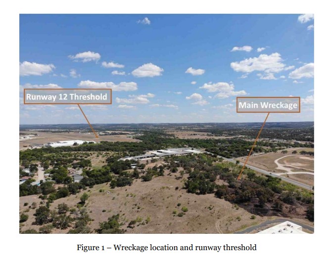
The airplane came to rest at an elevation of about 1,600 ft on the slope of a hill, about 4,200 ft beyond the runway 12 threshold, and 20° offset the runway centerline (figure 1). The first identified point of impact was a cleanly cut swath of tree branches and limbs, at an angle of 70° relative to the horizon. The airplane was located about 30 ft southwest of the swath, at the base of a felled 50-ft tall oak tree. The tree exhibited impact damage along its north face.
The cabin skins were consumed by fire, with only crushed and bent steel frame members remaining. Most of the wings and the tail section were thermally consumed, however, sections of all major airframe components and primary flight controls were found within the immediate wreckage site. The landing gear actuator was located, and its jack screw appeared to be fully retracted, consistent with the landing gear being extended at impact. The trim jack screws in both the moving tail, and elevator cabin trim assemblies exhibited extension dimensions that matched the takeoff pitch trim position.
Aircraft and Owner/Operator Information
Aircraft Make: Mooney
Registration: N4267H
Model/Series: M20J
Aircraft Category: Airplane
Amateur Built:
Operator: On file
Operating Certificate(s) Held: None
Operator Designator Code:
Meteorological Information and Flight Plan
Conditions at Accident Site: VMC
Condition of Light: Day
Observation Facility, Elevation: KERV, 1617 ft msl
Observation Time: 18:15 Local
Distance from Accident Site: 1 Nautical Miles
Temperature/Dew Point: 36°C /11°C
Lowest Cloud Condition: Clear
Wind Speed/Gusts, Direction: 10 knots / , 190°
Lowest Ceiling: None
Visibility: 10 miles
Altimeter Setting: 29.95 inches Hg
Type of Flight Plan Filed: None
Departure Point: Kerrville, TX (ERV)
Destination: Stephenville, TX (SEP)
Wreckage and Impact Information
Crew Injuries: 1 Fatal
Aircraft Damage: Destroyed
Passenger Injuries: 1 Fatal
Aircraft Fire: None
Ground Injuries:
Aircraft Explosion: None
Total Injuries: 2 Fatal
Latitude, Longitude: 29.987047,-99.097337
Those who may have information that might be relevant to the National Transportation Safety Board (NTSB) investigation may contact them by email witness@ntsb.gov, and any friends and family who want to contact investigators about the accident should email assistance@ntsb.gov. You can also call the NTSB Response Operations Center at 844-373-9922 or 202-314-6290.
The woman killed along with the pilot in Saturday’s plane crash near the Kerrville-Kerr County Airport was 47-year-old Ruthy Finch, of Dublin, Erath County, Texas.

Two fatalities have been confirmed following a fiery plane crash that occurred Saturday evening near the Kerrville-Kerr County Airport.
According to reports by the Federal Aviation Administration, the pilot and a passenger were killed when the aircraft crashed under unknown circumstances and caught fire.
“A Mooney M20J 201 crashed after departing from Kerrville Municipal Airport/Louis Schreiner Field in Kerrville, Texas, around 6:30 p.m. local time Saturday. Two people were on board. The FAA and the National Transportation Safety Board will investigate. The NTSB will be in charge of the investigation and will provide additional updates,” an FAA spokesperson said.
According to Kerrville Fire Department Chief Eric Maloney, the call was received by his department at 6:27 p.m. reporting a plane crash west of the airport off Peterson Farm Road.
At the time of the call, one fatality was confirmed and a large, fast-moving brush fire was fully engaged.
“The accident was 50 yards east of OLH, (Our Lady of the Hills College Prep) with the brush fire moving toward the school,” Maloney said. “The brush fire was ignited from the crash and the aircraft fuel.”
Maloney said KFD Engine 1 was first to arrive and was able to connect to a fire hydrant near the head of the fire to establish a quick attack with “handlines and the master stream to knock down the fire from making forward progress toward the school.”
A second engine was also dispatched to make access to the aircraft and extinguish the fire, Maloney said.
“At that time, we did identify there was a second fatality in the aircraft,” Maloney said.
Maloney said mutual aid was requested for brush trucks from the Center Point and Turtle Creek volunteer fire departments.
“Approximately, five acres burned, but no structures were damaged from the brush fire,” Maloney said. “The quick actions of KFD in coordination with our VFDs allowed us to contain the brush fire and stop it from spreading to the school or surrounding acreage of high grass and brush.”
Maloney said KFD worked in coordination with FAA and the Department of Public Safety to assist in extricating the victims from the wreckage.
According to a spokesperson for the National Transportation Safety Board, a preliminary investigation into the cause of the crash will be complete within 12 days. The final report will take approximately 12-18 months, he said.
The identities of the victims have not yet been released, however, the plane is registered to GMT Enterprises, LLC, of Stephenville, Texas, owned by Greg Thompson.
A social media post by the Stephenville Texas Area Pilots and Aviation Enthusiasts identified Thompson as one of the victims.
Aircraft crashed under unknown circumstances and caught on fire.
Date: 25-JUN-22
Time: 23:23:00Z
Regis#: N4267H
Aircraft Make: MOONEY
Aircraft Model: M20J
Event Type: ACCIDENT
Highest Injury: FATAL
Total Fatal: 2
Flight Crew: 1 fatal
Pax: 1 fatal
Aircraft Missing: No
Damage: DESTROYED
Activity: PERSONAL
Flight Phase: INITIAL CLIMB (ICL)
Operation: 91
City: KERRVILLE
State: TEXAS


METARs:
ReplyDeleteKERV 252335Z AUTO 15011KT 10SM CLR 36/11 A2995
KERV 252315Z AUTO 19010KT 10SM CLR 36/11 A2995
This was the airplane's first flight after an Annual inspection. It sat at the airport for a couple months prior to flying, so I'm curious if this might be fuel contamination if it sat outside in rain.
ReplyDeleteThere is local speculation that they experienced partial power loss after takeoff and were trying to return to the airport, but that is purely speculation.