
The National Transportation Safety Board traveled to the scene of this accident.
Additional Participating Entities:
Federal Aviation Administration / Flight Standards District Office; Portland, Oregon
Textron Aviation; Wichita, Kansas


Location: Vancouver, Washington
Accident Number: WPR22FA235
Date and Time: June 28, 2022, 07:40 Local
Registration: N444PM
Aircraft: Beech V35B
Injuries: 1 Fatal
Flight Conducted Under: Part 91: General aviation - Personal
On June 28, 2022, about 0740 Pacific daylight time, a Beechcraft V35B, N444PM, was destroyed when it was involved in an accident near Vancouver, Washington. The pilot was fatally injured. The airplane was operated as a Title 14 Code of Federal Regulations Part 91 personal flight.
According to preliminary automatic dependent surveillance-broadcast (ADS-B) data from the Federal Aviation Administration, the airplane departed Pearson Municipal Airport (VUO), Vancouver, Washington at 0723 on an easterly heading and was in contact with air traffic control. At 0926, the pilot informed air traffic control that he was going to “circle back” due to clouds. When the controller asked
for the pilot’s intentions, the pilot stated that he was going to fly to Vancouver Lake and lose some altitude and “see if this clears.” For the next 2-3 minutes the pilot and air traffic controller attempted to troubleshoot a transponder issue with the accident airplane. During this time, the pilot continued to fly northwest. At 0730 the controller asked the pilot to update him on his intentions and the pilot responded that he was “wondering about the weather…thought it was 4,000 ft, but it’s a lot lower than that.” The controller then asked the pilot to update him with his intentions when he was able to. The pilot requested meteorological information from the controller who offered to send him to approach control. After the pilot accepted his offer, the controller provided the radio frequency for approach control and then gave him a report of another aircraft in his area. The pilot replied to the controller that he was looking for the aircraft.
At 0734, the controller discovered the pilot was not in contact with approach control. He contacted the pilot and informed him that he was still with Portland tower. During this time, the pilot was tracking southbound over Vancouver Lake, approximately 4 nm from Pearson Airport. The pilot then informed the controller that he was going to return to Pearson. The controller asked if he had the airport in sight and the pilot acknowledged that he did. At this point, the controller informed the pilot that radar services were terminated and instructed him to squawk VFR and change to the airport’s common traffic advisory frequency (CTAF).
At 0735, the pilot announced that he was entering the downwind leg of the airport traffic pattern for Pearson over the airport’s CTAF radio frequency. Approximately 1 minute later the pilot announced that he was on the downwind leg, which was his final radio transmission. The airplane turned onto the base leg of the airport traffic pattern about 0736 and maintained a southerly heading.
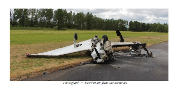
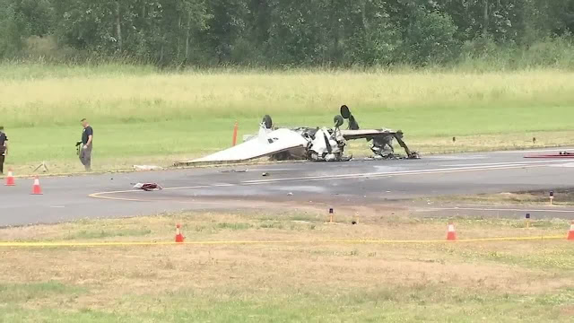
Surveillance video captured the airplane’s final seconds of flight before its impact with the ground. The airplane came into view in a slight right wing low attitude. In the two seconds that followed, the airplane’s right bank angle increased as it descended rapidly towards the ground. The airplane’s right wing impacted the ground first in a near 90° attitude immediately followed by the nose as it burst into flames. The airplane slid inverted for several seconds along the displaced threshold towards runway 26.
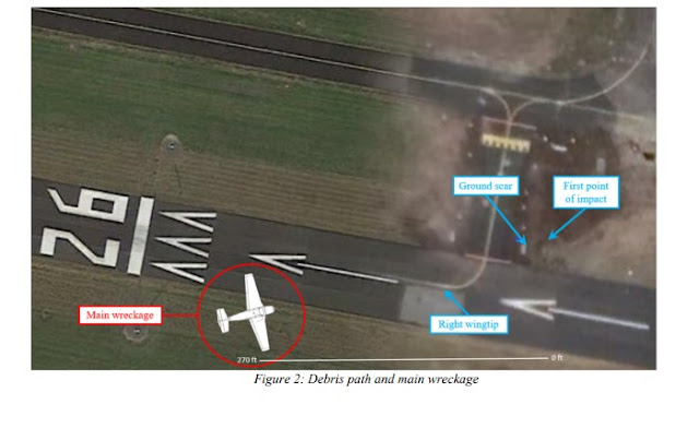
The airplane came to rest inverted on a heading of about 038° magnetic about 120 ft east of the runway 26 numbers. All four corners of the airplane were accounted for at the accident site. The first point of impact (FPI) was marked by a 20 inch long depression about 270 ft northeast of the main wreckage and adjacent to the displaced threshold for runway 26. A second ground scar was observed adjacent to
taxiway A2 about 10 ft forward of the FPI and measured 30 inches long. The second ground scar was collocated with a broken airport taxi light. A debris field was oriented on a heading of 255° magnetic and was comprised of plexiglass and fragments of airframe skin. The right wingtip was located in the debris field about 90 ft from the main wreckage.


Aircraft and Owner/Operator Information
Aircraft Make: Beech
Registration: N444PM
Model/Series: V35B
Aircraft Category: Airplane
Amateur Built:
Operator: On file
Operating Certificate(s) Held: None
Operator Designator Code:
Meteorological Information and Flight Plan
Conditions at Accident Site: VMC
Condition of Light: Day
Observation Facility, Elevation: KVUO, 22 ft msl
Observation Time: 07:43 Local
Distance from Accident Site: 0 Nautical Miles
Temperature/Dew Point: 16°C /10°C
Lowest Cloud Condition: Few / 200 ft AGL
Wind Speed/Gusts, Direction: / ,
Lowest Ceiling:
Visibility: 1.75 miles
Altimeter Setting: 30.13 inches Hg
Type of Flight Plan Filed: None
Departure Point: Vancouver, WA
Destination:
Wreckage and Impact Information
Crew Injuries: 1 Fatal
Aircraft Damage: Destroyed
Passenger Injuries:
Aircraft Fire: On-ground
Ground Injuries:
Aircraft Explosion: None
Total Injuries: 1 Fatal
Latitude, Longitude: 45.620452,-122.65648
Those who may have information that might be relevant to the National Transportation Safety Board (NTSB) investigation may contact them by email witness@ntsb.gov, and any friends and family who want to contact investigators about the accident should email assistance@ntsb.gov. You can also call the NTSB Response Operations Center at 844-373-9922 or 202-314-6290.

In loving memory of Thomas Posey
President and CEO of Lamiglas


Aircraft crashed under unknown circumstances and caught on fire.
Date: 28-JUN-22
Time: 14:40:00Z
Regis#: N444PM
Aircraft Make: BEECH
Aircraft Model: V35
Event Type: ACCIDENT
Highest Injury: FATAL
Total Fatal: 1
Flight Crew: 1 fatal
Pax: 0
Aircraft Missing: No
Damage: UNKNOWN
Activity: PERSONAL
Flight Phase: LANDING (LDG)
Operation: 91
City: VANCOUVER
State: WASHINGTON


The pilot killed June 28 when his small plane crashed at Vancouver’s Pearson Field was publicly identified Tuesday as business executive Thomas M. Posey.
Posey, 64, of Vancouver, died of blunt force and thermal injuries, according to the Clark County Medical Examiner’s Office. His death was ruled an accident.
Posey was the president and CEO of Lamiglas, a Woodland company that manufactures high-tech fishing rods and equipment.
In a Facebook post, Jose Ruelas, operations manager and vice president of Lamiglas, spoke of how he met Posey and became his friend and business partner.
He recalled their travels together — to Mexico and New York — and described Posey as “one of a kind,” adding that “his laugh was something special.”
“Tom you taught me a lot. Thank you for allowing me to be part of this company. I thought being a partner with you was going to be forever. I didn’t know that I was gonna have to do this on my own,” Ruelas wrote. “Fly high In the skies buddy; you will be missed.”
The crash was reported at about 7:40 a.m. The single-engine plane, a Beechcraft 35 Bonanza, caught fire on impact. The Vancouver Fire Department extinguished the fire and confirmed the aircraft’s only occupant had died.
Just before the crash, Posey apparently made brief emergency contact with flight controllers at nearby Portland International Airport, according to emergency radio traffic monitored at The Columbian. Pearson, a general aviation airport, does not have a control tower.
The plane took off from Pearson Field at 7:24 a.m. and crashed at 7:37 a.m., according to FlightAware, a website which tracks aircraft and flight data.
After taking off to the east, the plane reached an altitude of 3,200 feet as it banked west. Then, the plane descended to 900 feet. It circled back toward the airport and remained at a low altitude until it crashed.
The Federal Aviation Administration and the National Transportation Safety Board are investigating the crash.


METARs:
ReplyDeleteKVUO 281435Z AUTO 16005KT 10SM CLR 15/10 A3013
KVUO 281440Z AUTO 16005KT 5SM HZ CLR 16/10 A3013
Track (zoomed to last portion captured):
https://globe.adsbexchange.com/?icao=a55aca&lat=45.625&lon=-122.658&zoom=14.3&showTrace=2022-06-28&leg=2&trackLabels
That seems odd. At one point he was at 3100', but continued flying away form the airport in a descent, presumably after experiencing an issue.
DeleteListening to the ATC recording, it sounded like his transponder was not squawking correctly and the weather was lower than he expected.
DeleteSome have suggested fog/haze as a factor when looking at Metar history. Given 6 point temp/dewpoint spread and wind speed that is very unlikely. What is probable when looking at times, geometry of airport, and wind direction is that ASOS was picking up smoke from the post impact fire.
ReplyDeleteLocal area can get fog as today there is a 4 to 5 point temperature differential however fog
DeleteGlimpses of sky condition can be seen in a news video of responders working the scene. No obvious indication of low vis conditions there unless fog/haze cleared up while the responders were working:
Deletehttps://www.kptv.com/2022/06/28/pilot-killed-small-plane-crash-pearson-field-airport-vancouver/
Comparing the impact mark and wreckage location from stop frame at 0:50 in the kptv.com news video to ADS-B track data shows that the final position captured at 14:37:34Z is located about 100 feet before impact.
DeleteHigh bank angle turn was required to get aligned with the runway when it was reached. Correction of ADS-B baro altitude for local altimeter adds 210 feet to the captured altitudes, RWY26 elevation is 22 feet MSL.
Track, focused on last:
https://globe.adsbexchange.com/?icao=a55aca&lat=45.620&lon=-122.652&zoom=18.2&showTrace=2022-06-28&leg=2&trackLabels
Visibility was not great, but I do not think it was a factor. Shortly after impact an airliner departing PDX and overflying VUO called out the crash to PDX tower but the tower had already seen / suspected it had crashed. A bit later, the tower and another departing airliner further relayed and discussed the exact crash location and smoke plume. So both airliners had eyes on the crash site.
DeleteThe pilot originally intended to depart to the east so he obtained a squawk code from PDX to transition their Charlie. He climbed straight out but due to low ceiling had a change of plans and turned back to the west, evidently looking for a hole to get on top.
Yes, he was fiddling with the the transponder because he was in PDX Charlie and they were trying to ID him, but by the time of the crash he was out of Charlie so PDX didn’t need to ID him anymore and he shouldn’t have been playing with the transponder and nobody was asking him to cycle the transponder or ID anymore.
He then went west of the field to Vancouver lake and descended to get under the clouds. at 1000 MSL he was now under the PDX Charlie and in the Pearson cutout. He entered and made normal CTAF calls for downwind. The ADS-B data frequently cuts out while in base, but his downwind looked appropriate. I see nothing to indicate his base to final turn was overly tight, and that turn would have been much further to the east and well off airport property.
Here is my 2 cents—
Pearson has a very long (760 ft) displaced threshold. I have seen many a pilot drag their plane to the touchdown because it is very easy to fly the pattern looking at the *whole* runway and then wind up being very low over the end of the field and then have to drag it to the threshold. 760 feet is a very long ways to drag an aircraft. Add to that any bit of surprise winds from the south or SW, and the space between the fence and the threshold becomes a dangerous place. Winds at Pearson frequently gust to 15 or 20. Based on the crash location between the end of the runway and the threshold, I would not be surprised if he simply lost track of airspeed while stretching it to the threshold. Then stall and spin to the left.
Pearson has a dozen factors that make it extremely dangerous, this 760ft displaced threshold is just one of the minor ones
Interesting perspective about changing winds and dragging into RWY26 as rationale for making a Bob Hoover turn inside the fence instead of lining up for final from further out. Looking at other aircraft approaches to see if this is typical for south wind swaps, found C150 N19298 in varying winds shooting four approaches on 23 June. No Bob Hoover turn in that example.
DeleteFor comparison, here are the 23 June winds during that four landing interval and that C150's track while experiencing them:
KVUO 232155Z AUTO 32008KT 10SM CLR 23/04 A3010
KVUO 232200Z AUTO 01005KT 10SM CLR 23/05 A3010
KVUO 232205Z AUTO 35009KT 10SM CLR 23/04 A3010
KVUO 232210Z AUTO 31009KT 10SM CLR 23/04 A3009
KVUO 232215Z AUTO 01005KT 10SM CLR 23/05 A3009
KVUO 232220Z AUTO 36005KT 10SM CLR 23/06 A3009
C150 N19298 track, 23 June:
https://globe.adsbexchange.com/?icao=a1734d&lat=45.623&lon=-122.662&zoom=13.8&showTrace=2022-06-23&trackLabels
Seems like if a C150 in wind that swaps to south can make it there, you could do the same in a Bo or Debonair (apologies to Frank Sinatra) without opting for an inside the fence turn.
Who said anything about doing a sharp turn inside the fence?
DeletePlanes do need to keep a tight and low pattern to avoid PDX Charlie, but nothing unreasonable. This pilot frequently did pattern work at VUO and typically flew a normal pattern. Landing at VUO requires a bit of finesse and many things that can be uncomfortable for the first few times but this pilot was familiar with VUO.
Any single can safely land and TO from VUO, so it is asinine to apply other planes to the situation when, unless there is a mechanical issue, it is nearly always the pilot or weather that causes accidents.
Sharp turn right turn is evident in ADS-B. Did you not see it?
DeleteHere it is, again:
https://globe.adsbexchange.com/?icao=a55aca&lat=45.621&lon=-122.652&zoom=16.2&showTrace=2022-06-28&leg=2&trackLabels
Came to the runway on almost perpendicular heading, low, slow, banked hard, impacted inverted within 100 feet of last ADS-B data point.
Deletebased on the ADSB data it looks as though the mishap pilot was never on a downwind and flew directly to base. The data also shows 61 knots at 100 ft.
DeleteThe steep turn required to turn final along with the flaps being retracted and the low airspeed indicates a stall, which I think we can agree on..
The FlightAware ADS-B data makes it look like there was an actual downwind entered, but the ADSBExchange data has a lot of inferred track but then picks back up at the end. Which is correct? Are they both from the same ADSB source or is one terminal radar or something?
DeleteLooking at the ADSBExchange, I can only imagine that he must have lost site of the runway or something, how else could somebody completely lose situational awareness that bad? It looks like he thought he was on final but still 90 degrees to the runway. Right before the crash he was flying directly towards the edge of pdx airspace with only, what, 1000 -1500 ft between the Pearson runway and the start of Portland airspace? At that point his choices were to try a sharp turn or encroach unannounced into the class C. He would have been much lower than departing PDX traffic so not much collision risk, but man what a tough spot to be in.
Where do you get archived METARs? At some point that morning, VUO was low IFR with 3/4 mile visibility
ADS-B data transmitted from aircraft is captured by ground receivers, results vary. It's not whether FA or AdsbXc is right, just a matter of what the receivers feeding them have captured.
DeleteYour point about weather degrading shows up in the archive data. The pilot was likely trying to beat what was developing and get back in at the 14:37 Z crash time. Here is the progression, by time:
KVUO 281435Z AUTO 16005KT 10SM CLR 15/10 A3013
-- crashed at 14:37:32 --
KVUO 281440Z AUTO 16005KT 5SM HZ CLR 16/10 A3013
KVUO 281445Z AUTO VRB05KT 3/4SM HZ VV002 16/10 A3013 RMK AO2 VIS M1/4V5 T01560100,M
KVUO 281445Z AUTO 15005KT 1SM HZ VV002 16/10 A3013 RMK T01600100 VRB05KT MADISHF,M
KVUO 281450Z AUTO 14005KT 1/2SM HZ SCT002 SCT039 16/10 A3013 RMK T01600100 MADISHF,M
KVUO 281453Z AUTO 14006KT 1/2SM HZ FEW002 SCT039 16/10 A3013 RMK AO2 VIS M1/4V5 SLP204 T01560100 51019,M
Full Archive METAR/AWOS data is available from:
https://mesonet.agron.iastate.edu/request/download.phtml?network=WA_ASOS
Takes a bit of familiarization to use, but the basics are:
- Use select network to pick the state (url above opens to WA)
- Highlight airport you want in station select box
- Click "add selected"
- Select start date as UTC day of interest
- Select end date as one day later
- No need to change anything else, just click "Get Data"
Doing that for this accident generates that days archive data:
https://mesonet.agron.iastate.edu/cgi-bin/request/asos.py?station=VUO&data=all&year1=2022&month1=6&day1=28&year2=2022&month2=6&day2=29&tz=Etc%2FUTC&format=onlycomma&latlon=no&elev=no&missing=M&trace=T&direct=no&report_type=1&report_type=2
As was commented on earlier, I do not believe that weather is going to be a factor in this accident. The haze did not begin until AFTER the crash had taken place and lasted just 15 minutes or so. A 6-degree temp/dew point spread and 6 kt wind is not a fog maker. The crash was just a few hundred feet up wind from the ASOS. The haze was undoubtedly smoke from the post-crash fire detected by the sensor. The mystery of this accident is figuring out why such a short approach was attempted. What made the pilot believe that he needed to get down so fast?
ReplyDeleteGood catch on the ASOS station location relative to the accident and wind direction. Wind from 140 to 160 and map image showing the weather instruments next to the wind sock supports that evaluation.
Deletehttps://www.google.com/maps/place/Pearson+Field/@45.620646,-122.6534856,267m/data=!3m1!1e3!4m5!3m4!1s0x5495a8abbd3bb437:0x7b8b3295b7862179!8m2!3d45.6223129!4d-122.6558909
I happened to stop at VUO on my way to work that morning. I was on the field at 8:56 am and had been headed to my hangar. A police unit blocking the open gate near the gas pumps was a tip-off that something was up. I saw and could smell the last of the smoke from the wreckage as I pulled up to the West gate. Visibility on the ground was fine (no fog , no mist) and didn't seem like it would not have been a factor for someone in the pattern. At 9:00 am, It was not good traveling weather but the runway was not obscured.
DeleteListening to the LiveATC again for VUO Advisory (119.0) and PDX TWR (123.77) I strongly suspect that the pilot was having some sort of a medical emergency, or perhaps carbon monoxide exposure. His initial responses to PDX TWR while trying to sort out the transponder issue were not what I’d expect from a pilot of his experience. He then seemed conflicted about going back to VUO for repairs vs proceeding on course. He then flew a very circuitous route to get back VUO. He then failed to respond to a PDX TWR hand off to PDX AP (124.35). Four minutes later he responded to PDX TWR sounding very unsure. He called downwind but not base or final. Finally, he entered into an approach that would only take place if there was an in-flight fire, engine out, or medical emergency. No mention of fire or engine out was made. I hear a pattern of declining decision making.
ReplyDeleteAnother numbskull who shouldn't have a license.
ReplyDeleteAnother trust fund member of a family owned business that has never had to find their own job or career, and spends their time spending daddy’s money on toys without getting or maintaining proficiency. Another perfectly good Bonanza destroyed by immature rich kiddies (of all ages).
ReplyDeleteDuring the last moments of the flight, the aircraft attitude finished straight and level over the runway after rolling out from base leg. There were no further inputs as the aircraft banked slowly and descended into the runway. Clearly, the pilot lost consciousness after rollout from base leg, a higher stress moment of any flight. Heart attacks are #1 cause of sudden, loss of consciousness.
ReplyDelete