
The National Transportation Safety Board did not travel to the scene of this accident.
Additional Participating Entity:
Federal Aviation Administration / Flight Standards District Office; Dallas, Texas
Investigation Docket - National Transportation Safety Board:
Location: Woodstock, Texas
Accident Number: CEN22LA133
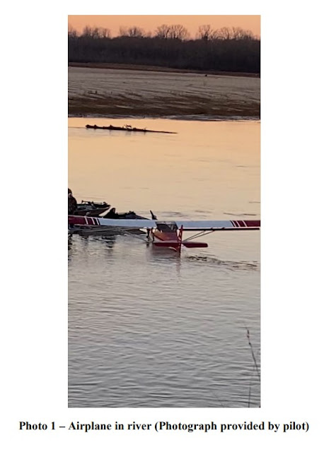
Date and Time: February 27, 2022, 18:00 Local
Registration: N494KF
Aircraft: GOULD PAUL 4-1200
Injuries: 1 None
Flight Conducted Under: Part 91: General aviation - Personal
Aircraft and Owner/Operator Information
Aircraft Make: GOULD PAUL
Registration: N494KF
Model/Series: 4-1200
Aircraft Category: Airplane
Amateur Built:
Operator: On file
Operating Certificate(s) Held: None
Operator Designator Code:
Meteorological Information and Flight Plan
Conditions at Accident Site: VMC
Condition of Light: Dusk
Observation Facility, Elevation: KTXK,361 ft msl
Observation Time: 17:53 Local
Distance from Accident Site: 23 Nautical Miles
Temperature/Dew Point: 12°C /-3°C
Lowest Cloud Condition: Clear
Wind Speed/Gusts, Direction: 4 knots / , 10°
Lowest Ceiling: None
Visibility: 10 miles
Altimeter Setting: 30.31 inches Hg
Type of Flight Plan Filed: None
Departure Point: Woodstock, TX
Destination: Woodstock, TX
Wreckage and Impact Information
Crew Injuries: 1 None
Aircraft Damage: Substantial
Passenger Injuries:
Aircraft Fire: None
Ground Injuries:
Aircraft Explosion: None
Total Injuries: 1 None
Latitude, Longitude: 33.579925,-94.422579 (est)


Missing?
ReplyDeleteBased on proximity t New Boston, likely it was the Red River where there are sandbars that shift daily, even hourly depending on water flow. The Red River creates most of the state border between TX-OK and a small part of southwestern AR. It would not be unusual for the aircraft to have become dislodged and pushed down stream. North Texas recently came out of a nasty winter storm (this area is in northeastern TX) so it would have a lot of water flowing at the time from further west. Those sandbars can be over 1,000' long and the the river 500'-1,000' wide in many areas with a depth in the middle that can approach 30' depending on water volume and speed. The Red River could easily swallow a Kitfox in post-storm flow conditions.
Delete