
The National Transportation Safety Board did not travel to the scene of this accident.
Additional Participating Entities:
Federal Aviation Administration / Flight Standards District Office; Atlanta, Georgia
Textron Aviation; Wichita, Kansas
Flight School of Gwinett Inc
Location: Winder, Georgia
Accident Number: ERA22LA167
Date and Time: March 25, 2022, 10:48 Local
Registration: N62283
Aircraft: Cessna 172P
Injuries: 2 Serious
Flight Conducted Under: Part 91: General aviation - Instructional
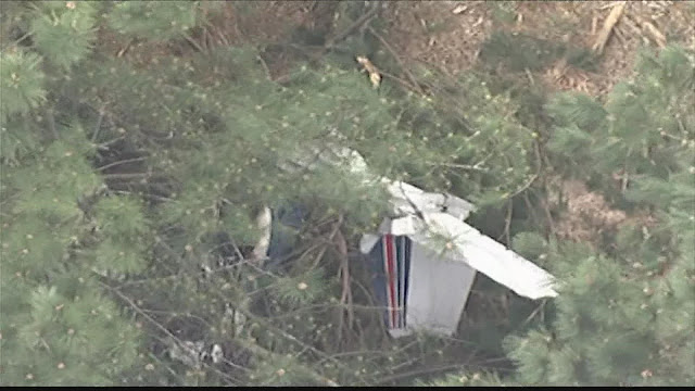
On March 25, 2022, about 1048 eastern daylight time, a Cessna 172, N62283, was destroyed when it was involved in an accident near Winder, Georgia. The flight instructor and student pilot were seriously injured. The airplane was operated as a Title 14 Code of Federal Regulations Part 91 instructional flight.
According to the student pilot, they performed a preflight inspection of the airplane with no anomalies noted. They departed Gwinnett County Airport (LZU), Lawrenceville, Georgia, and flew to Barrow County Airport (WDR), Winder, Georgia, and performed several circuits in the traffic pattern. While on the final approach leg of the traffic patter to runway 31, the student pilot turned the yoke to the right “and felt it give as if a cable had become detached.” The flight instructor took control of the airplane and experienced the same effects; the yoke could be turned in a “complete circle with no response” from the airplane. The airplane veered to the right and descended into trees. A post-impact fire ensued, which consumed the fuselage and wings.
The airplane came to rest about ½-mile from the approach end of runway 31.
The airplane was retained for further examination.
Aircraft and Owner/Operator Information
Aircraft Make: Cessna
Registration: N62283
Model/Series: 172P
Aircraft Category: Airplane
Amateur Built:
Operator:
Operating Certificate(s) Held: Pilot school (141)
Operator Designator Code:
Meteorological Information and Flight Plan
Conditions at Accident Site: VMC
Condition of Light: Day
Observation Facility, Elevation: WDR,943 ft msl
Observation Time: 10:55 Local
Distance from Accident Site: 1 Nautical Miles
Temperature/Dew Point: 15°C /0°C
Lowest Cloud Condition: Clear
Wind Speed/Gusts, Direction: 11 knots / 19 knots, 310°
Lowest Ceiling: None
Visibility: 10 miles
Altimeter Setting: 29.92 inches Hg
Type of Flight Plan Filed: None
Departure Point: Winder, GA
Destination: Winder, GA
Wreckage and Impact Information
Crew Injuries: 1 Serious
Aircraft Damage: Destroyed
Passenger Injuries: 1 Serious
Aircraft Fire: On-ground
Ground Injuries: N/A
Aircraft Explosion: Unknown
Total Injuries: 2 Serious
Latitude, Longitude: 33.980282,-83.650706 (est)
Aircraft experienced engine issues and crashed into a wooded area and caught on fire.
Date: 25-MAR-22
Time: 14:48:00Z
Regis#: N62283
Aircraft Make: CESSNA
Aircraft Model: 172
Event Type: ACCIDENT
Highest Injury: UNKNOWN
Aircraft Missing: No
Damage: DESTROYED
Activity: PERSONAL
Flight Phase: EN ROUTE (ENR)
Operation: 91
City: WINDER
State: GEORGIA

BARROW COUNTY, Georgia — Two people were rushed to the hospital on Friday after a plane crashed in Barrow County.
Barrow County Emergency Management Services told 11Alive the small plane crashed on Giles Road about a mile away from the airport in Winder, Georgia before bursting into flames.
Two people were injured in the incident. One of them was taken to the hospital by ambulance and the other had to be airlifted, according to Barrow EMS.
Authorities have not given an update on their conditions at this time.
Right now, the Federal Aviation Administration is investigating and there are limited details about the crash.


after multiple touch and goes, on final, my take PIC appears to have stalled on attempted right departure go around .4 nm from threshold Rwy 31.
ReplyDeleteTime: 14:47:24 Z
Groundspeed: 71 kt
Baro. Altitude: ▲ 900 ft
Geom. Altitude: 825 ft
Vert. Rate: 256 ft/min
Track: 38.2°
Pos.: 33.980°, -83.652°