
The National Transportation Safety Board traveled to the scene of this accident.
Additional Participating Entities:
Federal Aviation Administration / Flight Standards District Office; Cleveland, Ohio
Piper Aircraft; Vero Beach, Florida
Lycoming Engines; Williamsport, Pennsylvania
Seneca County Sheriff's Office -
Location: Fostoria, Ohio
Accident Number: CEN22FA131
Date and Time: February 22, 2022, 22:41 Local
Registration: N3952W
Aircraft: Piper PA-32-260
Injuries: 2 Fatal
Flight Conducted Under: Part 91: General aviation - Personal
On February 22, 2022, about 2241 eastern standard time, a Piper PA32 airplane, N3952W, was destroyed when it was involved in an accident near Fostoria, Ohio. The pilot and passenger were fatally injured. The airplane was operated as a Title 14 Code of Federal Regulations (CFR) Part 91 personal flight.
The flight was conducted as an instrument flight rules (IFR) flight from Effingham County Memorial Airport (1H2), Effingham, Illinois, to Findlay Airport (FDY), Findlay, Ohio. The filed IFR flight plan stipulated a cruise altitude of 9,000 ft mean sea level (MSL), an estimated time enroute of 1 hour and 28 minutes, and 4 hours of fuel on board.
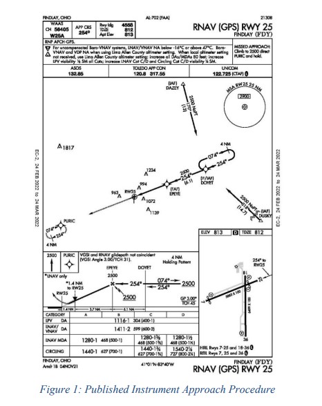
A review of archived Federal Aviation Administration (FAA) automatic dependent surveillance broadcast (ADS-B) data revealed that the airplane departed 1H2 about 1956 central standard time, climbed to about 7,000 ft MSL, and proceeded on a relatively direct track toward DOYET, the initial approach fix for the RNAV/GPS runway 25 instrument approach, as shown in Figure 1.
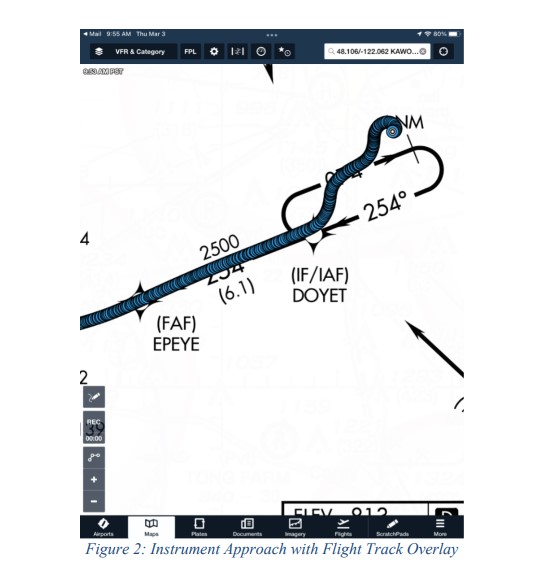
After passing DOYET, the airplane turned left about 45°, consistent with a teardrop entry into the procedure turn, before it turned back right, and paralleled the inbound course of the procedure turn. About 4 nautical miles (nm) from DOYET, the airplane turned right, as if to intercept the inbound course, but descended rapidly in a spiral and impacted terrain on a 340° heading (see Figure 2).
A review of commercially available communications data revealed that the last confirmed communication between the accident airplane and air traffic control (ATC) took place when ATC instructed the pilot to cross DOYET at or above 3,000 ft and cleared them for the RNAV runway 25 approach, to which the pilot read back the clearance and altitude restriction. Shortly thereafter, ATC attempted to contact the pilot and subsequently issued a low altitude alert, but no reply or acknowledgement was received.
A witness inside their residence described hearing an airplane low near their house. They described the noise as a loud engine or high RPM engine followed by silence. Another nearby witness saw the lights of the airplane but did not hear anything because they were in a car with the radio on. They said that at first sight, the airplane was estimated between 300 and 500 ft above ground level (AGL). When they lost sight of the airplane as it descended behind houses, they estimated the altitude as between 150 and 250 ft AGL.
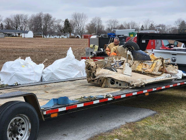
The airplane first impacted a field in a relatively flat attitude and continued the 340° track into the trees where it collided with multiple trees and became highly fragmented. Flight control continuity could not be established due to the highly fragmented nature of the wreckage, but all lengths of control cables were accounted for at the accident location. All major pieces of the airplane were observed at the accident location.
A detailed examination is pending.
Aircraft and Owner/Operator Information
Aircraft Make: Piper
Registration: N3952W
Model/Series: PA-32-260
Aircraft Category: Airplane
Amateur Built:
Operator: On file
Operating Certificate(s) Held: None
Operator Designator Code:
Meteorological Information and Flight Plan
Conditions at Accident Site: IMC
Condition of Light: Night
Observation Facility, Elevation: KFDY,812 ft msl
Observation Time: 03:53 Local
Distance from Accident Site: 15 Nautical Miles
Temperature/Dew Point: 11°C /7°C
Lowest Cloud Condition:
Wind Speed/Gusts, Direction: 11 knots / , 230°
Lowest Ceiling: Broken / 8000 ft AGL
Visibility: 10 miles
Altimeter Setting: 29.92 inches Hg
Type of Flight Plan Filed: IFR
Departure Point: Effingham, IL (1H2)
Destination: Findlay, OH (FDY)
Wreckage and Impact Information
Crew Injuries: 1 Fatal
Aircraft Damage: Destroyed
Passenger Injuries: 1 Fatal
Aircraft Fire: None
Ground Injuries:
Aircraft Explosion: None
Total Injuries: 2 Fatal
Latitude, Longitude: 41.14139,-83.377247
Those who may have information that might be relevant to the National Transportation Safety Board (NTSB) investigation may contact them by email witness@ntsb.gov, and any friends and family who want to contact investigators about the accident should email assistance@ntsb.gov. You can also call the NTSB Response Operations Center at 844-373-9922 or 202-314-6290.
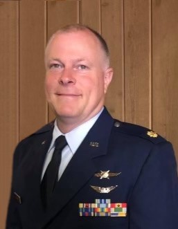
Major Michael David Wright
January 26, 1971 ~ February 22, 2022 (age 51)
~
Major Michael David Wright, age 51, of Casey, IL received his eternal wings at 10:47 p.m. on Tuesday, February 22, 2022, in Loudon Twp., Seneca County, OH, the result of an airplane crash. He was born January 26, 1971, in Wichita Falls, TX, the son of Lt. Col. Larry Othello “Casey” Wright and Sandra Kae Scott Wright. On September 5, 1998, he married the love of his life Laura Dawn French in Casey, IL.
Survivors include his wife of twenty-three years, Laura Wright of Casey, IL; children, Britney Wright and Brian Wright of Casey, IL; mother, Sandra Faust (Jon) of Peru, IN; brother, Charles L. Wright (Dawn) of Mishawaka, IN; sister, Deborah Wright of Mishawaka, IN; stepbrothers, Melvin Gray (Amy) of Hazel Dell, IL; Stephen Gray (Stephanie) of Casey, IL; Jon W. Faust of Indianapolis, IN; Robert Faust of Mobile, AL; stepsister, Jodi Faust of Peru, IN; father-in-law, Steven French (Sandy) of Newton, IL; mother-in-law, Becky Groves of Dieterich, IL; brothers-in-law, Michael French (Sarah) of Dieterich, IL; Shawn Klier (Tracy) of Chandler, AZ; Shannon Klier (April) of Midland, TX; and Shane Klier (Rhiannon) of Edmund, OK; sister-in-law, Pamela Hartke (Caleb) of Dieterich, IL; Big Brother, John Mongosa (Lois) of Peru, IN; uncle, aunts, nephews, nieces, cousins, his military and church families and many friends. He was preceded in death by his father and stepmother, Larry and Karen Wright, and his grandparents.
Michael was a 1989 graduate of Casey-Westfield High School and a 2003 graduate of Indiana State University. He proudly served his country for 31 years in both the Army and Air Force. While in the service, Michael had duties as an F-16 jet engine mechanic, Blackhawk helicopter pilot, and Communications Officer. Most of his years of service were spent with the 181st Communication Flight, 181st Intelligence Wing at Hulman Field Air National Guard Base in Terre Haute, IN. He was currently a member of the USAF Reserve 375th Communication Squadron stationed at Scott Air Force Base in Illinois.
Michael loved spending time with his family, watching his kids play sports, traveling, and inventing. As an entrepreneur, Michael created several companies. High Flight, a corporate flying service, was the focal point of his career for the past 17 years. Michael had a love for flying and teaching. He was always thrilled to take people to the skies for the first time and to share his love of aviation with others; because it was never a “job” for him - it was his passion.
Visitation will be held from 4-7 p.m. on Wednesday, March 2, 2022, at the Casey United Methodist Church, 703 N. Central Ave., Casey, IL 62420.
Funeral services will be conducted at 10:30 a.m. on Thursday, March 3, 2022, at Casey United Methodist Church with Rev. Dr. Joe Richard officiating. Burial will follow at the Casey Cumberland Cemetery, Casey, IL, with graveside military honors by Scott Air Force Base Honor Guard, Terre Haute Air National Guard, Casey VFW, and Martinsville American Legion.
Memorial donations may be made to a college fund for his children to Laura Wright, c/o Markwell Funeral Home, PO Box 175, Casey, IL 62420.
To view the full obituary, send a condolence message, light a candle, or post photos, visit www.markwellfuneralhome.com. Markwell Funeral Home of Casey, IL is in charge of the arrangements.
Norwalk – The Norwalk Post of the Ohio State Highway Patrol is investigating a fatal plane crash that occurred on February 22, 2022 at 10:47 PM. The crash occurred approximately 2 miles east of the City of Fostoria near Crestview Drive in Loudon Township, Seneca County.
Deputies from the Seneca County Sheriff’s Office and Officers from the Fostoria Police Department responded to a report of a possible plane crash near Crestview Drive in Loudon Township. Deputies searched and located the crashed plane in a wooded area north of Crestview Drive. Two deceased victims were located on scene.
The pilot was identified as Shane Alan Halbrook, age 59, of Avon Indiana. The co-pilot was identified as Michael D. Wright, age 51, of Casey Illinois. The plane was identified as a Piper Saratoga single engine plane. The tail number on the plane was N3952W. The cause of the crash remains under investigation.
Assisting on scene were Seneca County Sheriff’s Office, Fostoria Police, Bascom Fire, Seneca County EMS, and the Seneca County Coroner’s Office.
*****
I want to thank all of the agencies who helped with the crash site last night. It was not an easy scene to get to nor was it an easy scene to deal with once found.
I want to thank the Ohio State Patrol for taking the investigation and securing the scene overnight as we only had two deputies working the county and had deputies overshift to help search.
Our prayers and condolences go out to the families of the two victims.
-Sheriff Stevens


"Flight data shows the plane left Effingham Illinois just before 9pm eastern time and the final destination was supposed to be Findlay. According to data from Flight Aware, the plane went right past the airport in Findlay and ended up in Fostoria very close to a neighborhood.
ReplyDeleteThe pilot did appear ready to land in Findlay but something appears to have happened because minutes later air traffic control noticed the plane losing altitude" 13ABC
Aircraft picked up ice on descent, entered the cold front squall line,
ReplyDeleteoverflew the procedure turn, stalled entering the procedural turn for the rnav approach. The flight track after Findley indicates trouble holding a heading, 50kt winds didn't help.
Local weatherunderground surface weather station @ Elev 856 ft, 41.05 °N, 83.44 °W, BigLick Acres - KOHALVAD2
ReplyDelete10:28 PM 42.4 °F, dew pt 35.0 °F, 77 %, West 19.0 mph, guests 30.0 mph, 29.96 in
IIRC no PIREPs were issued or available
ReplyDeleteA commercial pilot & ATP passenger wouldn't likely overfly the field on a known route they've done a bunch of times prior. I'd expect something like carbon monoxide from the heater to be a potential culprit.
ReplyDeleteThat could explain it, especially if one was catching some z's.
DeleteYou would think though, it would motor on for another hour if the autopilot was engaged.
ATC Audio suggests they were alert and coherent with a garbled frantic keying of the mike prior to losing radar contact
DeleteSomething seems amiss about their understanding of where they were. They were at almost 5000' MSL when they passed over KFDY, squawking 1107 and had filed for KFDY as destination.
Deletehttps://globe.adsbexchange.com/?icao=a4980f&lat=40.941&lon=-83.837&zoom=9.2&showTrace=2022-02-23&trackLabels
https://flightaware.com/live/flight/N3952W/history/20220223/0155Z/1H2/KFDY
NTSB preliminary is out
ReplyDeleteIce and 50 knot winds aloft in night IFR conditions in a single engine reciprocating engine aircraft without anti-ice or ice prevention is begging the question: Why? What is so important that requires pilots to roll the dice which are loaded against them? Why? A Piper Saratoga is not the aircraft of choice for known or forecast icing and moderate or worse turbulence. STAY HOME or in a HOTEL! Watch Juan Brown and Dan Gryder on YouTube. Fly when the weather improves.
ReplyDeleteWill the final report be released soon?
ReplyDeleteThe final will probably be available in about nine months.
ReplyDeleteFinal NTSB Report: Night IFR spatial disorientation during procedure turn led to stall/spin with sedating drugs detected that may have contributed.
ReplyDelete