
The National Transportation Safety Board traveled to the scene of this accident.
Additional Participating Entities:
Federal Aviation Administration / Flight Standards District Office; Indianapolis, Indiana
Piper Aircraft Co; Vero Beach, Florida
Annies Aviation LLC
Location: Bloomington, Indiana
Accident Number: CEN22FA080
Date and Time: December 17, 2021, 20:08 Local
Registration: N5677V
Aircraft: Piper PA-32R-300
Injuries: 1 Fatal
Flight Conducted Under: Part 91: General aviation - Personal
On December 17, 2021, at 2008 eastern standard time (est), a Piper PA-32R-300 airplane, N5677V, was destroyed when it was involved in an accident near the Monroe County Airport (BMG), Bloomington, Indiana. The pilot was fatally injured. The airplane was operated as a Title 14 Code of Federal Regulations Part 91 personal flight.
The pilot initially departed Chicago Executive Airport (PWK) at 1618 central standard time enroute to Indianapolis Metro Airport (UMP), arriving at 1844 est. He subsequently departed UMP at 1925 est with an intended destination of BMG. After departure from UMP, the airplane proceeded on course to the southwest and then to the south and reached an altitude of 3,900 ft mean sea level (msl). The pilot was provided radar vectors and ultimately cleared for the Instrument Landing System (ILS) Runway 35 approach into BMG.
Automatic Dependent Surveillance – Broadcast (ADS-B) data depicted the airplane tracking inbound along the ILS 35 final approach course. The airplane passed the final approach fix at 2006:58, and averaged a descent rate of about 700 fpm during the initial portion of the final approach segment. About 2008:15, the airplane entered a right turn approximately 2.25 miles from the runway. The final data point was recorded at 2008:30.
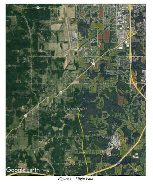
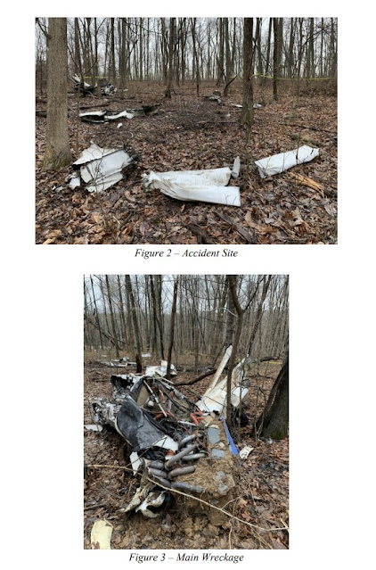
The airplane impacted a wooded hillside about 2.0 miles south of the runway on an easterly heading. The initial tree impact was about 112 ft from the final ADS-B data point. Multiple tree breaks were observed along the impact path. One tree strike appeared consistent with a propeller blade cut. The fuselage came to rest about 300 ft from the initial tree strike and was partially consumed by a postimpact fire. The propeller hub was fractured consistent with overstress, and both propeller blades were liberated and located at the accident site. The engine was partially separated and located in position forward of the firewall. The wings and empennage were fragmented. All airframe structure, including the flight controls, were located within the debris field.
Aircraft and Owner/Operator Information
Aircraft Make: Piper
Registration: N5677V
Model/Series: PA-32R-300
Aircraft Category: Airplane
Amateur Built:
Operator: On file
Operating Certificate(s) Held: None
Operator Designator Code:
Meteorological Information and Flight Plan
Conditions at Accident Site: IMC
Condition of Light: Night
Observation Facility, Elevation: KBMG,846 ft msl
Observation Time: 20:11 Local
Distance from Accident Site: 2 Nautical Miles
Temperature/Dew Point: 4°C /3°C
Lowest Cloud Condition:
Wind Speed/Gusts, Direction: 8 knots / , 130°
Lowest Ceiling: Overcast / 500 ft AGL
Visibility: 4 miles
Altimeter Setting: 30.06 inches Hg
Type of Flight Plan Filed: IFR
Departure Point: Indianapolis, IN (UMP)
Destination: Bloomington, IN (BMG)
Wreckage and Impact Information
Crew Injuries: 1 Fatal
Aircraft Damage: Destroyed
Passenger Injuries: N/A
Aircraft Fire: On-ground
Ground Injuries: N/A
Aircraft Explosion: None
Total Injuries: 1 Fatal
Latitude, Longitude: 39.108858,-86.604478

~
Adam Wade Clark, 40, of Bloomington passed away Friday, December 17, 2021.
Born, June 20, 1981 in Columbus, IN; he was the son of Paul M. Clark and Lorena M. (Mathis) Clark.
Adam loved to fly and would say there is nothing better than being in the sky.
He is survived by his immediate family, his wife, Amber, and their children, Amelia, Annie, stepson Braden, and his parents Lorena M. (Mathis) Clark of Columbus, Indiana, and Paul M. Clark (Patsy Clark) of Elmore City, Oklahoma.
A graveside service will be Thursday, January 6, 2022 at Clear Creek Cemetery in Bloomington.
Allen Funeral Home and Crematory, 4155 S. Old State Rd. 37 in Bloomington have been entrusted with arrangements.
Adam Wade Clark of Bloomington has been identified as the man killed Friday night in a small plane crash south of the Monroe County Airport.
Clark was 40 years old. The Piper PA-32R-300 Cherokee Lane he was flying from Indianapolis to Bloomington was registered to him through an LLC called Annie's Aviation LLC.
According to flight records, weather conditions in Bloomington when the 8:10 p.m. crash happened included mist, light rain and fog.
FAA records indicate Clark had flown from Bloomington to Chicago the afternoon of December 16 and was returning to Bloomington the next day, after a stop at Indianapolis Metropolitan Airport in Fishers, when the accident occurred southwest of Bloomington, about 2 miles south of the airport.
The plane crashed in a wooded area near Tower Road on its approach to the airport for landing and caught fire. Flight records indicate he was one minute from the runway.
The National Transportation Safety Board is investigating the crash.
Monroe County Coroner Joani Stalcup said blunt force trauma was the preliminary cause of Clark's death.
Adam Clark was flying home from Chicago and was just a minute away from landing at Monroe County Airport when his small plane went down in woods near Tower Road and burned the night of December 17.
The 40-year-old Bloomington man was alone in the plane and died from blunt-force trauma in the 8:10 p.m. crash.
Clark had stopped mid-trip at Indianapolis Metropolitan Airport in Fishers, and had been back in the air 45 minutes and traveled 63 miles from there when his plane crashed.
Federal Aviation Administration records indicate Clark's pilot certification is valid until 2024.
According to data from the FAA, Clark had flown the plane to Chicago on Thursday, Dec. 16, leaving the Monroe County Airport at 4 p.m. After a stop at the Fishers airport, he continued to Chicago.
The next day, he departed Chicago at 5:18 p.m. Bloomington time, made a brief stop at the Indy Metro airport,
FAA radar images available online show the plane's flight pattern. It had traveled just past the airport, made a turn to the west and then another to the north, and was approaching the airport to land when the plane gained speed and started to lose altitude.
Forty minutes from Fishers, flight records show, the plane was at 2,700 feet and traveling 167 mph. Two minutes later, it was at 2,000 feet and going 153 mph. Then it went off the radar monitor.
Weather indicators compiled by the FAA show it was dark, overcast and misty, with light rain falling, at the time of the crash. Winds were out of the southeast at 10 mph, and visibility was listed at about four miles.
The cloud ceiling was low, and it was about 40 degrees outside with a dew point in the high 30s.


Some KBMG METARS from time period before starting out to after crash:
ReplyDeleteKBMG 180137Z 09006KT 3SM -RA BR OVC004 04/03 A3006
KBMG 180111Z 13008KT 4SM -RA BR OVC005 04/03 A3006
KBMG 180053Z 11008KT 7SM -RA OVC004 04/03 A3008
KBMG 180002Z 11009KT 5SM -RA BR OVC004 04/02 A3008
Track recordings:
https://flightaware.com/live/flight/N5677V
https://globe.adsbexchange.com/?icao=a7444c&lat=39.444&lon=-86.636&zoom=8.7&showTrace=2021-12-18&trackLabels
With the rain, overcast layer and temps slightly above freezing, icing and freezing precipitation was likely. The ADS-B data (which isn't always super accurate) shows an approach that was a bit unstable but nothing terrible until a sudden right roll and rapid descent. The ground speed data during the approach indicates they were nowhere near typical stall speeds. All the evidence has the hallmarks of an icing induced upset and loss of control.
DeleteThe KBMG-Dec-18-2021-0100Z LiveATC tape has the communications with this aircraft. He was cleared onto the ILS 35 approach into KBMG and later contacted tower and was cleared to land. The pilot sounds cheerful and not stressed at all. No mayday call was recorded, nor any calls from the tower or departure wondering why the aircraft never landed.
The ADS-B Track shows it flying on 18-DEC-21, so unless it came back from the dead, the accident data of
ReplyDeleteDate: 17-DEC-21
Time: 01:10:00Z
is one day off.
Add 5 hours to the local time: Dec 18 is actually correct, as Zulu time had already rolled to Dec 18.
ReplyDeleteI have a TBM700 and a Saratoga. The Saratoga, a close relative of the Lance, has a higher ref speed than my TBM. The Lance has high wing loading and is usually not certified for icing conditions. Given it’s propensity for a brick-like descent path with power off plus moderate icing, I wouldn’t be at anything under 100 kts on final. 120kts clean.
ReplyDelete