
This is preliminary information, subject to change, and may contain errors. Any errors in this report will be corrected when the final report has been completed.
The National Transportation Safety Board traveled to the scene of this accident.
Additional Participating Entities:
Federal Aviation Administration / Flight Standards District Office; Las Vegas, Nevada
Lycoming Engines; Williamsport, Pennsylvania
Piper Aircraft Company; Vero Beach, Florida
Location: Page, AZ
Accident Number: WPR21FA352
Date & Time: September 22, 2021, 16:24 Local
Registration: N3906X
Aircraft: Piper PA-28R-200
Injuries: 1 Fatal, 1 Serious
Flight Conducted Under: Part 91: General aviation - Personal
On September 22, 2021, about 1624 mountain standard time, a Piper PA-28R-200, N3906X, was substantially damaged when it was involved in an accident near Page, Arizona. The pilot was fatally injured and the passenger sustained serious injuries. The airplane was operated as a Title 14 Code of Federal Regulations Part 91 personal flight.
Automatic dependent surveillance broadcast (ADS-B) data obtained from the Federal Aviation Administration captured the airplane’s climb out at 1211 Pacific daylight time about 1 nm north of its departure airport in San Martin, California. The mean sea level (msl) altitudes below are reported as geometric altitudes and were obtained from the ADS-B data. The airplane slowly turned to the southeast as it continued to climb. At 1302, the airplane reached a cruise altitude of about 12,000 ft msl and subsequently turned to the south about 15 minutes later, at which time it arced around the southern base of the Sequoia National Forest. At 1528, the airplane descended to about 7,700 ft msl while passing to the north of Las Vegas, Nevada. The airplane then descended further about 1615 and 30 nm west of Page Municipal Airport (PGA), Page, Arizona near the Vermilion Cliffs National Monument to about 7,250 ft msl (1,100 ft above ground level (agl). At 1623, the airplane descended to about 6,600 ft msl where it remained until about 1623:46 when it began its final descent from 500 ft agl. The final ADS-B data point was captured at 1624:15, when the airplane was 200 ft agl and about 0.5 nm northwest of the accident site.
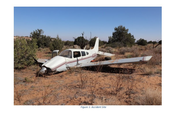
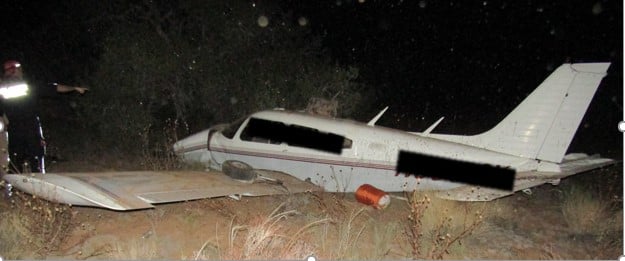
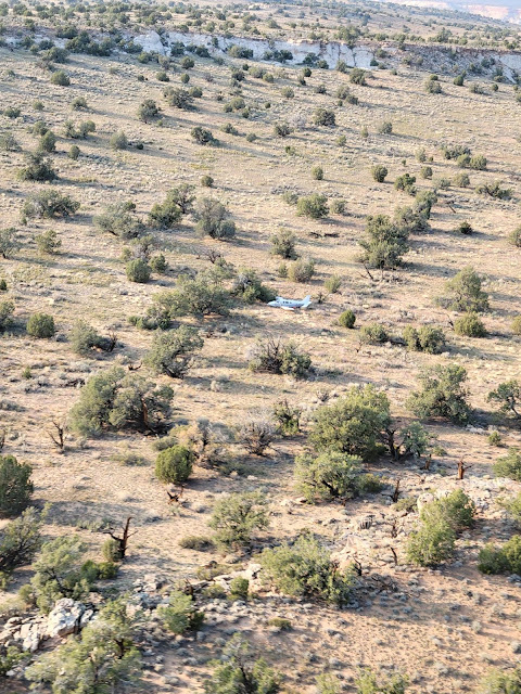
The airplane was located about 11 nm west of PGA on a mesa at a field elevation of about 6,150 ft msl. The airplane came to rest at a level attitude on a heading of 227° magnetic. The first point of impact (FPI) was identified by a 12-foot-tall Juniper tree and several broken tree branches. A debris path was marked by parallel ground scars that began about 20 ft forward of the FPI and was oriented on a heading of 155° magnetic. The outboard right stabilator was located on the left side of the debris path.
The main wreckage marked the end of the debris path and was located 62 ft beyond the FPI. The nose and main landing gear had collapsed and the fuselage was flush with the ground. Both wings remained attached to the fuselage; the left wing displayed a large compression wrinkle about midspan at the leading edge and the top skin. The inboard section of the right wing exhibited compression wrinkles about midspan. Both wings were punctured inboard above the right and left main landing gear. The ailerons and flaps were connected to their respective wings and were mostly undamaged, with exception of the right and left flaps, both of which exhibited upward bends at the inboard trailing edges. The left side of the stabilator had advanced forward several inches in a divergent path to the right stabilator, which had moved aft. Additionally, the right stabilator leading edge was crushed aft along the outboard leading edge about midspan. The vertical stabilizer and rudder were not damaged. The cowling and engine were displaced slightly downward, and the engine had separated from some of the upper mounts. Three propeller blades remained attached to the engine at the propeller hub. One blade was bent aft about midspan, one blade was bent at the blade root beneath the engine and the last blade was straight. Two of the propeller blades did not contain any visible chordwise scratches, nicks, or gouges. The third propeller blade was observed beneath the engine and could not be inspected. All major structures were accounted for at the accident site.
Aircraft and Owner/Operator Information
Aircraft Make: Piper
Registration: N3906X
Model/Series: PA-28R-200
Aircraft Category: Airplane
Amateur Built:
Operator: On file
Operating Certificate(s) Held: None
Operator Designator Code:
Meteorological Information and Flight Plan
Conditions at Accident Site: VMC
Condition of Light: Day
Observation Facility, Elevation: KPGA,4310 ft msl
Observation Time: 16:53 Local
Distance from Accident Site: 12 Nautical Miles
Temperature/Dew Point: 30°C /-4°C
Lowest Cloud Condition: Clear
Wind Speed/Gusts, Direction: 6 knots / , 20°
Lowest Ceiling: None
Visibility: 10 miles
Altimeter Setting: 30.13 inches Hg
Type of Flight Plan Filed: None
Departure Point: San Martin, CA (E16)
Destination: Page, AZ (PGA)
Wreckage and Impact Information
Crew Injuries: 1 Fatal
Aircraft Damage: Substantial
Passenger Injuries: 1 Serious
Aircraft Fire: None
Ground Injuries:
Aircraft Explosion: None
Total Injuries: 1 Fatal, 1 Serious
Latitude, Longitude: 36.905783,-111.68978
Those who may have information that might be relevant to the National Transportation Safety Board (NTSB) investigation may contact them by email witness@ntsb.gov, and any friends and family who want to contact investigators about the accident should email assistance@ntsb.gov. You can also call the NTSB Response Operations Center at 844-373-9922 or 202-314-6290.

Jim and Ute Petersen
~

Hudson
~
Hudson
~
SALT LAKE CITY — An incredible story of survival and heartache after a plane goes down in the desert, just outside of Page, Arizona.
The passenger, who managed to survive, was trapped for four hours, waiting for rescuers — all while sitting next to her husband, the pilot, who did not make it out alive.
“I was holding him for a long time. I pretended that he’s just unconscious, and I’m too stupid to feel a pulse,” Ute Petersen, 58, told KSL-TV from her home in Morgan Hill, California. “Deep down, I knew he was gone.”
On September 22, Ute and her husband, Jim Petersen, 57, left the Bay Area and were on their way to the Page Municipal Airport to meet up with some friends for a weeklong trip to Lake Powell.
About 10 minutes to the airport, their plane suddenly dropped from the sky.
Ute Petersen said there was no warning whatsoever.
“It was very, very quick. All of a sudden, Jim, I could tell he was getting upset,” she said. “He started to maneuver the airplane, hit a bunch of buttons on the dashboard, and then the next thing I know, we’re on the ground.”
After crash landing, Petersen became pinned in the co-pilot’s seat where she was sitting.
“I feel like I got run over by a freight train,” said Petersen, who’s still recovering from the crash. “I have a lot of injuries — I broke my nose, I have a really big seatbelt burn on my shoulder, I broke my sternum, I broke a couple of ribs, I broke my collarbone. I’m pretty much black and blue all over my body.”
While sitting there in the plane, Petersen didn’t know what to do. She said there was no way out and no way to call for help because there was no cell service.
Then, suddenly, her phone rang, and it was her friend who was picking her up from the airport, checking in on her.
She credits that call to divine intervention that saved her life.
“There is absolutely no reason that call should have gone through,” said Petersen.
Inside the plane was the couple’s two dogs — Hudson, the golden retriever, and little Kota.
Both dogs survived, but when rescuers arrived four hours later, Hudson bolted out the airplane door.
He was lost for three days in the desert, only to be miraculously found alive.
After three days, Hudson was miraculously found alive.
“I already have to wrap myself around losing my husband, and having the dogs back gives me strength and gives me a reason to pull through,” she said.
Ute and Jim had just celebrated their 30th wedding anniversary last month and were dreaming of retirement.
“I really loved him very much,” she said. “He was my best friend. He was my best friend, my partner, my lover, my husband.”
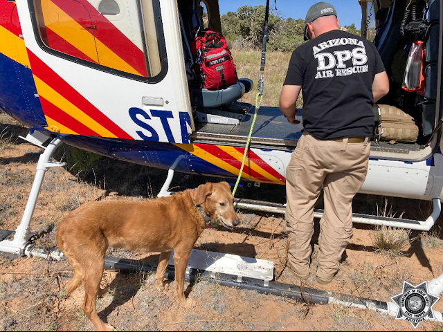
On Wednesday, September 22, 2021, the AZDPS Western Air Rescue crew responded to assist the Coconino County Sheriff’s Office with a small plane crash involving one fatality and one injured survivor in Paria Plateau near Page, Arizona.
As they arrived at the crash scene that night, our pilot and trooper-paramedics spotted a dog sitting near the plane wreckage. Unfortunately, the dog ran away as our helicopter landed at the scene and could not be located.
When our Central Air Rescue crew flew federal investigators back to the crash scene on Saturday, September 25, they spotted the missing dog lying next to the plane wreckage. The pup fled the area again when the helicopter landed, but crew members used water to lure him back and get a leash on him. He was tired, thirsty, and hungry, but this tough guy seemed to be in decent shape for having survived a plane crash and a few days in the Arizona wilderness.
Our air rescue crew flew the dog to the Page Airport, where he was met by a Coconino County Sheriff’s Deputy who would return him to his family.
AZDPS is grateful we could assist CCSO and help reunite this pup with the family at such a difficult time. Our thoughts and prayers are with the victims and their loved ones.
PAGE, Arizona - More information is coming out about how a woman was saved from a plane crash after dusk in northern Arizona in September.
A husband and wife were headed to Page and all of the beauty around it like Lake Powell when something happened.
The Federal Aviation Administration says the small plane crashed.
"The pilot was killed but the wife was able to send a text to a friend or family member saying they crashed."
Civil Air Patrol Vice Commander Lt. Colonel John Henderson is with the National Radar Analysis Team.
They're a group of volunteers who, at a moment's notice, can analyze data and create charts to pinpoint crash sites.
"Any time you have a crash and there are survivors, time is of the essence because they can quickly go downhill if too much time goes by. That's why we always try to get a resolution before it goes dark, for instance."
But it was already dark, meaning visually finding the crash site would be hard. And the clock was ticking.
Compiling the data, they were able to narrow it down to the Paria Plateau, just to the west of Page. It took the volunteer team of three just seven minutes.
"We tracked the aircraft down to 125 feet above the terrain so we knew right where it was and the rescue helicopter, even though it was after dark, was able to fly directly to the crash site."
A medical helicopter lifted the woman, identified as Uta Petersen, to a hospital and safety. Unfortunately, her husband and pilot, Jim Petersen, died.
Three days later, teams were back at the site investigating when they were able to lure a dog back to safety and reunite it with its family.
Henderson says without his team, and the wife's text for help, it could have taken hours instead of minutes.
The National Radar Analysis Team is relatively new - they just started in 2009. Already, they've been involved in 800 missions and are credited with saving 62 lives.

PAGE, Arizona — It was an improbable homecoming for a dog that survived a deadly plane crash in northern Arizona. The plane went down on September 22 in the Paria Plateau area, which is nearly 30 miles southwest of Page. The pilot, Jim Petersen, was killed and his passenger, Uta Petersen, was hurt. When first responders arrived at the crash scene, the Arizona Department of Public Safety said the paramedics spotted a dog sitting near the plane wreckage. But the pup ran off as soon as the pilot landed the helicopter and couldn't be found.
A few days later, when investigators went back to the scene, the same dog was lying next to the plane wreckage. The dog ran off again when the helicopter landed, but crew members used water to lure him back and get a leash on him, DPS said. The tired pup was hungry and thirsty. "This tough guy seemed to be in decent shape for having survived a plane crash and a few days in the Arizona wilderness," DPS said.
The crew flew the dog to the Page Airport. A Coconino County Sheriff's deputy took the dog and reunited him with his family. DPS said it's grateful it could help return this dog to the family during such a difficult time.


Hopefully the passenger will recover fully. Rest In Peace to the pilot. They flew a route I’ve flown many times, departing San Martin airport eastward bound. Prudent to fly south to the lower elevation Sierras.
ReplyDeleteMy deepest condolences.
ReplyDelete"PAGE, AZ (3TV/CBS 5/AP) -- A pilot has died and his lone passenger is hurt after a small plane crashed west of Page Wednesday night, according to the Federal Aviation Agency and the National Transportation Safety Board.
Coconino County Sheriff's officials say they received a call around 9:15 p.m. from the Page Airport that a plane originating from San Martin, California, had crashed while on approach. Authorities have identified the pilot as Jim Petersen and the passenger as Uta Petersen."
News link to a photo of the crashed aircraft. It went in wings level and appears to have been in a stall with the main gear shoved through the wing. No flaps deployed. RIP pilot and best wishes for a full recovery the apparent wife passenger.
ReplyDeletehttps://www.azfamily.com/news/pilot-killed-passenger-hurt-in-small-plane-crash-west-of-page/article_8d6819b0-1c86-11ec-9304-6b66a595a587.html?block_id=997196
"The Coconino County Sheriff’s Office said the crash was reported around 5:30 p.m. in the Paria Plateau area west of Page, AZ."
ReplyDelete@ Elev 4314 ft, 36.92 °N, 111.45 °W The Bear's Den B&B - KAZPAGE11 local weather "5:34 PM 84.0 °F 33.1 °F 16 % ENE 0.5 mph 0.9 mph 29.86 in 0.00 in 0.00 in"
Actual Time7:16 AM7:21 PM
Civil Twilight6:50 AM7:47 PM
Nautical Twilight6:20 AM8:17 PM
Astronomical Twilight5:50 AM8:47 PM
Crash location is near the east edge of the Paria Plateau as indicated by ADS-B data of Arizona Department of Public Safety Ranger Helicopter N58AZ (see links below) that flew to the crash site from Kingman AZ after dark to investigate the scene.
ReplyDeleteInitial locating was done by the Classic Air Medical helicopter dispatched from Page based on the last known location provided by Air Force Rescue Coordination Center. The surviving passenger called a friend after the crash, which reportedly led to Page Airport personnel initiating the search (see rescue story link below).
ADS-B Visualization, N58AZ arriving at Paria Plateau:
https://www.flightradar24.com/data/aircraft/n58az#293fc732
Pinned map location:
http://maps.google.com/maps?t=k&q=loc:36.9071+-111.6888
Flightaware N58AZ track and log:
https://flightaware.com/live/flight/N58AZ/history/20210923/0317Z
https://flightaware.com/live/flight/N58AZ/history/20210923/0317Z/tracklog
Rescue story:
https://www.lakepowelllife.com/fatal-plane-crash-in-paria-plateau/
Some Classic Air Medical tracks to/from Paria Plateau:
DeleteN407CH going to crash site from Page:
https://www.flightradar24.com/data/aircraft/n407ch#293fac6f
N407CH leaving crash site, going to St. George (part one):
https://www.flightradar24.com/data/aircraft/n407ch#293fc4a8
N407CH going to St. George from crash site (part two):
https://www.flightradar24.com/data/aircraft/n407ch#293fcf03
N407CH St. George return to Page w/orbit over crash site:
https://www.flightradar24.com/data/aircraft/n407ch#293feabb
N407CP going to crash site from Page:
https://www.flightradar24.com/data/aircraft/n407cp#293fb8d4
N407CP Returning to Page from crash site:
https://www.flightradar24.com/data/aircraft/n407cp#293feb14
Looks totally survivable... providing one had seatbelt/shoulder harness properly worn?
ReplyDeleteAs I understand it, he was carrying a small outboard boat motor and was struck in back of head at impact.
DeleteThat would make sense when I first read about this crash I was wondering if they had shoulder belts. Looks like to me it was a forced landing.
Delete
ReplyDeleteMenu
Home
About
What We Do
Links
News
Events
Passing of former SCAPA President Jim Petersen
Leave a Comment / News / By Mark van Wyk
It is with great sadness that I report the passing of former SCAPA President, and current SCAPA board member, Jim Petersen, who was killed in a crash of his airplane, a Piper PA-28R-200, tail number N3906X, on Wednesday, September, 22, 2021, near Page, AZ.
His passenger, wife Uta Petersen, survived with multiple injuries and is in the hospital.
I have little additional information at this time.
Everyone who knew Jim will tell you he was a unique, one-of-a-kind guy.
I am personally devastated at the news.
More information will be forthcoming.
Mark van Wyk
SCAPA Secretary and Treasurer
https://scpilots.org/passing-of-former-scapa-president-jim-petersen/
It was fortunate that the surviving passenger was within cell service range and able to make a phone call to a friend and report the crash.
ReplyDeleteLaunching of N407CH at 8:30PM to search on radar position coordinates provided by AFRCC in response to the notification chain that was reportedly underway at 5:30 PM suggests that the aircraft's ELT was not activated by the crash.
A lesson learned from this crash is that mounted ELT's can fail to operate even in crashes where the aircraft is relatively intact and the inertia switch should have activated. Purchasing and registering a Personal Locator Beacon (PLB) should be considered for flying in remote areas.
AFRCC detection of beacon-transmitted coordinates via NOAA SARSAT from a PLB activated by the conscious survivor in this accident would have allowed the rescue helicopter to launch that fifteen minute flight to the accident scene at least two hours sooner vs. AFRCC having to obtain a position from area radar history review.
Praise and gratitude goes out to everyone involved in overcoming the locating challenge and performing the rescue. Hope the survivor makes a full recovery.
view the circuitous flight track log, appears to have been a challenging flight of 3h 42m...
ReplyDeleteWednesday 22-Sep-2021
Depart: 12:12 PDT San Martin - E16
Last seen at 15:54 MST near Colorado City, AZ
https://flightaware.com/live/flight/N3906X/history/20210922/1941Z/E16/L%2036.72341%20-113.09459/tracklog
The POA forum had comments on smoke from fires as a likely cause of the circuitous route and that there would be less fuel reserve compared to a more direct route plan.
DeleteThe 3h 42m to where ADS-B recording was not in range of a receiver after Colorado City is about 64 nautical miles short of Paria Plateau, so there is another 30 minutes added, for a time aloft of four hours, twelve minutes.
Full fuel is 50 gallons, 48 useable. If the burn rate averaged 10 GPH including climb, 48 gallons would be 4h 48 minutes.
From Flightaware, Peterson began a controlled descent from 11,500 ft to 7,400 ft at 3h 8m. This is about 2,500 ft AGL. He continued eastward at this altitude for 14m until the flight abruptly ended. There is no way he could have descended 2,500 ft without multiple ADS-B fixes, so what caused the interruption? One possibility could be a total electrical failure. The plane impacted the ground in a controlled way with landing gear extended. Notably, there was no evidence of fire. This means that there was no fuel onboard or no source of ignition. As Peterson flew close by St. George it is unlikely he was low on fuel.
ReplyDeleteLack of reception of ADS-B signal in Arizona does not indicate abrupt end of a flight or electrical failure.
DeleteLook at the gap in received ADS-B data for the State of Arizona's helicopter N58AZ when it flew through the same area to reach the crash location or gaps in the air medical flight to St. George, as linked below:
N58AZ flight to Paria Plateau:
https://www.flightradar24.com/data/aircraft/n58az#293fc732
Air medical flights (zoom out tracks for context):
N407CH leaving crash site, going to St. George (part one):
https://www.flightradar24.com/data/aircraft/n407ch#293fc4a8
N407CH going to St. George from crash site (part two):
https://www.flightradar24.com/data/aircraft/n407ch#293fcf03
N407CH flew from Page, AZ, to St. George, UT, medical center, where it lost ADS-B contact on the ground (it had complete coverage while airborne and was closer to N3906X's flight path). N58AZ flew from Page to the Kingman, AZ, medical center, some distance from the accident plane's path. I said an electrical failure was a possibility, which it is, especially when considered in the context of the lack of a post-crash fire where the wing fuel tanks were clearly breached. Another possibility is that Petersen deliberately shut off electrical power in anticipation of a crash landing. But if the electrical didn't fail why wouldn't he transmit a mayday first with so much altitude remaining?
DeleteIf my reasoning is correct, actually tracked about about 44 miles south @ 36.6751 -113.5046, St Georges @ 37.0363781,-113.5103028.
Delete(.69 * 64 = 44)
Measurements at 40 degrees North Latitude (N or S). A Change in Latitude of .01 degree = .69 miles
There is a hole in ADS-B coverage in the area N3906X went down, and N407CH did lose coverage in the same area:
ReplyDeletehttps://flightaware.com/adsb/coverage/#data-coverage
We will have to wait for further details, especially what the surviving passenger has to say, to determine the cause.
The potential for fuel exhaustion is something to think about while waiting to hear what the surviving passenger has to say.
DeleteSometimes small changes can produce magnified effects when combined with other variables. The reduction in fuel margin from the lengthened fight path could have led to squinting at tank level gauges and hoping the indications were accurate.
Tank level gauges have deceived many a pilot that just this one time decided to use them to avoid an unplanned fuel stop close to the destination in spite of years of disciplined piloting without relying on them. That may not have happened in this accident, but don't let it happen to you.
Yes, fuel exhaustion is a definite possibility considering the controlled nature of the crash and no post-crash fire, but they should have had 30 min of fuel remaining at the point of the crash.
Deletehttps://www.azfamily.com/news/pets_animals/dog-survives-plane-crash-page/article_c6e8ba04-2240-11ec-b7d8-2fb626c18215.html
ReplyDeleteDog reunited with family after surviving deadly plane crash near Page
DAVID BAKERPOSTED SEP 30, 2021
The dog was hungry and thirsty.
PAGE, AZ (3TV/CBS 5) — It was an improbable homecoming for a dog that survived a deadly plane crash in northern Arizona. The plane went down on Sept. 22 in the Paria Plateau area, which is nearly 30 miles southwest of Page. The pilot, Jim Petersen, was killed and his passenger, Uta Petersen, was hurt. When first responders arrived at the crash scene, the Arizona Department of Public Safety said the paramedics spotted a dog sitting near the plane wreckage. But the pup ran off as soon as the pilot landed the helicopter and couldn't be found.
Pilot killed, passenger hurt in small plane crash west of Page
A few days later, when investigators went back to the scene, the same dog was lying next to the plane wreckage. The dog ran off again when the helicopter landed, but crew members used water to lure him back and get a leash on him, DPS said. The tired pup was hungry and thirsty. "This tough guy seemed to be in decent shape for having survived a plane crash and a few days in the Arizona wilderness," DPS said.
The crew flew the dog to the Page Airport. A Coconino County Sheriff's deputy took the dog and reunited him with his family. DPS said it's grateful it could help return this dog to the family during such a difficult time.
Copyright 2021 KPHO/KTVK (KPHO Broadcasting Corporation). All rights reserved.
https://ksltv.com/473892/plane-crash-survivor-describes-miracle-that-led-to-her-rescue/
ReplyDeletePreliminary report stating "Two of the propeller blades did not contain any visible chordwise scratches, nicks, or gouges." tells you the fan stopped.
ReplyDeleteSurvivor says the crash happened quickly: “It was very, very quick. All of a sudden, Jim, I could tell he was getting upset,” she said. “He started to maneuver the airplane, hit a bunch of buttons on the dashboard, and then the next thing I know, we’re on the ground.”
The low altitude crossing Paria Plateau is puzzling, as it didn't provide much engine out glide distance. Could have reached Paria-adjacent Marble Canyon Airport at it's lower elevation of 3603' MSL if altitude was higher crossing Paria Plateau.