

David Hodges
This is preliminary information, subject to change, and may contain errors. Any errors in this report will be corrected when the final report has been completed.


The pilot who perished in a plane crash Wednesday west of Discovery Bay has been identified as David William Hodges, 66, of Friday Harbor.
Investigator In Charge (IIC): Cawthra, Joshua
The National Transportation Safety Board traveled to the scene of this accident.
Additional Participating Entities:
Federal Aviation Administration / Flight Standards District Office; Seattle, Washington
Justin Hanson; Federal Aviation Administration; Des Moines, Iowa
Cirrus Aircraft; Duluth, Minnesota
Location: Blyn, Washington
Accident Number: WPR22FA298
Date and Time: August 10, 2022, 14:59 Local
Registration: N379DH
Aircraft: CIRRUS DESIGN CORP SR22
Injuries: 1 Fatal
Flight Conducted Under: Part 91: General aviation - Personal
On August 10, 2022, about 1459 Pacific daylight time, a Cirrus SR22, N379DH, was substantially damaged when it was involved in an accident near Blyn, Washington. The pilot was fatally injured. The airplane was operated as a Title 14 Code of Federal Regulations Part 91 personal flight.
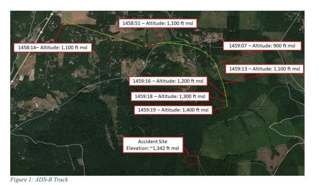
Recorded Automatic Dependent Surveillance Broadcast (ADS-B) data showed the airplane departed Friday Harbor Airport, Friday Harbor, Washington, about 1445, and proceeded on a southerly heading as it ascended to an altitude of about 1,100 ft mean sea level (msl). The airplane continued south until about 1458:14, when a loss of ADS-B coverage occurred. At 1458:51, ADS-B contact was reestablished,
and the data showed the airplane on an easterly heading. About 1 second later, a right turn to a southerly heading along with a descent to 900 ft msl. At 1459:07, a second loss of ADS-B coverage occurred, and was reestablished about 6 seconds later. The data showed the airplane on a southerly heading, at an altitude of 1,100 ft msl. The last ADS-B target was at 1459:19, at an altitude of 1,400 ft msl, located about 0.63 miles northeast of the accident site.
Examination of the accident site revealed that the airplane impacted a heavily wooded area. The first identified point of contact was a freshly topped tree, with composite material fragments located near the tree root. The debris path initially extended along an approximate 270° heading, for about 300 ft, before shifting to an approximate 312° heading, which extended for about 155 ft. The fuselage came to rest inverted on a heading of about 301°. All major structural components of the airplane were located within the debris path. The wreckage was recovered to a secure location for further examination.

Aircraft and Owner/Operator Information
Aircraft Make: CIRRUS DESIGN CORP
Registration: N379DH
Model/Series: SR22
Aircraft Category: Airplane
Amateur Built:
Operator: On file
Operating Certificate(s) Held: None
Operator Designator Code:
Meteorological Information and Flight Plan
Conditions at Accident Site: VMC
Condition of Light: Day
Observation Facility, Elevation: KCLM, 273 ft msl
Observation Time: 14:53 Local
Distance from Accident Site: 23 Nautical Miles
Temperature/Dew Point: 19°C /14°C
Lowest Cloud Condition:
Wind Speed/Gusts, Direction: 8 knots / , 260°
Lowest Ceiling: Overcast / 1300 ft AGL
Visibility: 10 miles
Altimeter Setting: 30.06 inches Hg
Type of Flight Plan Filed: None
Departure Point: Friday Harbor, WA (FHR)
Destination: Olympia, WA (OLM)
Wreckage and Impact Information
Crew Injuries: 1 Fatal
Aircraft Damage: Substantial
Passenger Injuries:
Aircraft Fire: None
Ground Injuries:
Aircraft Explosion: None
Total Injuries: 1 Fatal
Latitude, Longitude: 48.025685,-122.94394
Aircraft crashed under unknown circumstances.
Date: 10-AUG-22
Time: 22:10:00Z
Regis#: N379DH
Aircraft Make: CIRRUS
Aircraft Model: SR22
Event Type: ACCIDENT
Highest Injury: FATAL
Total Fatal: 1
Flight Crew: 1 Fatal
Pax: 0
Aircraft Missing: No
Damage: UNKNOWN
Activity: PERSONAL
Flight Phase: UNKNOWN (UNK)
Operation: 91
City: BLYN
State: WASHINGTON
Those who may have information that might be relevant to the National Transportation Safety Board (NTSB) investigation may contact them by email witness@ntsb.gov, and any friends and family who want to contact investigators about the accident should email assistance@ntsb.gov. You can also call the NTSB Response Operations Center at 844-373-9922 or 202-314-6290.

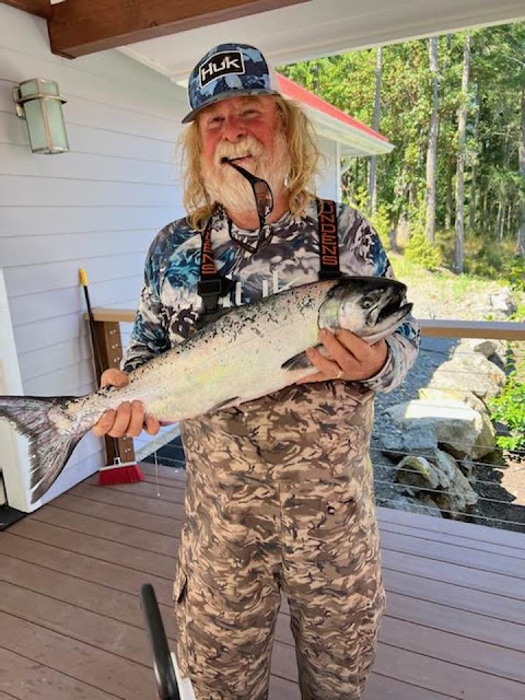
David Hodges
1956 - 2022

In loving memory of David William Hodges, who passed unexpectedly on August 10th, 2022. In the name of the many who loved him, we mourn his loss and cherish his memory. Survived by his wife Nancy Marlett-Hodges, mother Mildred Hodges, his five children, and four grandchildren. Beloved by the community he built in both Santa Rosa and Friday Harbor, David was a songwriter, performer, businessman, hunting and fishing enthusiast, but above all an amazing family man. If he touched your life in the way he did ours, take a moment to remember the joy and generosity David was known for. Whether it be a joke, a gift from the sea, a shared adventure or story, please keep him in your thoughts and in your hearts. A memorial will be held at 1pm on October 1st, 2022 at the Santa Rosa Christian Church, located at 1315 Pacific Ave, Santa Rosa, CA 95404.


"At this point there is no confirmed cause for the crash," Detective Brett Anglin of the Jefferson County Sheriff's Office said Thursday in an email to The Leader.
The aircraft went down on Washington State Department of Natural Resources land
in the area between Diamond Point Road and the Maynard Peak radio site.
Hodges was believed to have been flying from Friday Harbor to Olympia.
"It is suspected at this point in time that fog may have been the cause, or contributed to the crash," Anglin added. "There was a significant fog bank in the area at the time, limiting visibility for our rescue crews."
Officials from the National Transportation Safety Board and the Federal Aviation Administration were at the crash site Thursday conducting an investigation.
The aircraft was identified as a Cirrus SR22, a single-engine four- or five-seat composite aircraft built by Cirrus Aircraft of Duluth, Minnesota.
"These incidents are always tragic event for the family involved, the first responders, and the neighbors who witnessed the event," Anglin added. "The quick actions by the community to report their observations proved vital in narrowing down the location of this scene."
Authorities earlier said a witness near the suspected crash site gave an excellent description of where they thought the plane had gone down, with the presumed crash location about a mile away in thick-forested land.
The Clallam County Fire District and Clallam County Sheriff’s Office initially responded to the report in the Blyn/Gardiner area.
The response included a fire engine and aid car from the Diamond Point station, an engine with medic from the Blyn station, and a rescue truck and medic unit from the Sequim station.
The Clallam County Sheriff’s Office search-and-rescue team, as well as a search-and-rescue helicopter from Naval Air Station Whidbey Island, were also requested.
Deputies from the Jefferson County Sheriff's Office arrived on scene quickly and added two unmanned aerial vehicles, better known as drones, to the search. Meanwhile, both the Clallam and Jefferson County search-and-rescue teams staged and prepared to look for the downed aircraft.
It was determined the crash site was likely in Jefferson County, so a unified command was established with Jefferson County Sheriff's Office and the fire district.
Shortly thereafter the search-and-rescue helicopter arrived and took over the aerial search.
Fog in the area hampered the view, but when a break in weather occurred, the helicopter was able to locate the crash site between Diamond Point Road and the Maynard Peak radio site and lower crews down.
A single victim was found, and the body was recovered and flown from the site.
Crews then entered the crash site on foot to conduct a search to confirm that there were no additional victims.
"As the responding duty chief, I was very impressed with the level of assistance, co-operation, coordination and expertise shown by all of the responders,” Andrews said.
”Several community members with local knowledge were also a great help in locating and accessing the crash site as quickly as we did. The effectiveness of this operation was due to everyone truly working together towards a common objective,” he added.


One of the valuable components of this website is that the people involved with general aviation accidents have names, faces, families and histories. Otherwise they would be just "statistics". The comment section varies between the obtuse and the enlightened depending on the commenter. I learn a lot from KR about what it takes to keep an airplane safely in the air and have gained respect for the people who do so with their expertise and humility.
ReplyDeleteThe photos are relevant, because the unfortunate circumstances reported are not just about machines. These things happen to real people. People just like us who probably thought it couldn't happen to them.
ReplyDeleteHead scratcher since pulling the chute if in trouble above 500 ft is now strongly encouraged. Especially for an engine out.
ReplyDeleteHaving gone through all the training after getting a new Cirrus myself I can attest how safety is #1 and this is a very safe and well built airplane with triple redundancy for the electrical system and tons of safety features besides the chute, which the rest of GA seems fixated on like some kind of fetish. Well the blue button on the AP for level flight would probably be more important as well as the electronic checklists and emphasis on procedure and basically flying the aircraft as a transport category plane. Any CPL/ATP will be right at home in such an aircraft and fly it with better avionics than an Airbus or Boeing given the G1000 nXi.
My hunch is with increase in insurance rates some pilots will fly without any since it is not federally required on small planes. Hence why they will try to salvage the aircraft and here maybe do that instead of pulling the chute which technically will damage the fiberglass airframe beyond salvation (hidden cracks etc... due to ground impact etc...). Then again most Cirrus are only affordable to people with decent means so a lack of insurance wouldn't explain this. Unless it's an older model like here i.e 2005.
Instead of pulling the chute, which technically will damage the fiberglass airframe beyond salvation (hidden cracks etc... due to ground impact, etc...).
DeleteThis comment is wrong. A large amount of "chute pull" aircraft are again flying.
The plane did not have the "blue level button" on the AP. It had a STEC55X AP.
DeletePulling the chute should be second nature though for any engine issue. Set the best glide and target FLC to 500-600 ft and try to restart and if the 500 ft AGL is reached pull it.
DeleteIf you draw a straight line between Friday Harbor airport and Olympia airport you will end up at the crash site in an area of rising terrain. Maynard Hill 2106 feet high. If you continue south towards Olympia the terrain rises to 4400 feet. On Flight Aware, the last hit was at 1000 feet heading 068 degrees. 19 seconds later he headed 126 degrees which puts you directly into the side of Maynard hill. It is possible that looking at the track that he may have thought that he was over the Port Townsend area when he actually had headed up Sequim Bay, realized his mistake and turned east. I don't think the Cirrus parachute was ever an option in this case when you fly into a hill at 160 mph. I have lived in this area most of my
ReplyDeletelife and this was one many aircraft who have flown into Maynard Hill. With todays moving map technology and tools like Foreflight this accident is kind of hard to figure out. I'll leave that to the NTSB.
After looking at FlightAware, the flight is not meandering like one would expect with unexpected IMC. As for using the parachute, we don’t know the situation. I have a cirrus and it would definitely take me a few seconds to remember to pull the handle. Nonetheless, he was in his sixties and it is possible there were health issues. Only time will tell.
ReplyDeleteScud running steady at 1000' and about 130 mph GS- https://flightaware.com/live/flight/N379DH
ReplyDeleteStarted a level escape to the East just a bit too late.
Preliminary report came out but doesn't include any info on whether trees have cut marks, or whether the prop has S-bends, or anything at all about as-found engine condition.
ReplyDeleteCrash location coordinates don't say "estimated" for a change, making it possible to pin it on google maps and then switch layers to terrain view and look at rising terrain there.
http://maps.google.com/maps?t=k&q=loc:48.025685+-122.94394
IMC shouldn't have been a problem if he was current and proficient on his skills, as he was Instrument rated.
ReplyDeleteDAVID WILLIAM HODGES
45 BOSUNS REACH
THE SEA RANCH CA 95497
County: SONOMA
Country: USA
Medical Information:
Medical Class: Third Medical Date: 8/2019
BasicMed Course Date: 8/3/2021 BasicMed CMEC Date: 7/30/2021
Certificates
PRIVATE PILOT
Certificates Description
Certificate: PRIVATE PILOT
Date of Issue: 6/15/2005
Ratings:
PRIVATE PILOT
AIRPLANE SINGLE ENGINE LAND
INSTRUMENT AIRPLANE
Hope they do a proper autopsy, this sounds like it could easily be a health issue. Otherwise, for the life of me how rated pilots can still run into hillsides with a G1000 and all the wiz bangs is beyond me. The Cirrus is somewhat of the modern day split tail Bonanza. Too much money and too little sense.
ReplyDelete