
The National Transportation Safety Board traveled to the scene of this accident.
Additional Participating Entities:
Federal Aviation Administration / Flight Standards District Office; Sacramento, California
Textron; Wichita, Kansas
Trinity Flyers

Location: Dunsmuir, California
Accident Number: WPR22FA021
Date and Time: October 20, 2021, 11:00 Local
Registration: N5268Q
Aircraft: Cessna 150L
Injuries: 1 Fatal
Flight Conducted Under: Part 91: General aviation - Personal
On October 20, 2021, about 1100 Pacific daylight time, a Cessna 150L, N5268Q, was substantially damaged when it was involved in an accident near Dunsmuir, California. The pilot was fatally injured. The airplane was operated as a Title 14 Code of Federal Regulations Part 91 personal flight.
Family member stated that the pilot departed from Rake's Glen Airport (WA59), Sequim, Washington about 1000 on October 19, 2021, and was destined for Haigh Field Airport (O37), Orland, California.
The Federal Aviation Administration (FAA) issued an alert notification (ALNOT) on October 20, at 1925, after a family friend was unable to reach the pilot on his cell phone and reported the missing aircraft. A search ensued and the airplane wreckage was discovered the following day about 1200, on a rising face of Mt. Bradley about 725 ft below the summit, and 2 nm northwest of Dunsmuir, California.
A power company employee who was working near the Mt. Bradley lookout point on the day of the accident, reported 200 ft visibility and a fog layer that extended to the top of the mountain for most of the morning and through the early afternoon. He heard a low-level airplane flying about 1130 at which time he noted that the engine sounded as if it was running. The witness did not hear the airplane impact terrain.
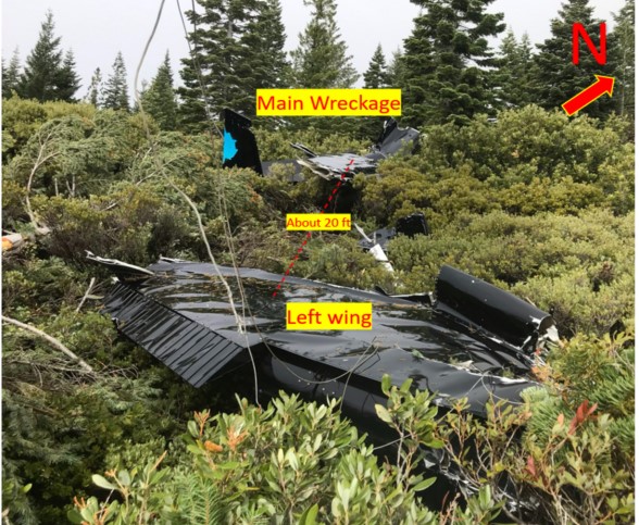
The wreckage was located on a mountain side at a field elevation of about 5,290 ft mean sea level (msl). The airplane came to rest on a slope (figure 1) and was oriented on a heading of 350° magnetic. The first point of impact (FPI) was identified by the severed tops of two 40-foot-tall pine trees and several broken tree branches. A debris path was marked by tree strikes that began about 75 ft forward of the FPI and oriented on a heading of 360° magnetic. The main wreckage marked the end of the debris path and was located about 225 ft beyond the FPI. All major structures necessary for flight were accounted for at the accident site.
Aircraft and Owner/Operator Information
Aircraft Make: Cessna
Registration: N5268Q
Model/Series: 150L
Aircraft Category: Airplane
Amateur Built:
Operator:
Operating Certificate(s) Held: None
Operator Designator Code:
Meteorological Information and Flight Plan
Conditions at Accident Site:
Condition of Light:
Observation Facility, Elevation: KMHS,3535 ft msl
Observation Time: 10:58 Local
Distance from Accident Site: 7 Nautical Miles
Temperature/Dew Point: 10°C /8°C
Lowest Cloud Condition: Scattered / 500 ft AGL
Wind Speed/Gusts, Direction: 4 knots / , 130°
Lowest Ceiling: Broken / 1800 ft AGL
Visibility: 8 miles
Altimeter Setting: 30.08 inches Hg
Type of Flight Plan Filed:
Departure Point:
Destination:
Wreckage and Impact Information
Crew Injuries: 1 Fatal
Aircraft Damage: Substantial
Passenger Injuries:
Aircraft Fire: None
Ground Injuries:
Aircraft Explosion: None
Total Injuries: 1 Fatal
Latitude, Longitude: 41.2197,-122.30906
Those who may have information that might be relevant to the National Transportation Safety Board (NTSB) investigation may contact them by email witness@ntsb.gov, and any friends and family who want to contact investigators about the accident should email assistance@ntsb.gov. You can also call the NTSB Response Operations Center at 844-373-9922 or 202-314-6290.
Shasta County Sheriff's Office
The Shasta County Sheriff's Office and members of our Search and Rescue Team assisted the Siskiyou County Sheriff’s Office today in the effort to locate a missing aircraft. As confirmed by Siskiyou County officials, the wreckage was located near Bradley Peak in southern Siskiyou County. Our thoughts are with the loved ones of the solo pilot of the aircraft who did not survive. We would like to express our gratitude to the Search and Rescue volunteers who worked tirelessly in the effort and:
CHP - Northern Division Air Operations;
Shasta County Search and Rescue Jeep Patrol;
Shasta County Search and Rescue Ground Team;
Shasta County K9 Search and Rescue;
Shasta County Sheriff Mounted Search and Rescue;
Siskiyou County Sheriff Search and Rescue.
Siskiyou County Sheriff’s Office
The Siskiyou County Sheriff’s Office regretfully reports the positive identification of the decease person at the plane crash site on Bradley Peak. Mr. William Bushling was positively identified by our investigators. His family has been notified. Our thoughts and prayers are with his family.
CHP - Northern Division Air Operations
Not the outcome we wanted. H-14 and A-11 assisted Siskiyou County Sheriff’s Office and Shasta County Sheriff's Office in locating a Cessna 150L, which was reported missing on Wednesday. A citizen reported the wreckage on the south side of Mt. Bradley, near the outlook. Unfortunately the pilot was found deceased. H-14 assisted ground crews due to the steep terrain. Thoughts and prayers to the pilots family.
William Bushling
~
Siskiyou County, California — UPDATE: According to a Facebook post by the Siskiyou County Sheriff’s Office, their investigators have positively identified the plane crash victim as Mr. William Bushling. His family has been notified.
A plane that vanished in Northern California on Wednesday may have been found.
According to a Facebook post by the Siskiyou County Sheriff’s Office, a man believes he found the Cessna 150L that was reported missing when it failed to arrive at its intended destination of Orland, California.
Police say the aircraft took off heading south from Ashland around 9:00 am on Wednesday morning. The Trinity County Sheriff’s Office reportedly received a request for emergency landing from the pilot, 71-year-old William Bushling, but the plane never arrived. According to officials, the pilot’s cell phone last pinged a tower in the area of Highway 89 and Interstate 5 just northeast of Dunsmuir around 8:00 pm Wednesday night.
According to the Facebook post, Search and Rescue officials are currently searching the area where the plane was located.


Plane found in the area of Bradley Peak, Siskiyou County CA. The Pilot was fatally injured.
ReplyDeletehttps://fox40.com/news/local-news/small-plane-goes-missing-on-flight-from-oregon-to-airport-near-chico/
Do you have any more info? I am looking to find out who owns the land where the plane crashed.
ReplyDeleteThe way I recall the story was the pilot actually landed in Orland and was on his way back, this happened at night.
ReplyDelete