SARASOTA — Two Sarasota men have jumped into the world of commercial drones, knowing that federal regulations still stand between them and many job opportunities. But Chad Cox and C.J. Carlock, the co-founders of 4C Drone Solutions LLC, aren’t your typical hobbyists with dreams of making a living with the radio-controlled helicopters. They both have a lot of flight experience as professional pilots of luxury private jets carrying celebrities, professional athletes and wealthy business people around the world. Cox and Carlock fly out of Sarasota for NetJets, a Columbus, Ohio-based company owned by famed investor Warren Buffet that offers factional ownership of the aircraft. Cox was introduced to drones after he gave one for Christmas to his son, Riley, 19, in 2015 and watched him fly the unmanned aircraft outside their home in Lakewood Ranch. He began to research the possibility of a drone business with longtime friend Carlock. They discussed becoming partners in a business using drones to do surveying, 3D imaging and inspections of agricultural fields and other properties and structures. The possibilities include far more than pretty aerial video and still photography for real estate brochures and websites. Cox, a former flight instructor and American Eagle airline pilot, said it took him about 15 hours to become proficient flying drones. Carlock said he was more meticulous and it took him 10 times longer. They were both helped by Riley Cox, who they said had become an expert.
4C Drone Solutions LLC co-owner Chad Cox.
4C Drone Solutions was licensed in September 2016, Cox said. Although commercial drone pilots do not have to have licenses to fly actual aircraft — something considered in early proposed regulations — the experience helps their work with drones, the men say. The way safety is ingrained in their work, their intimate knowledge of weather and their experience navigating restricted airspace are all benefits of their pilot experience, Carlock said. The company uses a fleet of drones made by the Chinese company DJI: a Spark, Phantom 3, Phantom 4, Phantom 4 Pro, and an Inspire 2. They range in cost from $400 to $8,000, depending on optional features. They can be equipped with a 5.2K cinema-quality video-recording devices down to smaller, TV-quality 1080p cameras. Their high-resolution cameras that sense standard and near-infrared light provide precise data that can be exported and manipulated by a variety of mapping and analytical software, Carlock said. Cox said the men still find plenty of skeptics. The question they are asked most often is, “What’s a drone going to do for me?” Carlock said. “A lot of guys are old school — get on the ladder, look at the roof, walk on the roof. We want to show them you don’t necessarily have to do that anymore,” Cox said. “I can fly over a house, scan it, and it’ll tell me what the useful life is remaining on the roof. It’ll give me exact dimensions on the size of the roof, and if someone wants a quote on how much it’s going to cost me to get the roof fixed or roof replaced, the roofing contractor has more accurate data to base that off of.”
After Irma caused widespread damage to vegetation throughout Sarasota-Manatee, a large stockpile of yard debris was dumped near Lakewood Ranch High School in Manatee County. 4C Drone Solutions used the pile of rubbish to prove its worth, providing the county a free estimate of the amount of material. Cox talked to a Manatee County official about the idea of flying a drone over the debris pile. The man appeared hesitant. “He said, ‘What are you going to find out?‘” Cox recalled. “I went and flew over it and it took an hour to process the map. I went to him and said ‘You’ve got 2,212 cubic yards of material there.’ He just looked at me like ‘How do you know that?’” The county usually takes days to determine how much debris is in a pile like that by counting truckloads, Cox said. The county employee told Cox those efforts “can’t even get close” to being accurate. The drone startup has been called on primarily for mapping and agricultural assessments. They can fly over fields and determine whether fungus, pests or improper amounts of water are damaging crops. “The mapping and land developing jobs are a little bit of a reliable niche for us to be in right now,” Carlock said. “I think the word is slowly getting out there about us. It’s been a challenge.” Drone mapping jobs pay $250 to $400, depending on the size of the job, Cox said. 4C Drone Solutions also has been involved in a short suspense film and a country music video for a rising Nashville singer, Cox said. They are Zillow-certified photographers, so a Realtor using their business receives increased visibility in search results over a Realtor who took video themselves. Other common jobs performed by drones are exploration, search and rescue, and disaster recovery. They also can carry equipment to paint structures that otherwise would be difficult to reach and can carry Wi-Fi signals into areas that otherwise would not have a wireless data connection. Although Cox and Carlock began their drone business in the early days of the industry, they are not alone. There five or so other drone companies in the Sarasota area. And some FAA regulations and the length of time it takes to get permission to do some kinds of flights are an obstacle, too. The larger Phantom 4 and Inspire drones can reach the 400-foot drone flight ceiling and fly in 25 mph winds. Their maximum flight time is about 28 minutes, according to DJI’s website. Amazon and Google are both investigating the possibility of using drones to deliver packages. Cox and Carlock said even though their knowledge of airspace restrictions helps, it’s still and time consuming, even with the help of an intermediary, to receive exemptions from the FAA to fly in otherwise prohibited airspace. The process of applying for exemptions, which can take 90 days, has cost 4C Drone Solutions jobs. Each job requires a separate exemption. “They are erring on the side of caution at this point,” Carlock said of the FAA. But the men aren’t in a hurry. Cox and Carlock work about 20 days a month flying for Netjets. They said they will take time to grow 4C Drone Solutions, which is a part-time endeavor for now. The two friends are continuously finding applications for mapping software that can create digital surface and terrain models. “Looking back, we’re positioned where we want to be,” Carlock said. “We did a lot of learning and got ahead of everyone else who right now might be looking at it. We’ve done a lot of research. ... We can turn this into a good idea for someone who has a farm or baseball stadium.” “A lot of economists have said that it’s going to be, well, well into multimillion dollars,” Cox said of the growing industry. A look at basic drone rules A drone pilot must have Part 107 drone certification to fly commercially, and a Section 333 Exemption to fly in the Federal Aviation Administration-governed National Airspace System or within five miles of an airport, stadium, sporting event, hospital or areas affected by natural disasters. Drone pilots must take an exam and perform a flight review every two years. They do not need to pass a medical exam. They must be at least 16 years old. It costs about $150 for the initial test to obtain a commercial drone pilot’s license. The unmanned aerial vehicles, commonly called drones, must be registered with the FAA. They must weigh less than 55 pounds and they must remain within their operators’ sight. UAVs must be operated during daylight hours — defined as 30 minutes before sunrise and 30 minutes after official sunset. The complete list of regulations for Part 107 commercial drones is at FAA.gov. Story and photo gallery ➤ http://www.heraldtribune.com
A California-based jet-powered drone manufacturer is moving at least 350 employees and part of its engineering, design and manufacturing operations to Oklahoma City, company and state leaders said Friday. Kratos Defense & Security Solutions Inc. develops and manufactures jet drones used for military missile tests and other applications. The new Oklahoma City facility will be home to much of the company's design and manufacturing of a new version of offensive jet drones intended to be used in combat along with manned aircraft. "We can fly our aircraft as a wingman for an F-22," Steve Fendley, president of Kratos' unmanned systems division said in a news conference on Friday. "The manned pilot can fly to a proximity and deploy the unmanned aircraft farther without having to threaten himself." Kratos has four engineers and 25 support employees at a temporary Oklahoma City location. The company is looking for a permanent facility near Tinker Air Force Base where it will house its expanded research and production offices. The new location also will be home to some of the company's manufacturing operations. Fendley said he expects the company to be in the new facility by the end of the year and to have 350 to 500 Oklahoma City employees within five years.
Gov. Mary Fallin leads a press conference at the state Capitol on January 26, 2018.
"We're close to reaching our production capacity in California," Fendley said. "Our intention here is to install our tactical performance capability, both the development and production of those systems. For those tactical aircraft systems, their home will be here. We will develop and produce them here in Oklahoma." Aviation and aerospace is Oklahoma's second largest industry behind the energy sector, but Kratos represents a portion of the industry new to the state. "These are cutting-edge components of technology and aviation coming to Oklahoma City," said Roy Williams, president of the Greater Oklahoma City Chamber. "It represents the future of the industry. Much of what we have in Oklahoma City is maintenance and overhaul, which is taking care of everything that is old. This is the next wave of growth in the sector. We think this is a home run." Kratos also represents the revival of aerospace manufacturing in the state, said Vince Howie, aerospace and defense director at the Oklahoma Department of Commerce. "This is the beginning of a long and fruitful relationship," he said. "We've brought aircraft manufacturing back to Oklahoma." Kratos executives chose Oklahoma City after meeting with Rep. Steve Russell, R-Oklahoma City, Gov. Mary Fallin and other state and local leaders, Fendley said. "All of the pieces in Oklahoma fit what we were looking for," he said. "We wanted a state that is supportive of the business we're in, supportive of the military, supportive of advancements of our capability testing, have a close proximity to military bases and have the potential for a flight test facility." Fendley said his company is negotiating with the Federal Aviation Administration for the ability to run flight tests at the Oklahoma Air & Space Port in Burns Flat, which is home to the third-longest civilian airport runway in North America. "We hope to eventually do ground testing and possibly eventually flight testing there," Fendley said. "If we can do that, Oklahoma is really our center focus for all the development work we do." Kratos has conducted most of its tests on military bases in California, where it must work around military schedules. "The opportunity to take advantage of a facility like (Burns Flat) with the proximity we have with the size and capacity and ceiling all the way to space, is incredible," Fendley said. Besides the proximity to Burns Flat and Tinker Air Force Base, Fendley said the company also was drawn by the state's engineering and Quality Jobs tax credits. Oklahoma has a checkered history of providing tax credits to aerospace companies based at or interested in Burns Flat. Rocketplane, for example, took in $18 million in state subsidies before filing for bankruptcy in 2010. Gov. Fallin pointed out, however, that Krotos is an established company that operates in 20 states and five countries and has more than 3,000 employees and close to $1 billion in contracts. "This is not a startup company," she said. Earlier this month, Kratos announced a $23 million unmanned aerial drone system production award from an unnamed customer, and a $93 million contract to supply target drones to the Army. This most recent contract makes Kratos the sole supplier of jet-powered, sub-scale target drones to all branches of the U.S. military. Aerospace firms produced about $4.9 billion in goods and services in the Oklahoma City metro, according to a 2016 study by the Greater Oklahoma City Chamber. Tinker Air Force Base is a major driver for the local aerospace industry, which includes firms such Boeing Aerospace, Pratt & Whitney, Lockheed Martin Aircraft, Northrop Grumman, General Electric Aviation and AAR Aircraft Services. While Kratos is a strong benefit to the Oklahoma economy on its own, it also will help state and economic leaders attract additional businesses to the state, Fallin said. "When you get a company like Kratos to locate in Oklahoma, they have suppliers that will look at the possibility of coming to Oklahoma because they want to do business with a major supplier of unmanned aerospace and the latest technology," Fallin said. "It's great for Tinker and all of our other military installations to be able to partner with a company like this." Story, photo gallery and video ➤ http://newsok.com
A plane from Alberta carrying an Edmonton-area couple — that’s been missing for nearly a year — was located on Monday afternoon in the rugged wilderness of B.C.’s southern interior.
RCMP said the plane was found on Monday, when a B.C. Ambulance Service helicopter crew spotted the wreckage near Revelstoke. The plane, missing since November 2017, matched the description of the missing white-and-burgundy plane, a Mooney M20D, and also had the matching tail marker, C-FESN. RCMP said the wreckage was located east of Revelstoke in Glacier National Park. The BCAS helicopter was returning to Kamloops from Field when it spotted the aircraft. “The RCMP wishes to thank the helicopter pilots and crew of the BC Ambulance Service for their watchful eyes in locating this plane and assisting to bring closure to the two families,” said a Tuesday news release. On social media, Tammy Neron said “We got word this morning the plane has been found! Cannot thank B.C. Ambulance enough, as they were flying through Rogers Pass to Golden yesterday, Sept, 10, they spotted it. My birthday wish yesterday came true!!! “RCMP, SAR, BC Transport and the coroners are going out today. Our families cannot thank each and every one of you enough for embracing us during what’s been the hardest 10 months of our lives!” The missing, four-passenger plane left Penticton, B.C., on Nov. 25, 2017, and was bound for Edmonton. On board were Dominic Neron, 28, from Spruce Grove, Alta., and his girlfriend Ashley Bourgeault — a 31-year-old mother of three — from Edmonton. In late November, the pair had flown to Penticton to visit family and do some Christmas shopping. Their plane disappeared near Revelstoke on the way home. A nine-day search took place, but neither the plane nor the occupants were found. There’s no word on if Neron and Bourgeault were found in the crashed plane. RCMP said currently, the site of the plane crash is being accessed to conduct the investigation in partnership with the BC Coroners Service. On Tuesday, Revelstoke RCMP said the missing persons-and-plane case has remained open since last year, and that police have frequently deployed search resources while also working and meeting with the families of Neron and Bourgeault. Police noted that the families have been very active in the area, using drones, seeking tips from the public and searching various areas. Resources involved in investigation include the RCMP Integrated Forensic Identification Services, Revelstoke Search and Rescue, Transportation Canada, Joint Rescue Coordination Centre and the B.C. Coroners Service. https://globalnews.ca
The family of a missing woman who was last seen taking off in a single engine plane from Penticton are hopeful that an image taken from a drone may help locate her. Dominic Neron, 28, Ashley Bourgeault, 31, were expected to land in Edmonton on November 25, but vanished. Victoria's Joint Rescue Coordination Centre scoured the surrounding Revelstoke area for the white-and-burgundy Mooney aircraft but were unable to find anything. The JRCC suspended their search on December 4, but the family acquired permits to have drones search the area where Neron’s cell phone last pinged. Thousands of images were taken during the search and one particular photograph from December 11 stood out to the family. “We’ve been looking and looking and something just popped out to us,” said Carol Barnes, Bourgeault’s cousin. The family believes the word “help” or “here” was written in the snow and that there is visible plane wreckage just to the left of the words in the photo. “We are not sure but… there is something that definitely looks like a propeller and it looks like wreckage under the tree,” Barnes said. The coordinates of the image are taken from 51°15'21.3"N 117°36’47.9"W and they believe the plane could be on Cougar Mountain. “It does fall within the path,” Barnes said. “We are just hopeful this is where they are and it is the end of it.” Bourgeault has three children who were staying with her sister Samantha McClellan when the two vanished. McClellan said her sister had said the weather was rough on the way down in Penticton and if they were in that kind of situation again they would be stopping. “It’s nice to have a bit of hope,” she said. “The kids need closure.” A GoFundMe account was created to fund ongoing search efforts. Barnes said RCMP, the JRCC and Revelstoke Search and Rescue crews are on standby, as weather has prevented further searching. Story and video ➤ https://www.castanet.net
Jorge Eduardo Riquelme Cruz, of Chile, appears in the Queenstown District Court this afternoon.
A Chilean man who allegedly flew a drone near helicopters fighting a huge fire near Wanaka last week has been named. Jorge Eduardo Riquelme Cruz, 34, appeared before Judge Mark Callaghan in the Queenstown District Court this afternoon. He was arrested on Wednesday last week after allegedly operating a Mavic drone near eight choppers fighting the out-of-control blaze on Mt Alpha. Police say the actions of the drone pilot forced the aircraft to be grounded for 15 minutes. Riquelme Cruz was charged with operating an unmanned drone in a manner causing unnecessary danger to firefighting pilots and their helicopters, and reckless disregard for the safety of firefighting helicopters likely to cause danger to the pilots and aircraft. A request by duty lawyer Louise Denton for a sentence indication was turned down by Judge Callaghan. He was remanded on bail without plea until January 29. Original article can be found here ➤ http://www.nzherald.co.nz
TAMPA — Drone pilot experts are issuing a warning after a Bay Area family discovered a strange drone hovering above their home. When one family heard the buzz of a drone above their Tampa home, they came outside, concerned. "Perception is reality where I could feel like you're spying on me or you're a bad guy," said Jennifer Potter. Potter's wife initially heard the drone and watched it hover in their yard for ten minutes. They called the police, who they say told them to call the Federal Aviation Administration. Now, they have some fears about their own privacy, including being recorded without their knowledge. "Predators could be possibly using them to spy on kids," Potter said. She is also concerned about criminals using drones to survey people's homes and yards. "We have a privacy fence for a reason," Potter said. "We want our privacy." Stu O'Shannon is a pilot and runs the private drone company Ver Sol UAS. He says there are rules all drone pilots need to follow, including those who just use drones for fun. "I will tell you that the FAA will no longer give them the pass of 'Oh, I didn't know,'" O'Shannon said. ABC Action News used this FAA flight map and learned Potter's entire neighborhood is in "restricted airspace," meaning drones can't be flown more than a few feet off the ground. It's simply too close to Tampa International Airport. In fact, many Bay Area neighborhoods have the same no-fly zone restrictions. O'Shannon says drone operators could also be violating residents' expectation of privacy by flying over homes and in neighborhoods. "There could be somebody sunbathing in their backyard and somebody is filming them from a hundred feet with a drone," he said. I think those same rules apply to the person whether he's a hundred feet in the air or peering through your back window." Potter is just asking drone operators to keep drones out of her yard. "I mean, it could be a good guy, it could be a bad guy, you just never know," she said. Drone operators who violate airspace rules face fines or even arrest in some cases. Story and video ➤ https://www.abcactionnews.com
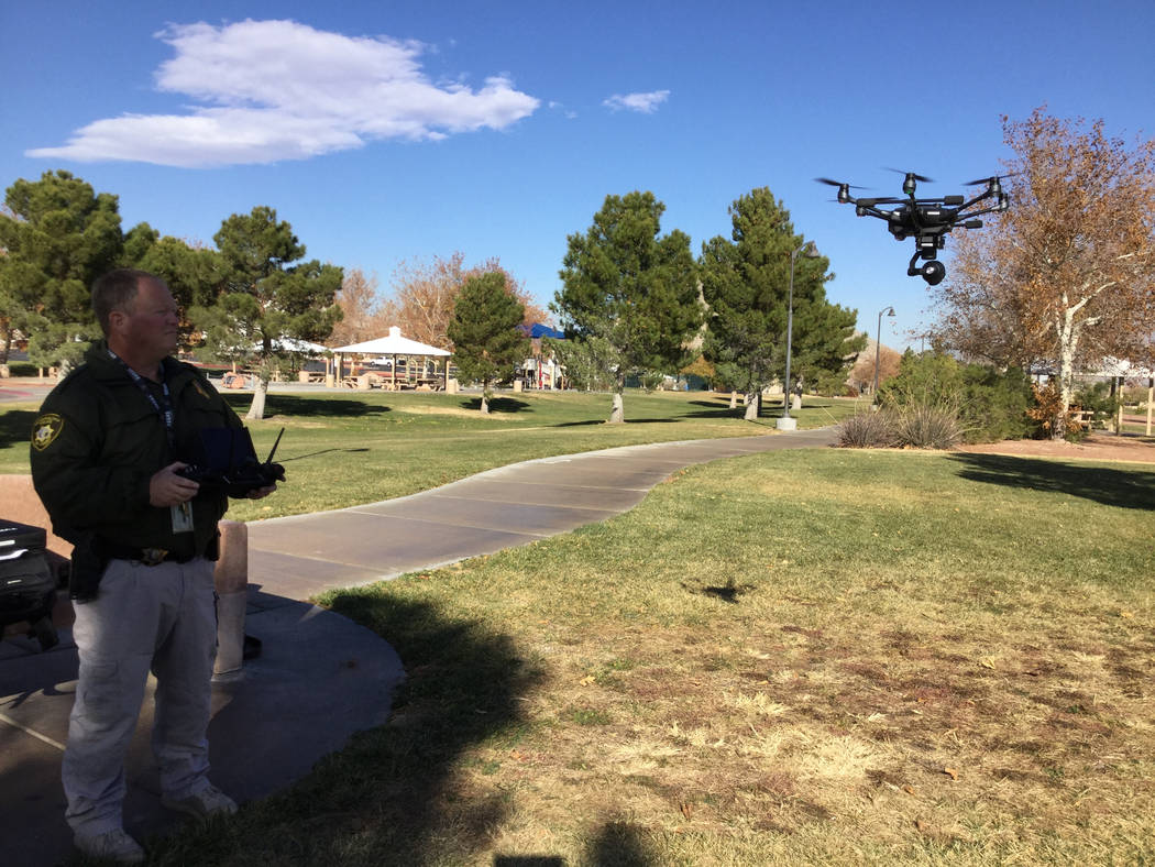
Las Vegas police will use drones to watch over New Year’s Eve celebrations on the Strip, technology the department was not able to use the night of the Oct. 1 mass shooting. Officer David Martel said the department will use two drones — a Yuneec H520 and a Yuneec Typhoon 4 — to monitor crowds, identify suspicious packages and track any unusual activity on Strip properties. Martel said the unmanned aerial vehicles also will check hotel windows for anyone who might try to copy the events of Oct. 1, when a gunman shattered the windows of his 32nd-floor suite at Mandalay Bay and sprayed bullets on 22,000 concertgoers at a nearby outdoor music festival. The gunman killed 58 people and injured more than 500 others before killing himself. “The biggest thing is to provide support to our officers and to provide a better aerial view,” Martel said Wednesday. “It’s hard to get the helicopter along the Strip. Drones are a lot smaller, and you’re able to get into tighter areas.” Those tighter areas might be especially helpful to get a closer look at unaccompanied packages, for example, he said. Having the drones monitor crowds from an aerial view also will help police better position barricades and other pedestrian control devices, he said.
Metro drone use Metro purchased five drones from Yuneec earlier this year for $15,000. Martel estimated the drones arrived Sept. 27, just days before the mass shooting. They were still in unopened boxes in a hangar at the North Las Vegas airport when the shooting occurred. He headed to the hangar as quickly as he could when he got word of the shooting Oct. 1, hoping to use the drones to support first responders. But the drones arrived to the department fresh from the manufacturer. The batteries weren’t charged. Martel said it would have taken an hour to get them fully charged, and the gunfire lasted for about 10 minutes. Had Martel been able to take a fully charged drone with him the night of the shooting, he said he would have used it to locate people who needed help — at least one of the drones is equipped with thermal imaging sensors. Others have a much broader vision for how drones could have helped police address the shooter on Oct.1 — though current policy and technology would have to evolve to support this vision.
Active-shooter situations The day after the shooting, Martel used one of the department’s drones to create a 3-D map the crime scene. “You can kind of re-enact a scene, in some aspects,” he said. “It’s documenting evidence,” like the locations of shell casings. Had Martel gotten to the scene of the crime much, much earlier, he said the drone could have been used to gather information about what was happening and where. Metro initially estimated that it took 72 minutes from the first 911 call for law enforcement to the moment police breached the shooter’s hotel room on the 32nd floor of Mandalay Bay, though the timeline is still under review. Police began searching the hotel’s 29th floor before determining the gunman was on the 32nd floor. “Think about how useful a drone might have been if we have situations like this (Las Vegas shooting) now for large events,” Brian Levin, director of The Center for the Study of Hate and Extremism at California State University-San Bernardino, told the Los Angeles Daily News in October. “You have a guy on the 32nd floor (of a hotel), a drone could have provided real-time intelligence and surveillance to what’s going on.” However, knowing exactly where the gunman was might have been hard to pinpoint, Martel said, because every building has different ways of classifying levels. For instance, some resorts might mark the ground level as lobby instead of as the first floor, or the second level as mezzanine.
A broader vision Ryan Wallace, a professor at Polk State College in Lakeland, Florida, envisions a much broader use for drones in situations like the Oct. 1 shooting. “When you look at the (gunman Stephen) Paddock scenario, you have about 10 minutes of serious carnage. If you have a distraction created by a drone, you could have bought critical moments that could have saved lives,” Wallace told the Review-Journal. In an October paper Wallace co-authored with Jon Loffi, a professor at Oklahoma State University, in the International Journal of Aviation, Aeronautics and Aerospace, Wallace and Loffi advocated using drones for tactical operations, and even equipping drones with nonlethal equipment, like tear gas or smoke canisters. “It’s a very unanticipated type of response from law enforcement,” Wallace said. “When you’re dealing with any scenario, and especially one as well-planned as Paddock had clearly taken the effort to plan, an unexpected tactical response, like a drone, probably would have created a distraction.” For those few seconds, the gunman may have redirected his fire to shoot at the drone, or if he was impacted with something like tear gas he may have taken a break from firing at all. Surprise responses can allow “a tactically poor situation to be turned into a tactically superior situation,” Wallace said.
A while out Nevada is one of five states that ban the use of weaponized drones — North Carolina, Oregon, Vermont and Wisconsin are the others, according to the National Conference of State Legislatures. Two others, Maine and Virginia, ban law enforcement from using them altogether, according to the organization. The Nevada law prohibits a drone from being “weaponized” and makes it unlawful for a person to operate “a weaponized unmanned aerial vehicle.” Violators can be found guilty of a category D felony. Nevada Gov. Brian Sandoval told the Review-Journal in early December that weaponizing drones is “something that Metro should look at.” “We should take advantage of all advances in technology to make sure that people are as safe as they possibly can be,” Sandoval said, adding that weaponizing drones is something he would like to discuss further. Martel said equipping a drone with temporary blinding lights, tear gas or smoke canisters falls into a gray area. Are those considered weapons or tools? The Nevada law does not define what constitutes a weapon. North Dakota is the only state that allows police to use weaponized drones but limits the use to “less lethal” weapons such as stun guns. There are currently no federal regulations against owning an armed drone.
Five drones Metro purchased five drones from Yuneec for $15,000. Officer David Martel, Metro’s small unmanned aerial system program manager, said that figure includes all of the drone equipment, such as blades, batteries and chargers. He said it took the department three years to get everything in place to be able to have drones, including developing internal drone handling polices. Martel estimated the drones arrived Sept. 27, just days before the Oct. 1 Las Vegas shooting. The five drones are spread across three of Metro’s units: crime scene investigation, fatal and armor. Story, video and photo gallery ➤ https://www.reviewjournal.com
A Savage company that distributes drone services has entered a billion-dollar market: agriculture. In 2016, Minnesota’s corn and soybean crops generated more than $9 billion in revenue, according to the University of Minnesota. It seems a lucrative place for any business offering solutions to the industry. Maverick Drone Systems is an unassuming-looking company tucked away in a business park on Eagle Creek Parkway in Savage, not far from Highway 13, one of the southwest metro area’s heaviest-traveled highways. From its location, Maverick sells drones and related services nationwide in law enforcement, fire departments, commercial and residential real estate, oil and other industries. And now agriculture. Maverick is the third company in the country to sell drones that spray herbicide and pesticide on crops, said Joe Elling, Maverick Drone Systems’ unmanned aircraft systems operator and flight coordinator. So it’s the third company in the U.S. solving an expensive problem for farmers. Spraying pesticide and herbicide on crops can be dangerous work. When planes fly that low to the ground, accidents can happen very easily, not to mention how risky it can be handling poison, Elling said. Insurance to cover pilots can be expensive, he said. “Crop spraying is a very dangerous operation,” he said. “Your job is constantly putting your life at risk.”
New technology Maverick sought an exemption from Federal Aviation Administration rules written back in the 1980s, long before drones’ existence. Specifically, Maverick wanted an exemption from a rule about how agriculture aircrafts can dispense poison that treats soil or crops. The rule simply doesn’t apply to the company because they fly unmanned aircraft. “[The FAA] didn’t ever think there was going to be an unmanned aircraft,” Elling said. The FAA agreed with Maverick and made the exemption, which allowed them to move forward with sales. The FAA now has a variety of regulations and initiatives regarding drones, which Elling calls “the wave of the future.” Maverick also has the right technology in place for this venture. About a year and a half ago, new drones that can dispense and spray liquid — such as herbicide and pesticide — entered the market. Maverick imports the drones from China. These drones can be far more specific and targeted than a pilot can. Drones can fly to see where a problem is in a crop, and what bug or plant is causing the issue. This is easier and faster work than a human pilot could conduct, Elling explained. “This new revolution… will really inspire users,” said Adam Shaw, owner and founder of Maverick.
2018 plans Maverick plans to sell products and services for the next growing season in 2018. The company plans to either coach farmers on how to use the technology or offer it as a service, Shaw said. “We can go anywhere in the U.S. now and apply this for farmers,” Shaw said. “Minnesota’s a big farming community. We’ve got a lot to do in this state alone.” The business has grown quickly in just three years. It started in 2014 in commercial real estate. For example, drones make land inspection easier, Shaw explained. And now Maverick has expanded to a variety of industries. They’re working with law enforcement agencies across Minnesota and the Twin Cities metro area, including the Dakota County Sheriff’s Office, Hennepin County and the Shakopee Mdewakanton Sioux Community. Shaw said Chinese manufacturers are “moving ridiculously fast,” with new drone technology coming out every one to three months. Coupled with Maverick’s ambitious goals to one day become the Verizon for drones, the company is positioned for takeoff. “We want to grow Maverick’s brand nationally,” Shaw said. Story and slideshow ➤ http://www.swnewsmedia.com
(SHEPPARD AFB) - Officials with Sheppard Air Force Base want to build up its defense against drones, reminding new users that they can be a flight risk. Airfield Operations Flight Commander, Captain Hollis Troxel said, "Because the drone can still interfere with aircraft operations, we take it very seriously here in making sure that we keep them at their altitude that they're supposed to be operating at." Wichita County Deputy Chief Derrald Choate said the restriction extends beyond flying on base. He added, "Anywhere around Sheppard Air Force Base, you have to stay at least a 5 mile radius away." "We do about 240 sorties a day out of here and that's a lot of departing and landing of aircraft and when drones become involved with aircraft," Captain Troxel added, "It can become very dangerous." To keep the airspace safe, the FAA also restricts all drones being flown above 400 feet in altitude and if a trespassing drone is deemed a threat, Captain Troxel told us, "Security forces would obviously react, seize the drone and then they would have to work with the local PD as far as what actions to be taken against the pilot of the drone." There's also an app for that. Captain Troxel mentioned, "B4UFLY app that's developed by the FAA, actually indicates Sheppard Air Force Base as a no-fly area for drones and we'll tell you based on your location if you are within 5 miles of the airfield and what number to actually contact." Sheppard has yet to encounter an unmanned aircraft and officials told us that the Wichita Falls community is to thank. "The community's very helpful. They have a drone park that's down by Lucy Park. A lot of our drone users in the area will actually use that as their base of operation." If a drone flies under your Christmas tree, Sheppard officials and area law enforcement hope these tips stop you from becoming a drone intruder. Lastly, Captain Troxel also said to simply call the base's tower to notify them of where you may be flying a drone, the type of drone you may be flying and how high you will be going. Story and video ➤ http://www.texomashomepage.com
Riverside residents Ashley Carroll, 31, and Benjamin Baldassarre, 39, were allegedly involved in selling illegal drugs with use of a drone.
RIVERSIDE, Calif. (KABC) -- Riverside police arrested two people they say were involved in a drug operation that involved delivering narcotics by a drone. When officers raided the alleged drug house, they say they found narcotics scattered all around, including a vape pen containing marijuana found in the bedroom of a 9-year-old girl. The raid of the house was preceded by a surveillance operation that began when officers learned of individuals selling drugs using a drone. Officers say they saw a drone leave the back yard of a home in the 8700 block of Chesapeake Lane, fly to a nearby parking lot and drop a package of drugs to waiting customers. On Thursday, officers served a warrant on the home where the drone was seen. They say they found drugs throughout the home, in addition to used, uncapped needles scattered throughout a bedroom. They also say they found unpackaged powders believed to contain the drug fentanyl. They also say they found methamphetamine, candies laced with LSD and the drone. They also found a vape pen with marijuana in the bedroom of a 9-year-old girl living at the home. Protective Services was called in and eventually the child was released to her mother. Police arrested two Riverside residents associated with the residence: Benjamin Baldassarre, 39, and Ashley Carroll, 31. They were booked for possession of controlled substances, possession of controlled substances for the purposes of sales, conspiracy to commit a crime, and child endangerment. Story and photo ➤ http://abc7.com
LADUE, Mo. – Some Ladue residents have asked Mayor Nancy Spewak how the city will regulate privacy and drone usage as the it moves into the future. Ladue is expanding its peeping Toms ordinance to now cover drone usage. This prohibits people from peering into the windows others buildings and houses without a visible or lawful purpose. “I think this was most enforceable ordinance we could put forth was the window peeping,” Spewak said. “We already had it on the books and we just put electronic devices in there.” The mayor said the city hasn’t experienced any problems with drones or complaints, but they just want to get out in front of it. “We've been very proactive,” she said. “It’s on everyone’s mind because everyone is talking about drones and in the future.” Ladue wanted an enforceable ordinance for police to prevent drones from flying around on private property without permission of the property owners. “This is not meant to stop package delivery in the future by drone; and real estate agents use drones to show property,” Spewak said. The mayor said she believes a few other local cities have enacted similar ordinances and this is all about protecting citizens. “I just think it’s important that residents understand that we take their concerns seriously and that we always want to be proactive in protecting their privacy,” she said. Story and video ➤ http://fox2now.com
An employee from Boeing contacted police Nov. 14 to report someone had stolen a drone from the Boeing store on Park Avenue North. Surveillance footage shows three men entering the store and looking around. When the store clerk was distracted, one of the men took the drone and walked out of the door, followed by the other door. The video wasn’t clear enough to help officers positively identify the suspects. There is no further suspect information at this time. Original article can be found here ➤ http://www.rentonreporter.com
On a snowy logging road near Sacheen Lake, Jason Hanlon stares intently at his iPad. He’s searching for a moose. Roughly 700 feet away, up a rugged wooded hillside, his drone hovers 390 feet off the deck. From that height, the trees and underbrush look like a painting – two-dimensional outlines and colors. Then he spots her. A moose, bedded down in a patch of trees. Hanlon maneuvers the drone down until it’s hovering roughly 50 feet off the ground. The video streaming back to the iPad is crystal clear. The moose occasionally glances up at the buzzing object. As the drone drops closer, she ambles away. Moose, with no natural aerial predators, don’t care much about drones. “OK,” Hanlon said. “I’m going to come back. We did what we came to do.” He documented a moose. This week, for the first time, the Washington Department of Fish and Wildlife used a drone to survey moose populations in northeast Washington. The weeklong test will help determine how and if the agency uses drones in the future, a question wildlife biologist across the world are considering. Based on the wildlife biologists’ banter after the drone’s successful excursion, the technology is a hit. “(That was) much quicker than on foot,” said Jared Oyster, a WDFW wildlife biologist who coordinates moose survey work in eastern Washington. “We’d still be hiking up there.” Seth Boogaard, a field technician, chimes in: “I betcha if I walked in there she would have bust.”
The whole Thursday-morning operation took roughly 30 minutes. Much faster than a normal moose approach. “We didn’t even have to sweat for that one,” Boogaard said. Normally, it’s not that easy. Since the winter of 2013-14 James Goerz, a University of Montana doctoral student, has been tracking and monitoring radio collared moose as part of a multiyear study. The study was designed to shed some light on how and why Washington’s moose population has grown over the past decades. It also anticipates a time when the population declines. “It seemed clear the moose population was increasing but would not (increase) forever,” said Rich Harris, the state’s manager for special big-game species. Harris accompanied Goerz into the field Thursday to observe the drone in action. Moose first came to Washington from Canada and Idaho six decades ago. The first confirmed moose sighting was made in Pend Oreille County in the early 1950s. Surveys in the early 1970s estimated a population of about 60 moose. The first hunting season was opened in 1977. Since then, the population has grown. Between 4,000 and 6,000 moose live in Washington, despite the fact that in other parts of the country populations have declined – down as much as 70 percent in Minnesota. A recently study out of Minnesota indicates that parasites carried by deer in Minnesota’s North Woods are the leading cause of moose death. The Washington study is looking at how predation, climate change, ecology and other factors impact the moose population in Washington. “It’s pretty likely that all these factors interact,” Harris said. As part of the study, researchers track the 35 radio-collared moose year-round. They look to see if the cows have calves and how long the animals survive. Per research protocol, the biologists have to lay eyes on the animals three times per year. The Northeast Washington Moose Demography Project is Goerz’s doctoral project. Field work is expected to end in May and Goerz hopes to defend his dissertation in early 2020. Since the start of the project, Goerz said he and his staff have done more than 1,200 moose approaches, requiring hours of diligent, discrete trekking. Approaches that 60 percent of the time don’t end with a moose sighting. Often, Goerz said, he’ll be so close to the animals he can hear their breath. But unless he can clearly see them and their calf, it’s no good. “Yeah, you have to be OK with failure when it comes to moose work,” Goerz said. The drone could make this work easier. “For our purposes, I think it will help,” Goerz said. Drone use only became possible in Washington this year after the state Legislature allowed state agencies to draft drone use policies. Concerns about liability and privacy had prevented that from happening in the past. Originally, Goerz said he hoped to fly the drone in October, but because he didn’t want to disturb hunters they decided to wait a month. “A lot of these agencies don’t even have protocols for these drones,” said Jason Hanlon, the drone operator. Hanlon owns his own company, ExploreUAS, specializing in drone video, photography and mapping. The Montana resident contracted with WDFW to test the drone use for five days, which ended Friday. “This isn’t a toy,” he said about drones. “It’s a data collecting machine.” Worldwide wildlife biologists are beginning to explore how drones can assists their research and conservation efforts. According to a 2017 article in Popular Science, the leading cause of job-related death for wildlife biologists is in small plane or helicopter crashes, making drones a cheaper and safer alternative. In Washington, drones could be especially useful for surveying Washington’s goat population, a species known for living in hard-to-access locales. “Everything we do of any effectiveness in this state with goats is done with a helicopter,” Harris said. Drones are generally less stressful to animals than a foot approach or a helicopter fly-by. Moose only appear to notice the machine’s presence once it’s close to the ground. While they walk away from the buzzing annoyance, they don’t bolt. “It’s not accurate to say there is no disturbance at all,” Harris said. “But, again, compared to the alternative, it’s clearly less disturbance.” Drones do have their weaknesses. After Thursday’s first successful flight, the research team drove to a higher elevation searching for another collared moose. It quickly became too cold and foggy for the drone to fly, with its wings icing up in the cold damp air. Hanlon, fearing a crash, grounded his drone as conditions got colder and foggier. That forced Goerz and his team to strike out on foot again. The target moose was in thick snow-covered brush between two steep roads near Winchester Creek in the Colville National Forest. Goerz, a pro after thousands of hours of practice, spaced three observers out along the lower road. Boogaard and Oyster hiked uphill and worked their way down trying to flush the moose on to the road. After an hour or so, the animal popped out of the underbrush and was briefly spotted. She had no calf. Two moose in one day. That’s a good day, Goerz said. Story, photo gallery and video ➤ http://www.spokesman.com

 4C Drone Solutions LLC co-owner C.J. Carlock
 4C Drone Solutions LLC co-owner Chad Cox.