Investigator In Charge (IIC): Williams, David
The National Transportation Safety Board did not travel to the scene of this accident.
Additional Participating Entity:
Nelson Wolfmeier; Federal Aviation Administration / Flight Standards District Office; Denver, Colorado
Thunderbird Aviation LLC
Journeys Aviation
Location: Fort Collins, Colorado
Accident Number: CEN22LA414
Date and Time: September 11, 2022, 18:59 Local
Registration: N9049H
Aircraft: Cessna 172M
Aircraft Damage: Substantial
Defining Event: Collision with terr/obj (non-CFIT)
Injuries: 2 Minor
Flight Conducted Under: Part 91: General aviation - Personal
Analysis
A pilot and flight instructor were conducting a personal flight over a reservoir when they descended and flew at a low altitude over two boats on the water. After passing the second boat, they turned west into a cove and impacted rising terrain about 1 mile west of the shoreline, which resulted in substantial damage to the fuselage and both wings.
Following the accident, the flight instructor made differing and conflicting statements to the National Transportation Safety Board (NTSB). The first statement was that there was an engine malfunction and to avoid landing on the water or impacting boats on the surface, he elected to make a climbing right turn to the west, away from the lake, and the airplane subsequently impacted rising terrain. In a written statement provided by the flight instructor, he stated that the power had been reduced to “see more of the scenery.” Shortly thereafter, the pilot flying told him that he could not climb due to a jammed elevator. The flight instructor stated that he could only control the airplane through the use of trim and power manipulation. To avoid congested areas, they maneuvered to the reservoir and attempted to free the jammed elevator by “wiggling the flight control in and out,” which resulted in the airplane pitching down. He stated that after adding power and retrimming the airplane, he elected to fly west into the
valley to look for a landing area.
A review of flight track data revealed that the airplane did not descend as described in the written statement, but instead flew east to west over the reservoir and descended during a 270° turn over the reservoir that was initiated about mid-channel. The airplane traversed about 1.6 miles south along the reservoir before it turned west and climbed. The last recorded altitude was about 6,075 ft msl near the accident location.
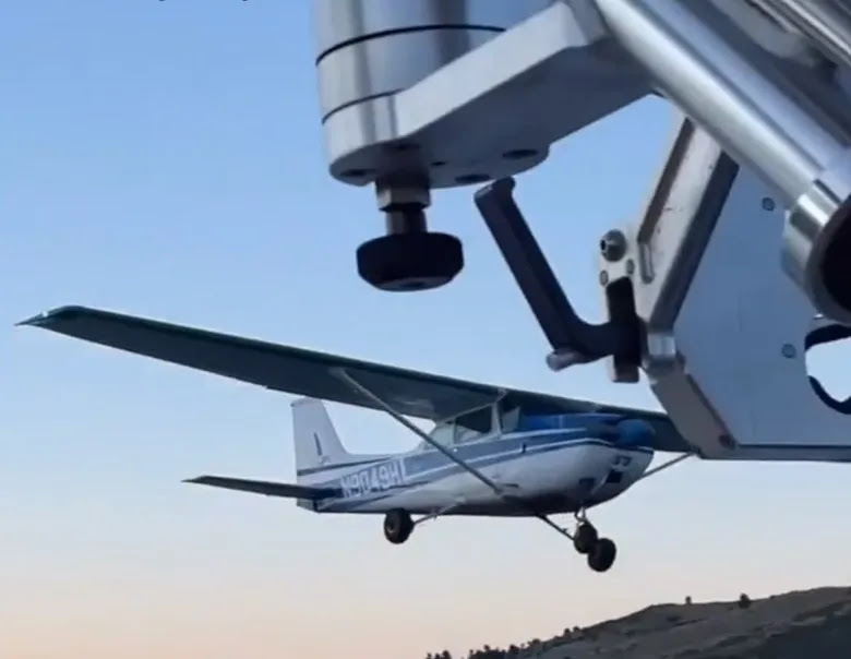
Photographs provided by a witness show the airplane low over the water as it approached one of only three visible boats. At first, the airplane appeared headed toward the shore, but made a left turn toward the first boat. After making a very low pass over the boat, the airplane made a steep climb, followed by a steep right turn, and then flew at a low altitude over the second boat. After passing the second boat, the airplane appeared to depart toward a valley.
Postaccident examinations by the Federal Aviation Administration and the NTSB revealed no mechanical malfunctions or anomalies that would have precluded normal operation of the engine or flight controls.
Probable Cause and Findings
The National Transportation Safety Board determines the probable cause(s) of this accident to be:
The pilot’s failure to maintain clearance from rising terrain while intentionally maneuvering the airplane at low altitudes, which resulted in substantial damage to the fuselage and both wings.
Findings
Personnel issues Decision making/judgment - Pilot
Environmental issues Mountainous/hilly terrain - Contributed to outcome
Factual Information
History of Flight
Maneuvering Collision with terr/obj (non-CFIT) (Defining event)
On September 11, 2022, about 1859 mountain daylight time, a Cessna 172 airplane, N9049H, sustained substantial damage when it was involved in an accident near Fort Collins, Colorado. The pilot and flight instructor sustained minor injuries. The airplane was operated as a Title 14 Code of Federal Regulations Part 91 personal flight.
During an initial telephone interview with the National Transportation Safety Board on September 12, the flight instructor stated that during the flight over Horsetooth Reservoir, an engine power issue had occurred. He stated that in an effort to avoid landing on the water or impacting boats on the surface, he elected to make a climbing right turn to the west, away from the lake, and the airplane impacted rising terrain.
In a written statement provided by the flight instructor on September 15, he reported that he and his brother (who was also a certificated pilot) were flying the airplane east of the Horsetooth Reservoir, between Fort Collins and the reservoir, and his brother reduced power to “observe more of the scenery.” Shortly after reducing the power, his brother told him that he could not climb due to a jammed elevator. The flight instructor stated that he took control of the airplane and confirmed that the elevator was jammed, and he used power and trim to climb. In an effort to avoid congested areas, they maneuvered to the reservoir and attempted to free the jammed elevator by “wiggling the flight control in and out,” which resulted in the airplane pitching down. He stated that after adding power and retrimming the airplane, he elected to fly west into the valley to look for a landing area. Unable to outclimb the rising terrain, the airplane impacted a tree and the rising terrain, which resulted in substantial damage to the fuselage and both wings.
Flight track data for this report was obtained from L3/Harris OpsVue, a commercially available web base product that aggregates and geo-references Federal Aviation Administration (FAA) data sources including data from FAA ASDE-X and ASSC systems, FAA terminal and en route radars, the FAA certified ADS-B Network and flight plan data from the En Route Automation Modernization (ERAM) system. The accident airplane was squawking a non-discreet beacon code of 1200 and positive identification could not be made. However, the flight track data obtained was consistent with the reported departure time and airport, and the flight track ended near the recorded accident location (figure 1). A review of the data revealed that the airplane was about 6,550 ft above mean sea level (msl) when it crossed the east bank of the reservoir headed west. After it crossed about mid-channel, the airplane turned right, about 270° while descending to an altitude below 5,500 ft msl (floor of coverage). Due to being below the floor of coverage, flight track and altitudes ceased to record. When the airplane was reacquired, the position was about 1 mile south at an altitude of about 5,375 ft msl. The airplane traversed about 1.6 miles south along the reservoir before it turned west and climbed.
The last recorded altitude was about 6,075 ft msl near the accident location.
Photographs provided by a witness show the airplane low over the water as it approached one of only three visible boats. At first, the airplane appeared headed toward the shore, but made a left turn toward the first boat (figures 2 and 3). After making a very low pass over the boat (figure 4), the airplane made a steep climb, followed by a steep right turn (figure 5), and then low over the second boat (figure 6). After passing the second boat, the airplane appeared to depart toward a valley.
An FAA air safety inspector completed an on-scene examination of the airplane. During the examination, flight control continuity was established from the control yokes to the elevator control surface with no binding or mechanical anomalies noted. A visual examination of the other flight controls revealed no anomalies that would have precluded normal operation.
During a postaccident examination conducted by the NTSB, flight control continuity was established from the control yokes, through recovery cuts to all flight control surfaces with no binding or mechanical anomalies notes. The engine was examined, and no mechanical malfunctions or anomalies were found that would have precluded normal operation.
Flight instructor Information
Certificate: Airline transport; Flight instructor
Age: 34,
Airplane Rating(s): Single-engine land; Multi-engine land
Seat Occupied: Right
Other Aircraft Rating(s): Unmanned (sUAS)
Restraint Used: 3-point
Instrument Rating(s): Airplane
Second Pilot Present: Yes
Instructor Rating(s): Airplane multi-engine; Airplane single-engine; Instrument airplane
Toxicology Performed:
Medical Certification: Class 1 Without waivers/limitations
Last FAA Medical Exam: January 3, 2022
Occupational Pilot: Yes
Last Flight Review or Equivalent: June 11, 2022
Flight Time: 3580 hours (Total, all aircraft), 337 hours (Total, this make and model), 2571 hours (Pilot In Command, all aircraft), 72 hours (Last 90 days, all aircraft), 22 hours (Last 30 days, all aircraft), 1.5 hours (Last 24 hours, all aircraft)
Pilot Information
Certificate: Commercial
Age: 38
Airplane Rating(s): Single-engine land; Multi-engine land
Seat Occupied: Left
Other Aircraft Rating(s): None
Restraint Used: 3-point
Instrument Rating(s): Airplane
Second Pilot Present: Yes
Instructor Rating(s): None
Toxicology Performed:
Medical Certification: None
Last FAA Medical Exam:
Occupational Pilot: Yes
Last Flight Review or Equivalent:
Flight Time: 7000 hours (Total, all aircraft)
Aircraft and Owner/Operator Information
Aircraft Make: Cessna
Registration: N9049H
Model/Series: 172M
Aircraft Category: Airplane
Year of Manufacture: 1975
Amateur Built:
Airworthiness Certificate: Normal
Serial Number: 17265918
Landing Gear Type: Tricycle
Seats: 4
Date/Type of Last Inspection: Certified
Max Gross Wt.:
Time Since Last Inspection:
Engines: 1 Reciprocating
Airframe Total Time:
Engine Manufacturer: Lycoming
ELT: Engine Model/Series: O320
Registered Owner:
Rated Power: 180
Operator:
Operating Certificate(s) Held: None
Meteorological Information and Flight Plan
Conditions at Accident Site: Visual (VMC)
Condition of Light: Day
Observation Facility, Elevation: KFNL, 5015 ft msl
Distance from Accident Site: 9 Nautical Miles
Observation Time: 18:56 Local
Direction from Accident Site: 128°
Lowest Cloud Condition: Clear
Visibility 10 miles
Lowest Ceiling: None
Visibility (RVR):
Wind Speed/Gusts: 5 knots /
Turbulence Type Forecast/Actual: /
Wind Direction: 180°
Turbulence Severity Forecast/Actual: /
Altimeter Setting: 30.22 inches Hg
Temperature/Dew Point: 21°C / 5°C
Precipitation and Obscuration: No Obscuration; No Precipitation
Departure Point: Boulder, CO (KBDU)
Type of Flight Plan Filed: None
Destination: Fort Collins, CO
Type of Clearance: None
Departure Time:
Type of Airspace: Class G
Wreckage and Impact Information
Crew Injuries: 2 Minor
Aircraft Damage: Substantial
Passenger Injuries:
Aircraft Fire: None
Ground Injuries:
Aircraft Explosion: None
Total Injuries: 2 Minor
Latitude, Longitude: 40.546516,-105.17836