Monday, January 03, 2022

Piper PA-46-500TP Malibu Meridian, N619TK: Incident occurred January 02, 2022 at Scottsdale Airport (KSDL), Maricopa County, Arizona

Federal Aviation Administration / Flight Standards District Office; Scottsdale, Arizona

Aircraft on landing veered to the right and over corrected going off the runway into the rocks. 

Blue Sky Aviation Investments LLC 


Date: 02-JAN-22
Time: 17:16:00Z
Regis#: N619TK
Aircraft Make: PIPER
Aircraft Model: PA46
Event Type: INCIDENT
Highest Injury: NONE
Aircraft Missing: No
Damage: UNKNOWN
Activity: PERSONAL
Flight Phase: LANDING (LDG)
Operation: 91
City: SCOTTSDALE
State: ARIZONA

Cessna 152, N89084: Accident occurred December 31, 2021 at Mojave Air and Space Port (KMHV), Kern County, California


This is preliminary information, subject to change, and may contain errors. Any errors in this report will be corrected when the final report has been completed. 

The National Transportation Safety Board did not travel to the scene of this accident. 

Additional Participating Entity:
Federal Aviation Administration / Flight Standards District Office; Van Nuys, California

Investigation Docket - National Transportation Safety Board:

Aero Association of Caltech Inc


Location: Mojave, California 
Accident Number: WPR22LA070
Date and Time: December 31, 2021, 14:00 Local
Registration: N89084
Aircraft: Cessna 152
Injuries: 1 None
Flight Conducted Under: Part 91: General aviation - Personal

Aircraft and Owner/Operator Information

Aircraft Make: Cessna
Registration: N89084
Model/Series: 152 
Aircraft Category: Airplane
Amateur Built:
Operator:
Operating Certificate(s) Held: None
Operator Designator Code:

Meteorological Information and Flight Plan

Conditions at Accident Site: VMC
Condition of Light: Day
Observation Facility, Elevation: K9L2,2283 ft msl 
Observation Time: 13:58 Local
Distance from Accident Site: 15 Nautical Miles 
Temperature/Dew Point: 10°C /1°C
Lowest Cloud Condition: Clear 
Wind Speed/Gusts, Direction: 27 knots / 32 knots, 250°
Lowest Ceiling: None
Visibility: 10 miles
Altimeter Setting: 29.63 inches Hg 
Type of Flight Plan Filed:
Departure Point: 
Destination:

Wreckage and Impact Information

Crew Injuries: 1 None
Aircraft Damage: Substantial
Passenger Injuries: 
Aircraft Fire: None
Ground Injuries: 
Aircraft Explosion: None
Total Injuries: 1 None 
Latitude, Longitude: 35.058944,-118.15061

Cessna R182 Skylane RG, N739CL: Incident occurred January 02, 2022 at Meadow Lake Airport (KFLY), Colorado Springs, Colorado


Federal Aviation Administration / Flight Standards District Office; Denver, Colorado

Aircraft gear collapsed on landing.  


Date: 02-JAN-22
Time: 21:00:00Z
Regis#: N739CL
Aircraft Make: CESSNA
Aircraft Model: 182
Event Type: INCIDENT
Highest Injury: NONE
Aircraft Missing: No
Damage: UNKNOWN
Activity: PERSONAL
Flight Phase: LANDING (LDG)
Operation: 91
City: COLORADO SPRINGS
State: COLORADO

Zenith STOL CH750, N750DP: Accident occurred January 02, 2022 in Montrose, Colorado

This is preliminary information, subject to change, and may contain errors. Any errors in this report will be corrected when the final report has been completed. 

The National Transportation Safety Board did not travel to the scene of this accident.

Additional Participating Entity:
Federal Aviation Administration / Flight Standards District Office; Denver, Colorado


Location: Montrose, Colorado
Accident Number: CEN22LA093
Date and Time: January 2, 2022, 10:40 Local
Registration: N750DP
Aircraft: Zenith CH750 
Injuries: 1 None
Flight Conducted Under: Part 91: General aviation - Personal

On January 02, 2022, about 1040 mountain standard time, a Zenith CH750, N750DP, was substantially damaged when it was involved in an accident near Montrose, Colorado. The pilot was uninjured. The airplane was operated as a Title 14 Code of Federal Regulations (CFR) Part 91 personal flight.

The pilot stated that before taking off for the flight, he added 24 gallons of 92 octane, ethanol free automotive gas to the fuel tanks. After waiting for the fuel to settle, he sumped the fuel tanks and observed no contamination or water. About 30 minutes after departure and while in cruise flight, at an altitude of about 10,500 ft mean sea level, he observed the fuel pressure decrease from 44 pounds per square inch (psi) to 39 psi. It increased to 40 psi, before decreasing to zero at the same time the engine RPMs decreased to zero. For the next 3 to 5 minutes, the fuel pressure and RPMs fluctuated between normal and zero. He activated the backup fuel pump with no effect noted.

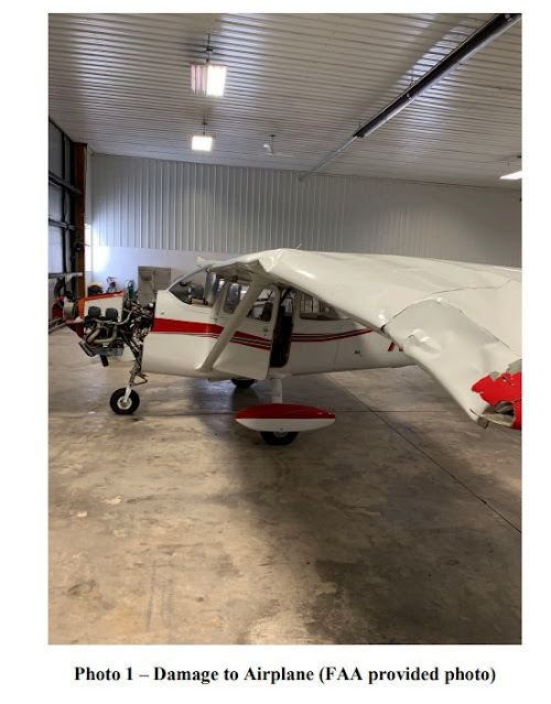
The pilot executed a forced landing on top of a snow-covered plateau about 20 miles south of Montrose. During the landing, the wheels dug into the snow, and the airplane nosed over which resulted in substantial damage to both wings.

The airplane was equipped with a Viking/Honda 110 engine. A detailed examination is pending.

Aircraft and Owner/Operator Information

Aircraft Make: Zenith
Registration: N750DP
Model/Series: CH750
Aircraft Category: Airplane
Amateur Built: Yes
Operator: On file
Operating Certificate(s) Held: None
Operator Designator Code:

Meteorological Information and Flight Plan

Conditions at Accident Site: VMC
Condition of Light: Day
Observation Facility, Elevation: KMTJ, 5720 ft msl 
Observation Time: 09:53 Local
Distance from Accident Site: 18 Nautical Miles
Temperature/Dew Point: -13°C /-18°C
Lowest Cloud Condition: Clear
Wind Speed/Gusts, Direction: 6 knots / , 160°
Lowest Ceiling: None 
Visibility: 10 miles
Altimeter Setting: 30.49 inches Hg
Type of Flight Plan Filed:
Departure Point: Poania, CO (7V2)
Destination:

Wreckage and Impact Information

Crew Injuries: 1 None 
Aircraft Damage: Substantial
Passenger Injuries: N/A 
Aircraft Fire: None
Ground Injuries: 
Aircraft Explosion: None
Total Injuries: 1 None
Latitude, Longitude: 38.44,-108.28 (est)


Montrose County Sheriff's Office 

FOR IMMEDIATE RELEASE: Pilot Walks Away Unharmed After Small Plane Crash in Montrose County 

Montrose, COLORADO — On the morning of January 2, the Montrose County Sheriff Office received information that a pilot in a private aircraft declared an emergency over the radio. The pilot said his aircraft was going down west of Montrose.

Another private aircraft overheard the radio communication and flew the area in hopes of locating the downed aircraft. The pilot was ultimately able to locate the downed aircraft, a 2010 Zenith CH 750, on the Uncompahgre Plateau, which was upside down in the snow. The second pilot was able to get into radio communication with the pilot and sole occupant of the downed aircraft and provided rough coordinates to the location of the downed aircraft before disengaging and flying to the Montrose Regional Airport.

Montrose County Sheriff’s Office deputies, Montrose County Sheriff’s Posse members, and members of the Montrose Fire Protection District responded to the area to try and locate the downed aircraft via snowmobiles and a side-by-side with snow tracks. Care Flight of the Rockies then launched and flew to the area of the crash site to try and locate the downed aircraft from the air since the remoteness of the crash site would delay the response of ground crews.

Care Flight was able to locate the downed aircraft and dropped snowshoes to the pilot, later identified as 63-year-old Randy Boykin. Care Flight was able to land nearby and Mr. Boykin, who miraculously didn’t sustain any life-threatening injuries, was able to walk out to meet Care Flight and he was transported to his home-base airport east of Delta.

“It is incredible that the pilot only sustained minor injuries and we are extremely grateful for this outcome, as it could have been much worse,” said Montrose County Sheriff’s Office Commander Ty Cox. “Mr. Boykin did an outstanding job attempting to land the aircraft in an area free of any trees or other hazards. We are very grateful to our partners and the private pilot who overheard the initial call of distress in the successful rescue of Mr. Boykin.”

Mr. Boykin later contacted the Montrose County Sheriff’s Office and said that his aircraft had a mechanical issue, which caused him to crash after losing power. Per protocol, the National Transportation Safety Board (NTSB) and Federal Aviation Administration (FAA) will be conducting the crash investigation.

=======

MONTROSE, Colorado (KREX) — The Montrose County Sheriff Office received information on the morning of January 2 that a pilot in a private aircraft declared an emergency over the radio. The pilot said his aircraft was going down in the area west of Montrose.

Another private aircraft overheard the radio communication and flew to the area in hopes of locating the downed aircraft. The pilot was ultimately able to locate the 2010 Zenith CH 750 on the Uncompahgre Plateau, which was upside down in the snow. The second pilot was able to get into radio communication with the pilot of the downed aircraft and provide rough coordinates of the downed craft before disengaging.

Montrose County Sheriff’s Office deputies, Montrose County Sheriff’s Posse members, and members of the Montrose Fire Protection District responded to the area to try and locate the downed aircraft using snowmobiles and a side-by-side with snow tracks. Care Flight of the Rockies then launched and flew to the area of the crash site to try and locate the downed aircraft from the air since the remoteness of the crash site would delay the response of ground crews.

Care Flight was able to locate the downed aircraft and dropped snowshoes to the pilot, later identified as 63-year-old Randy Boykin. Care Flight was able to land nearby and Mr. Boykin, who miraculously didn’t sustain any life-threatening injuries, was able to walk out to meet Care Flight and he was transported to his home-base airport east of Delta.

“It is incredible that the pilot only sustained minor injuries and we are extremely grateful for this outcome, as it could have been much worse,” said Montrose County Sheriff’s Office Commander Ty Cox. “Mr. Boykin did an outstanding job attempting to land the aircraft in an area free of any trees or other hazards. We are very grateful to our partners and the private pilot who overheard the initial call of distress in the successful rescue of Mr. Boykin.”

Mr. Boykin later contacted the Montrose County Sheriff’s Office and said that his aircraft had a mechanical issue, which caused him to crash after losing power.

Per protocol, the National Transportation Safety Board (NTSB) and Federal Aviation Administration (FAA) will be conducting the crash investigation.


GRAND JUNCTION, Colorado (KJCT) - Sunday morning, the Montrose County Sheriff’s Office received reports of a small aircraft going down west of Montrose.

The pilot, 63-year-old Randy Boykin, was flying a private aircraft and was the only occupant onboard. Boykin declared an emergency over the radio, saying his aircraft was going down, he was overhead by another private aircraft flying nearby. The second pilot was able to locate the downed aircraft, a 2010 Zenith CH 750, which had landed upside-down in the snow on the Uncompahgre Plateau.

The second pilot was able to contact Boykin and provided rough coordinates to the downed aircraft to authorities before disengaging and flying to the Montrose Regional Airport.

The MCSO, Montrose County Sheriff’s Posse members, and members of the Montrose Fire Protection District all responded to the area of the downed aircraft via snowmobiles and a side-by-side outfitted with snow tracks.

Care Flight of the Rockies also flew out to the crash site to help locate the downed aircraft due to the remoteness of its location and the delay land crews would have in reaching Boykin.

Care Flight was successful in locating the downed aircraft and dropped snowshoes down to Boykin. Care Flight was then able to land nearby and Boykin walked out to meet them uninjured. He was later transported to his home-base airport east of Delta.

“It is incredible that the pilot only sustained minor injuries and we are extremely grateful for this outcome, as it could have been much worse,” said Montrose County Sheriff’s Office Commander Ty Cox. “Mr. Boykin did an outstanding job attempting to land the aircraft in an area free of any trees or other hazards. We are very grateful to our partners and the private pilot who overheard the initial call of distress in the successful rescue of Mr. Boykin.”

Boykin reports his aircraft had a mechanical issue causing him to crash after losing power.

The National Transportation Safety Board and Federal Aviation Administration is leading the investigation into the crash.

Mooney M20C Ranger, N79396: Accident occurred January 01, 2022 in Southeast Arcadia, DeSoto County, Florida

This is preliminary information, subject to change, and may contain errors. Any errors in this report will be corrected when the final report has been completed.
 
The National Transportation Safety Board did not travel to the scene of this accident. 

Additional Participating Entity:
Federal Aviation Administration / Flight Standards District Office; Tampa, Florida


Location: Southeast Arcadia, Florida
Accident Number: ERA22LA099
Date and Time: January 1, 2022, 12:11 Local
Registration: N79396
Aircraft: Mooney M20C 
Injuries: 2 None
Flight Conducted Under: Part 91: General aviation - Personal

On January 1, 2022, about 1211 eastern daylight time, a Mooney M20C, N79396, was substantially damaged when it was involved in an accident near Arcadia, Florida. The private pilot and passenger were not injured. The airplane was operated as a Title 14 Code of Federal Regulations Part 91 personal flight.

According to the pilot, he performed a preflight and verified he had sufficient fuel onboard for his flight. After an uneventful flight he entered the traffic pattern for runway 24. While on final approach about 300 to 400 ft, he reported the airplane “experienced some sink.” He added power and when the engine did not respond he pumped the throttle to no avail. He verified 4 gallons of fuel was in the right tank, and the boost pump was ON. Unable to make the runway he performed a forced landing in a field adjacent the runway. During touchdown the right wing clipped a tree and was substantially damaged.

The airplane and engine were recovered for further examination.

Aircraft and Owner/Operator Information

Aircraft Make: Mooney
Registration: N79396
Model/Series: M20C
Aircraft Category: Airplane
Amateur Built:
Operator: On file 
Operating Certificate(s) Held: None
Operator Designator Code:

Meteorological Information and Flight Plan

Conditions at Accident Site: VMC 
Condition of Light: Day
Observation Facility, Elevation: PGD,25 ft msl 
Observation Time: 12:53 Local
Distance from Accident Site: 19 Nautical Miles 
Temperature/Dew Point: 28°C /19°C
Lowest Cloud Condition: Few / 3700 ft AGL 
Wind Speed/Gusts, Direction: 11 knots / , 210°
Lowest Ceiling: 
Visibility: 10 miles
Altimeter Setting: 30.06 inches Hg 
Type of Flight Plan Filed:
Departure Point: Brooksville, FL (X05)
Destination: Southeast Arcadia, FL

Wreckage and Impact Information

Crew Injuries: 2 None 
Aircraft Damage: Unknown
Passenger Injuries: 
Aircraft Fire: None
Ground Injuries: 
Aircraft Explosion: None
Total Injuries: 2 None 
Latitude, Longitude: 27.20004,-81.830592


DeSoto County Sheriff's Office

Deputy Robert Wilds and Detective James Albritton responded Saturday afternoon to SE Highway 31 in reference to a plane crash.  

After speaking to the pilot, Gregory Taylor, it seems he and his wife left Springhill, Florida, earlier that morning and planned on landing at Arcadia Municipal Airport to refuel.  

Everything was going according to plan until the plane lost power on final landing. 

Mr. Taylor knew he had to make an emergency landing and, after determining there were too many vehicles on the roadway, chose a nearby orange grove. 

DeSoto County Fire Rescue - Administrative Office and DeSoto County Sheriff's Office worked together to secure the scene.

This all could've ended very differently. 

We are just so thankful everyone was ok... and for obliging orange groves.

DeSoto County Sheriff's Office

Eclipse 500, N227UH: Incident occurred January 01, 2022 at Goodland Municipal Airport (KGLD), Sherman County, Kansas

Federal Aviation Administration / Flight Standards District Office; Wichita, Kansas

Aircraft landed with nose gear partially extended.  

U-Haul Company of Oregon 


Date: 01-JAN-22
Time: 18:30:00Z
Regis#: N227UH
Aircraft Make: ECLIPSE
Aircraft Model: EA500
Event Type: INCIDENT
Highest Injury: NONE
Aircraft Missing: No
Damage: MINOR
Activity: PERSONAL
Flight Phase: LANDING (LDG)
Operation: 91
City: GOODLAND
State: KANSAS

Piper PA-24-250 Comanche, N5844P: Accident occurred January 02, 2022 at Grand Forks International Airport (KGFK), North Dakota

This is preliminary information, subject to change, and may contain errors. Any errors in this report will be corrected when the final report has been completed. 

The National Transportation Safety Board did not travel to the scene of this accident. 

Additional Participating Entity:
Federal Aviation Administration / Flight Standards District Office; Fargo, North Dakota


Location: Grand Forks, North Dakota
Accident Number: CEN22LA102
Date and Time: January 2, 2022, 16:00 Local
Registration: N5844P
Aircraft: Piper PA-24-250 
Injuries: 1 None
Flight Conducted Under: Part 91: General aviation - Personal

On January 2, 2022, about 1600 central standard time, a Piper PA-24-250 airplane, N5844P, was substantially damaged when it was involved in an accident near at the Grand Forks International Airport (GFK), Grand Forks, North Dakota. The pilot was not injured. The airplane was operated as a Title 14 Code of Federal Regulations Part 91 personal flight.

The pilot reported that the landing gear did not extend properly as he approached his intended destination airport. His attempts to extend the landing using the emergency extension procedure were not successful. He decided to divert to a tower-controlled airport. The tower controller subsequently confirmed that the landing gear was not fully extended; it appeared to be “a few inches down from the retracted position.” Consultation with a mechanic via the radio and further efforts to fully extend the landing gear were also not successful. He executed an emergency gear-up landing. The airframe sustained damage to the lower fuselage skin and substructure during the landing.

The airplane was recovered to a hangar at the airport, and a postaccident examination of the landing gear system is pending.

Aircraft and Owner/Operator Information

Aircraft Make: Piper 
Registration: N5844P
Model/Series: PA-24-250 
Aircraft Category: Airplane
Amateur Built:
Operator: On file 
Operating Certificate(s) Held: None
Operator Designator Code:

Meteorological Information and Flight Plan

Conditions at Accident Site: VMC 
Condition of Light: Day
Observation Facility, Elevation: GFK, 845 ft msl 
Observation Time: 16:00 Local
Distance from Accident Site: 0 Nautical Miles
Temperature/Dew Point: -21°C /-24°C
Lowest Cloud Condition: Few / 11000 ft AGL 
Wind Speed/Gusts, Direction: 11 knots / 0 knots, 170°
Lowest Ceiling: None
Visibility: 10 miles
Altimeter Setting: 30.01 inches Hg 
Type of Flight Plan Filed: None
Departure Point: Ashland, WI (ASX)
Destination: Park River, ND (Y37)

Wreckage and Impact Information

Crew Injuries: 1 None
Aircraft Damage: Substantial
Passenger Injuries: N/A
Aircraft Fire: None
Ground Injuries: N/A 
Aircraft Explosion: None
Total Injuries: 1 None
Latitude, Longitude: 47.947278,-97.173778 (est)

Robinson R22 Beta, N922DD: Incidents occurred December 31, 2021 and December 23, 2016

Federal Aviation Administration / Flight Standards District Office; Portland, Oregon

December 31, 2021:  Rotorcraft landed in a field for unknown reasons in Aurora, Marion County, Oregon.  

Hillsboro Aero Academy LLC


Date: 31-DEC-21
Time: 23:52:00Z
Regis#: N922DD
Aircraft Make: ROBINSON
Aircraft Model: R22
Event Type: INCIDENT
Highest Injury: NONE
Aircraft Missing: No
Damage: UNKNOWN
Activity: PERSONAL
Flight Phase: EN ROUTE (ENR)
Operation: 91
City: AURORA
State: OREGON

Federal Aviation Administration / Flight Standards District Office; Portland, Oregon

December 23, 2016:  Helicopter pilot reported a power fluctuation and initiated a precautionary landing at the Green Mountain Golf Course, Camas, Clark County, Washington

Hillsboro Aero Academy LLC


Date: 23-DEC-16
Time: 21:53:00Z
Regis#: N922DD
Aircraft Make: ROBINSON
Aircraft Model: R22
Event Type: INCIDENT
Highest Injury: NONE
Aircraft Missing: No
Damage: NONE
Activity: UNKNOWN
Flight Phase: EMERGENCY DESCENT (EMG)
Operation: 91
City: CAMAS
State: OREGON

Beechcraft D35 Bonanza, N2097D: Incident occurred January 01, 2022 at Boerne Stage Field Airport (5C1), San Antonio, Texas

Federal Aviation Administration / Flight Standards District Office; San Antonio, Texas

Aircraft ready for taxi, hit a post and went into the airport terminal 


Date: 01-JAN-22
Time: 22:51:00Z
Regis#: N2097D
Aircraft Make: BEECH
Aircraft Model: D35
Event Type: INCIDENT
Highest Injury: NONE
Aircraft Missing: No
Damage: MINOR
Activity: PERSONAL
Flight Phase: TAXI (TXI)
Operation: 91
City: SAN ANTONIO
State: TEXAS

Cessna 172L Skyhawk, N4209Q: Accident occurred January 02, 2022 at Lakeland Airport (KARV), Woodruff, Oneida County, Wisconsin


This is preliminary information, subject to change, and may contain errors. Any errors in this report will be corrected when the final report has been completed. 

The National Transportation Safety Board did not travel to the scene of this accident. 

Additional Participating Entity: 
Federal Aviation Administration / Flight Standards District Office; Milwaukee, Wisconsin

Investigation Docket - National Transportation Safety Board:

Lakeland Aviation of Minocqua Inc


Location: Minocqua, Wisconsin
Accident Number: CEN22LA092
Date and Time: January 2, 2022, 21:05 Local
Registration: N4209Q
Aircraft: Cessna 172L
Injuries: 1 None
Flight Conducted Under: Part 91: General aviation - Personal

Aircraft and Owner/Operator Information

Aircraft Make: Cessna
Registration: N4209Q
Model/Series: 172L
Aircraft Category: Airplane
Amateur Built:
Operator: On file 
Operating Certificate(s) Held: None
Operator Designator Code:

Meteorological Information and Flight Plan

Conditions at Accident Site: VMC
Condition of Light: NightDark
Observation Facility, Elevation: KARV, 1630 ft msl
Observation Time: 20:55 Local
Distance from Accident Site: 0 Nautical Miles
Temperature/Dew Point: -19°C /-31°C
Lowest Cloud Condition: Clear
Wind Speed/Gusts, Direction: / ,
Lowest Ceiling: None 
Visibility: 10 miles
Altimeter Setting: 30.14 inches Hg 
Type of Flight Plan Filed: IFR
Departure Point: St. Cloud, MN (KSTC)
Destination: Minocqua, WI

Wreckage and Impact Information

Crew Injuries: 1 None 
Aircraft Damage: Substantial
Passenger Injuries: N/A
Aircraft Fire: None
Ground Injuries: 
Aircraft Explosion: None
Total Injuries: 1 None 
Latitude, Longitude: 45.927917,-89.730944 (est)