Tuesday, October 12, 2021

Aeronca 7AC Champion, N83173: Incident occurred October 09, 2021 in LaGrange, Troup County, Georgia

Federal Aviation Administration / Flight Standards District Office; Atlanta, Georgia

Aircraft landed in a field due to a rough running engine.  


Date: 09-OCT-21
Time: 19:30:00Z
Regis#: N83173
Aircraft Make: AERONCA
Aircraft Model: 7AC CHAMP
Event Type: INCIDENT
Highest Injury: NONE
Aircraft Missing: No
Damage: UNKNOWN
Activity: PERSONAL
Flight Phase: EMERGENCY DESCENT (EMG)
Operation: 91
City: LAGRANGE
State: GEORGIA

Cessna 172M Skyhawk, N4423Q: Incidents occurred November 10, 2021 and October 10, 2021

Federal Aviation Administration / Flight Standards District Office; Jackson, Mississippi 

November 10, 2021:  Aircraft made a forced landing in a field for unknown reasons in Holly Springs, Marshall County, Mississippi.

OBAP


Date: 10-NOV-21
Time: 17:40:00Z
Regis#: N4423Q
Aircraft Make: CESSNA
Aircraft Model: 172
Event Type: INCIDENT
Highest Injury: NONE
Aircraft Missing: No
Damage: UNKNOWN
Activity: INSTRUCTION
Flight Phase: EN ROUTE (ENR)
Operation: 91
City: HOLLY SPRINGS
State: MISSISSIPPI

Federal Aviation Administration / Flight Standards District Office; Jackson, Mississippi

October 10, 2021:  Aircraft made a forced landing in a field due to an engine failure in Olive Branch, DeSoto County, Mississippi.  

OBAP


Date: 10-OCT-21
Time: 12:52:00Z
Regis#: N4423Q
Aircraft Make: CESSNA
Aircraft Model: 172M
Event Type: INCIDENT
Highest Injury: NONE
Aircraft Missing: No
Damage: UNKNOWN
Activity: PERSONAL
Flight Phase: EMERGENCY DESCENT (EMG)
Operation: 91
City: OLIVE BRANCH
State: MISSISSPPI

Cessna 172R, N24783: Accident occurred October 09, 2021 at Spirit of St. Louis Airport (KSUS), Chesterfield, Missouri


This is preliminary information, subject to change, and may contain errors. Any errors in this report will be corrected when the final report has been completed.

The National Transportation Safety Board did not travel to the scene of this accident.

Additional Participating Entity: 
Federal Aviation Administration / Flight Standards District Office; St. Louis, Missouri

Investigation Docket - National Transportation Safety Board: 
Location: Chesterfield, MO
Accident Number: CEN22LA014
Date & Time: October 9, 2021, 12:40 Local 
Registration: N24783
Aircraft: Cessna 172R
Injuries: 1 None
Flight Conducted Under: Part 91: General aviation - Personal

Aircraft and Owner/Operator Information

Aircraft Make: Cessna
Registration: N24783
Model/Series: 172R
Aircraft Category: Airplane
Amateur Built:
Operator: On file
Operating Certificate(s) Held: None
Operator Designator Code:

Meteorological Information and Flight Plan

Conditions at Accident Site: VMC 
Condition of Light: Day
Observation Facility, Elevation: KSUS,462 ft msl 
Observation Time: 12:54 Local
Distance from Accident Site: 0 Nautical Miles 
Temperature/Dew Point: 29°C /17°C
Lowest Cloud Condition: Clear 
Wind Speed/Gusts, Direction: 11 knots / 16 knots, 190°
Lowest Ceiling: None
Visibility: 10 miles
Altimeter Setting: 29.84 inches Hg
Type of Flight Plan Filed:
Departure Point: Chesterfield, MO
Destination: Chesterfield, MO

Wreckage and Impact Information

Crew Injuries: 1 None 
Aircraft Damage: Substantial
Passenger Injuries: 
Aircraft Fire: None
Ground Injuries:
Aircraft Explosion: None
Total Injuries: 1 None 
Latitude, Longitude: 38.662646,-90.649695

Pacific Aerospace 750XL, N750VX: Incident occurred October 08, 2021 at Eppley Airfield (KOMA), Omaha, Douglas County, Nebraska

Federal Aviation Administration / Flight Standards District Office; Lincoln, Nebraska

Aircraft door became detached followed by an emergency landing.  

Randigo LLC


Date: 08-OCT-21
Time: 15:41:00Z
Regis#: N750VX
Aircraft Make: PACIFIC AEROSPACE
Aircraft Model: 750XL
Event Type: INCIDENT
Highest Injury: NONE
Aircraft Missing: No
Damage: MINOR
Activity: OTHER
Flight Phase: EN ROUTE (ENR)
Operation: 91
Aircraft Operator: RANDIGO LLC
City: OMAHA
State: NEBRASKA

Robinson R44 Raven II, N637HP: Fatal accident occurred October 10, 2021 in Cornwall, Orange County, New York

This is preliminary information, subject to change, and may contain errors. Any errors in this report will be corrected when the final report has been completed. 

The National Transportation Safety Board traveled to the scene of this accident. 

Additional Participating Entities: 
Federal Aviation Administration / Flight Standards District Office; Teterboro, New Jersey 
Lycoming; Williamsport, Pennsylvania 
Robinson Helicopter Company; Torrance, California

SMT OPS Inc


Location: Cornwall, New York
Accident Number: ERA22FA010
Date and Time: October 10, 2021, 13:57 Local
Registration: N637HP
Aircraft: ROBINSON HELICOPTER COMPANY R44 II
Injuries: 1 Fatal
Flight Conducted Under: Part 91: General aviation - Personal

On October 10, 2021, at 1357 eastern daylight time, a Robinson R44 II, N637HP, was destroyed when it was involved in an accident in Cornwall, New York. The pilot was fatally injured. The helicopter was operated as a Title 14 Code of Federal Regulations Part 91 personal flight.

According to fueling records, the pilot purchased 24.6 gallons of fuel prior to his departure from Floyd Bennet Memorial Airport (GFL), Glenn Falls, New York, about 1247. The destination was MacArthur Airport (ISP), Ronkonkoma, New York, where the helicopter was based.

According to Federal Aviation Administration (FAA) preliminary tracking data, at 1356, as the helicopter was flying southbound over the center of the Hudson River at an altitude of about 1,700 ft mean sea level (msl) it began a climbing right turn toward the west bank of the river. As it reached the shoreline, it turned right again and flew toward the northwest for about 1/4 mile, before it descended and
turned left about 90°. The recorded data ended about 120 yards north of the accident site. The entire flight was about 70 minutes and the accident site was located about 120 nautical miles south of GFL.

A witness located on a hiking trail about 0.1 mile southeast of the accident site reported hearing the helicopter’s engine “falter and die.” One to two seconds later, he heard a swishing sound, which he attributed to the helicopter “spinning” or being “out of control,” however he could not see the helicopter due to the tree canopy. Shortly thereafter, he heard a series of loud noises that he described as “backfires, at machine gun speed” for about 2 seconds, which he surmised was “the engine catching and the rotors slapping,” and then the sounds stopped. He reported that the visibility was “clear,” the clouds were higher than the mountain peaks, there was no fog over the river, and he could see the river clearly from his location on the hiking trail.

A second witness located about 1/2-mile northwest of the accident site reported hearing a “loud noise” that he believed was the helicopter’s engine. When he turned toward the noise, he observed the helicopter in a nose down attitude of nearly 90°, travelling at a “high speed…straight down.” The witness lost sight of the helicopter as it descended below a tree line; shortly thereafter he “heard it
crash.” 

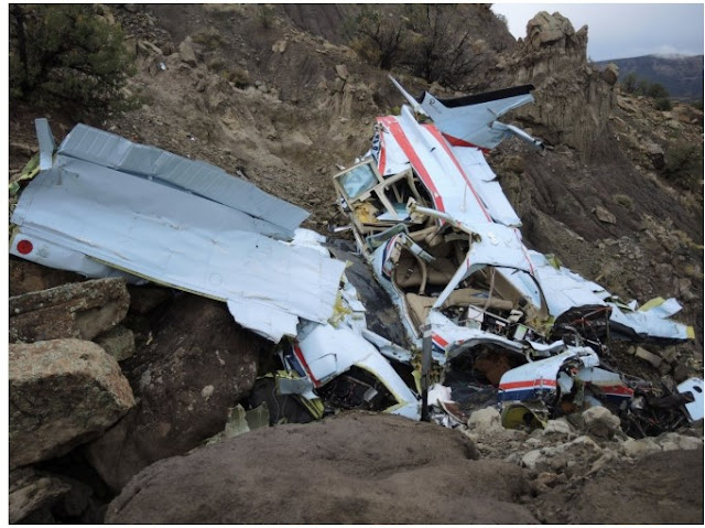
Examination of the accident scene revealed a debris path that was about 150 ft long and oriented on a heading of about 188° magnetic. It began with damaged treetops and broken limbs, where the tail rotor assembly and fragments of the tail rotor guard were located. The main impact crater, which contained fragmented landing gear components was about 60 ft from the initial tree strike, with the main wreckage located about 60 ft beyond the impact crater. The fuselage was fragmented and compressed from the nose toward the rear seats. All flight control attachment fittings remained attached at their ends. The push-pull tubes between the servos and the swashplate remained intact. All other flight control push-pull tubes were fractured, some in multiple locations, consistent with overload. The sprag clutch operated normally and smoothly when rotated by hand. All four main drive belts were intact and found in place around both drive sheaves. The upper drive sheave had impact marks on the front and rear faces adjacent to the clutch centering strut and fuselage frame tubes, respectively. A 3-inch imprint consistent with the starter ring gear was present in the grooves of the upper sheave. The main and auxiliary fuel tanks were impact damaged; their bladders were breached, and a trace amount of fuel remained in the bladders. Some vegetation surrounding the impact crater and the main wreckage showed evidence of fuel blight. The engine crankshaft rotated smoothly when turned by hand at the cooling fan. Crankshaft and valvetrain continuity were confirmed as the crankshaft was rotated. The accessory case cover was fractured with some portions missing, exposing the accessory gears. Thumb suction and compression was attained on all 6 cylinders. A borescope examination of all cylinders revealed no internal damage or anomalies. Both magnetos were found separated from the engine. The left magneto was fractured in half and with the lower half not recovered. The right magneto has some impact damage to the top near the condenser but was otherwise intact. It would not produce spark on any leads when tested. The fuel servo was separated from the engine and partially fragmented. The butterfly valve was open about 75% and could not be moved by hand. The inlet screen was absent of debris and liquid with an odor consistent with aviation fuel drained out of the servo when the screen was removed. The servo regulator section was partially disassembled and no damage to the internal rubber diaphragms or other components noted. The air filter box was separated from the engine, the filter element was clean and unobstructed.

The 1345 weather conditions reported at New York Stewart International Airport (SWF), located about 7 miles northwest of the accident site at an elevation of 491 ft msl, included an overcast cloud ceiling at 1,500 ft, visibility 5 miles in mist. At the time of the accident a National Weather Service airman’s meteorological information advisory was in effect for the accident area and the intended destination, warning of possible instrument flight rules weather conditions.

The helicopter was retained for further examination. 

Aircraft and Owner/Operator Information

Aircraft Make: ROBINSON HELICOPTER COMPANY
Registration: N637HP
Model/Series: R44 II 
Aircraft Category: Helicopter
Amateur Built:
Operator: 
Operating Certificate(s) Held: None
Operator Designator Code:

Meteorological Information and Flight Plan

Conditions at Accident Site: VMC
Condition of Light: Day
Observation Facility, Elevation: SWF,491 ft msl
Observation Time: 13:45 Local
Distance from Accident Site: 7 Nautical Miles
Temperature/Dew Point: 16°C /14°C
Lowest Cloud Condition: 
Wind Speed/Gusts, Direction: 5 knots / , 70°
Lowest Ceiling: Overcast / 1500 ft AGL
Visibility: 5 miles
Altimeter Setting: 30.2 inches Hg
Type of Flight Plan Filed: None
Departure Point: Glenn Falls, NY (GFL) 
Destination: Ronkonkoma, NY (ISP)

Wreckage and Impact Information

Crew Injuries: 1 Fatal
Aircraft Damage: Destroyed
Passenger Injuries: 
Aircraft Fire: None
Ground Injuries: N/A 
Aircraft Explosion: None
Total Injuries: 1 Fatal
Latitude, Longitude: 41.427329,-73.98554 

Those who may have information that might be relevant to the National Transportation Safety Board (NTSB) investigation may contact them by email witness@ntsb.gov, and any friends and family who want to contact investigators about the accident should email assistance@ntsb.gov. You can also call the NTSB Response Operations Center at 844-373-9922 or 202-314-6290. 


CORNWALL – The pilot of a helicopter that crashed near Storm King Mountain in the Town of Cornwall has been identified as a Setauket, NY resident.

State Police said on Monday that Arthur Charych, 73, was pronounced dead at scene. There were no passengers on board.

The helicopter he was operating was a Robinson R44 Raven II.

The crash occurred around 2:30 p.m. on Sunday.

Beech 58 Baron, N9955M: Incident occurred October 09, 2021 at Akron-Canton Regional Airport (KCAK), Summit County, Ohio

Federal Aviation Administration / Flight Standards District Office; Cleveland, Ohio

Aircraft blew a tire on landing and went off the runway.  


Date: 09-OCT-21
Time: 17:17:00Z
Regis#: N9955M
Aircraft Make: BEECH
Aircraft Model: 58
Event Type: INCIDENT
Highest Injury: NONE
Aircraft Missing: No
Damage: MINOR
Activity: PERSONAL
Flight Phase: LANDING (LDG)
Operation: 91
City: AKRON
State: OHIO

Flight Design CTLS, N121YT: Accident occurred October 10, 2021 near Greenville Downtown Airport (KGMU), Greenville County, South Carolina

This is preliminary information, subject to change, and may contain errors. Any errors in this report will be corrected when the final report has been completed.

The National Transportation Safety Board did not travel to the scene of this accident.

Additional Participating Entity:
Federal Aviation Administration / Flight Standards District Office; Columbia, South Carolina


Location: Greenville, South Carolina
Accident Number: ERA22LA011
Date and Time: October 10, 2021, 12:10 Local 
Registration: N121YT
Aircraft: FLIGHT DESIGN GMBH CTLS 
Injuries: 1 Minor
Flight Conducted Under: Part 91: General aviation - Personal

On October 10, 2021, about 1210 eastern daylight time, a Flight Design GMBH CTLS, N121YT, was substantially damaged when it was involved in an accident near, Greenville, South Carolina. The pilot received minor injuries. The airplane was operated as a Title 14 Code of Federal Regulations Part 91 personal flight.

According to the pilot, an annual inspection was conducted at Twin Lakes Airport (S17), Graniteville, South Carolina and the accident flight was his first flight in the airplane after the inspection. He conducted a preflight inspection of the airplane with no anomalies noted and departed for Henderson, North Carolina. About 18 miles south of his destination, the engine oil pressure dropped to zero. The pilot turned towards Greenville Downtown Airport (GMU), Greenville, South Carolina, and declared an emergency. The engine continued to run for about 4 or 5 minutes before it seized. The pilot reported to GMU that he would not be able to reach the airport and turned towards an open clearing before deploying the airplane’s ballistic parachute about 500 ft above ground level (agl). Shortly after deploying the parachute, the airplane floated into pine trees and was suspended about 50 ft agl about 9 miles north of GMU. The pilot climbed out of the side window and was rescued by local authorities.

Postaccident examination of the airplane by a Federal Aviation Administration inspector revealed two engine oil hoses disconnected and substantial damage to the fuselage and left wing.

The airplane was recovered for further examination.

Aircraft and Owner/Operator Information

Aircraft Make: FLIGHT DESIGN GMBH
Registration: N121YT
Model/Series: CTLS 
Aircraft Category: Airplane
Amateur Built:
Operator: On file
Operating Certificate(s) Held: None
Operator Designator Code:

Meteorological Information and Flight Plan

Conditions at Accident Site: VMC
Condition of Light: Day
Observation Facility, Elevation: GMU,1048 ft msl 
Observation Time: 12:53 Local
Distance from Accident Site: 3 Nautical Miles
Temperature/Dew Point: 25°C /16°C
Lowest Cloud Condition: Clear 
Wind Speed/Gusts, Direction: 6 knots / , 20°
Lowest Ceiling: None 
Visibility: 10 miles
Altimeter Setting: 30.05 inches Hg 
Type of Flight Plan Filed: None
Departure Point: Graniteville, SC (S17)
Destination: Henderson, NC (0A7)

Wreckage and Impact Information

Crew Injuries: 1 Minor 
Aircraft Damage: Substantial
Passenger Injuries: N/A 
Aircraft Fire: None
Ground Injuries: N/A 
Aircraft Explosion: None
Total Injuries: 1 Minor 
Latitude, Longitude: 34.886696,-82.359983 (est)


GREENVILLE, South Carolina  —  A plane has crashed in Greenville County Sunday afternoon near a populated area, according to dispatchers.

Dispatchers said the first calls came in just after noon about a plane going down behind a home on Highview Drive. That's across from Wade Hampton High School in the area of Woodlawn Cemetery, off Wade Hampton Boulevard.

Dispatchers said crews from the Wade Hampton Fire Department were at the scene.

Emails to the newsroom said both county and city law enforcement were also at the scene.

"The officer up at the intersection said a plane had crashed and then he pointed to it and that's when we first saw the plane up in the tree," said Michael Rubner, a nearby neighbor.

A WYFF News 4 crew at the scene talked to the pilot, William Kepper, who said he was flying from Aiken when the plane had an engine failure and the parachute saved his life.

He said he called the Downtown Greenville Airport and declared an emergency, and was cleared to land there, but he knew he wouldn't make it.

He was forced to deploy the craft's parachute to slow it down before impact.

He guided the plane into some trees behind a house and was able to climb out of the wreckage with just some scratches.

He said he does not need hospital treatment.

It was a surprise to neighbors.

"What I asked him was if he was actually trying to hit the tree and the gentleman said, 'No, as soon as you open the parachute, you just don't know where you're gonna land,' but just for the grace of God he actually landed on that tree. That's unbelievable," said Melcom Sanchez, another neighbor.


Zuber Super Drifter, N70TZ: Accident occurred October 08, 2021 in Horseshoe Bay, Texas


This is preliminary information, subject to change, and may contain errors. Any errors in this report will be corrected when the final report has been completed. 

The National Transportation Safety Board did not travel to the scene of this accident.

Additional Participating Entity: 
Federal Aviation Administration / Flight Standards District Office; San Antonio, Texas

Investigation Docket - National Transportation Safety Board: 

Location: Horseshoe Bay, TX
Accident Number: CEN22LA015
Date & Time: October 8, 2021, 19:11 Local 
Registration: N70TZ
Aircraft: ZUBER THOMAS P ZUBER SUPER
DRIFTER Injuries: 1 None
Flight Conducted Under: Part 91: General aviation - Personal

Aircraft and Owner/Operator Information

Aircraft Make: ZUBER THOMAS P 
Registration: N70TZ
Model/Series: ZUBER SUPER DRIFTER 
Aircraft Category: Airplane
Amateur Built:
Operator: On file 
Operating Certificate(s) Held: None
Operator Designator Code:

Meteorological Information and Flight Plan

Conditions at Accident Site:
Condition of Light:
Observation Facility, Elevation: 
Observation Time:
Distance from Accident Site: 
Temperature/Dew Point:
Lowest Cloud Condition: 
Wind Speed/Gusts, Direction: / ,
Lowest Ceiling:
Visibility:
Altimeter Setting:
Type of Flight Plan Filed:
Departure Point:
Destination:

Wreckage and Impact Information

Crew Injuries: 1 None
Aircraft Damage: Substantial
Passenger Injuries: 
Aircraft Fire: None
Ground Injuries: 
Aircraft Explosion: None
Total Injuries: 1 None
Latitude, Longitude: 30.566582,-98.394558 (est)

Mooney M20, N5227B: Incident occurred October 11, 2021 at Kerrville Municipal Airport (KERV), Kerr County, Texas

Federal Aviation Administration / Flight Standards District Office; San Antonio, Texas

Aircraft nose gear collapsed on landing Runway 12. 

Niner Five Whiskey LLC


Date: 11-OCT-21
Time: 17:45:00Z
Regis#: N5227B
Aircraft Make: MOONEY
Aircraft Model: M20
Event Type: INCIDENT
Highest Injury: NONE
Aircraft Missing: No
Damage: MINOR
Activity: PERSONAL
Flight Phase: LANDING (LDG)
Operation: 91
City: KERRVILLE
State: TEXAS

Cessna R182 Skylane RG, N739UZ: Incident occurred October 11, 2021 at Devine Municipal Airport (23R), Medina County, Texas

Federal Aviation Administration / Flight Standards District Office; San Antonio, Texas

Aircraft landed gear up for unknown reasons. 

Cameron Aviation LLC


Date: 11-OCT-21
Time: 22:00:00Z
Regis#: N739UZ
Aircraft Make: CESSNA
Aircraft Model: 182R
Event Type: INCIDENT
Highest Injury: NONE
Aircraft Missing: No
Damage: MINOR
Activity: PERSONAL
Flight Phase: LANDING (LDG)
Operation: 91
City: DEVINE
State: TEXAS

Luscombe 8, N4581M: Accident occurred October 09, 2021 at Winchester Regional Airport (KOKV), Frederick County, Virginia


This is preliminary information, subject to change, and may contain errors. Any errors in this report will be corrected when the final report has been completed.

The National Transportation Safety Board did not travel to the scene of this accident. 

Additional Participating Entity: 
Federal Aviation Administration / Flight Standards District Office; Herndon, Virginia

Investigation Docket - National Transportation Safety Board: 


Location: Winchester, Virginia
Accident Number: ERA22LA012
Date and Time: October 9, 2021, 14:22 Local 
Registration: N4581M
Aircraft: Luscombe 8A 
Injuries: 2 None
Flight Conducted Under: Part 91: General aviation - Personal

Aircraft and Owner/Operator Information

Aircraft Make: Luscombe 
Registration: N4581M
Model/Series: 8A 
Aircraft Category: Airplane
Amateur Built:
Operator: 
Operating Certificate(s) Held: None
Operator Designator Code:

Meteorological Information and Flight Plan

Conditions at Accident Site: VMC
Condition of Light: Day
Observation Facility, Elevation: KOKV,727 ft msl
Observation Time: 14:15 Local
Distance from Accident Site: 0 Nautical Miles
Temperature/Dew Point: 18°C /15°C
Lowest Cloud Condition: 
Wind Speed/Gusts, Direction: 4 knots / , 100°
Lowest Ceiling: Overcast / 4200 ft AGL 
Visibility: 10 miles
Altimeter Setting: 30.12 inches Hg 
Type of Flight Plan Filed: None
Departure Point: Winchester, VA
Destination: Winchester, VA

Wreckage and Impact Information

Crew Injuries: 1 None 
Aircraft Damage: Substantial
Passenger Injuries: 1 None 
Aircraft Fire: None
Ground Injuries: 
Aircraft Explosion: None
Total Injuries: 2 None
Latitude, Longitude: 39.143528,-78.144444 (est)


WINCHESTER — No injuries occurred when a single-engine plane flipped while landing at Winchester Regional Airport Saturday, airport Executive Director Nick Sabo said.

Upon landing around 1 p.m., Sabo explained the pilot of a Luscombe 8 hit “the brakes a little too hard” while traveling on the runway at an estimated 30 miles per hour. Brakes on the front two wheels locked up, which Sabo said caused the “nose heavy” plane to tip forward. The propeller then hit the ground and momentum caused the plane to flip over.

Sabo said airport staff responded immediately and called off en-route emergency vehicles when the pilot and one passenger declined medical services. The Federal Aviation Administration was notified and did not send an investigator for such a minor incident.

Sabo said the airport was closed for about an hour while the plane was forklifted onto a flatbed trailer. He said the plane “was banged up pretty good,” but the aircraft was fully intact and likely repairable.

Beechcraft 58TC Baron, N6748V: Fatal accident occurred October 11, 2021 in Mesa, Colorado

This is preliminary information, subject to change, and may contain errors. Any errors in this report will be corrected when the final report has been completed.

The National Transportation Safety Board traveled to the scene of this accident.

Additional Participating Entities:
Federal Aviation Administration / Flight Standards District Office; Salt Lake City, Utah
Textron Aviation; Wichita, Kansas 

Cannon Oil & Gas Well Services Inc


Location: Mesa, Colorado
Accident Number: CEN22FA011
Date and Time: October 11, 2021, 08:57 Local
Registration: N6748V
Aircraft: Beech 58TC Injuries: 1 Fatal
Flight Conducted Under: Part 91: General aviation - Personal

On October 11, 2021, at 0857 mountain daylight time, a Beech 58TC airplane, N6748V, was destroyed when it was involved in an accident near Mesa, Colorado. The pilot was fatally injured. The airplane was operated as a Title 14 Code of Federal Regulations Part 91 personal flight.

Fixed Base Operator (FBO) employees at Blake Field Airport (AJZ), Delta, Colorado, stated that before departure the pilot fueled the airplane with 100 gallons of aviation gasoline. The airplane taxied away from the fuel pump at 0839 and proceeded to runway 03. The airplane departed about 0843 and proceeded northeast toward its destination, Southwest Wyoming Regional Airport (RKS), Rock Springs, Wyoming. They also stated that this was the airplane’s first flight after an annual inspection had been completed on October 1, 2021.

Automatic Dependent Surveillance-Broadcast (ADS-B) data revealed that about 0846 the airplane departed from runway 03 and proceeded northeast for about 4 nautical miles (nm), then turned left to north-northwest and climbed over Grand Mesa. After crossing over Grand Mesa, the airplane reached about 14,000 ft mean sea level (msl). At 0855:51 the airplane turned right and descended about 1,000 ft, then climbed to 15,000 ft. At 0856:26 the airplane descended rapidly toward terrain. 

A summary of air traffic control (ATC) communications revealed that pilot was in contact with ATC and at 0852 he reported climbing through 11,000 ft for 14,000 ft. At 0857:00 the controller asked the pilot, “did you get an updraft, mountain wave out there? I’m showing you 800 ft high.” There were no other communications from the pilot. 

A review of the meteorological information revealed the potential for light to moderate turbulence and mountain wave activity near the accident site. National Weather Service had no active AIRMET, SIGMET, Convective SIGMET, or Center Weather Advisory, for the route of flight.

The airplane impacted a rocky mountainside and remained upright on a heading of about 040°. The wreckage debris path was about 30 ft long and mostly consisted of paint chips, shards of windscreen, various small debris and a large outboard section of the right wing that had separated on impact. The empennage was distorted to the left and remained partially attached to the rear fuselage. The bottom of the airplane exhibited impact damage and scoring from the rocky terrain. The left engine was mostly separated from the left wing nacelle, while the right engine remained attached to the right wing nacelle. The six propeller blades were relatively undamaged and did not exhibit leading edge damage or scoring. 

The airplane has been retained for further examination.


Aircraft and Owner/Operator Information

Aircraft Make: Beech 
Registration: N6748V
Model/Series: 58TC
Aircraft Category: Airplane
Amateur Built:
Operator: On file 
Operating Certificate(s) Held: None
Operator Designator Code:

Meteorological Information and Flight Plan

Conditions at Accident Site: VMC
Condition of Light: Day
Observation Facility, Elevation: KGJT,4839 ft msl 
Observation Time: 08:53 Local
Distance from Accident Site: 20 Nautical Miles
Temperature/Dew Point: 8°C /1°C
Lowest Cloud Condition: Clear
Wind Speed/Gusts, Direction: 15 knots / , 100°
Lowest Ceiling: None 
Visibility: 10 miles
Altimeter Setting: 29.83 inches Hg
Type of Flight Plan Filed: IFR
Departure Point: Delta, CO (AJZ) 
Destination: Rock Springs, WY (RKS)

Wreckage and Impact Information

Crew Injuries: 1 Fatal
Aircraft Damage: Destroyed
Passenger Injuries: 
Aircraft Fire: None
Ground Injuries: N/A
Aircraft Explosion: None
Total Injuries: 1 Fatal 
Latitude, Longitude: 39.206496,-108.12369 

Those who may have information that might be relevant to the National Transportation Safety Board (NTSB) investigation may contact them by email witness@ntsb.gov, and any friends and family who want to contact investigators about the accident should email assistance@ntsb.gov. You can also call the NTSB Response Operations Center at 844-373-9922 or 202-314-6290.

Robert Dale Cannon 
(October 2, 1953 – October 11, 2021)


Robert “Rob” Dale Cannon was born October 2, 1953 to Edward and Eileen Cannon. Rob was raised in Kimball, Nebraska and is still known for his athletic achievements.

Rob moved to Wyoming in the mid 1970s and started what would become the very successful Cannon Oil & Gas Well Service, Inc., which still operates today. Rob met his perfect match and love of his life, Elaine, in 1977 and they married on December 23, 1978.

Rob and Elaine lived in Green River, WY where they raised their four children, Heather, Andrea, Alesha, and Edward (Bubba). Rob and Elaine have been blessed with 10 grandchildren.

Rob also founded and operated Rocky Mountain Testers as well as Cedar Rentals and Cannon Farms, which also continue to operate. Rob and Elaine recently built Cannon Xpress Carwash with their son, Bubba, and Rob was excited about the future of this new endeavor.

Rob was very passionate about conservation and dug many ponds and easily planted upwards of 100,000 trees over the years. Rob was an avid golfer and hunter, which he enjoyed and shared with not only family and friends but also with veterans who he always felt so honored and humbled to support and serve.

Rob earned his pilot’s license in 1975 and was a skilled and highly trained pilot, he had a true passion for flying. Rob truly believed in God, family, country and always focused on the needs of others. He was a true patriarch in every sense. Rob had an unshakable faith in Jesus Christ and impacted countless lives with his gravitating personality.

While Rob was taken too soon his legacy will continue to live on through the numerous people who cherish him.

Rob is survived by his beloved wife, Elaine; his children Heather (Jason), Andrea (Joey), Alesha (Ryan), and Bubba (Jordan); his mother, Eileen; his grandchildren Cannon, Olsen, Hudson, Easton, Truman, Rowan, Ben, Aiden, Robbie, Ryker and Harlowe. Rob also leaves behind several extended family members and many close friends he loved as family.

Rob was incredibly generous to many and would only wish to carry this forward so in lieu of flowers, please consider donating to boystown.org or littlesistersofthepoor.org in his memory.

A rosary will be held on Friday evening and a funeral mass on Saturday, October 23 at 10:00 am at St. Elizabeth’s Catholic Church in Oshkosh, NE.


The Mesa County Coroner’s Office has identified the pilot and sole occupant of a plane that crashed northeast of Mesa on Monday morning.

Robert Cannon, 68, of Rock Springs, Wyoming, was killed in the crash, according to a Coroner’s Office press release.

According to the release, Cannon died of multiple blunt force injuries and his death was an accident.

Cannon was flying from Delta’s Blake Field airport to Rock Springs when his plane lost contact with the Denver Air Center and went down, according to the Mesa County Sheriff’s Office.

The crash was discovered by a search helicopter just northwest of Mesa on Monday, and the body was removed from the scene Monday afternoon.

The National Transportation Safety Board is investigating the crash.


The pilot and sole occupant of a Beechcraft 58TC Baron plane that crashed northeast of Mesa on Monday is dead, the Mesa County Sheriff’s Office confirmed.

Monday morning, the Sheriff’s Office was notified by the Denver Air Center that the center had lost contact and radar with a plane that was supposed to fly from Delta’s Blake Field airport to Rock Springs, Wyoming, in the area of Castle Peak southeast of De Beque.

Additionally, the Plateau Valley Fire District received calls Monday morning about an airplane that may have been going down.

CareFlight and Civil Air Patrol both mobilized. A search helicopter located the wreckage of the airplane on a hillside near Jerry Creek Reservoirs, northeast of Mesa.

The reservoirs, which are owned by the Ute Water District, were unaffected by the crash, Mesa County Sheriff’s Office Public Information Officer Megan Terlecky said.

The crash site is in a remote area, Phil Stratton of the Mesa County Sheriff’s Office said, so two deputies were airlifted by helicopter to secure the scene, and a Colorado State Patrol trooper followed with Mesa County Coroner Victor Yahn.

The pilot’s body was removed from the scene by helicopter Monday afternoon and is pending identification by the Coroner’s Office after the family has been notified.

The National Transportation Safety Board is investigating the incident. Mesa County Search and Rescue also assisted with the incident.