Friday, September 17, 2021

Robinson R44 II, Incident occurred September 16, 2021 in Lihue, Hawaii

Federal Aviation Administration / Flight Standards District Office; Honolulu, Hawaii

Rotorcraft struck a bird leaving a hole in the right windshield.  

Hawaii Pacific Aviation Inc


Date: 16-SEP-21
Time: 19:30:00Z
Regis#: N120AB
Aircraft Make: ROBINSON
Aircraft Model: R44
Event Type: INCIDENT
Highest Injury: NONE
Aircraft Missing: No
Damage: UNKNOWN
Activity: SIGHT SEEING
Flight Phase: EN ROUTE (ENR)
Operation: 91
City: LIHUE
State: HAWAII

CZAW SportCruiser, N218JD: Incident occurred September 16, 2021 at Shelby County Airport (2H0), Illinois

Federal Aviation Administration / Flight Standards District Office; Springfield, Illinois

Aircraft crashed into field on departure. 

Gabel Sport Aviation LLC


Date: 16-SEP-21
Time: 13:30:00Z
Regis#: N218JD
Aircraft Make: CZECH SPORT
Aircraft Model: SPORTCRUISER
Event Type: INCIDENT
Highest Injury: NONE
Aircraft Missing: No
Damage: MINOR
Activity: INSTRUCTION
Flight Phase: TAKEOFF (TOF)
Operation: 91
City: SHELBYVILLE
State: ILLINOIS

Mooney M20J 201, N823SP: Accident occurred September 16, 2021 in Howell, Livingston County, Michigan

This is preliminary information, subject to change, and may contain errors. Any errors in this report will be corrected when the final report has been completed. 

The National Transportation Safety Board did not travel to the scene of this accident. 

Additional Participating Entity:
Federal Aviation Administration / Flight Standards District Office; East Michigan

S & P Services Inc 


Location: Howell, Michigan
Accident Number: CEN21LA423
Date and Time: September 16, 2021, 15:45 Local 
Registration: N823SP
Aircraft: Mooney M20J 
Injuries: 1 None
Flight Conducted Under: Part 91: General aviation - Personal

Aircraft and Owner/Operator Information

Aircraft Make: Mooney
Registration: N823SP
Model/Series: M20J
Aircraft Category: Airplane
Amateur Built:
Operator:
Operating Certificate(s) Held: None
Operator Designator Code:

Meteorological Information and Flight Plan

Conditions at Accident Site: 
Condition of Light:
Observation Facility, Elevation: 
Observation Time:
Distance from Accident Site:
Temperature/Dew Point:
Lowest Cloud Condition: 
Wind Speed/Gusts, Direction: / ,
Lowest Ceiling: 
Visibility:
Altimeter Setting: 
Type of Flight Plan Filed:
Departure Point: 
Destination:

Wreckage and Impact Information

Crew Injuries: 1 None 
Aircraft Damage: Substantial
Passenger Injuries: N/A 
Aircraft Fire: None
Ground Injuries:
Aircraft Explosion: None
Total Injuries: 1 None
Latitude, Longitude: 42.6073,83.9294 (est)

Loss of Control on Ground: Waco 2T-1A-2, N53GL; accident occurred September 16, 2021 at Battle Creek Executive Airport (KBTL), Calhoun County, Michigan


Aviation Accident Final Report - National Transportation Safety Board

The National Transportation Safety Board did not travel to the scene of this accident.

Additional Participating Entity:
Federal Aviation Administration / Flight Standards District Office; Grand Rapids, Michigan

Investigation Docket - National Transportation Safety Board:

PF Flyers Inc


Location: Battle Creek, Michigan
Accident Number: CEN21LA430
Date and Time: September 16, 2021, 15:56 Local
Registration: N53GL
Aircraft: WACO CLASSIC AIRCRAFT CORP 2T1A-2 
Aircraft Damage: Substantial
Defining Event: Loss of control on ground 
Injuries: 2 None
Flight Conducted Under: Part 91: General aviation - Instructional

Analysis

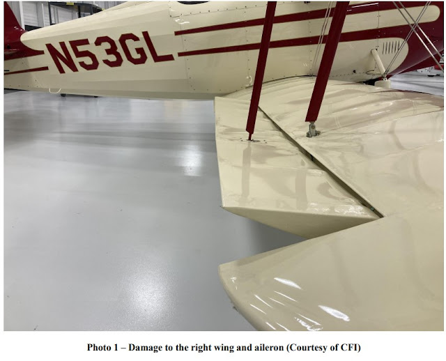
The pilot was receiving additional flight instruction in the tailwheel-equipped airplane. During the landing with a crosswind, the airplane bounced and then settled onto the runway. The airplane veered to the right, so the pilot applied left rudder but overcorrected to the left. The pilot then relinquished the controls to the flight instructor. The flight instructor was unable to regain control and the airplane ground looped. The airplane sustained substantial damage to the lower right wing rear spar and aileron. The pilot and flight instructor both reported that there were no mechanical malfunctions or anomalies with the airplane that would have precluded normal operation.

Probable Cause and Findings

The National Transportation Safety Board determines the probable cause(s) of this accident to be:
The pilot’s failure to maintain directional control of the tailwheel equipped airplane during a crosswind landing and the flight instructor’s inadequate remedial action. 

Findings

Personnel issues Aircraft control - Pilot
Personnel issues Aircraft control - Instructor/check pilot
Aircraft Directional control - Not attained/maintained
Environmental issues Crosswind - Effect on operation

Factual Information

History of Flight

Landing-landing roll Loss of control on ground (Defining event)
Landing-landing roll Attempted remediation/recovery

Pilot Information

Certificate: Commercial 
Age: 40, Male
Airplane Rating(s): Single-engine land 
Seat Occupied: Rear
Other Aircraft Rating(s): None
Restraint Used: 4-point
Instrument Rating(s): Airplane 
Second Pilot Present: Yes
Instructor Rating(s): None 
Toxicology Performed:
Medical Certification: Class 1 Without waivers/limitations
Last FAA Medical Exam: May 26, 2021
Occupational Pilot: No 
Last Flight Review or Equivalent: October 31, 2020
Flight Time: 490.6 hours (Total, all aircraft), 12.2 hours (Total, this make and model), 408.5 hours (Pilot In Command, all aircraft), 65.7 hours (Last 90 days, all aircraft), 15 hours (Last 30 days, all aircraft)

Flight instructor Information

Certificate: Commercial; Flight instructor 
Age: Male
Airplane Rating(s): Single-engine land; Single-engine sea; Multi-engine land
Seat Occupied: Front
Other Aircraft Rating(s): None 
Restraint Used: 4-point
Instrument Rating(s): Airplane 
Second Pilot Present: Yes
Instructor Rating(s): Airplane multi-engine; Airplane single-engine; Instrument airplane
Toxicology Performed:
Medical Certification: Class 1 Without waivers/limitations
Last FAA Medical Exam: June 15, 2021
Occupational Pilot: Yes 
Last Flight Review or Equivalent: August 7, 2020
Flight Time: 1952 hours (Total, all aircraft), 181 hours (Total, this make and model), 1866 hours (Pilot In Command, all aircraft), 114 hours (Last 90 days, all aircraft), 57 hours (Last 30 days, all aircraft), 3 hours (Last 24 hours, all aircraft)

Aircraft and Owner/Operator Information

Aircraft Make: WACO CLASSIC AIRCRAFT CORP
Registration: N53GL
Model/Series: 2T-1A-2 
Aircraft Category: Airplane
Year of Manufacture: 2015 
Amateur Built:
Airworthiness Certificate: Aerobatic; Normal
Serial Number: 1206
Landing Gear Type: Tailwheel
Seats: 2
Date/Type of Last Inspection: July 14, 2021 
Annual Certified Max Gross Wt.: 1800 lbs
Time Since Last Inspection: 10.5 Hrs
Engines: 1 Reciprocating
Airframe Total Time: 161.2 Hrs at time of accident
Engine Manufacturer: Lycoming
ELT: C126 installed, not activated 
Engine Model/Series: AEIO-360-B1G6
Registered Owner: 
Rated Power: 180 Horsepower
Operator: On file
Operating Certificate(s) Held: None

Meteorological Information and Flight Plan

Conditions at Accident Site: Visual (VMC) 
Condition of Light: Day
Observation Facility, Elevation: KBTL,939 ft msl
Distance from Accident Site: 0 Nautical Miles
Observation Time: 15:53 Local
Direction from Accident Site: 33°
Lowest Cloud Condition: Clear
Visibility: 10 miles
Lowest Ceiling: None
Visibility (RVR):
Wind Speed/Gusts: 4 knots / 
Turbulence Type Forecast/Actual: /
Wind Direction: 200° 
Turbulence Severity Forecast/Actual:  /
Altimeter Setting: 30.11 inches Hg
Temperature/Dew Point: 26°C / 11°C
Precipitation and Obscuration: No Obscuration; No Precipitation
Departure Point: Battle Creek, MI
Type of Flight Plan Filed: None
Destination: Battle Creek, MI 
Type of Clearance: VFR
Departure Time: 
Type of Airspace: Class D

Airport Information

Airport: BATTLE CREEK EXEC AT KELLOGG FLD BTL
Runway Surface Type: Asphalt
Airport Elevation: 951 ft msl
Runway Surface Condition: Dry
Runway Used: 05L/23R
IFR Approach: None
Runway Length/Width: 10004 ft / 150 ft 
VFR Approach/Landing: Touch and go; Traffic pattern

Wreckage and Impact Information

Crew Injuries: 2 None 
Aircraft Damage: Substantial
Passenger Injuries:
Aircraft Fire: None
Ground Injuries: N/A 
Aircraft Explosion: None
Total Injuries: 2 None
Latitude, Longitude: 42.307638,-85.251317 (est)

Loss of Control on Ground: Cessna 195, N4358V; accident occurred September 16, 2021 at Willow Run Airport (KYIP), Ypsilanti, Washtenaw County, Michigan


Aviation Accident Final Report - National Transportation Safety Board 

The National Transportation Safety Board did not travel to the scene of this accident.

Additional Participating Entity:
Federal Aviation Administration / Flight Standards District Office; Belleville, Michigan

Investigation Docket - National Transportation Safety Board:
Location: Ypsilanti, Michigan
Accident Number: CEN21LA422
Date and Time: September 16, 2021, 12:20 Local
Registration: N4358V
Aircraft: Cessna 195
Aircraft Damage: Substantial
Defining Event: Loss of control on ground
Injuries: 1 None
Flight Conducted Under: Part 91: General aviation - Personal

Analysis

The commercial pilot reported that after landing in the tailwheel-equipped airplane, he performed a “higher than normal speed taxi” to exit the runway to make way for incoming landing traffic. During the taxi, he lost directional control, which resulted in a ground loop. During the ground loop, the right wing and the right horizontal stabilizer impacted the ground, sustaining substantial damage to both areas. The airplane came to rest upright, and the pilot taxied back to his hangar.

The pilot reported there were no preimpact mechanical malfunctions or failures with the airframe and engine that would have precluded normal operation. The pilot additionally reported that he should have “taken the time necessary” to taxi the airplane safely off the runway and that he should not have “concerned myself with the fact that there was incoming traffic behind me.”

Probable Cause and Findings

The National Transportation Safety Board determines the probable cause(s) of this accident to be:
The pilot’s failure to maintain directional control during taxi, which resulted in a ground loop.

Findings

Personnel issues Aircraft control - Pilot
Aircraft Directional control - Not attained/maintained

Factual Information

History of Flight

Taxi-from runway Loss of control on ground (Defining event)
Taxi-from runway Collision with terr/obj (non-CFIT)

Pilot Information

Certificate: Commercial 
Age: 66, Male
Airplane Rating(s): Single-engine land; Single-engine sea
Seat Occupied: Left
Other Aircraft Rating(s): None 
Restraint Used: 4-point
Instrument Rating(s): Airplane 
Second Pilot Present: No
Instructor Rating(s): None
Toxicology Performed:
Medical Certification: Class 2 With waivers/limitations 
Last FAA Medical Exam: November 20, 2020
Occupational Pilot: No
Last Flight Review or Equivalent: July 4, 2021
Flight Time: 832 hours (Total, all aircraft), 100 hours (Total, this make and model), 684 hours (Pilot In Command, all aircraft), 12 hours (Last 90 days, all aircraft), 6 hours (Last 30 days, all aircraft), 1 hours (Last 24 hours, all aircraft)

Aircraft and Owner/Operator Information

Aircraft Make:
Cessna Registration: N4358V
Model/Series: 195 Aircraft Category: Airplane
Year of Manufacture: 1948 
Amateur Built:
Airworthiness Certificate:
Normal Serial Number: 7274
Landing Gear Type:
Tailwheel Seats: 5
Date/Type of Last Inspection: April 13, 2021 Annual
Certified Max Gross Wt.: 3350 lbs
Time Since Last Inspection:
Engines: 1 Reciprocating
Airframe Total Time: 4281.3 Hrs at time of accident
Engine Manufacturer: Jacobs Aircraft Engine Company
ELT: C91 installed, not activated 
Engine Model/Series: R-755B2
Registered Owner: 
Rated Power: 275 Horsepower
Operator: On file 
Operating Certificate(s) Held: None
Operator Does Business As: None 
Operator Designator Code: None

Meteorological Information and Flight Plan

Conditions at Accident Site: Visual (VMC)
Condition of Light: Day
Observation Facility, Elevation: KYIP,716 ft msl 
Distance from Accident Site: 0 Nautical Miles
Observation Time: 11:53 Local 
Direction from Accident Site: 143°
Lowest Cloud Condition: Clear 
Visibility: 10 miles
Lowest Ceiling: None
Visibility (RVR):
Wind Speed/Gusts: 7 knots / 
Turbulence Type Forecast/Actual: None / None
Wind Direction: 110° 
Turbulence Severity Forecast/Actual: N/A / N/A
Altimeter Setting: 30.19 inches Hg
Temperature/Dew Point: 26°C / 15°C
Precipitation and Obscuration: No Obscuration; No Precipitation
Departure Point: Ypsilanti, MI
Type of Flight Plan Filed: None
Destination: Ypsilanti, MI
Type of Clearance: None
Departure Time:
Type of Airspace: Class D

Airport Information

Airport: WILLOW RUN YIP 
Runway Surface Type: Concrete
Airport Elevation: 715 ft msl 
Runway Surface Condition: Dry
Runway Used: 05R/23L 
IFR Approach: None
Runway Length/Width: 7543 ft / 150 ft
VFR Approach/Landing: Full stop; Traffic pattern

Wreckage and Impact Information

Crew Injuries: 1 None
Aircraft Damage: Substantial
Passenger Injuries:
Aircraft Fire: None
Ground Injuries: 
Aircraft Explosion: None
Total Injuries: 1 None
Latitude, Longitude: 42.238195,-83.538268 (est)

Cessna 172: Incident occurred September 16, 2021 at Boulder City Municipal Airport (KBVU), Clark County, Nevada

Federal Aviation Administration / Flight Standards District Office; Las Vegas, Nevada

Aircraft struck airport sign during rollout.  

Date: 16-SEP-21
Time: 15:30:00Z
Aircraft Make: CESSNA
Aircraft Model: 172
Event Type: INCIDENT
Highest Injury: NONE
Aircraft Missing: No
Damage: MINOR
Activity: PERSONAL
Flight Phase: LANDING (LDG)
Operation: 91
City: BOULDER CITY
State: NEVADA

American Legend AL3, N948FS: Accident occurred September 14, 2021 at Aeroflex-Andover Airport (12N), Sussex County, New Jersey

This is preliminary information, subject to change, and may contain errors. Any errors in this report will be corrected when the final report has been completed.

The National Transportation Safety Board did not travel to the scene of this accident. 

Additional Participating Entity: 
Federal Aviation Administration / Flight Standards District Office; Allentown, Pennsylvania Location: Andover Township, New Jersey
Accident Number: ERA21LA375
Date and Time: September 14, 2021, 14:30 Local 
Registration: N948FS
Aircraft: AMERICAN LEGEND AIRCRAFT CO AL3
Injuries: 1 None
Flight Conducted Under: Part 91: General aviation - Personal

Aircraft and Owner/Operator Information

Aircraft Make: AMERICAN LEGEND AIRCRAFT CO
Registration: N948FS
Model/Series: AL3 
Aircraft Category: Airplane
Amateur Built:
Operator: On file 
Operating Certificate(s) Held: None
Operator Designator Code:

Meteorological Information and Flight Plan

Conditions at Accident Site: VMC
Condition of Light: Day
Observation Facility, Elevation: 12N,580 ft msl 
Observation Time: 14:54 Local
Distance from Accident Site: 0 Nautical Miles
Temperature/Dew Point: 27°C /21°C
Lowest Cloud Condition:
Wind Speed/Gusts, Direction: / ,
Lowest Ceiling:
Visibility:
Altimeter Setting: 30.04 inches Hg
Type of Flight Plan Filed: None
Departure Point: Andover Township, NJ
Destination: Andover Township, NJ

Wreckage and Impact Information

Crew Injuries: 1 None 
Aircraft Damage: Substantial
Passenger Injuries:
Aircraft Fire: None
Ground Injuries: N/A 
Aircraft Explosion: None
Total Injuries: 1 None 
Latitude, Longitude: 41.00862,-74.738034 (est)

Pilatus PC-12/45, N271SM: Incident occurred September 16, 2021 near Grand Forks International Airport (KGFK), Grand Forks County, North Dakota

Federal Aviation Administration / Flight Standards District Office; Fargo, North Dakota

Aircraft struck a bird damaging right wing.  

TVPX Aircraft Solutions Inc Trustee 


Date: 16-SEP-21
Time: 06:00:00Z
Regis#: N271SM
Aircraft Make: PILATUS
Aircraft Model: PC12
Event Type: INCIDENT
Highest Injury: NONE
Aircraft Missing: No
Damage: UNKNOWN
Activity: AMBULANCE
Flight Phase: APPROACH (APR)
Aircraft Operator: GUARDIAN FLIGHT
City: GRAND FORKS
State: NORTH DAKOTA

Jabiru Calypso 450, N2104: Incident occurred September 16, 2021 at Summerville Airport (KDYB), Dorchester County, South Carolina

Federal Aviation Administration / Flight Standards District Office; Columbia, South Carolina

Aircraft landed and veered off runway incurring a propeller strike. 


Date: 16-SEP-21
Time: 13:58:00Z
Regis#: N2104
Aircraft Make: JABIRU
Aircraft Model: CALYPSO 450
Event Type: INCIDENT
Highest Injury: NONE
Aircraft Missing: No
Damage: MINOR
Activity: PERSONAL
Flight Phase: LANDING (LDG)
Operation: 91
City: SUMMERVILLE
State: SOUTH CAROLINA

Piper PA-32-300 Cherokee Six, N33022: Accident occurred September 16, 2021 - Orcas Island, Washington

This is preliminary information, subject to change, and may contain errors. Any errors in this report will be corrected when the final report has been completed. 

The National Transportation Safety Board did not travel to the scene of this accident.

Additional Participating Entity: 
Federal Aviation Administration / Flight Standards District Office; Seattle, Washington Location: Orcas Island, Washington
Accident Number: WPR21LA363
Date and Time: September 16, 2021, 18:25 Local 
Registration: N33022
Aircraft: Piper PA-32-300
Injuries: 2 Serious, 1 Minor
Flight Conducted Under: Part 91: General aviation - Business

On September 16, 2021, at 1825 Pacific daylight time, a Piper PA-32-300, Cherokee Six, N33022, was substantially damaged when it was involved in an accident near Orcas Island, Washington. The pilot sustained minor injuries and the 2 passengers were seriously injured. The airplane was operated as a Title 14 Code of Federal Regulations Part 91 personal flight.

The flight originated from Bellingham International Airport (KBLI), Bellingham, Washington. The pilot reported that he planned to fly with the airplane owner over different business project sites on Orcas Island, and then stop at Friday Harbor Airport (KFHR), Friday Harbor, Washington, to meet a company employee and return him back to their operating base at KBLI.

While on climbout from Orcas Island, the pilot and the passenger observed an oily substance on the windscreen and decided to land immediately at KFHR. After landing, oil was found on the cowling and around the propeller hub.

Two mechanics hired by the owner to inspect the airplane following the precautionary landing reported that they did not find any oil on the upper engine cowling. They verified 10 quarts of oil in the engine, as reported by the pilot at the start of the flight. Oil residue was found at the front of the engine, near the crankshaft seal area. The area was cleaned, and the engine and propeller were respectively started and cycled with no oil leaks detected.

After the inspection the pilot departed KFHR with a planned destination of KBLI. During the climbout, the pilot observed the oil pressure in the yellow range and leveled off at 2,000 ft mean sea level. The pilot reduced engine power and set the propeller rpm between 2,200 to 2,300, and verified all engine parameters and readings were in the green. Shortly after, the engine “hesitated” and then lost all power.

The pilot maneuvered as he configured the airplane for best glide speed. During a turn, the pilot activated the auxiliary fuel pump, and switched the fuel selector from left to right main fuel tank. As the airplane continued its decent, the engine suddenly restarted, but again lost power. When the airplane was about 80 ft above the ground, the owner heard the stall warning horn. The airplane then landed hard on a grass field, bounced, and then came to rest upright.

The airplane and engine were recovered to a secure location for further examination.

Aircraft and Owner/Operator Information

Aircraft Make: Piper 
Registration: N33022
Model/Series: PA-32-300 
Aircraft Category: Airplane
Amateur Built:
Operator: 
Operating Certificate(s) Held: None
Operator Designator Code:

Meteorological Information and Flight Plan

Conditions at Accident Site:
Condition of Light:
Observation Facility, Elevation:
Observation Time:
Distance from Accident Site: 
Temperature/Dew Point:
Lowest Cloud Condition: 
Wind Speed/Gusts, Direction: / ,
Lowest Ceiling: 
Visibility:
Altimeter Setting: 
Type of Flight Plan Filed:
Departure Point: Friday Harbor, WA (KFHR) 
Destination: Bellingham, WA (KBLI)

Wreckage and Impact Information

Crew Injuries: 1 Minor 
Aircraft Damage: Substantial
Passenger Injuries: 2 Serious
Aircraft Fire: None
Ground Injuries: 
Aircraft Explosion: None
Total Injuries: 2 Serious, 1 Minor 
Latitude, Longitude: 48.646286,-122.78279 (est)

Robinson R66 Turbine, N888DV: Fatal accident occurred September 15, 2021 in Monticello, Jasper County, Georgia

This is preliminary information, subject to change, and may contain errors. Any errors in this report will be corrected when the final report has been completed. 

The National Transportation Safety Board traveled to the scene of this accident. 

Additional Participating Entities:
Federal Aviation Administration / Flight Standards District Office; Atlanta, Georgia
Rolls Royce; Indianapolis, Indiana 
Robinson Helicopters; California 

Monarch Helicopters Inc
Location: Monticello, Georgia
Accident Number: ERA21FA362
Date and Time: September 15, 2021, 22:00 Local 
Registration: N888DV
Aircraft: ROBINSON HELICOPTER CO R66 
Injuries: 3 Fatal
Flight Conducted Under: Part 135: Air taxi and commuter - Non-scheduled

On September 15, 2021, at 2046 eastern daylight time, a Robinson R66, N888DV, was destroyed when it was involved in an accident near Monticello, Georgia. The flight instructor, commercial pilot, and one passenger sustained fatal injuries. The passenger flight was operated under the provisions of Title 14 Code of Federal Regulations Part 135.

According to a company representative, the purpose of the chartered flight was to transport the passenger to southern Georgia and northern Florida for personal business. A family member of the passenger confirmed that the passenger had chartered the helicopter to “look at properties” in the area and was supposed to return later that evening. The trip originated at Fulton County Executive Airport/Charlie Brown Field (FTY) Atlanta, Georgia, about 0700 and proceeded south, making a stop in Reidsville, Georgia before continuing to Finlayson Farm Airport (9FL8) Greenville, Florida. The helicopter stopped there for several hours before beginning the return trip. No flight plan was filed for the flight.

During the return trip, they landed at Thomasville Regional Airport (TVI) Thomasville, Georgia, where the pilots requested fuel and the helicopter was topped off (76 gallons capacity) with 40 gallons of fuel. Preliminary Automatic Dependent Surveillance–Broadcast (ADS-B) data indicated the flight departed TVI at 1840, then proceeded on a northerly track for about 80 nautical miles near the town of Andersonville, Georgia. At 1937, the passenger’s family member sent a text message to him asking when he would be arriving. He responded with a photograph taken with his mobile device and stated “Approx [2130], bad storm pop up had to land in field. It’s blowing over now.” The photograph showed a grass field, gray skies, and rain on the helicopter window.

The ADS-B data showed that after departing the field to the west, the helicopter proceeded north and followed a power transmission line right-of-way for about 4 nm before reversing course and following the same right-of-way south for about 3 nm. The helicopter then turned left on a southeast track for about 15 nm before making a left turn to the north where they made an approach and brief landing at Perry-Houston County Airport (PXE), Perry, Georgia about 2015. 

After resuming the flight, the helicopter passed 4 nm west of Macon, Georgia, then passed about 2 nm east of a large powerplant before entering the Piedmont National Wildlife Refuge, a remote area covered with dense forest. About 2043, the helicopter made a series of shallow left and right track changes before entering a rapid descending right turn. The ADS-B signal was lost at 2046, with the helicopter at a reported altitude of 925 ft msl (or about 300 feet agl), and with the helicopter located about 400-ft laterally from the accident site. Witnesses south of the accident site reporting hearing a low flying helicopter about the time of the last observed ADS-B position and described that it was raining at that time.

At 2047, a base reflectivity National Weather Service weather radar image covering the area of the accident site, depicted echoes of 20 to 37 dBZ along the helicopter’s flight track, and in the vicinity of the accident site. Additionally, an isolated cell with maximum echo intensity of 53 dBZ was located about 4 nm west of the accident at that time. The echo was moving northward at a velocity of around 15 knots. No lightning was depicted with the echo or within 25 nm of the accident site between 2000 and 2100. The echoes were associated with light to moderate rain at the surface, with the strong intensity echoes associated with heavy rain.

The helicopter impacted trees and terrain at an elevation of 601 ft. The wreckage path was oriented on a magnetic heading of 145° and was about 150 ft in length. The trees at the initial impact point were about 75 ft to 100 ft-tall and displayed broken limbs and branches near the tops. Several consecutive trees contained vertically-oriented branch removal and the bark was scraped from a tree about 30 feet prior to a 2-foot deep by 6-foot-wide crater. Figure 1 shows the highly fragmented wreckage and debris path, consistent with a high-energy impact. All major components of the helicopter were located within the area. Smaller debris was widely scattered along the debris field in a fan-like pattern.

A 24-inch tip of one main rotor blade was found about 75 ft west from the main wreckage. The main rotor blades were impact-damaged but remained attached to the hub at their respective positions. The cockpit and cabin were severely damaged by impact forces and post-crash fire.

The flight control system was severely damaged by fire and impact forces and continuity was traced through breaks and the control tubes that could be identified. There was no evidence of pre-impact failures or malfunctions to the control system.

The engine remained within the general wreckage of the engine bay and had been exposed to a post-crash fire. The engine exhaust cowling was crushed tightly around the engine. Hand rotation of the compressor was smooth but did not result in rotation of the N1 drivetrain.

Removal and examination of the compressor revealed signatures of engine operation during impact. The fuel spray nozzles exhibited normal carbon coating. All turbine blades were intact and exhibited no evidence of leading-edge impact or thermal distress. Examination of the combustion chamber and gas generator turbine revealed no damage or anomalies. The accessory gearbox revealed no preimpact damage or anomaly. The engine controls were damaged by impact forces but revealed no other damage or anomaly; the control arms remained attached and moved freely. There was no evidence of inflight engine fire, failure, or malfunction prior to impact. 

Examination of the recovered airframe, flight control system components, transmission, rotor system and engine revealed no preimpact mechanical malfunctions or anomalies that would have precluded normal operation.


Aircraft and Owner/Operator Information

Aircraft Make: ROBINSON HELICOPTER CO
Registration: N888DV
Model/Series: R66 
Aircraft Category: Helicopter
Amateur Built:
Operator:
Operating Certificate(s) Held: On-demand air taxi (135)
Operator Designator Code:

Meteorological Information and Flight Plan

Conditions at Accident Site: IMC
Condition of Light: Night
Observation Facility, Elevation: 6A2,959 ft msl 
Observation Time: 20:35 Local
Distance from Accident Site: 26 Nautical Miles 
Temperature/Dew Point: 20°C /20°C
Lowest Cloud Condition: 
Wind Speed/Gusts, Direction: 4 knots / , 50°
Lowest Ceiling: Broken / 300 ft AGL 
Visibility: 7 miles
Altimeter Setting: 30 inches Hg
Type of Flight Plan Filed: None
Departure Point: Thomasville, GA (TVI)
Destination: Atlanta, GA (FTY)

Wreckage and Impact Information

Crew Injuries: 2 Fatal
Aircraft Damage: Substantial
Passenger Injuries: 1 Fatal 
Aircraft Fire: On-ground
Ground Injuries: N/A
Aircraft Explosion: None
Total Injuries: 3 Fatal 
Latitude, Longitude: 33.176346,-83.769253 

Those who may have information that might be relevant to the National Transportation Safety Board (NTSB) investigation may contact them by email witness@ntsb.gov, and any friends and family who want to contact investigators about the accident should email assistance@ntsb.gov. You can also call the NTSB Response Operations Center at 844-373-9922 or 202-314-6290.

Aaron McCarter
Investigator In Charge 
National Transportation Safety Board
~


Carson McElheney
December 12, 1980 ~ September 15, 2021 (age 40)
~

Carson McElheney entered into eternal rest on September 15, 2021.  

Born on December 12, 1980, a lifelong resident of Atlanta, Carson was the epitome of the distinguished Southern gentleman; he exhibited refinement, strength, and honor in all that he did and with everyone he encountered.  Carson was a loving husband, devoted father, son, brother, uncle, and friend, who had a true passion for nature and appreciated the beauty of God’s earth. His love for the outdoors and his tenacious work ethic were inspired by his grandfather.

Carson was a passionate and skilled hunter, which he incorporated into his life’s work of landscape architecture. As the founder and principal of Carson McElheney Landscape Architecture, he built a successful business that brought his vision of preserving classical, natural landscapes to fruition. Carson established himself as one of the leading minds in landscape architecture, not only in Atlanta but nationally as well, as evidenced by his work being honored with two Philip T. Shutze awards, the highest recognition in architecture.  

Carson was especially drawn to the beauty of Sweetwater Farm, the beloved family farm in Thomson, Georgia, that was also the childhood home of his wife, Susan Joy.  Carson and his family spent nearly every weekend and each summer at Sweetwater, enjoying the unique beauty of its rolling hills and taking comfort in the peace those surroundings brought them.  It was here Carson instilled in his children an affinity for the elegance of nature, an enduring appreciation of its boundless grandeur, and an intrinsic understanding as to the importance of its preservation. This legacy, like the beauty of the work that he created, is alive, and will live on forever.

Carson was a graduate of Woodward Academy and the University of Georgia.  He was a member of the Piedmont Driving Club and attended The Cathedral of St. Philip.

There was nothing more important to Carson than his family.  He is survived by his loving wife, Susan Joy Dallas McElheney; his daughter, Mary Brooks McElheney, his son, Carson McElheney; father, Terrell McEleheny and mother, Carol McElheney; sister, Claire McElheney; several nieces and nephews, and countless friends.  Carson was preceded in death by his grandfathers and grandmother, Doug McElheney and Helen and Hall Goode.

A service in his honor will be held on Saturday, September 25, 2021 at 4:00 pm at Sweetwater Farm in Thomson, Georgia.  There will be no visitation prior to the service.

In lieu of flowers, memorials can be made to the Institute of Classical Architecture & Art – Southeast Chapter; 575 Pharr Road NE #12124; Atlanta, GA 30355 (404-348-3244); Belle Meade Hunt Foundation; P.O. Box 60; Thomson, GA 30824; or the Wrightsboro Quaker Community Foundation Inc.; P.O. Box 1816; Thomson, GA 30824.

Please visit www.beggsfuneralhome.net to sign the family’s personal guestbook.  Beggs Funeral Home, Thomson, Georgia is honored to serve the family of Carson McElheney.


Charles Ogilvie
~

Charles Ogilvie, 46, died Wednesday, September 15 in a tragic aviation accident. Born in San Francisco, California, Charles attended University High School and then St. Mark's School, earned his bachelor's degree from University of Southern California, and earned his master's degree from USC's Marshall School of Business. Charles had two early passions -- one was for a burgeoning economy in the Asia Pacific Region and the other was for aviation. Following business school, he worked for start-up airline Virgin America, where he designed all of the in-flight entertainment systems. After meeting his wife, they moved to Asia where he worked for Panasonic in their in-flight department. After almost a decade abroad, they returned to the States where Charles took a position as a resident entrepreneur at Wunderman Thompson in Atlanta.

Charles was one of a kind. He was creative, smart, and entrepreneurial. He was an amazing, devoted husband and father who deeply loved and valued his family, and he was a loyal friend to many. Charles cherished family time, taking his boys on bike rides, to watch the planes at the airport, and to soccer games. He is survived by his wife, Stephy, and their children, Christopher and Peter, of Atlanta; his parents, Ann Mcdonald of Boston and Andrew Ogilvie of San Francisco; his siblings, Sarah Ogilvie Saint-Amand, Peter Ogilvie and Austin Ogilvie, of New York. Because of Covid19, the memorial service will be private. Charles will be interred at Mount Hope Cemetery in Bangor, ME.


Alister Pereira
~


Alister Pereira, 42, Charles Ogilvie, 46, and Carson McElheney, 40, all of the metro-Atlanta area were killed when the helicopter they were in crashed in the Oconee National Forest south of Monticello last Wednesday night.

Jasper County first responders were dispatched at 9:10 p.m. to an address on Smith Mill Road. The call originated from the Air Force Special Information Center. However, the helicopter was an older helicopter with older technology, and the helicopter was not at that address. Rescue workers continued for about three hours, when many were sent home to return at daylight.

Fire/rescue crews searched the area around Smith Mill Road, while deputies were searching the area off Juliette Road where another ping had originated. The rescuers took a break about 2 a.m. to return to town for fuel and pick up some drinks and snacks. Then they got word that the wreck was closer to Juliette Road.

They were tracking phone signals as well as signals from the helicopter. Finally, Thursday nearing mid-day the rescuers received coordinates off Juliette Road that panned out. They had searched the area with all-terrain vehicles and on foot and finally reached the wreckage. By that time family members had gathered, and all rescue workers were involved in the search.

Emergency Services Director Chris Finch said the dense forest, heavy rain and fog hindered the search and rescue effort. He said he sought the services of a Georgia State Patrol helicopter, but it was unable to fly because of the weather. They were waiting on the ceiling to clear Thursday and were about ready to fly when the wreckage was found.

Aaron McCarter with the National Transportation Safety Board (NTSB) gave a press conference on Friday at Enon Baptist Church. The crash site was not far from there, about a half mile down a dirt road, then ¾ mile off in the woods. He said he and his associates will attempt to find the probable cause for the wreck to help prevent future tragedies. He said the Robinson R-66 helicopter departed Thomasville about 6 p.m. The flight conditions were less than ideal, with low clouds, low visibility and rain showers, he said.

Mr. McCarter said he would spend about three days at the crash site gathering facts. He said they would look at the man the machine and the environment. That means, he said, they would look at the pilots (two of the three were pilots), the helicopter itself, and the weather and surroundings. He said that is a small part of the process, and much more takes place as headquarters in Ashburn, Va.

Mr. McCarter said they knew of no stops the chopper had made between Thomasville and the crash site, and as of last Friday they did not know where they were headed. He said the helicopter had a northerly heading, and make a shallow right turn before impacting the trees. It was overcast and rainy. He said it was finally found by the Emergency Locator Transmitter coordinates. The transmitter is designed to go off on impact.

Sheriff Donnie Pope said the search was frustrating as the wreckage was so difficult to locate. There was little fire, so they did not have that to guide them. The terrain was extremely difficult, he said. As many as 50 people were involved in the search. It was like looking for a needle in the haystack.

The helicopter was taken to a hangar in Griffin where it will be studied in an attempt to determine what happened. Mr. McCarter said his agency would have a preliminary report in a week or two.

Cessna 170B, N3523C: Incident occurred September 13, 2021 in Lois Dome, Alaska

Federal Aviation Administration / Flight Standards District Office; Fairbanks, Alaska

Aircraft made an off field landing due to weather and attempted takeoff next day and nosed over. 


Date: 13-SEP-21
Time: 15:00:00Z
Regis#: N3523C
Aircraft Make: CESSNA
Aircraft Model: 170
Event Type: INCIDENT
Highest Injury: NONE
Aircraft Missing: No
Damage: MINOR
Activity: PERSONAL
Flight Phase: EN ROUTE (ENR)
Operation: 91
City: LOIS DOME
State: ALASKA